Huge drawings in peru. Nazca desert
The drawings of the Nazca Desert are simply amazing! Their lines stretch from horizon to horizon, occasionally converge, intersect; the impression is involuntarily created that this is the runway of ancient aircraft. Here you can clearly distinguish flying birds, spiders, monkeys, fish, lizards ...
--------------------

Nazca is a desert in Peru, surrounded by low spurs of the Andes and bare and lifeless hills of dense dark sand. This desert stretches between the valleys of the Nazca and Ingenio rivers, 450 kilometers south of the Peruvian city of Lima.
"For many centuries before the Incas on south coast Peru has created a historical monument that has no equal in the world and is intended for posterity. In terms of size and accuracy of execution, it is not inferior to the Egyptian pyramids. But if there we look, lifting our heads, at the monumental three-dimensional structures of a simple geometric shape, then here, on the contrary, we have to look from great height to wide open spaces covered with mysterious hieroglyphs, as if drawn on the plain by a giant hand. "With these words begins the book of the explorer of the Nazca desert Maria Reiche." The Mystery of the Desert. "Mathematician and astronomer Maria Reiche specially moved from Germany to Peru to study mysterious drawings. She is the main explorer and guardian of the desert plateau, where thanks to her efforts the protected area was created. Reiche was the first to draw up maps and plans of all lines, sites and drawings.

Giant drawings scattered between abstract figures and spirals are extremely impressive, the size of which reaches tens, and sometimes even hundreds of meters. Of all the animals, birds are the largest. Fantastic and quite authentically painted, 18 birds are depicted in the desert. But there are also completely mysterious animals, such as a creature that looks like a dog, with thin legs and a long tail. Images of people are also found, although they are drawn less expressively. Among the images of people there is a bird-man with the head of an owl, the size of this figure is more than 30 meters. And the size of the so-called "big lizard" is 110 meters!

The area of the desert is approximately 500 square kilometers. The surface of the ground here is surprising in that it is covered with a kind of engraving that resembles a tattoo. This "tattoo" on the surface of the desert is not deep, but huge in size lines and shapes. There are 13,000 lines, more than 100 spirals, over 700 geometric areas (trapezoids and triangles) and 788 figures depicting animals and birds. This "engraving" of the earth stretches for about 100 kilometers in depth in a winding ribbon that is 8 to 15 kilometers wide. These drawings were discovered through photographs taken from an airplane. A bird's eye view shows that the figures were created by removing from the light sandy subsoil brown stones covered with a thin black layer of the so-called "desert tan", which is formed of manganese and iron oxides.

The figures and lines are perfectly preserved thanks to the arid climate of the area. A wooden marking peg found in the desert, hammered into the ground, was carefully examined and subjected to radiocarbon analysis, which showed that the tree was felled in 526 AD. Official science believes: all these figures were created by one of the Indian cultures of the pre-Inca period, which existed in the south of Peru and which flourished in the years 300-900. AD the technique of execution of the lines of these huge "drawings" is very simple. As soon as it is necessary to remove the upper layer of dark crushed stone that has darkened with time from the lighter lower layer, a contrast strip appears. The ancient Indians first drew on the ground a sketch of the future drawing measuring 2 by 2 meters. Such sketches have survived near some of the figures. On the sketch, each straight line was divided into its constituent segments. Then, on an enlarged scale, the segments were transferred to the surface using stakes and a wooden rope. Curved lines were much more difficult, but the ancients coped with that too, breaking each curve into many short arcs. It must be said that each drawing is outlined by only one continuous line. And, perhaps, the greatest mystery of the Nazca drawings is that their creators have never seen and could not see them in full.
The question is quite natural: for whom did the ancient Indians do such a titanic job? The researcher of these drawings, Paul Kosok, estimates that it took over 100,000 years of working days to create the complex of Nazca figures by hand. Even if this working day lasted 12 hours. Paul Kosok suggested that these lines and drawings are nothing more than a giant calendar that accurately shows the changing seasons. Maria Reiche tested Kosok's conjecture and collected overwhelming evidence that the drawings are associated with the summer and winter solstices. The beak of a fantastic bird, with a neck length of 100 meters, is located at the point of sunrise at the winter solstice.

Some scientists put forward a version that the drawings were of exclusively cult significance, but this version is rather doubtful, because a religious building must certainly influence people, and huge drawings on the ground are completely not perceived. Hungarian cartographer Zoltan Zelke believes that the Nazca objects are just a map of the Lake Titicaca area at a scale of 1:16. After researching the desert for several years, he found a lot of evidence to fully confirm his hypothesis. In that case, who was this super-giant map intended for? The riddle of the Nazca drawings remains not fully solved.


THE VEDIC SECRETS OF THE NAZCA DESERT
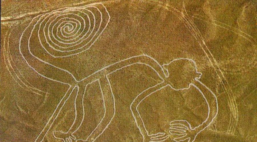
The first incomprehensible lines to Nazca were discovered in 1927 by the Peruvian archaeologist Mejia Xesspe, when he accidentally glanced from a steep mountainside onto a plateau. By 1940, he had discovered several more incredible ancient signs and published the first sensational article. On June 22, 1941 (the day the Great Patriotic War began !!!), the American historian Paul Kosok took a light plane into the air and discovered a giant stylized bird, whose wingspan exceeded 200 meters, and next to it something resembling a landing strip. Then he discovered a giant spider, a monkey with a strangely coiled tail, a whale and finally on a gentle mountain slope a 30-meter figure of a man with a hand raised in greeting. This is how perhaps the most mysterious "picture book in the history of mankind" was discovered.
Over the next sixty years, Nazca has been fairly well studied. The number of discovered drawings has long exceeded several hundred, and the overwhelming majority of them are various geometric shapes. At the same time, some lines reach a length of up to 23 kilometers.
And today, the solution to the mystery has not become closer. What versions and hypotheses were not put forward during this time! They tried to present the drawings as a kind of giant ancient calendar, but no mathematical justification the scientific world was never presented.
One of the hypotheses identified the drawings as some designation of the zones of influence of the Indian clans. But the plateau was never inhabited, and who could deal with these "ger-
bami clans "when they are only visible from a bird's eye view?
There is a version that the images of Nazca are nothing more than an alien airfield. Needless to say, a number of runways are indeed incredibly reminiscent of modern runways and runways, but where is at least some evidence of alien intervention? Others argue that Nazca are signals from an alien mind.
Recently, voices have begun to be heard that Nazca is generally the brainchild of someone's falsification. But then a whole army of counterfeiters had to work in the sweat of their brow over the manufacture of the most gigantic counterfeit i in the history of mankind. How could they, in this case, keep the secret and why did they, in the end, become so disfigured?
The most conservative part of scientists insists that all the variety of drawings and figures was dedicated to a certain god of water: “probably! were a kind of sacrifice to the ancestors or gods of the sky and mountains, who sent people the water that is so necessary for irrigating the fields. " But why was it necessary to turn to the god of water in such a remote place, where permanent residence, no farming, no cultivated fields have never been? The rain poured on Nazca was of no particular benefit to the ancient Peruvians.
It is believed that ancient Indian athletes once ran along the giant ancient lines, that is, some ancient South American Olympiads were held on Nazca. Let's say that athletes could run in straight lines, but how could they run in spirals and in a pattern, for example, monkeys?
There were publications that huge trapezoidal areas were created for the sake of some mass ceremonies, during which sacrifices were made to the gods and mass festivities were carried out. But then why did the archaeologists, who had interrupted all the surroundings, not find a single confirmation of this artifact? In addition, some of the giant trapeziums are located on mountain peaks, which is not so easy for a professional climber to climb.
There is even a completely absurd version that all the gigantic work was done solely for the purpose of a kind of occupational therapy, in order to somehow occupy the idle ancient Peruvians ... They say that all the images of Nazca are nothing more than a giant loom of the ancient Peruvians, who they laid out their threads along the lines, since in the pre-Columbian era, the Americans did not know the wheel and did not have a spinning wheel ... It was even argued that the Nazca drawings were a huge encrypted map of the world. Alas, so far no one has undertaken to decipher it.
The most cautious part of historians defines the drawings and lines of Nazca as some "paths that had a sacred meaning, along which ritual processions were performed." But then again, who could see these paths from the ground?
Until now, scientists have not come to the conclusion how the Nazca drawings were created, because the production of images of such a huge scale presents a huge technical difficulty even today. More or less precisely, only the technology of direct creation of stripes has been established. It was quite simple: the surface layer of stones was removed from the ground, under which the ground had a lighter color. However, the creators of the drawings had to first create sketches of future giant images on a small scale and only then transfer them to the area. How they managed to maintain the accuracy and correctness of all the lines is a mystery! For this, at least, they had to have at hand the entire arsenal of modern geodetic equipment, not to mention the most perfect mathematical knowledge. By the way, today's experimenters were able to repeat only the creation of straight lines, but they were powerless in front of ideal circles and spirals ...
this, the images were created not only on flat areas of the earth. They were applied on very steep slopes and even on almost sheer cliffs! But that's not all! In the Nazca region, there are the Palpa mountains, some of which are cut off like a table, as if a monster had gnawed their top. These gigantic artificial cuts also feature drawings, lines and geometric images.
There is also no unity regarding the construction time. Nowadays, it is customary to divide everything created on the plateau into seven conditional cultures, very spaced in time, from Nazca-1 to Nazca-7. Some archaeologists are inclined to attribute the creation of Nazca drawings to the period from 500 AD. before 1200 AD Others categorically object, since the Inca Indians inhabiting this area of Peru do not have even distant legends regarding Nazca, which gives grounds to attribute the time of the creation of the images to almost 100,000 years BC. They tried to determine the age of the stripes from the remains of fragments of clay shards found nearby. It was believed that ancient builders drank from clay jugs, and then sometimes they were broken. However, on the same strip, shards of all seven cultures were found everywhere and, in the end, this attempt at dating was recognized as unsuccessful.
The scientific study of Nazca today is also hampered by the prohibitions of the authorities. Due to the fact that after the discovery of the drawings, the plateau underwent a real invasion of "wild" tourists who traveled around the plateau in cars and motorcycles, spoiling the drawings, now the appearance directly on the Nazca plateau for anyone is strictly prohibited. Nazca was declared an archaeological park and taken under the protection of the state, and the fine for unauthorized entry into the park is an astronomical amount - 1 million US dollars. All comers, however, can admire the giant ancient images from the board of tourist planes that continuously circle over the mysterious plateau. But for real scientific research, this, you see, is still not enough.
But the secrets of Nazca do not end there. If on the surface of the plateau there are gigantic drawings incomprehensible to human understanding, then in the depths of the caves there are even more incredible pukios - the oldest underground water pipes in granite pipes. There are 29 giant pukios in the Nazca Valley. Today's Indians attribute their creation to the creator god Viracocha, but the channels are the work of human hands. At the same time, one of the canals was laid under the local river Rio de Nazca, so much so that its the purest water in no way mixed with the dirty water of the river! From the description of an eyewitness: “Sometimes stone spirals lead into the depths of the earth, and watercourses have an artificial channel lined with slabs and smoothly hewn boulders. Sometimes the entrance hole is a deep shaft, going into the earth ... Everywhere and everywhere, these underground channels are artificial structures .. ”Pukios is also from the area of eternal mysteries. Who, when and why created these gigantic water structures under a deserted plateau? Who used them?

An ancient clay figurine depicting a dinosaur operation.
In the capital of the Nazca province, the town of Ica, lives the owner of the most incredible collection in the world, professor of medicine, Hanviera Cabrera. He has more than two and a half thousand figurines made of unbaked clay, which the professor gets from the local Indians. The figurines depict the ancient inhabitants of Peru next to ... dinosaurs and pterodactyls. At the same time, the ancient Peruvians perform operations on dinosaurs, fly astride pterodactyls and look into Space through a telescope. The figures are estimated to be between 50,000 and 100,000 years old, or even more. As for the radiocarbon method, it gave very contradictory results. In addition to the figurines, Professor Cabrera's collection contains similar drawings on stones, including those that depict flying vehicles in the starry sky. The collection of Professor Cabrera is no exception. The famous Mexican collection of Acambaro also contains dinosaurs, including flying ones. The same is true in the Ecuadorian collection of Pater Crécy. In addition, there is a collection of Russell Burrows, who found statues in the caves of Illinois with strikingly similar themes. The same thing was found not so long ago in Japan. Falsification in this case is impossible even theoretically! Well, and, finally, the most scandalous find on the Paluxy River in the American state of Texas, where archaeologists discovered dinosaur bones and fossilized human footprints in the same rock! So people lived already in the era of dinosaurs, or, conversely, dinosaurs lived in the era of people! But both completely change our ideas about the beginning of the human era, and therefore one can imagine how much irritation, misunderstanding and just outright opposition these findings cause among the elite of the scientific world, who have made a name for themselves on those hypotheses that are now completely crossed out by the findings of recent years!
And how not to recall here the seemingly absurd assumptions of the Crimean Academician A.V. Gokh, who says that it is necessary to create huge amount repeaters of the Crimean pyramids squirrels, was obtained from huge dinosaur eggs. It should be admitted that the statements of the Crimean academician now do not look so groundless.
Now, I think, the time has come to present to the readers the hypothesis of the Emil Bagirov Institute regarding the giant geoglyphs in the Nazca desert. However, to begin with, there are two more facts.
First. Quite recently, by the works of the German researcher Erich von Daniken (known to us from the sensational publicistic film "Recollection of the Future"), a giant ... classic MANDALA was discovered in Nazca! Yes Yes! The same sacred man-dapa, with the help of which today's Tibetans and Hindus designate the pictures they contemplate during meditation! The same mandala, which was once a sacred sign of the Aryans and one of the main Vedic symbols. Is it a coincidence? No way!
Second. Ancient texts of the Old World are ubiquitous about some aircraft, moreover, devices of completely terrestrial origin.
For example, in the "Book of the Greatness of Kings" the flights of King Solomon are fully described: in one day they covered a three-month journey ... He (Solomon) gave her all sorts of wonders and treasures that one could wish for and a chariot that moves through the air and which he created according to the wisdom given to him by God ...
And the inhabitants of the land of Egypt told them: in ancient times the Ethiopians visited here; they moved in a chariot like an angel, and at the same time they flew faster than an eagle in the sky. " Quotations from the famous Mahatbharata are no less indicative: “l / i then the king (Rumanvat) with his servants and harem, with his wives and nobles entered the heavenly chariot. They flew around the entire width of the sky, following the direction of the wind. The celestial chariot flew over the whole earth, (flying) over the oceans, and headed towards the city of Avantis, where the holiday was taking place. After a short stop, the king again took to the air in front of countless onlookers, who were amazed at the sight of the heavenly chariot. "
Or here's another: “Arjuna, the terror of the enemies, wanted Indra to send his celestial chariot for him. And then, in the radiance of light, a chariot suddenly appeared, illuminating the airy twilight and illuminating the clouds around and all the surroundings were filled with a roar, similar to the rolling of thunder ... "
So all Indian sources claim that the ancient Aryan civilization had air ships - vimans. We find echoes of these unusual means of transportation in the legends of the peoples of the Aryan area, for example, the famous Russian fairy tales about a flying ship and so on. But for takeoff and landing, the vimans needed runways and runways. Are there traces of them in the Old World? As it turns out there is! At the present time, at least three are already known: one in England, the second on the Ustyurt plateau near the Aral Sea and the third in Saudi Arabia... At the same time, similar giant geoglyphs were found everywhere, as in Nazca, although in smaller numbers. And this despite the fact that no targeted searches for airports of antiquity have never been carried out anywhere.
So what can you suggest? After the destruction of the Tower of Babel, that is, after the collapse of the single ancient Vedic faith into several concessions, a vigorous migration of the Aryan tribes began, and with it the export of Vedic religion and knowledge. Of course, the main settlement of the Aryans was by land. It spread throughout Eurasia, where Vedic influence is felt everywhere to this day. However, most likely, some of the Aryans also used the mysterious Vimanas, which, as we already know, had a long flight range and could fly over the oceans. It was then, most likely, that followed the heroic rush across Africa and the Atlantic to South America. But why was the landing made specifically on Nazca? It can be assumed that for some time this region attracted the Aryans because the Nazca region is rich in deposits of iron and copper ore, gold and silver. Let us also pay attention to the fact that very ancient abandoned mines for the extraction of all these metals were discovered in the Nazca region.
Apparently, for some time the Aryans from the arrived Vimans lived in these places. They brought local residents into obedience, organized the extraction of metals, introduced and spread among the ancient Peruvians the cult of the Great Goddess-First Mother, the Holy-Logo-Horse, the immortality of the soul and rebirth. It was then that the runways and geometric signs were built, allowing the vimanas to correctly aim at them, underground water conduits, which facilitate the provision of water. It seems that the Vimans actively carried out the export of mined metals to Egypt or some other countries that were in the area of the then Aryan influence. It is possible that the Aryans also used tamed local pterodactyls for short-range flights, which was captured in the ancient clay figurines of Peru. Apparently, there was such an experience. Suffice it to recall the same "Avesta" and "Rigveda", numerous European-Aryan mythology, where heroes very often use flying lizards as a quite suitable means of transportation. The same Russian heroes, for example, on occasion willingly used the legendary Serpent Gorynych for this purpose ...
However, the time has come and the Aryans who settled on Nazca, having fulfilled their mission, left forever a place that was not very suitable for permanent residence, leaving the Vedic cults, knowledge of crafts and the firm belief that the people-gods who had flown away would definitely return someday. It was then, apparently, that the intensive creation of many drawings began, so that the gods flying in the sky past Nazca saw that they were still awaited here, as, incidentally, in other places in America, where similar geoglyphs are now found. At the same time, they drew what, in the opinion of the Indians, those who flew away liked most of all, what once surprised and amused them: unusual monkeys, hummingbirds, whales, iguanas.
Fortunately, the Aryans left the secrets of the technology for creating grandiose images to the local residents. That is why, among other drawings, the Indians placed a grandiose mandala - the sacred Vedic sign of the Aryans, quite logically assuming that seeing it, the people-gods will definitely return to this land, where they are so loved and so devotedly awaited. But, alas, none of the gods ever returned.
Centuries passed, millennia. The foundations of the Vedic faith, once laid here by the Aryan priests, over time, intricately intertwined with local cults. However, the pyramids, the cult of the Sun, and many priestly rituals still strikingly resemble their Vedic foundations. All this time, the Indians patiently waited for the fair-haired bearded people-gods carrying great faith and great knowledge. The time has come and bearded men, chained in iron, came from the west, but instead of the long-awaited blessings, they brought destruction and death. However, this is a completely different story ...
The Nazca Desert is located in the south of Peru, 450 kilometers from Lima. This is the region inhabited by the Preink civilization of Nazca (I-VI centuries AD).
The Nazca people waged wars and were engaged in trade, but the main activity for them was fishing and agriculture. In addition, the Nazca were excellent artists and architects - we can judge this by the found ceramics of this culture and the ruins of ancient cities. Many evidences of the high level of development of this civilization have survived, the main of which are undoubtedly the Nazca Lines - huge geoglyphs in the desert, visible only from a bird's eye view.
What to see
Nazca Lines
Giant drawings in the desert depicting animals and various objects - the Nazca Lines - were discovered in 1926. Researchers suggest that geoglyphs were created in the years 300-800 by the Nazca civilization. They were called “the largest calendar in the world”, “the most gigantic book about astronomy” - their exact purpose remains unknown.
The area of the territory on which the Nazca Lines are located occupies 500 km2 and is located in the desert, where it rains for only half an hour a year. It is this fact that allowed the geoglyphs to survive to this day.
These drawings were first described in 1548, but for many years no one paid serious attention to them. Perhaps this was due to the fact that they can be properly examined only from a height, and they began to fly in airplanes over the desert much later. In the early 1940s, during the construction of the Pan American Highway, an American professor invited to study coastal hydrology regularly flew over valleys in small planes. It was he who drew attention to the strange lines forming huge drawings. The sight that opened up shocked and amazed him. Professor Kosok and other scientists have devoted many years to the study of these lines. They managed to find the connection of the location of the lines with the sun on the days of the summer and winter solstices, as well as indications of the moon, planets and bright constellations. It seemed that the Nazca civilization set up a gigantic observatory here.
The technique of creating geoglyphs was very simple: the upper darkened layer was cut off from the soil and folded here, along the formed light strip, creating a roller of a darker color framing the line. Over time, the color of the lines darkened and became less contrasting, but we can still see the drawings left by the Nazca civilization.

How to view
There are several companies in Nazca that make excursion flights in small planes over the desert. Such, since due to the number of people who want to inspect the Lines of places on the desired date in last moment may not be.
An alternative way to see the lines is to go up to the observation deck on the Panamerican Highway (El Mirador). The cost of lifting is 2 salt (20 rubles), but you can only see 2 drawings.
Palpa Lines
Unlike the Nazca drawings, the Palpa Lines consist more of images of a person and geometric patterns... According to archaeological research, the Palpa Lines are more than early period than the Nazca Lines. Flying over the Palpa Lines, you can see the image of the Pelican, the image of a woman, a man and a boy, whom archaeologists call "The Family". One of the Palpa Lines is an image of the Hummingbird - similar to one of the geoglyphs of the Nazca Lines. Another Line is read by archaeologists as an image of the Dog near the Square. Near the town of Palpa you can see famous image Sundial and Tumi - a ritual knife.


Ruins of Cahuachi
The most important and powerful city of the Nazca civilization was Cahuachi - a city in the Nazca Valley, 24 km from the modern city of Nazca. Excavations are still underway here. Today, the following remains of the city:
- The Central Pyramid is 28 meters high and 100 meters wide, consisting of 7 steps. Religious ceremonies were held here.
- Stepped Temple 5 meters high and 25 meters wide
- 40 buildings from adoba (adobe brick)
There was a necropolis near the city, in which scientists found intact burials with various objects that were customarily placed in graves (dishes, fabrics, jewelry, etc.). All finds can be seen in the Antonini Archaeological Museum (Museo Arqueológico Antonini) in Nazca.

Necropolis of Chauchilla (El cementerio de Chauchilla)
The Chauchilla necropolis is located 30 km from the city of Nazca. This is the only place in Peru where you can see the mummies of the ancient civilization directly in the graves where they were found. This cemetery was used from the 3rd to the 9th centuries AD, but the main burials date back to 600-700 years. The mummies are well preserved thanks to the arid desert climate, as well as the embalming technology used by Nazca: the bodies of the dead were wrapped in cotton cloth, painted with paints and impregnated with resins. It was the resins that helped to avoid the decomposing action of bacteria.
The necropolis was discovered in 1920, but officially recognized as an archaeological monument and taken under protection only in 1997. Prior to that, he suffered for many years from marauders who stole a significant part of the Nazca treasures.
2-hour guided tour - 30 Soleil
Entrance ticket to the Necropolis - 5 Soleil

San Fernando Nature Reserve (Bahía de San Fernando)
About 80 km from Nazca there is a nature reserve very similar to Paracas. Here you can also see penguins, sea lions, dolphins, and various birds. In addition, the Andean fox, guanacos and condors are found in San Fernando.
It is difficult to get here and there are almost no tourists here.In San Fernando, you can spend time alone with nature and the Pacific Ocean!

Cantayoc aqueducts
The Nazca were a very advanced civilization. In a desert environment, where the river is filled with water for only 40 days a year, the farmers of Nazca needed a system that allows them to have water throughout the year. They solved this problem by creating a magnificent aqueduct system. One of them - the Cantayoc Aqueducts are located less than 5 km from the city of Nazca and are a chain of spiral wells.
When to go
Nazca is located in the desert, where it is almost always dry and sunny. From December to March, the hottest time in this region is, the average daily temperature is around 27C. June to September are the coldest months of the year when the daytime temperature is only 18C.
How to get to Nazca
Nazca is located 450 kilometers south of Lima. You can get here on your own by car along the Panamericana highway, or by one of the many buses that go in this direction. The bus trip will take 7 hours.
The Nazca Lines still cause a lot of controversy as to who created them and when they appeared. Strange outlines, clearly visible from a bird's eye view, resemble geometric shapes, even stripes, and even representatives of the fauna. The dimensions of the geoglyphs are so large that it is not possible to understand how these images were drawn.
Nazca Lines: Discovery History
Strange geoglyphs - traces on the surface of the earth, were first discovered in 1939 on the Nazca plateau in Peru. American Paul Kosok, flying over the plateau, noticed strange drawings, reminiscent of birds and animals of enormous size. The images intersected with lines and geometric shapes, but stood out so clearly that it was impossible to doubt what they saw. 
Later in 1941, Maria Reiche began researching strange shapes on a sandy surface. However, it was possible to take a photo of an unusual place only in 1947. For more than half a century, Maria Reiche devoted herself to deciphering strange symbols, but a final conclusion was never provided. 
Today, the desert is considered a conservation area, and the right to explore it has been transferred to the Peruvian Institute of Culture. Due to the fact that the study of such a vast location requires huge investments, further scientific work on deciphering the Nazca lines has so far been suspended.
Description of Nazca drawings
If you look from the air, the lines on the plain are clearly visible, but walking in the desert, it is unlikely that you will be able to understand that something is depicted on the ground. For this reason, they were not discovered until aviation became more developed. Small hills on the plateau distort the pictures, which are drawn by means of trenches dug across the entire surface. The width of the furrows reaches 135 cm, and their depth is from 40 to 50 cm, while the soil is identical everywhere. It is due to the impressive size of the lines that they are visible from a height, although they are hardly noticeable in the process of walking. 
Among the illustrations are clearly visible:
- birds and animals;
- geometric figures;
- chaotic lines.

The dimensions of the printed images are quite large. So, the condor stretches for a distance of almost 120 m, and the lizard reaches 188 m in length.There is even a drawing that resembles an astronaut, whose height is 30 m. the trench seems impossible.
Hypotheses of the nature of the appearance of lines
Scientists from different countries have tried to figure out where the lines point and by whom they were laid. There was a theory that such images were made by the Incas, but research has proven that they were created much earlier than the existence of the nationality. The approximate period, which dates the appearance of the Nazca lines, is considered to be the 2nd century BC. NS. It was at this time that the Nazca tribe lived on the territory of the plateau. In a village belonging to the people, sketches were found that resemble drawings in the desert, which once again confirms the guesses of scientists.
Maria Reiche deciphered some symbols, which allowed her to put forward a hypothesis that the drawings reflect a map of the starry sky, and therefore were used for astronomical or astrological purposes. True, this theory was later refuted, since only a quarter of the images fit the known astronomical bodies, which seems insufficient for an accurate conclusion. 
V currently it is still not known why the Nazca lines were drawn and how the people who did not possess the skills of writing managed to reproduce such traces on an area of 350 square meters. km.
The Nazca Plateau today is a lifeless desert, covered with stones darkened by the heat and sun and cut by the beds of long-dried water streams; one of the driest places on earth. Located 450 km south of Lima, the capital of Peru, 40 km from the coast The Pacific, at an altitude of about 450 m. It rains here on average once every two years and lasts no more than half an hour.

In the twenties, with the beginning of flights from Lima to Arequipa, strange lines began to be noticed on the plateau. Lots of lines. Straight as an arrow, sometimes stretching to the very horizon, wide and narrow, intersecting and overlapping, combining into unthinkable schemes and scattering from the centers, the lines made the desert look like a giant drawing board:

Since the middle of the last century, a serious study of the lines and cultures that inhabited this region began, but the geoglyphs still kept their secrets; versions began to appear explaining the phenomenon outside the mainstream of academic science, the topic took its rightful place among the unsolved mysteries of ancient civilizations, and now almost everyone knows about the Nazca geoglyphs.
Representatives of official science have repeatedly stated that everything has been solved and deciphered, that it is nothing more than traces of religious ceremonies, well, or, in extreme cases, traces of searches for water sources or the remains of astronomical indicators. But it is enough to look at the pictures from an airplane, or better from space, as there are fair doubts and questions - what are these rituals that forced two thousand years ago the Indians, whose society was in the earliest stages of development, who did not have a written language, who lived in small villages and farms, forced to constantly struggle for survival, outline hundreds of square kilometers of desert with geometric shapes, many kilometers of straight lines and giant design images that can only be seen from a great height?
Maria Reiche, who has devoted more than 50 years to the study of geoglyphs, notes in her book that, given the enormous amount of work carried out, the creation of lines should have been the central task of the society that inhabited this area at that time ...
Although it is worth noting that in more specialized works, archaeologists do not adhere to such categorical conclusions about the complete solution of the lines, mentioning religious ceremonies only as the most likely version requiring further research.
And I propose to touch again this amazing riddle, but only maybe a little more closely, as if from another dimension; to do similar to what P. Kosok did in 1939, when he first specially hired a plane to fly over the desert.
So, here's a little information you need to know.
1927 Official discovery of the lines by the Peruvian archaeologist Toribio Meia Xespe.
1939 Geoglyph research begins by historian Paul Kosok of Long Island University in New York.
1946 - 1998 Study of geoglyphs by the German mathematician and archaeologist Maria Reiche. Arriving for the first time with Paul Kosok as a translator, Maria Reiche continued her research on the lines that became the main work of her life. Largely thanks to this courageous woman, the lines continue to exist and are available for research.
1960 The beginning of an intensive study of geoglyphs by various expeditions and researchers.
1968 Release of the book by Erich von Denikin "Chariots of the Gods", which expresses the version of traces of extraterrestrial civilizations. The beginning of the widespread popularity of the Nazca geoglyphs and the tourist boom on the plateau.
1973 Expedition of the English astronomer Gerald Hawkins (author of a monograph about Stonehenge), the results of which showed the inconsistency of the astronomical version proposed by P. Kosak and M. Reiche.
1994 Thanks to the efforts of Maria Reiche, the Nazca geoglyphs are included in the UNESCO World Heritage List.
Since 1997, the Nazca-Palpa project, led by the Peruvian archaeologist Joni Isla and prof. Markus Reindel from the German Archaeological Institute with the support of the Swiss-Liechtenstein Foundation for Foreign Archaeological Research. The main version based on the results of work since 1997 is the already mentioned ritual actions associated with the cult of water and fertility.
Currently, a GIS is being created - a geoinformation system (digital 3-dimensional display of geoglyphs combined with archaeological and geological information) with the participation of the Zurich Institute of Geodesy and Photogrammetry.
A little about the versions. The two most popular ones have already been mentioned (Indian rituals and traces of extraterrestrial civilizations):

To begin with, let's clarify a little the meaning of the term "geoglyphs" itself. According to wikipedia, "a geoglyph is a geometric or figured pattern applied to the ground, usually over 4 meters long. There are two ways to create geoglyphs - by removing the top layer of soil around the perimeter of the pattern, or, conversely, pouring rubble where the pattern line should pass. Many geoglyphs are so large that they can only be viewed from the air. " It should be added that, in its overwhelming majority, geoglyphs are quite unambiguously interpreted drawings or signs, and from ancient times to the present day people have applied and are applying geoglyphs for specific purposes - religious, ideological, technical, entertainment, advertising. Nowadays, thanks to technological progress, application methods have significantly improved, and, ultimately, both the illuminated runway and artificial islands in the United Arab Emirates can be considered modern geoglyphs:

According to the above, the Nazca lines (the number of giant drawings is only a fraction of a percent of the number of lines and geometric shapes) to consider as geoglyphs is not entirely correct, due to the unknown purpose with which they were applied. After all, it never occurs to anyone to consider as geoglyphs, say, agricultural activities or the transport system, which from a great height also look like geometric patterns. But it so happened that in official archeology, and in popular literature, Nazca lines and drawings are called geoglyphs. We will not break traditions either.
1. LINES
Geoglyphs are found almost all along the west coast South America... In this chapter, we will take a closer look at the geoglyphs in the Nazca region, and information about other regions can be found in the appendix.
On the next map, areas are marked in blue where the lines are clearly visible in Google earth and have a similar structure; red rectangle - "tourist place", where the density of lines is maximum and most of the drawings are concentrated; the purple area is the area of distribution of lines, considered in most studies, when they say "Nazca-Palpa geoglyphs" they mean this area. The purple icon in the upper left corner is the famous "Paracas Candelabrum" geoglyph:

Red rectangle area:

Purple area:

The geoglyphs themselves are a fairly simple thing - the stones covered with a dark desert tan (manganese and iron oxides) were removed to the side, thereby exposing the light layer of the subsoil, consisting of a mixture of sand, clay and gypsum:

But often geoglyphs have a more complex structure - deepening, an orderly border, stone structures, or simply heaps of stones at the ends of the lines, which is why in some works they are called earth structures.
Where the geoglyphs go to the mountains, a lighter layer of rubble was exposed:

In this chapter, we will mainly focus on the majority of geoglyphs, which includes lines and geometric shapes.
According to their form, they are usually divided as follows:
Lines and stripes with a width of 15 cm to 10 or more meters, which can stretch for many kilometers (1-3 km are quite common, some sources mention 18 or more km). Most of the drawings are drawn with thin lines. The stripes sometimes smoothly widen along their entire length:

Truncated and elongated triangles (the most common form of geometric shapes on a plateau after lines) of various sizes (from 3 m to more than 1 km) - they are usually called trapezoids:

Large areas of rectangular and irregular shape:

Often, the lines and platforms are deepened, according to M. Reiche, up to 30 cm or more, the depressions at the lines often have an arched profile:

This is clearly seen on almost covered trapezoids:

Or in a photo taken by a member of the LAI expedition:

The shoot place:

Lines almost always have well-defined boundaries - basically it is something like a border, very precisely maintained along the entire length of the line. But also the boundaries can be heaps of stones (for large trapezoids and rectangles, as in Fig. 15) or heaps of stones with varying degrees of ordering:

Let us note the feature due to which the Nazca geoglyphs gained wide popularity - straightforwardness. In 1973 J. Hawkins wrote that several kilometers of straight lines were made at the limit of photogrammetric capabilities. I don’t know how things are now, but you must admit that it’s not bad at all for the Indians. It should be added that often the lines follow the relief, as if not noticing it.

Examples that have become classic:


Airplane view:

The centers are easy to read on map 6. Map of the centers by Maria Reiche (small dots):

American researcher Anthony Aveni in his book "Between lines" mentions 62 centers in the Nazca-Palpa region.
Often the lines are connected to each other and combined in various combinations. It is also noticeable that the work went in several stages, often lines and figures cover each other:

It is worth noting the location of the trapezoids. The bases usually face river valleys, the narrowest part is almost always higher than the base. Although where the elevation difference is small (on flat hilltops or in the desert) this does not work:

A few words must be said about the age and number of lines. Official science is considered to be that the lines were created in the period between 400 BC. NS. and 600 AD The reason for this is the fragments of pottery from different phases of the Nazca culture, which are found in dumps and heaps of stones on the lines, as well as radiocarbon analysis of the remains of wooden posts, considered marking. Thermoluminescent dating is also used and shows similar results. We will touch on this topic below.
As for the number of lines - Maria Reiche registered about 9,000 of them, at present, the figure from 13,000 to 30,000 is mentioned (and this is only on the purple part of map 5; no one counted similar lines in Ica and Pisco, although there they are obviously far less). But it must be borne in mind that we see only what left us with the time and cares of Maria Reiche (now the Nazca plateau is a reserve), who mentioned in her book that before her eyes, areas with interesting lines and spirals are being set up for cotton crops. Obviously, most of them were buried by erosion, sands and human activity, and the lines themselves sometimes cover each other in several layers, and their true number may differ by at least an order of magnitude. It makes sense to talk not about the number, but about the density of the lines. And here it is worth noting the following.
Given that the climate, as archaeologists point out, during this period was more humid (and Google Earth shows that the ruins and remnants of irrigation structures go deep into the desert), the maximum density of geoglyphs is observed near river valleys and settlements (Map 7). But you can find separate lines both in the mountains and far in the desert:

At an altitude of 2000 m, 50 km west of Nazca:

A trapezoid from a group of lines in the desert 25 km from Ica:

And further. When compiling GIS for some areas of Palpa and Nazca, it was concluded that, in general, all the lines were built in places accessible to humans and what happens on the lines (but not the lines themselves) can be seen from distant observation points. I don’t know about the second, but the first seems to be true for the overwhelming majority of the lines (there are inconvenient places, but I haven’t met any impassable ones), especially since Google Earth allows you to rotate the image this way and that (purple area on map 5):


The list of obvious features could be continued, but perhaps it's time to move on to the details.
The first thing I would like to start with is a significant amount of work done, to put it mildly, not very high-quality:

Most of the images were taken within the purple area on Map 5, which was the most affected by tourists and various kinds of experimenters; according to Reiche, there were even military exercises here. I tried as much as possible to avoid clearly modern traces, especially since it is not difficult - they are lighter, go over ancient lines and do not have traces of erosion.
A few more illustrative examples:


The ancients had strange rituals - would it be worthwhile to engage in such a volume of work on marking and clearing that then halfway or even at the final part of it would be abandoned? It is interesting that sometimes on completely finished trapezoids there are often heaps of stones, as it were, abandoned or forgotten by the builders:

According to archaeologists, work on the construction and reconstruction of the lines was carried out constantly. I will add that this is more likely to concern only some of the line groups located near Palpa and in the Ingenio river valley. There, all kinds of activity did not stop, possibly during the time of the Incas, judging by the numerous stone structures around the bases of the trapezoids:

Some of these places are sometimes, as it were, marked by anthropomorphic and rather primitive images-geoglyphs, reminiscent of the usual cave drawings(historians attribute them to the style of the Paracas culture, 400-100 BC, the predecessor of the Nazca culture). It is clearly seen that there are a lot of tramples (including modern tourists):


I must say that such places are mainly preferred by archaeologists to study.
Here we come to one extremely interesting detail.
You have noticed that I constantly mention heaps and structures of stone - they made borders from them, arbitrarily left them on the lines. But there is another type of similar elements, as if included in the design of a significant number of trapezoids. Notice two elements at the narrow end and one at the wide:

The detail is important, so more examples:

In this Google image, several trapezoids have similar elements:

These elements are not the latest additions - they are present on some unfinished trapezoids, they are also found in all 5 regions indicated on the map. Here are examples from opposite ends - the first from the Pisco area, and two from the mountainous section east of Nazca. Interestingly, on the latter, these elements are also present inside the trapezoid:

Archaeologists have recently become interested in these elements, and here are descriptions of these structures on one of the trapezoids in the Palpa region (1):
Stone platforms with walls of stones, fastened with mud, sometimes double (the outer wall was made of flat sides of the stone, giving a splendor), filled with rocks, among which there are fragments of ceramics and remnants of food products; there was a raised floor made of compacted clay and stone inserts. It is assumed that wooden beams were placed on top of these structures and used as platforms.

The diagram shows the pits between the platforms, where the remains of wooden (willow) pillars, presumably massive, were found. Radiocarbon analysis of one of the pillars showed an age of 340-425 A.D., a piece of a stick from a stone platform (another trapezoid) - 420-540 A.D. NS. Pits with the remains of pillars were also found on the borders of the trapezoids.
Here is a description of the circular structure found near the trapezoid and, according to archaeologists, similar to those found at the base of the trapezoid:
In terms of the construction method, it is similar to the platforms described above, with the difference that the inner part of the wall was also given a splendor. It had the shape of the letter D, with a gap made on the flat side. A flat stone is visible, erected after reconstruction, but it is noted that there was a second, and both were used as props for the stairs to the platform.

In most cases, these elements did not have such a complex structure and were simply heaps or ring structures of stones, and a single element at the base of the trapezoid could not be read at all.

And more examples:


We dwelled on this point in more detail, because it is quite obvious that the platforms were built together with trapezoids. They can be seen very often in Google Earth, and ring structures are very well distinguishable. And it is unlikely that the Indians were specifically looking for trapezoids to build platforms on them. Sometimes even the trapezoid is barely guessed, but these elements are clearly visible (for example, in
desert 20 km from Ica):

Large rectangular areas have a slightly different set of elements - two large piles of stones, one at each edge. Perhaps one of them is featured in the National Geographic documentary "Nazca Lines. Transcribed":

Well, a sure point in favor of rituals.
Based on our orthodox version, it is logical to assume that some kind of markup must exist. Something similar really exists and is very often used - a thin central line running along the center of the trapezoid and sometimes going far beyond. In some works of archaeologists, it is sometimes called the centerline of the trapezoid. It is usually tied to the platforms described above.
(starts or passes side by side through the platform at the base, and always exactly exits in the middle between the platforms at the narrow end), the trapezoid may not be symmetrical about it (and the platforms, respectively):

This is true for all selected areas of map 5. The trapezoid from Iki is indicative in this respect. 28, the centerline of which seems to shoot a line from heaps of stones.
Examples of different types of markings for trapezoids and stripes, as well as various types of work on them in the purple area (we called them mattresses and punched tapes):


The markup in some of the examples shown is no longer a simple delineation of the main axes and contours. There are elements of a kind of scanning of the entire area of the future geoglyph.
This is especially noticeable in the markings for large rectangular areas from the "tourist spot" by the Ingenio River:
Under the platform:

And here, next to the existing site, another one was marked out:

A similar markup for future sites on the layout of M. Reiche is well read:

Let's take a note of the "scanning markup" and move on.
Interestingly, the sweepers and those who did the clearing work did not seem to be able to coordinate sufficiently at times:


And an example of two large trapezoids. Interestingly, it was so conceived, or someone confused something:
Considering all of the above, it was difficult not to try to get a closer look at the actions of the markers.
And here we have a few more extremely entertaining details.
To begin with, I will say that it is very revealing to compare the behavior of modern transport and ancient markers using a thin line. Tracks of cars and motorcycles walk unevenly along one direction, and it is difficult to find straight sections of more than a couple of hundred meters. At the same time, the ancient line is always almost straight, often inexorably moving for many kilometers (checked in Google with a ruler), at times disappearing, as if taking off from the ground, and reappearing in the same direction; occasionally it can make a slight bend, change direction abruptly or not very much; and in the end either rests against the center of intersections, or smoothly disappears, dissolving in a trapezoid, crossing a line or with a change in relief.
Often, markers seem to lean on heaps of stones located next to the lines, and less often on the lines themselves:

Or an example like this:

I have already spoken about straightforwardness, but I will note the following.
Some lines and trapezoids, even distorted by the relief, become straight from a certain point of view from the air, which has already been noted in some studies. For example. A slightly walking line in the satellite image looks almost straight from the point of view, which is slightly off to the side (frame from the documentary "Nazca Lines. Deciphered"):

I am not an expert in the field of geodesy, but, in my opinion, to draw a line on rough terrain along which an inclined plane crosses the relief is a rather difficult task.
Another similar example. On the left is a picture from an airplane, on the right from a satellite. In the center is a fragment of an old photograph by Paul Kosok (taken from the lower right corner of the original photograph from M. Reiche's book). We see that the whole combination of lines and trapezoids is drawn from a point close to the point from which the central image was taken.

And the next photo is better viewed in good resolution (here - Fig. 63).

First, let's pay attention to the undeveloped area in the center. Methods of manual work are very clearly presented - there are both large heaps and small ones, a dump of gravel at the borders, an irregular border, not very organized work - they collected it here and there and left. In short, everything that we saw in the section on manual work.
Now let's look at the line crossing the left side of the photo from top to bottom. A radically different style of work. The ancient aces-builders seem to have decided to imitate the work of a chisel fixed at a certain height. With a jump across the stream. Straight and regular borders, leveled bottom; did not even forget to reproduce the subtleties of cutting off the trace of the upper part of the line. There is a chance that this
water or wind erosion. But examples of all kinds of impact the environment there is enough in the photographs - not like either one or the other. Yes, and on the surrounding lines it would be noticeable. Here, however, it is rather an intentional interruption of the line by about 25 meters. If we add a concave line profile, as in old photographs or from a photo in the Palpa area, and a ton of rock that needs to be shoveled (the line width is about 4 m), then the picture will be complete. Also indicative are the four perpendicular thin parallel lines clearly drawn on top. If you look closely, you can see that the depth of the lines also changes on the unevenness of the relief; looks like a trace drawn along a ruler with a metal fork over a piece of plasticine.
For myself, I dubbed such lines t-lines (lines made using technology, i.e. taking into account the use of special methods of marking, performance and control of work). Similar features have already been noted by some researchers. There is a photo of similar lines on the website (24) and the similar behavior of some lines (line interruption and interaction with the relief) is noted in the article (1).
A similar example, where you can also compare the level of work (two "rough" lines are marked with arrows):

Which is remarkable. The unfinished rough line (the one in the center) has a thin marking line. But markings for t-lines have never been encountered. As well as unfinished t-lines.
Here are some more examples:


According to the "ritual" version, they had to walk along the lines. In one documentary, Discovery showed the internal dense structure of the lines, presumably arising from intensive walking along them (the magnetic anomalies recorded on the lines are explained by the compaction of the rock):

And in order to trample on, they had to walk a lot. Not just a lot, but a lot. It is only interesting how the ancients defined the routes in Fig. 67 to trample lines approximately evenly? And how did you jump 25 meters?
It is a pity that photos with sufficient resolution only cover the "tourist" part of our map. So from other areas we will be content with maps from Google Earth.
Rough work at the bottom of the image and t-lines at the top:

And these t-lines in a similar way stretch for about 4 km:

T-lines were able to make turns:

And such a detail. If we return to the t-line, which we discussed the very first, and look at its beginning, we will see a small extension, reminiscent of a trapezoid, which further develops into a t-line and, very smoothly changing its width and sharply changing direction four times, crosses itself , and dissolves into a large rectangle (an unfinished site, obviously of a later origin):


Sometimes there was some kind of malfunction in the work of the markers (curves with stones at the end of the stripes):

There are also large trapezoids, similar to the work of markers. For example. A well-made trapezoid with border-borders, as it were, grows by pushing the borders out of the mark's dent line:

Another interesting example. A fairly large trapezoid (about two thirds of the entire length in the picture), made as if by pushing the cutting edges of the "cutter" apart, and in the narrow part one of the edges stops touching the surface:
Such oddities are enough. Most of the discussed area of our map seems to be the work of those same markers, well mixed with rough, unskilled work. Archaeologist Heilen Silverman once compared the plateau with a striated chalkboard at the end of a busy school day. Very well noticed. But I would add something about the joint classes of the preschool group and graduate students.
There are attempts to make lines by hand in our time available to the ancient Nazcans by means:

The ancients did something similar, and, perhaps, in exactly these ways:

But in my opinion, the t-lines resemble something else. They rather look like a spatula mark, with which they imitated Nazca drawings in one of the documentaries:

And here is a comparison of the t-lines and the trace of the stack on plasticine:

Something like this. Only a spatula or a stack they had a little more ...
And the last thing. A note about markers. There is such a recently opened religious center of the ancient Nazcans - Cahuachi. It is believed to be directly related to the construction of the lines. And if we compare, at the same scale, this same Cahuachi with a section of the desert lined a kilometer from it, the question arises - if the Nazcan surveyors themselves painted the desert, then they invited Cahuachi to mark
migrant workers from the backward mountain tribes?

Draw a clear line between unskilled work and t-lines and draw any conclusions, using only photographs of the "tourist" area and Google maps earth is impossible. It is necessary to look and study on the spot. And since the chapter is devoted to material that claims to be factual, I will refrain from commenting on such sophisticated rituals; and therefore we finish the discussion of t-lines and move on to the concluding part of the chapter.
Combinations of lines
The fact that the lines form certain groups and combinations has been noted by many researchers. For example, prof. M. Reindel called them functional units. A bit of clarification. Combinations do not mean a simple superimposition of lines on top of each other, but a kind of unification into one whole through common boundaries or obvious interaction with each other. And in order to try to understand the logic of creating combinations, I propose to begin with systematizing the set of elements that the builders used. And, as we can see, great variety there is no:

There are four elements in total. Trapezoids, rectangles, lines and spirals. There are also drawings, but a whole chapter is devoted to them; here we will consider them a kind of spirals.
Let's start at the end.
Spirals. This is a fairly common element, there are about a hundred of them and they are almost always included in line combinations. There are very different ones - perfect and not quite, square and intricate, but always double:

The next element is lines. These are mainly our familiar t-lines.
Rectangles - they were also mentioned. There are only two things to note. First. There are relatively few of them and they always try to be oriented perpendicularly to the trapezoids and gravitate towards their narrow part, sometimes, as it were, crossing them out (Map 6). Second. In the valley of the Nazca River, there are a significant number of large broken rectangles, as if superimposed on the beds of dried up rivers. In the sketches, they are indicated mainly in yellow:
The border of such a site is clearly visible in Fig. 69 (bottom).
And the last element is a trapezoid. Along with lines, the most common element on the plateau. A few details:

1 - Location in relation to stone structures and types of boundaries. As already noted, very often stone structures are poorly readable, or they are absent at all. Some functionality of trapezoids is also observed. I would not like to militarize the description, but an analogy with small arms comes to mind. The trapezoid, as it were, has a muzzle (narrow) and a breech, each of which interacts with other lines in a fairly standard way.
For myself, I divided all combinations of lines into two types - collapsed and expanded. The trapezoid is the main element in all combinations. Collapsed (group 2 in the diagram) is when the line exits the narrow end of the trapezoid at an angle of about 90 degrees (or less). This combination is usually compact, with a thin line often returning to the base of the trapezoid, sometimes with a spiral or pattern.
Flattened (group 3) - the outgoing line hardly changes direction. The simplest unfolded is a trapezoid with a thin line, as if shooting from a narrow part and stretching for a considerable distance.
A couple more important details before moving on to the examples. In the folded combinations, there are no stone structures on the trapezoid, and the base (wide part) sometimes has a number of lines:

It can be seen that the last row in the last example was laid out by caring restorers. Snapshot of the last example from the ground:

In those deployed on the contrary, stone structures are very often present, and the base has an additional trapezoid or trapezoids of a much smaller size, joining (in series or parallel) to the place of a single platform (possibly taking it outside the main one):


For the first time, Maria Reiche described the folded combination of lines. She called it a "whip":

From the narrow end of the trapezoid at an acute angle in the direction of the base there is a line, which, as if scanning the surrounding space in a zigzag (in this case, relief features), coils into a spiral in the immediate vicinity of the base. Here's the collapsed combination. We substitute different variations of these elements and we get a very common combination in the Nazca-Palpa area.
An example with another version of the zigzag:
More examples:

Examples of larger and more complex folded combinations in typical interaction with a rectangular pad:

On the map, multi-colored asterisks show well-read folded combinations in the Palpa-Nazca region:

A very interesting example of a group of folded combinations is shown in the book by M. Reiche:

To a huge folded combination, to a narrow part of the trapezoid, a micro-combination is attached, as it were, having all the attributes of an ordinary folded one. For more detailed photo marked: white arrows - zigzag breaks, black - the mini-combination itself (the large spiral near the base of the trapezoid in M. Reiche is not shown):

Examples of collapsed combinations with pictures:

Here you can mark the order in which the combinations are created. The question is not completely clear, but many examples show that the scanning lines seem to see the mother trapezoid and take it into account with their trajectory. On a combination with a monkey, a sawtooth zigzag seems to fit between the existing lines; much more difficult from the artist's point of view would be to draw it first. And the dynamics of the process - first a trapezoid with a vegetable garden of all sorts of details, then a thinning t-line, turning into a spiral or drawing, and then disappearing altogether - in my opinion, is more logical.
I represent the champion among the folded combinations. The length of only the visible continuous and very high quality made part (a combination of lines near Cahuachi) is more than 6 km:

And here you can see the scale of what is happening - Fig. 81 (drawing by A. Tatukov).
Let's move on to the expanded combinations.
There is no such relatively clear construction algorithm here, except for the fact that these combinations cover a significant area. We can even say that these are rather different ways of interaction of lines and groups of lines with each other. See examples:

Trapezoid 1, which in turn has a small "ignition" trapezoid, rests with its narrow part against a hill, on which an "explosion" occurs, or a connection of lines coming from the narrow ends of other trapezoids (2, 3).
The remote trapezoids seem to be connected to each other. But there is also a serial connection (4). Moreover, sometimes the connecting centerline can change its width and direction. Unskilled work is indicated in purple.
Another example. Interaction of the center line with a length of about 9 km and 3 trapezoids:

1 - upper trapezoid, 2 - middle, 3 - lower. You can see how the axial reacts to trapezoids, changing direction:

Next example. For greater clarity, it would be better to view it in detail in Google Earth. But I will try to explain.

Trapezoid 1, very roughly made, to which trapezoid 2 "shoots" into the narrow part, connects to the base of trapezoid 3 (Fig. 103), which in turn "shoots" with a well-made line into a small hill. Here is such a trapezology.

In general, such shooting at remote low elevations (sometimes at distant mountain peaks) is quite a common thing. According to archaeologists, about 7% of the lines are aimed at hills. For example, trapezoids and their axes in the desert near Ica:

And the last example. Joining a common border using rectangular areas of two large collapsed combinations:

You can see how the trapezoid firing in a straight line is deliberately ignored.
This is, in short, everything I would like to say about combinations.
It is clear that the list of such compounds can be continued and developed for a very long time. At the same time, in my opinion, it would be wrong to think that the plateau is one big mega-combination. But the deliberate and deliberate association of some geoglyphs into groups according to certain characteristics and the existence of something like a common strategic plan for the entire plateau is beyond doubt. It is worth noting that all the above-mentioned deployed combinations occupy an area of several square kilometers each, and this cannot be built in a day or two. And if we take into account all these t-lines, the correct boundaries and platforms, kilotons of stones and rocks, and the fact that the work was carried out according to the same schemes over the entire area of the mentioned region (map 5 - more than 7 thousand square kilometers), over a long period of time and sometimes in very unfavorable conditions, unpleasant questions arise. It is difficult to judge how cultural society
Nazca was able to do this, but the fact that this required very specific knowledge, maps, tools, serious organization of work and large human resources is obvious.
2. DRAWINGS
Phew, with the lines, it seems, finished. For those who did not fall asleep out of boredom, I promise - it will be much more fun. Well, there are birds, animals, all sorts of piquant details ... And then all the sand - stones, stones - sand ...
Well, let's start.
Nazca drawings. The most insignificant, but the most famous part of the activity of the ancients on the plateau. To begin with, a little explanation of what kind of drawings will be discussed below.
According to archaeologists, man appeared in these places (the Nazca-Palpa region) a long time ago - several millennia before the formation of the Nazca and Paracas cultures. And all this time, people left various images that have survived in the form of petroglyphs, drawings on ceramics, textiles and well-visible geoglyphs on the slopes of mountains and hills. It is not in my competence to delve into all sorts of chronological and iconographic subtleties, especially since there are now enough works on this topic. We'll just look at what these people were drawing; and not even what, but how. And as it turned out, everything is quite natural. In Fig. 106, the upper group is the earliest and most primitive petroglyphs (rock carvings); bottom - images on ceramics and textiles of the Nazca-Paracas cultures. Middle row- geoglyphs. V the region There is a lot of such creativity. The detail on the head, which looks like a sombrero, is actually a forehead decoration (usually gold Fig. 107), as I understand it, something like an insignia used in these parts and very often found in many images.
All such geoglyphs are located on the slopes, are clearly visible from the ground, made in the same way (clearing the platforms from stones and using heaps of stones as details) and quite in the style of the lower and upper rows. In general, such activities are sufficient all over the world (1st column of Fig. 4).
We will be interested in other drawings, as we will see below, which differ in many respects from those described above in style and method of creation; which, in fact, are known as the Nazca drawings.
There are a little more than 30 of them. There are no anthropomorphic images among them (the primitive geoglyphs described above, in the overwhelming majority, depict people). The sizes of the drawings are from 15 to 400 (!) Meters. Drawn (Maria Reiche mentions the term "scratched") with a single line (usually a thin marking line), which often does not close; the drawing has, as it were, an input-output; sometimes come in a combination of lines; most of the drawings are visible only from a considerable height:

Most of them are located just in the "tourist" place, near the Ingenio River. The purpose and assessment of these drawings is controversial even among representatives of official science. Maria Reiche, for example, admired the sophistication and harmony of the drawings, and the participants of the modern project "Nazca
Palpa "under the leadership of Prof. Markus Reindel believe that the drawings were not conceived as images at all, but were created only as directions for ritual processions. As usual, there is no clarity.
I suggest not to download introductory information, but immediately delve into the topic.
In many sources, especially official ones, the question of the belonging of the drawings to the Nazca culture is a settled question. For the sake of fairness, it should be noted that in sources with an alternative focus, this topic is generally silent. Official historians usually refer to a comparative analysis of drawings in the desert and the iconography of the Nazca culture, made by William Isbel back in 1978. Unfortunately, I did not find the work, I had to get in on my own, since now is not 78 years old.
Drawings and photos of ceramics and textiles of the Nazca and Paracas cultures are now enough. For the most part I have used the excellent collection of sketches by Dr. C. Clados on the FAMSI website (25). And here's what turned out. Here is the very case when it is better to look than speak.
Fish and monkey:

Hummingbird and frigate:
Another hummingbird with a flower and a parrot (as the character depicted is usually called), which may not be a parrot at all:

Well, the remaining birds: condor and harpies:

The fact, as they say, is obvious.
It is obvious that the drawings on textiles and ceramics of the Nazca and Paracas cultures and the images in the desert sometimes coincide in detail. By the way, there was also a plant depicted on the plateau:

This cassava, or yucca, has been one of the staple foods in Peru since antiquity. And not only in Peru, but throughout the tropical belt of our planet. Like our potatoes. To taste too.
At the same time, it is worth noting that there are drawings on the plateau that have no analogues in the Nazca and Paracas cultures, but more on that later.
Well, let's see how the Indians created these wonderful images of theirs. There are no questions regarding the first group (primitive geoglyphs). The Indians were quite capable of this, given that there is always an opportunity to admire the creation from the outside, and in which case, to correct it. But with the second (drawings in the desert), some questions arise.
There is an American researcher Joe Nickell, a member of the Society of Skeptics. And once he decided to reproduce one of the Nazca drawings - a 130-meter condor - on a field in Kentucky, USA. Joe and five of his assistants armed themselves with ropes, pegs and a cross-piece made of planks, allowing you to draw a perpendicular. All these "devices" could well have been in the inhabitants of the plateau.
The Indian crew began work on the morning of August 7, 1982, and finished 9 hours later, including a lunch break. During this time, they marked out 165 points and connected them together. Instead of digging, the testers covered the contours of the figure with lime. Photos were taken from an airplane flying at an altitude of 300 m.
“It was a success,” Nickell recalled. “The result was so precise and accurate that we could have easily recreated a much more symmetrical pattern in this way. distances, for example, in steps, and not with a rope "(11).
Yes, indeed, it turned out very similar. But we agreed with you to look a little more closely. I propose to compare the modern condor with the creation of the ancients in more detail:

It looks like Mr. Nickell (his condor on the left) got a little excited about his assessment. own work... A remake is walking around. In yellow, I marked the fillets and axes, which the ancients undoubtedly took into account in their work, and Nickell did it how it happened. And the proportions that have drifted slightly because of this give the picture on the left some "clumsy", which is absent in the ancient image.
And here the next question arises. To reproduce the condor, Nickell appears to have used photography as a sketch. When magnifying and transferring an image to the surface of the earth, errors will inevitably occur, the magnitude of which depends on the transfer method. These errors will be expressed, accordingly, in all sorts of "clumsy" that we observed at Nickell (which, by the way, are present on some modern geoglyphs from the middle column of Fig. 4). And the question. And what sketches and transfer methods did the ancients use to get almost perfect images?
It can be seen that the image, in this case of a spider, is deliberately deprived of complete symmetry, but not in the direction of an uncontrollable loss of proportions due to imperfect transfer, as in Nickell, but in the direction of giving the drawing a liveliness, comfort of perception (which greatly complicates the transfer process). One gets the impression that the ancients had no problems with transfer quality at all. It should be added that Nickell fulfilled his promise to create a more accurate image, and drew the same spider (footage from the documentary National Geigraphic "Is it Real? Ancient Astronauts"):

But you and I see that he drew his own spider, very similar to the Nazcan one and of the same size, but simpler and more symmetrical (for some reason, the photo from the plane could not be found anywhere), devoid of all the subtleties that are visible on the previous photos and which so admired Maria Reiche.
Let's put aside the frequently discussed question of the method of transferring and enlarging drawings, and let's try to look at sketches, without which the ancient artists could hardly do.
And then it turned out that there are practically no better sketches that Maria Reiche made by hand in the middle of the last century. All that is is either stylization, without taking into account the details, or deliberate distortion of the drawings, showing, in the opinion of the artists, primitive level Indians of that time. Well, I had to sit down and try to do it myself. But the case turned out to be so exciting that he could not tear himself away until he had drawn all the available images. Looking ahead, I will say that there were a couple of pleasant surprises. But before I invite you to
gallery of "Nazcan" graphics, I would like to note the following.
At first, I did not quite understand what made Maria Reiche so carefully search for a mathematical description of the drawings:
And this is what she wrote in her book: “The length and direction of each segment were carefully measured and recorded. Rough measurements would not be enough to reproduce the perfect outlines that we see with aerial photography: a deviation of only a few inches would distort the proportions of the drawing. Photos taken in this way help to imagine how much work it cost the ancient craftsmen.The ancient Peruvians must have possessed equipment that even we do not have and which, together with ancient knowledge, was carefully hidden from the conquerors, as the only treasure that cannot kidnap "(2).
I fully understood this when I started drawing. It was no longer about sketches, but about getting close enough to what is on the plateau. Any minimal shift in proportions almost always led to a "clumsy" similar to what we saw in Nickell, and immediately lost the lightness and harmony of the image.
A little about the process. There is enough photographic material for all the drawings, if some detail was missing, you can always find the desired picture from a different angle. Sometimes there were problems with perspective, but this was solved either with the help of existing drawings or with a snapshot from Google Earth. This is how the working moment looks like when drawing the "snake neck" (in this case, 5 photos were used):
And so, at one fine moment, I suddenly discovered that with a certain skill in working with Bezier curves (developed in the 60s for automotive design and became one of the main computer graphics tools), the program itself sometimes draws outlines quite similarly. At first, this was noticeable on the fillets of the spider's legs, when, without my participation, these fillets became almost identical to the original ones. Further, with the correct positions of the nodes and when they are combined into a curve, the line sometimes almost exactly repeats the contour of the drawing. And the fewer the nodes, but the more optimal their position and settings - the more similarity to the original.

In general, a spider is practically one Bezier curve (more correctly a Bezier spline, a serial connection of Bezier curves), without circles and straight lines. During further work, a feeling arose that grew into confidence that this unique "Nascan" design is a combination of Bezier curves and straight lines. Almost no regular circles or arcs were observed:
Was it not Bezier curves that Maria Reiche, a mathematician by training, tried to describe, making numerous measurements of radii?
But I was really imbued with the skill of the ancients when drawing large drawings, where there were almost perfect curves of huge sizes. Let me remind you once again that the purpose of the sketches was an attempt to look at the sketch, at what the ancients had before drawing on the plateau. I tried to minimize my own creativity, resorting to painting damaged areas only where the logic of the ancients was obvious (like, for example, the tail of a condor, a falling out and obviously modern rounding on the body of a spider). It is clear that there is some idealization, improvement of the drawings, but one should also not forget that the originals are gigantic, more than once restored images in the desert, which are at least 1500 years old.
Let's start with the spider and the dog without the technical details:
Fish and bird frigate:
A little more detail about the monkey. This drawing has the most uneven outline. First, I drew it as it looks in the pictures:

But then it became clear that with all the accuracy of maintaining the proportions, the artist's hand seemed to tremble a little, which is also noticeable on the straight lines belonging to the same combination. I don’t know what it’s connected with, perhaps because of the very uneven relief in this place; but if the line on the sketch is made a little thicker, then all these irregularities will be hidden inside this thicker line. And the monkey acquires the geometry that is standard for all drawings. Attached arachnid monkeys, the prototype of which, according to many researchers, is depicted in the ancients. It should be noted the balance and
the accuracy of the proportions in the figure:
Further. I think there is no need to introduce the trinity of lizard, tree and nine fingers. I would like to draw your attention to the paws of the lizard - the ancient artist very accurately noticed the anatomical feature of lizards - as it were, an inverted palm compared to a human:
Iguana and hummingbird:
Snake, Pelican and Harpy:
A rhino dog and another hummingbird. Pay attention to the grace of the lines:

Condor and parrot:
The parrot has an unusual line. The fact is, this drawing has always been embarrassing with its incompleteness, unusual for Nazcan images. Unfortunately, it is very badly damaged, but in some pictures this curve is noticeable (Fig. 131), which is, as it were, a continuation of the picture and balances it. It would be extremely interesting to have a look at the whole drawing, but, unfortunately, I can not help with anything. I draw your attention to the virtuoso performance of curves on the contours of these rather large images (people are visible in the photograph of the condor). One can clearly see the pathetic attempt of modern "experimenters" to add an extra feather to the condor.
And here we come to a certain culmination of our opening day. There is a very interesting image on the plateau, or rather, a group of drawings spread over more than 10 hectares. She is perfectly visible in Google Earth, in many photographs, but very few where it is mentioned. We look:
The size of a large pelican is 280 x 400 meters. Photos from the plane and the working moment of drawing:
And again, a perfectly executed (as viewed from Google) curve more than 300 meters long. An unusual image, isn't it? It blows with something alien, slightly inhuman ...
We will definitely talk about all the oddities of this and other images later, but now we will continue.
Other drawings, of a slightly different nature:

There are images, sometimes quite complex, with characteristic roundings and requiring marking to maintain proportions, but at the same time lacking visible meaning... Something like scheduling a newly acquired pen:
The drawing "peacock" is interesting for its conjugation of the right wing with the line (although, perhaps, this is the work of the restorers). And admire how masterfully the ancient creators inscribed this drawing into the relief:
And so that our review of drawings was complete, a few words about undrawn images. Recently Japanese researchers have found more drawings. One of them is in the following picture:
Located in the south of the plateau, by the Nazca River. It is unclear what is depicted, but the handwriting in the form of graceful regular curves, drawn along the crossed relief by t-lines about one and a half meters wide (judging by the tracks of the cars), is clearly visible.
I have already mentioned the trampled area near Palpa, where the lines are adjacent to primitive geoglyphs. There is also a small, very interesting drawing(marked with an oblique arrow), depicting a creature with big amount fingers or tentacles, mentioned in studies, but unfortunately not quite distinguishable in the images:
A few more drawings, maybe not of such high quality, but made in a style different from primitive geoglyphs:

The next drawing is unusual in that it is drawn with a thick (about 3 m) t-line. It can be seen that it is a bird, but the details are destroyed by a trapezoid:
And in conclusion of the review, a diagram, where some figures are collected in approximately the same scale:

Many researchers paid attention to the asymmetry of some drawings, which, according to logic, should have been symmetrical (spider, condor, etc.). There have even been suggestions that these distortions are caused by the relief, and there have been attempts to correct these drawings. Indeed, for all the scrupulousness of the ancients to details and proportions, it is not logical to draw paws of a condor of clearly different sizes (Fig. 131).
Please note that the paws are not copies of each other, but are two completely different patterns, including a dozen of precisely executed fillets. It is difficult to assume that the work was carried out by two teams speaking in different languages and using different drawings. It is quite obvious that the ancients deliberately moved away from symmetry, especially since there are absolutely symmetrical
images (more on them later). And so, while drawing, I drew attention to one striking thing. The ancients, it turns out, drew projections of three-dimensional images. We look:

The condor is drawn in two planes intersecting at a slight angle. The pelican appears to be in two perpendiculars. Our spider has a very interesting 3-d view (1 - the original image, 2 - straightened, taking into account the planes in the figure). And this is noticeable in some of the other drawings. For example - a hummingbird, the size of the wings of which shows that it is flying over us, a dog that turns its back towards us, a lizard and "nine fingers", with different sizes palms (Fig. 144). And look at how cleverly the three-dimensional volume is laid in the tree:
It's kind of made out of a piece of paper or foil, I just straightened one branch.
It would be strange if no one before me noticed such obvious things. Indeed, I found one work by Brazilian researchers (4). But there, a certain three-dimensional corporeality of drawings was established, through rather intricate transformations:

I agree with the spider, but not entirely with the others. And I decided to make my own three-dimensional version of some drawing. Here, for example, what the "nine fingers" of plasticine looks like:

With paws, I had to be wise, the ancients portrayed them slightly exaggerated, and no creature walks on tiptoe. But in general, it turned out right away, I didn't even have to think out anything - everything is in the drawing (specific joint, body curvature, position of the "ears"). Interestingly, the figure was initially balanced (standing on its feet). The question automatically arose, what kind of animal is it, in fact? AND
in general, where did the ancients get their subjects for their wonderful exercises on the plateau?
And here, as usual, a few more interesting details await us.
Let's turn to our favorite - the spider. In the works of various researchers, this spider is identified as belonging to the Ricinulei detachment. The entry-exit lines seemed to some researchers to be a genital organ, and the spider of this particular order of arachnids has a genital organ on its paw. In fact, confusion does not come from here. Let's digress from the spider for a moment, look at the next picture and I
I will ask the reader to answer the question - what are the monkey and the dog doing?
I don’t know what seemed to the dear reader, but all my respondents answered that the animals make up their natural needs. Moreover, the ancients unambiguously showed the sex of the dog, and the genitals are usually depicted in a different configuration. And, it seems, the same story is with the spider - the spider, however, does not straighten anything, it just has an entrance and exit on its paw. And if you look closely, it turns out that this is not a spider at all, but something that looks more like an ant:

And certainly not Ricinulei. As someone joked on the "ant" forum - this is a spider-ant. And indeed, the spider has a cephalothorax, and here the ancients clearly distinguished a head characteristic of an ant and a body with eight legs (an ant has six legs and a pair of mustaches). And what is interesting, the Indians themselves did not understand what was painted in the desert. Here are the images on the ceramics:
They knew and drew spiders (on the right), and on the left, it seems, is depicted our spider-ant, only the artist did not find out with the number of legs - there are 16 of them on ceramics. I don't know what this really means, but if you stand in the middle of a forty-meter drawing, in In principle, you can understand what is depicted on the ground, but the rounding at the ends of the paws can be overlooked. But one thing is for sure - there is no such creature on our planet.
Let's go further. Three pictures give rise to questions. The first is the "nine fingers" shown above. The second is a rhino dog. A small-scale Nazca image, about 50 meters, for some reason unloved and rarely mentioned by researchers:
Unfortunately, I don't have any thoughts about what it is, and therefore let's move on to the rest of the image.
Great pelican.
The only drawing that, due to its size and perfect lines, looks exactly the same in the drawing as in the desert (and in the sketches of the ancients, respectively). Calling this image a pelican is not entirely correct. A long beak and something that looks like a goiter does not mean a pelican yet. The ancients did not indicate the main detail that makes a bird a bird - the wings. In general, this image is non-functional from all sides. You cannot walk on it - it is not closed. And how to get in the eye - jump again? It is inconvenient to consider from the air due to the specificity of the parts. It is also not particularly conjugated with lines. But, nevertheless, there is no doubt that this object was created on purpose - it looks harmonious, the ideal curve balances the trident (apparently, transverse), the beak is balanced by the diverging straight lines behind. I could not understand why this drawing leaves the feeling of something very unusual. And everything is very simple. Small and subtle details are spaced a considerable distance, and in order to understand what is in front of us - we have to look from one small details to the other. If you move back a considerable distance in order to cover the whole drawing, then all this smallness seems to merge and the meaning of the image is lost. It seems that this drawing was created for perception by a creature with a different size of the "yellow" spot - the zone of greatest visual acuity in the retina. So if any drawing claims to be unearthly graphics, then our pelican is the first candidate.
The topic, as you noticed, is slippery, you can fantasize as much as you like, and I initially doubted whether to raise it at all or not. But the Nazca plateau is an interesting place, you never know where the hare will jump from. And the topic of strange images had to be raised, because an unknown drawing was unexpectedly discovered. At least I didn't find anything about it on the net.
The drawing, however, is not entirely unknown. On the website (24), this drawing is considered lost due to damage and a fragment of it is given. But in my database I found at least four pictures where the lost details are readable. The drawing is indeed very badly damaged, but the arrangement of the remaining parts, fortunately, gives a high degree of probability to guess what the original image looked like. Yes
and experience in drawing did not interfere.
So, the premiere. Especially for the readers of "Some Observations". New inhabitant of the Nazca plateau. Meet:
The drawing is very unusual, about 60 meters long, a little out of the standard style, but definitely ancient - as if scratched along the surface and covered with lines. All details are readable, except for the lower middle fin, part of the contour and the remaining internal drawing. It can be seen that the drawing was worn out in more recent times. But, most likely not intentionally, just collecting gravel.
And again the question arises - is this a fantasy of ancient artists, or did they spot a similar fish with a similar arrangement of fins somewhere on vacation on the Pacific coast? It is very reminiscent of the not so long ago discovered relict cross-finned coelacanth. Unless, of course, coelacanths were swimming in schools at that time off the coast of South America.
Let's put aside the oddities in the drawings for a while and consider another, albeit extremely small, but no less interesting group of images. I would call it correct geometric symbols.
Estrella:
Grid and ring of squares:
The image from Google Earth shows another started, and a larger ring of squares:
Another picture, I call it "estrella 2":
All images are made in similar ways - points and lines that are significant for the ancients are marked with stones, and light areas cleared of stones play an auxiliary role:


As you can see, in the ring of squares and on "estrella" -2 all significant centers are also lined with stones.
"Geo" in translation from Greek, as we know, is "earth". And "glyph" is "concave line". The Nazca geoglyphs are huge, beautiful and mysterious. They are surrounded by a seemingly chaotic network of lines and contours. Scientists have no doubts that these images and lines appeared in the pre-Columbian era. Their clear time barrier was also determined - until the 12th century, when the Incas, who had a completely different culture, entered the territory of present-day Peru. But regarding the framework of the beginning and end of the period in which the main Nazca geoglyphs were created, there are different points of view. Archaeologists, knowing that the same geometric elements are found on the fragments of the Nazca pottery as on earth, and the heyday of this civilization - from the 100s. BC NS. to the 700s n. e., insist on these dates. To this, their opponents argue that the images were not necessarily created during this entire period. The objections are based on the analysis of manganese and iron oxides at the edges of the lines. These oxides in Nazca, under conditions of almost complete waterlessness, form the so-called desert tan of sandy soil, a kind of crust that has been forming for thousands of years. Underneath is sandstone. Therefore, the Nazca lines are so clearly visible: dark crust and light sandstone contrast sharply and clearly with each other. And they are nothing more than witnesses of time. According to this concept, the geoglyphs of Nazca by geologists refer mainly to the 1st century. n. e., and the latest - by the VI century. n. NS. However, neither a purely archaeological nor a purely geological approach can be considered exhaustively reliable; there are still too many unanswered questions in each of the versions.
The history of the discovery of the Nazca geoglyphs began only in the XX century, because they can be seen entirely only from a bird's eye view. Until the planes appeared here, Nazca remained "terra incognita" for the world. Although the shepherds, and then the travelers, of course, saw and understood that the lines on the ground are clearly of man-made origin: the trenches are even, lined with pebbles along the edges. In 1553, Ciezade Leon (1518 / 1520-1554), a Spanish priest, geographer and historian, reported about them as follows: “Through all these valleys and those that have already been passed, there is a beautiful, great road of the Incas , and here and there among the sands signs are seen to guess the path paved. " Archaeologists Alfred Krebe and Toribio Mejia Xesspe in 1927 suggested that this was a system of irrigation structures, however, Xesspe later changed his mind, agreeing with Leon. Even then, it was noticed that the furrow lines were laid strictly in a straight line, they did not bypass any elevations or dry river beds. But the very scale of the drawings remained unknown. Until the American archaeologist Paul Kosok (1896-1959) flew over them in an airplane in 1939. And when from 1941 the German woman Maria Reiche (1902-1998), a mathematician by profession, began to cooperate with him, new meaning, and what kind. She believed, and Kosok agreed with her, that all these outlines and lines are nothing more than an astronomical calendar: straight and spiral figures symbolize constellations, and symbolic animal figures symbolize the position of the planets. The movement in the firmament of planets and constellations could be associated with calculations of the rainy period. And also have a sacred meaning - a message to the heavenly rulers of the forces of nature with a request to send life-giving moisture or, who knows, not only about this. About something purely spiritual, judging by the truly artistic inspiration with which the images were created. If you remember that their creators could not rise into the air on anything, and the contours are drawn in continuous lines, then one cannot but bow their heads respectfully before the power of their imagination and the accuracy of the execution of ideas.
In 1994, the geoglyphs of the Nazca desert were included in the UNESCO World Heritage List.
The Nazca Plateau is a sandy arid plain in southern Peru, in the province of the same name in the Ica region, which lies approximately in the center of the country's Pacific coast and 40 km from the ocean, 380-440 km southeast of the country's capital city. In this region, they recede from the coast, and the relief here is predominantly flat and even, the uplifts are insignificant. The plateau stretches between the small towns of Palpa in the north and Nazca in the south, for almost 60 km from north to south and is 5 to 7 km wide from west to east. The spurs of the Andes approach it from the east. The Pan American Highway passes through the Pampa de Nazca, as the plateau in Peru is called.
Hypotheses about the origin and purpose of the Nazca geoglyphs, from mathematical to ufological, have long acquired the character of an avalanche of disputes, in which no one has yet managed to put a weighty and irrefutable point.
But there are still counterpoints in this stream.
Geological and hydrological studies have established that 62 "ray centers" are located on elevations from which one can see the river beds (mostly dried up today). Many of the lines run exactly over the fault points and therefore the aquifers, especially in the east of the pampa, closer to the Andes. That is, in the complex it could well be a map of the distribution of groundwater.
Maria Reiche, who devoted more than 40 years to the study of Nazca geoglyphs, also found their miniature copies-sketches. And therefore, she concludes, the ancient artists knew how to scale the image, that is, they understood the laws of mathematics and physics (optics), even if not in theory, but in the way they manifest themselves in nature. These guesses Reiche are also shared by the Italian archaeologist Giuseppe Orefichi (b. 1946), today the most authoritative specialist in the world on Nazca, as well as the pyramidal structures of the city of Cahuachi adjacent to it. And it doesn't just share, it verifies them with computer programs... He also has his own impressive hypothesis. Studying Cahuachi since 1982, he came to the conclusion that the Nazca civilization was generally much more highly developed than is commonly thought, and put forward a hypothesis about its existence until about the middle of the 1st century. n. NS. on the plateau of a large city called Suashi. He modeled this city in 3D, based on multispectral soil analysis and archaeological finds, in particular in the necropolises of Nazca. All the people buried there, without weapons, means that they lived peacefully. And when a person lives in the world, he develops his intellect and talents. The Nazca did not know writing, but they calculated their pyramids perfectly, they erected them up to 20 m high, they even had a water supply system with multilevel wells, like the qanats in Central Asia, which we write about in the same issue. (An amazing coincidence is evidence that human intelligence develops according to general laws.) On the monitor of Orefichi, a city built up with temples and pyramids appeared, which went underground as a result of two natural disasters at once - earthquakes and floods: in that era, Nazca was not as dry as now. Orefichi's calculations showed that only 20% of geoglyphs could be related to observations of the starry sky, and even then it was hypothetical. And the miscalculations of the builders of the pyramids, although rare, did happen, because it is human nature to make mistakes. But aliens from other planets, who, according to some versions, the true authors of geoglyphs, would hardly be wrong, their level of knowledge, by definition, should have been much higher.
And nevertheless, no scientific conclusions can compare in popularity with the general public with the flight of imagination of supporters of the theory of the participation of extraterrestrial civilizations here. Based on the book of the Swiss ufologist Erich Daniken (b. 1935) "Chariots of the Gods", Harald Reinl in 1970 made the film "Memories of the Future", a documentary in form, but characterized by an extremely arbitrary interpretation of the filmed material and the conjectures arising from it. This film is widely known in the world. He made millions of people seriously believe that the Nazca geoglyphs are runways for aliens from other planets and were created, quite possibly, by them (as well as Egyptian pyramids, and statues of Easter Island, and other famous grandiose and mysterious structures on the planet). Many times these conclusions have been challenged by serious and responsible scientists, but this film and other ufological writings are still taken on faith.
One thing is certain: the Nazca desert will reveal many more unexpected and extremely interesting things for all of us.

general information
Pictures of the Nazca plateau in Peru.Administrative affiliation: Ica region, Nazca province.
Official language in Peru: Spanish.
Monetary unit of Peru: new salt.
The US dollar also has the widest circulation.
The largest river of the Nazca plateau: El Ingenio (drying up).
Nearest airport: Jorge Chavez (international) in the capital of Peru, Lima.
Numbers
Nazca plateau area: about 500 km 2.Population of the Nazca plateau: about 20,000 people
Population density: 40 people / km 2.
Trench line width- up to 135 cm, depth - up to 50 cm, on average - 35 cm.
Climate and weather
Subtropical dry, semi-desert.Average annual temperature: + 22 ° C.
Average annual rainfall: about 180 mm.
Economy
Tourism.Transport service(Pan American Highway).
sights
■ More than 30 images, the most famous of which are "Astronaut" (a man in clothing similar to a spacesuit) - 30 m long, "Hummingbird" - 50 m, "Spider" - 46 m, "Monkey" - 50 m in height and more than 100 m in width , "Condor" - 120 m, "Lizard" - 188 m, "Heron" - 285 m. Other images - flowers, trees, real and fantastic animals.■ Straight, long and short lines(about 13 thousand, long stretches for a distance of several kilometers).
■ About 780 geometrically correct shapes- triangles, spirals, trapezoids, located both separately and in various combinations with other figures and lines (zigzags, "ray centers").
■ Research Center. Maria Reiche(her former home).
■ Archaeological Museum Antonini(finds by J. Orefichi).
■ Nearby: geoglyphs of the Palpa plateau, ruins of Cahuachi - the Great Temple and other buildings (II century BC - VIII century AD), Kantayok aqueducts - spiral wells (IV-VII centuries AD), necropolis Chauchilla, open graves, mummies (presumably III-IX centuries).
Curious facts
■ In 2011, Japanese scientists at Yamagata University announced that they had discovered previously unseen images on the Nazca Plateau, believed to have been from the 400s. BC NS. to 200 years, BC NS. These are two figures with clearly visible "faces", that is, the points of the eyes and mouth. The left one has a size of 13x7 m, the right one - 9x8.5 m. The head of the right figure is separated from the body. Masato Sakai, professor of cultural anthropology at Yamagata University, suggested that this scene depicts a ritual execution.■ A neat mathematical combination is found in the Monkey image. Two long axes drawn near it form an oblique cross, like an X. The axis of symmetry, drawn through the intersection point, runs exactly between the monkey's legs. The angle between the oblique lines is 36 °. And if you repeat exactly on the same scale the figure of a monkey relative to point X, you will get 10 monkeys, making up a vicious circle without any exaggeration. Moreover, the center of the tail spiral of each monkey coincides with the center of the head of its next twin.
■ Early in the morning Maria Reiche, the first explorer of geoglyphs, often found various fruits and nuts in baskets on the ground near the tent or adobe hut where she lived. Indians brought them at night. They treated her with irony, mixed with reverence and sympathy, and called Maria "The Mad Gringa."
■ Nazca geoglyphs have analogues. The most famous of them are located nearby - on the Peruvian plateau of Palpa. They are not that big, but there are more of them. They are found mainly on flat hilltops, and these tops give the impression of being cut horizontally on purpose, while the adjacent hills have a natural cone shape. On the slopes of the hills in Palpa, humanoid figures are often found. In Peru, near the city of Pisco, there is a single geoglyph "Andean candelabrum". Landmark of the Atacama Desert in Chile - "Giant", the image of a man (86 m). There are also several similar Peruvian geoglyphs near the city of Blythe in the state of California (USA). Ground images have also been found in Ohio; in England ("White Horse", "Giant"); on the Ustyurt plateau in Kazakhstan; on South Urals("Elk Zyuratkul"); in Africa (south of Lake Victoria and Ethiopia); in Australia ("Murray Man", the largest geoglyph on Earth, 4.2 km long).
■ If we continue the clearest straight lines of Nazca, it will turn out, as some researchers inclined to the so-called paranormal versions believe, that they point to the capital Ancient egypt Thebes, an ancient city in Mexico, flourished between 250 and 600. n. NS. And there and there, as you know, there are pyramids. The third line is directed to the pyramidal burial tombs ... in China, in the Shaanxi province, and another - to the pyramid-like natural rock formations of the flaytarona in Europe, in Bosnia. With equal success, on imaginary lines, you can find any other objects, between which there is a lot in common.