Google satellite maps. Google Satellite Map - Detailed description of the service

Google maps is a leader among modern mapping services that provide satellite interactive maps online. At least the leader in the field of satellite imagery and in the number of various additional services and tools (Google Earth, Google Mars, various weather and transport services, one of the most powerful APIs).
In the area of schematic maps, at some point this leadership was "lost" in favor of Open Street Maps, a unique mapping service in the spirit of Wikipedia, where every volunteer can enter data on the site.
However, despite this, the popularity of Google Maps remains perhaps one of the highest of all other mapping services. Part of the reason is that it is in Google Maps that we can find the most detailed satellite photos for the most extensive regions of any country. Even in Russia, such a large and successful company as Yandex. cannot surpass the quality and coverage of satellite photos at least in their country.
With Google Maps, anyone can view satellite photos of the Earth for free almost anywhere in the world.
Image quality
Images of the highest resolution are usually available for the largest cities in the world in America, Europe, Russia, Ukraine, Belarus, Asia, Oceania. Currently, high quality imagery is available for cities with a population of over 1 million inhabitants. For smaller cities and other localities, satellite imagery is only available in limited resolution.
Possibilities
Google Maps or "Google Maps" were a real discovery for Internet users and indeed for all PC users, giving an unheard-of and previously unheard-of opportunity to look at their house, their village, cottage, lake or river where they had a rest in the summer - from a satellite. To see it from above, from such an angle, from which it would have been impossible to look under any other circumstances. The discovery, the very idea of giving people easy access to satellite photos, fits in harmoniously with Google's overall concept of "making it easy for all users to access any information on the planet."
Google maps allow you to see from a satellite at the same time those things and objects that cannot be observed simultaneously when observing from the ground. Satellite maps differ from ordinary maps in that on simple maps the colors and natural forms of natural objects are distorted by editorial revision for further publication. However, satellite photographs preserve all the naturalness of nature and objects of photography, natural colors, shapes of lakes, rivers, fields and forests.
Looking at the map, one can only guess what is there: a forest, a field or a swamp, while on a satellite photo it is immediately clear: objects, as a rule, are round or oval in shape, of a unique swamp color, and there are swamps. Light green spots or areas in the photo are fields, and dark greens are forests. With sufficient experience in navigating Google Maps, you can even distinguish between coniferous forest or mixed: coniferous has a brownish tint. Also on the map you can distinguish specific broken lines piercing forests and fields of immense Russian expanses - these are railways. Only by looking from a satellite can one understand that railways influence the natural landscape around them much more than highways. Also in Google Maps it is possible to superimpose maps with the names of regions, roads, settlements on a national scale and the names of streets, house numbers, metro stations on a city scale on a satellite image of a terrain or city.
Map Mode and Satellite View Mode
In addition to satellite images, it is possible to switch to the "map" mode, in which it is possible to view any territory on the surface of the Earth, and to study in detail the layout and location of houses of any more or less large city. In the "map" mode it is especially convenient to plan your movements around the city if you have already seen enough satellite views of your city.
The house number search function will easily point you to the desired house, giving you the opportunity to "look around" the area around this house and how you can approach / approach it. To find the necessary object, just type in Russian in the search bar a query like: "City, street, house number" and the site will display the location of the object you are looking for with a special marker.
How to use Google Maps
First, open a place.
To move around the map, left-click on the map and drag it in any order. To return to the original position, press the centering button located between the four directional buttons.
To enlarge the map - click on the button "+" or roll the mouse wheel when the cursor is over the map. You can also enlarge the map double click mouse in the place of interest.
To switch between satellite, mixed (hybrid) and map views, use the corresponding buttons in the upper right corner of the map: Map / Satellite / Hybrid.
Google Virtual Mars Map is an Internet application that is very similar to Google Earth, Mars map is also made on this engine. This color map of Mars is nothing more than a 3d topographic map of Mars. This gives us an idea of the heights of the area. This map of Mars by Google also allows you to switch between visible and infrared views in real time. The buttons for switching are in the upper right corner.
Control
In Google Mars Map, you can navigate up, down, left or right using the buttons indicated by the arrows in the upper left corner of the screen. To zoom in and out of the Google Mars map, simply move the tool slider. It is also on the left side.
This Mars Odyssey map is a mosaic of images taken from orbit.
If you're wondering why Google Mars maps are clearer in infrared, it's because clouds and dust on the planet are transparent to infrared light.
Additional features
In the search bar, you can search for objects of interest, for example Mount Olympus - Olympus mons and read its description and detailed pictures. Press "Backspace" to return to the map. There is also a search by pre-selected groups: spacecraft, mountains, volcanoes, craters, canyons, etc. To do this, click on the corresponding link to the right of the Google icon.
Topographic map of Mars
Pyramids and Face on Mars
If you don't know how to find pyramids on Google Mars, then it's pretty easy. Google Mars allows you to quickly search. You can see the coordinates on Google Mars, but the search does not work on them.
Region Cydonia

Kydonia, some translate as Sidonia, is a plateau located in the northern hemisphere of the planet and is famous for the fact that the numerous hills of this region, according to the first images of the Viking 1 orbiter, resembled a Face (by the way, Google Mars allows you to view in one click), the Sphinx and pyramids.
Subsequently, more detailed images of the Mars Odyssey and Mars Reconnaissance Orbiter spacecraft (the Google Mars service also uses their images) showed that these hills have nothing to do with the activities of the supposedly intelligent representatives of the planet, and what previously seemed to be quite meaningful figures appeared in the form the usual Martian landscape. However, interest in these formations does not fade away and therefore the pyramids on Mars, Google Mars are quite easy to find. It is enough to type Cydonia in the search bar and switch to infrared mode. Satellite map of Mars Google shows the Face and just below the pyramid. We hope that with Google Mars, you will constantly discover new finds for yourself.
Google Mars pyramid coordinates are as follows - 40.75N, 9.46W. By the way, the planet Google Mars pyramid coordinates allows you to calculate quite easily, it is enough to select the object you are interested in and the necessary information of interest will appear in the drop-down menu.

Valle Marineris - Valles Marineris
The Mariner Valley is the longest and deepest canyon in the solar system. She is a companion of the highest mountain in the solar system - the Olympus volcano, which is also on the red planet. This pair demonstrates what extremes can be found using Google Mars online. To search for the valley, it is enough to type “Valles Marineris” in the command line of the map.
Valley dimensions

The Mariner Valley is about 4000 km long and 200 km wide, in some places the depth reaches 7 km. It runs along the equator and covers almost a quarter of the planet's circumference, or 59% of its diameter. The Google Mars map shows that the Mariner Valley system is a network of interconnected valleys that begin in the west, and Google shows this well. Noctis Labyrinthus or “Labyrinth of the Night” is considered the beginning of the Mariner Valley. The canyon traverses various chaotic areas (ridges, crevasses, and plains are mixed) before ending in the Chryse Planitia Basin.
The most common theory for the formation of such a huge canyon is that it was formed by stretching a layer of the surface. The theory is supported by erosion and destruction of the rift wall. Rift valleys are usually formed between two mountain ranges and during their formation.
Discovery history
The Mighty Canyon is named after NASA's Mariner 9 spacecraft, which first photographed it up close in 1971-1972. Mariner 9 was the first spacecraft to orbit another planet, ahead of the Mars 2 and Mars 3 missions.
The Mariner Valley on Mars has been the focus of many scientists due to its geological past. She points out that Mars was much more humid and warmer in the past. If you are looking for interesting places on Google Mars, then this valley is rightfully in the TOP5.
Software updates
In 2012, the Google Mars program was significantly updated. The reason for this was that by that time three orbiters were circling the orbit of the red planet, continuously surveying the surface in different ranges and with different resolutions.

Most of the Google Mars resource is now represented by images taken by the Context Camera (CTX), which is installed on the Mars Reconnaissance Orbiter (MRO) satellite. The map of Mars in Google has a pretty good resolution - 6 meters per pixel - this is much better than most of the images of our Earth in Google Maps (about 15 meters per pixel) and significantly exceeds the previous photographs of the planet.
Telescope in orbit
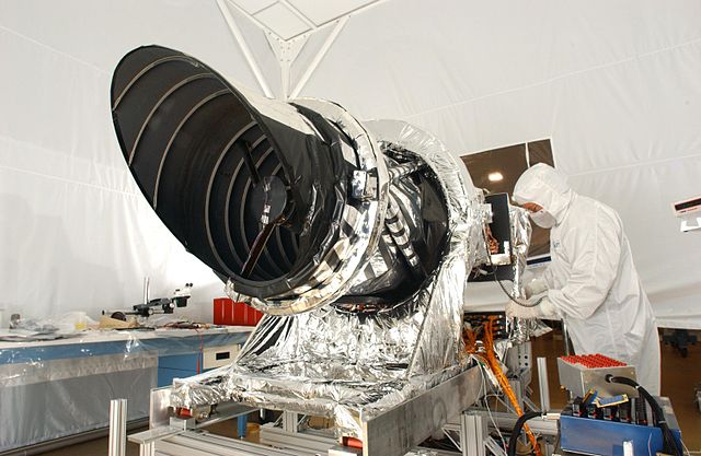
The newest Google Mars map shows individual parts of the surface with a resolution of 25-30 cm per pixel! This is due to the HiRISE camera, which is installed on the MRO satellite. The HiRISE camera is actually a telescope with a main mirror 30 cm in diameter! Despite the monstrous detail, it will take many years to fully map the planet with such a resolution, so scientists are interested in the most relevant regions of the planet and the places of operation of the rovers, of which there are now two (Curiosity and Opportunity).
Photo collection transmitted by HiRISE camera
To view in full screen mode, use the button in the upper right.
Remember that the planet's vibrant colors are due to the fact that the camera captures part of the infrared range. Images obtained using different filters and wavelengths are necessary to identify various surface features and mineral deposits.

Google Mars has given a lot of attention to Gale Crater. The new version of Google Mars shows fresh satellite images in a gray scale, so they are easy to distinguish from old ones and remember that these are not Google Mars artifacts, despite the fact that quite a lot of curious objects were discovered on the Google Mars map.
Lava tubes on the surface
Quite interesting formations are collapsed lava tubes - channels that are formed when the lava flows unevenly from the slopes of the volcano. So the virtual map of Mars allows you to watch not only well-known objects, but also quite rare geological formations. However, Google Mars maps are just high-detail images, so we recommend you Google Mars 3D maps, which convey the feeling of being on an alien planet quite well. It is especially pleasing that recently it has become possible to watch Google Mars in Russian. So the Mars Google Mars app is not only a good visualization and technology demonstration tool, but also a whole multimedia entertainment center that allows you to take exciting journeys across the red planet.
3D view
Google Mars 3D map allows not only to explore the planet, but also to make a virtual trip, because the relief map of Mars conveys the surface of a distant planet much more realistically. In 3D mode, users can enjoy the surface of the planet from a bird's eye view, as well as a 3D Google Mars map, which makes it possible to virtually navigate to the most popular objects, view the “Face on Mars” and the Olympus volcano.
This view from the Google Mars satellite was obtained using modern NASA Mars Reconnaissance Orbiter and Mars Express orbiters, as well as from the Mars Odyssey spacecraft.
A little about the planet itself
After Earth, it is practically the only place in the solar system that could shelter people. But there are many things that we must overcome on the red planet.
Orbit

The orbit of the planet "god of war" in eccentricity ranks second in the solar system. Only the orbit of Mercury has a greater eccentricity. At perihelion, it is located at a distance of 206.6 million km from the Sun, and at aphelion 249.2 million km. The average distance from it to the Sun (the so-called semi-major axis) is 228 million km. One revolution of Mars takes 687 Earth days. The distance to the Sun changes with the gravitational influence of other planets, and the eccentricity can change over time. More recently, about 1.350 million years ago, it had an almost circular orbit.
At its closest point, it is located about 55.7 million km from Earth. The planets are closest to each other every 26 months. Due to the enormous distance, a flight to Mars will take anywhere from 10 months to a year, depending on how much fuel we use.
The size

Mars is very small and the global topographic map of Mars shows that its area is very small. Mars is only 6,792 km across, about half the diameter, and only 10% of the mass of the Earth. The Google Mars Satellite Map allows you to view the planet as if you could stand on its surface. Mars, but unfortunately, does not convey to us that we would experience only 30% of the force of gravity on the surface of the Earth.
Seasons

Mars, like all planets in the solar system, has an axis tilt of about 25.19 degrees. This tilt is similar to Earth's, so it has seasons. The Martian seasons are longer than the Terrestrial ones, because the year on it is almost twice as long as the Terrestrial year. The dramatically varying distance between Mars at aphelion and perihelion means that its seasons are unbalanced.
Day
One day on Mars is only a few minutes longer than on Earth. You can adapt quickly. Another advantage is that the tilt of the Martian axis is very similar to the Earth's, it is a pity that the map of Mars online from the satellite does not show this.
Conditions

But Mars has a very inhospitable environment. Its, is only 1% of the thickness of the Earth's atmosphere. It is composed primarily of carbon dioxide. You cannot breathe in such an atmosphere. at night it can drop to -100 ° C, even at the height of summer at the equator. This interactive high-resolution map of Mars shows the huge polar ice caps at the planet's poles.

One of the most important problems is the planet's lack of a magnetosphere. Here on Earth, radioactive particles from space are deflected away from the surface, but there is no protection on Mars.
B finally, I recommend watching the popular science film Mars: Underground (The Mars Underground).
Aerospace engineer and President of the Martian Community, Robert Zubrin dreams of sending humans to the red planet in the next 10 years.
If you liked the recording, then tell your friends about it!
In order to see what the most popular places on our planet look like in stereo 3D, now you need very little. It is enough to stock up on 3D glasses (anaglyph), open Google Maps - and the world in 3D is in the palm of your hand.

To try out the capabilities of the 3D service, just go to maps.google.com and follow these steps:
- select a stick figure on the screen on the left and drag it to any of the streets
- if the street under the cursor is blue, you can release the mouse button; after that you will see a view of the surrounding area
- the image can be viewed in different directions, exploring buildings, landscapes and other objects within the vicinity
- press the "T" key on the keyboard (or select the 3D mode on context menu), after which the image will be converted to a stereo 3D format
Following Google Maps, the application “ Google earth". For those who have NVIDIA 3D Vision-enabled hardware with the latest drivers, simply launch the program. You won't find 3D settings in the Google Earth menu, so you need to make sure the 3D Vision settings are correct.
If you are the proud owner of NVIDIA 3D Surround, you can use three 3D monitors to view the map in Google Earth.
In addition, using the Google Earth application, you can create 3D images of the world's most famous landmarks, as well as just the streets of your city. Those who do not have maps installed yet can download them.

Before starting work, make sure that all markings are cleared except for the "3D building" (as shown in the picture on the left). For a more dramatic effect, it is best to choose a picture with multiple shots.
 Once you've decided on the terrain, go into full screen mode and align the image. You will be creating a stereopair, so before choosing the first (right) picture, you need to take into account that the part of the image on the right in the left picture will be cropped.
After choosing the desired location for this part of the future 3D image, copy the image (the option is available in the start menu) and save it as the right image. After that, take a photo of the left side. Generally, the closer objects are to the camera, the less you need to shift the image.
The most important thing at this stage is to move the image only in the horizontal direction, not allowing the camera to move up or down. However, this error can be corrected in the future, as opposed to zooming in or out of the camera. Sometimes it is enough just to press the "Left" key, which will allow you to move the image clearly without unnecessary displacement. However, for close-up photos, you will need to use the mouse controls.
The next step is to compose the stereo pair. Here you can download the free StereoPhoto Maker application. Unfortunately, the program menu is available only in English, but it is not difficult to understand it. Select the Open Left / Right Images item. In the window you will be asked to select first the left picture, and then the right one. After confirmation, a stereopair of selected images will appear on the screen.
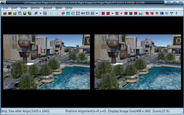
After that choose Adjust - Auto alignment. This is necessary in order to fix any alignment problems. If you are not satisfied with the results of the auto-correction, you can independently change the parallax settings by selecting the Alignment (Left) item in the Adjust menu or by pressing the "Left" key. Previously, in the Stereo menu, you must select the settings for the 3D image output (gray or color anaglyph, horizontal or vertical stereopair).
Google Maps finds the information you need. With them, you will never miss the point.
Keep driving. In any situation
Let there be no obstacles on your way. Google Maps keeps track of the traffic situation in real time, and also reminds you if you need to change lanes.

Forget about traffic jams
Google Maps keeps track of the traffic situation in real time and always suggests the best route.

Be one step ahead
Would you like to miss that treacherous convention again? Google Maps will help you! Just turn on turn-by-turn guidance and lane selection.

Move lightly
Google Maps continually checks your route against the current traffic situation and adjusts it to accommodate traffic congestion.
Make yourself at home. Everywhere
There are many interesting places in the world. And some of them are at arm's length. Let's say you are going to have a snack. Using Google Maps, you can easily find out what restaurants are nearby, you can choose the one that suits you, and then look inside and even reserve a table. Yes, it's simple!

Can't decide where to go today? Testimonials and photos from other users will help you make a decision. Do you want to tell about your favorite place yourself? ...

Walls are not a hindrance
Find out what the place you are heading looks like before you get there. Building diagrams and Street View will help you with this.
A world like you've never seen it before
Imagine that the map is not just a plan of the area. She will send you on a walk on the moon or on a trip to Mars, help you see the Earth from a bird's eye view, climb the highest mountain, descend into the lowlands and just look around carefully.

Travel to the stars
Walk the Milky Way, explore the vastness of Mars and visit the Moon. Spaceship? You won't need it.

Visit all cities in the world
Turn on satellite or street view and walk the sidewalks of your favorite cities (and cities you've only dreamed of).

The best places on the planet are for you
Thanks to the Art Project service, you can visit the Palace of Versailles, wander around the White House or explore the collection of the Tokyo National Museum at any time. And this is just the beginning!
Customize Maps to your liking
Sign in to your Google Account and customize Maps for your convenience. You can then save your home and work addresses, track where you left reviews, and quickly jump to recent searches.

Share your knowledge
Tell the world about the places you know best. Just create your own map and share it with users!

Rest your fingers
Save your home and work addresses in Google Maps so you don't have to re-enter them. In addition, you can open Maps access to the list of contacts on your mobile device - this will greatly speed up the search.

Tell us about your impressions
Leave a review about the places you have been: tell us why some are good and bad others, and at the same time add a photo. The cards will remember all your actions.
The satellite map of the world allows you to quickly move around the planet between any settlements. Detailed map of the world from satellite in Russian:
Explore the schematic map or switch to the world map from the satellite in the lower left corner of the map. Schematic map of the world Is a plan of the countries of the world and cities with street names and house numbers in Russian. The schematic map of the world shows sights and tourist attractions, the location of train stations, shops, restaurants and shopping centers, a map of the city's highways. Satellite map of the world will allow you to view satellite photos of the city thanks to images from the Google Maps service.
You can zoom in on the online map by scaling it to streets and house numbers. To change the scale, use the “+” (zoom in) and “-” (zoom out) icons located in the lower right corner of the map. You can also zoom in or out on the map using the mouse wheel. The left mouse button zooms in on the map, the right mouse button zooms out. With the mouse, you can move the interactive map in all directions by grasping any place on the map with the left mouse button.
Interactive world map online is a very convenient and modern travel guide for exploring the city, its districts and attractions, hotels, places of recreation and entertainment. An online map of the world can not become an indispensable assistant for you in your independent travel. The interactive map is provided by Google Maps.
How satellite maps of the world are created:
The satellite, passing over the planet, scans the earth's surface and maps are made using software. More recently, several years ago, satellite maps showed the planet's surface from a height of several kilometers. Now technologies allow making satellite maps from a height of several meters, and in the near future technologies will make it possible to create satellite maps with details of up to 30 centimeters.
What to see on the satellite map of the world:
First of all, people look for their country, their hometown, street and house in which they live on the map. To do this, you can zoom in on a schematic map of the world to your city, and then turn on the "Satellite" mode in the lower left corner of the map. In the same way, you can travel to all countries of the world online, exploring the sights of countries and cities in real time. Popular places that are often searched for on a satellite map: Reichstag in Berlin (Germany), Athenian Acropolis in Greece, Egyptian pyramids, Italy - Colosseum in Rome (Ancient Roman gladiatorial arena, Peterhof in Russia (west of St. Petersburg), Statue of Liberty in the USA - the symbol of America, the Eiffel Tower in Paris (France), the Great Wall of China.