Mystery of Naska desert. Plateau Nask
Read also
What only miracles do not keep an ancient story in yourself! How many secrets are not yet solved, and how many of them never solve! However, walking into the future, people all deeper understand the past and replace guesses and myths of real history. So, it is believed that archaeologists have already finally allowed a riddle, which Tailed the Desert of Naska. The outskirts of Peru became famous in 1947, when the first scientific publications about incomprehensible lines and mysterious drawings appeared. Later, the idea that was the runway of the aliens. Many residents of the planet were perceived such an idea with interest. So the myth originated.
Mystery geoglyphs
Scientists and amateurants have tried to explain the origin in the desert of geometric patterns that occupy the area almost 500 square kilometers. Although at first glance, the story of their occurrence in southern Peru is quite understandable. The desert of Naska for several centuries served for the ancient Indians canvas, for which they for some reason applied mysterious signs. On the surface there are dark stones, and if they are removed, light sedimentary rocks are exposed. Such a sharp color contrast and used Peruvians to create geoglyph drawings: the background for images served as the dark color of the soil. The desert areas they decorated with straight lines, trapezes, spirals and huge animal figures.

Desert Naska. Coordinates of drawings
These signs are so huge that you can only see them from the plane. However, everyone who wants today can admire the mysterious symbols without leaving the house, it is enough to run on the computer any program demonstrating satellite images of the Earth. Coordinates of the desert - 14 ° 41 "18.31" S 75 ° 07 "23.01" w.
In 1994, unusual drawings were included in the list of monuments that constitute the world cultural heritage. And then the whole world found out where the desert of Nask is located. People wondered who was the mysterious gallery. Are the gods in the sky, reading human souls? Or maybe in this ancient country, aliens built a cosmodrome ever, so there was a markup? Or is it the first tutorial on astronomy, where is the move of the planet Venus personifies the wing of some bird? Or maybe these are family signs that the clans marked the territory populated by them? It was even suggested that this way the Indians denoted the flow of underground streams, allegedly this is a secret map of water sources. In general, the hypotheses existed a great set, the best minds competed in the interpretation of the meaning of the inscribed, but no one was in a hurry to pick up the facts. Almost all assumptions were built speculative - to go to unfortunate distance rarely who decided. That remained the desert of Naska (photo below) by one of the most mysterious places of the planet, and its ancient residents are one of the most interesting cultures of Precucumbian America.

Path to Ripping
From 1997 to 2006, scientists of various areas of knowledge were conducted in the Peruvian desert a careful study. The facts that were collected by them, completely milked all the explanations of esoterics. No space secrets left! It turned out to be quite the earthly desert of Naska. Her drawings also talk about the earthly, even too earthly. But first things first.
Expedition in Peru
In 1997, the expedition organized by the German Archaeological Institute began to study geoglyphs and culture of Naska residents in the vicinity of the village of Palpa. The place was chosen based on the fact that it is in close proximity to the villages, where the ancient Indians lived. "To understand the meaning of the drawings, it is necessary to prepare in people who created them," the scientists said.

Landscape study
Within the framework of the project, the climatic features of this area were studied. This has clarified the origin of the characters. Earlier, on the spot, where the Nask desert is now spread, there was a smooth steppe site. It was formed from the basin, sharing Andes and the coastal Cordille (another mountain range). In the time of the Pleistocene, it was filled with sedimentary rocks and a pebble. So the perfect "canvas" appeared to apply all sorts of drawings.
Palms grew here a couple of millennia ago, Lama grazed, and people lived, as in the Garden of the Garden. Where today the desert of Naska stretches, even strong shower and sweats happened before. But about 1800 BC. e. The climate has become significantly land. The drought lifted the herbal steppe, so people had to be rid of the valleys of rivers - natural oasises. But the desert continued the offensive and came close to the mountain ranges. With 20 kilometers to the Andest of the Andest Territory, the Indians were forced to go into mountain valleys located at an altitude of 400-800 meters above sea level. And when the climate has become still land (about 600 g. New era), the culture of Nask and disappeared at all. There were only mysterious signs from her on earth. Thanks to the extremely dry climate, they remained millennia.

Desert Naska. Pictures
After having studied the wednesday of the creators of mysterious geoglyphs, the researchers were able to interpret them. The earliest lines appeared about 3,800 years ago, when the first settlements arose in the city of Palpa. Southern Peruvians their "art gallery" created outdoors, among the rocks. They cut down and scratched various patterns, chimer and people, and animals on brown-red stones. "The revolution in art" occurred in the Peruvian desert somewhere in 200 BC. e. Artists who previously covered the pictures of only rocks, took apart by the greatest cloth, given to them by nature itself, - extended before the gaze. Here masters were where to turn around. But instead of figurative compositions, the arters have now preferred lines and geometric pieces.
Geoglyphs - part of the ritual
So why did these signs create? It is definitely not for us to admire them today. Scientists believe that the drawings were part of the "sanctuary", these are so-called ceremonial figures that have a purely mystical meaning. Geophysics investigated the soil along the lines (their depth is almost 30 centimeters) and revealed that it is very sealed. 70 geoglyphs depicting some creatures and animals are significantly wrapped out, as if there were crowds of people here. In fact, there were various festivities related to the cult of water and fertility. Than the plateau became land, the priests more often performed a magical ceremony in order to call on the rain. Of the tenstairs and lines, nine are treated towards the mountains, where the saving sediments came from. Magic helped for a long time, and cloud-carriers were returning. However, in 600, the new era gods completely accepted the people who settled in this edge.

Debate myth
The greatest drawings in the Naska desert appeared at the time when it rains almost stopped. Most likely, people asked the harsh Indian God to ride their sufferings, they hoped that at least such signals would notice. But God remained deaf and blind to the plea. The rains did not go. In the end, the Indians left the native land and went to look for a flowering country. And after a couple of centuries, when the climate became softer, the desert of Naska has gained residents again. There were settled people who did not know anything about the previous owners of these lands. Only the lines left the distance on Earth reminded that once a man tried to speak with the gods. However, the meaning of the drawings was already forgotten. Now only scientists begin to understand the reason for the emergence of these writing - huge signs, ready, it seems to survive eternity.
Naska desert is located in the Department of ICA in the south of the country of Peru, between the Rivers of Inhenio and Naska. This territory is 500 square kilometers covered with huge images of people and animals, lines, spirals and geometric shapes, the size of which reaches up to 300m in length. These signs are so huge that you can only see them from the plane. However, everyone who wants today can admire the mysterious symbols without leaving the house, it is enough to run on the computer any program demonstrating satellite images of the Earth. Coordinates of the desert - 14 ° 41 "18.31" S 75 ° 07 "23.01" w.
The mystery of Naska desert was discovered in 1927, when the Peruvian pilot, flying over the desert valley in South Peru, saw that the Earth was drawn by long lines and painted with animal images. Such geometrical drawings appeared on the Naska plateau even during the Naska civilization. It is believed to dokolumbovy civilizations, II-IV century BC.
Geoglyphs are a big riddle, because it is not known to anyone why representatives of the disappeared ancient civilization of the Indians drew huge paintings, distinguishable only from the air. The images are imprisoned on the scanty rocky soil of the desert. At first glance, they are little distinguishable and are chaotic plexus of lines spent on someone on the reddish surface of the desert, but from the height of bird flight this chaoticism acquires meaning.

Despite the fact that geoglyphs were opened in the last century, the appointment of these amazing drawings is still unknown. Researchers A. Krebs and T. Mexium consider them part of an ancient irrigation system. T. Mexium also later also later suggested that the images are connected with the holy trop of the Inca. Some signs, for example, chilms from stones at the intersections of lines, indicate that the figures were used in rules.
P. Kozzov, who visited Naska Valley in 1941, drew attention to the special role of lines in the rays of the setting sun during the summer solstice and called these lines the largest textbook of astronomy. In the future, this theory in its studies was developed by the German researcher M. Riete. In her opinion, some of the geometric shapes symbolize constellations, and animal images - the location of the planets.

The study of astronomy for ancient civilizations was a great meaning. Among other things, it also had a practical function - helped to predict rain periods important for agriculture, but the archaeologist H. Lanko expressed a consideration that the drawings are cards indicating the path to vital places, for example, to underground water sources.
The most incredible and at the same time the most popular theory belongs to the famous Swiss researcher Erich von Danikin. He suggested that the images are nothing but a markup on the earth's surface for aliens from other planets.

No less surprising and other hypothesis, according to which representatives of the ancient civilization of Naska mastered the airplane, which is why the drawings are distinguishable only from the height. In confirmation of this theory, several dark spots, which are available on the surface of the plateau, are interpreted as footprints on the playgrounds for balloons. In addition, the Pottery products of the Indians of the Nari have patterns that resemble balloons or snakes.
The accurate age of geoglyphs is unknown. According to the results of archaeological studies, the images were created in different periods. The very first, the most straight lines arose, probably in the sixth century BC, the latest - animal drawings - in the first century of our era.

Scientists have proven that the figures were created manually. The drawings were applied to the surface of the desert in the form of a groove in 130 cm wide and 50 cm deep. On dark soil line form white stripes. Since light lines are heated less than the surrounding surface, the difference in pressure and temperatures arises, which leads to the fact that the lines do not suffer during sand storms.
Who and why painted in antiquity on the surface these pictures, distinguishable only from a high height, still remains a mystery. A huge number of theories were put forward, but none of the time has received scientific confirmation.
The Naska Desert is one of the most amazing and at the same time mysterious. Archaeologists, mythologists and historians still can not understand where huge drawings and lines appeared on her plateau. At one time, they produced a real exterior and a cross in the scientific sphere. Many tourists ride in order to look at such amazing drawings in the Naska desert. It is not for a walk by her fee, but if anyone still decides, it will stay at its territory no more than two hours.
Geoglyphs of the desert Nask
In 1939, flying over the desert plateau, the archaeologist Paul Kosovo remarked strange lines and unusual drawings. He reported this to the whole world and made a whole stir. The drawings in the Peruvian desert Naska studied a large number of scientists, but everyone was bred by their hands, trying to answer the question where they appeared from. There were many options: aliens, believers or winds left them, but the arguments of other scientists were questioned. The mystery of mysterious drawings is still not disclosed, it is shrouded in legends and theories.
In the Peruvian desert, Nazca placed more than 30 geoglyphs with the image of different animals and insects, lines and triangles, etc. To fully see them is possible only rising in the sky.
Excursions in the desertTo see the mysterious drawings on the desert plateau of Naska - the business is costly, but possible. There are five tourist firms that every day collect small excursion groups. Over the Peruvian Desert Naska takes place on parflala or on a small plane. Flight cost - 350 dollars. Regarding the excursion it is worth contacting 2-3 days, because the number of passengers by plane is limited (5 people), and those who want a large number. In the agency you can also agree on watching a desert gallery by helicopter. Naturally, this pleasure will fall out in a huge amount - 500-600 dollars.
The desert excursions are carried out mainly in December, when the air temperature decreases to +27 degrees. Over the past few months, it is almost impossible to be on it. Before going to the excursion, you need to get rid of it. Choose clothes with light, out of lightweight material, closed shoes with a dense sole and a headdress with wide fields.
Where is the desert of Naska?
The desert of Naska in Peru is 380 km from. If you are traveling on, then to get there, you need to choose a 1s highway, which is not far from the Pacific Ocean. From Lima you can get to the desert with
Peru. Mystery of the desert Naska revealed?
A naska desert known to the whole world with its mysterious drawings, lines and geometric shapes is located in the south of Peru, 400 km from Lima and 50 km from the Pacific coast. This is one of the most arid places on our planet, there falls only about 2.5 cm of precipitation per year - less than in the Gobi desert.
Opening of the drawings of the desert of Nask
Mysterious lines and Nasce drawings were accidentally open during the flight by the Peruvian pilot in 1927. The first was trying to reveal the mystery of the desert Naska an American archaeologist Paul goats, who arrived in a nask in 1939. It was found that the gigantic drawings were performed using the removal of a 20-centimeter layer of brown, burned stones and soils, under which a much brighter soil was hidden.
Giant Astronomical Calendar?
All drawings could be divided into three groups: in one - geometric shapes, in another - line, zigzags and spirals, in the third - giant images of birds, insects and animals. The goat floor put forward a hypothesis that the Nauki drawings were a giant astronomical calendar. This idea came into his head when he saw that on the day of the summer solstice the sun sank right outside the end of one of the straight lines included in the huge drawing of the bird.
The study of the goat continued his assistant - German mathematician Maria Riete. It can be said that this tireless woman devoted the whole life of the Naska desert and confirm the hypothesis of his gentleman of the goat. For more than 40 years, Rayhe was the catalog of lines and drawings, measurements made measurements and even conducted aerial photography using the Peruvian Air Force. A research researcher in 1992 was died, until the end of his life she believed that the NABI lines were a gigantic astronomical calendar.
1968 - an unexpected hit on the hypothesis of Kozo and Rayhekh was inflicted by American astronomer Gerald Hawkins, who analyzed the Lines of Nasky with the help of a computer and made conclusions that 80% of the geometric figures have nothing to do with the movement of heavenly bodies - as J. Hawkins became widely known After the release in 1965, his books "Rage Stonehenge", in which he argued that the famous building of the ancients in England was a kind of observatory, his opinion for many turned out to be decisive.
But, as Maria Rayhek rightly considered, when calculating in his study, Hawkins did not take the relief of the terrain, this led him to an erroneous conclusion. Today, many of the researchers do not exclude that part of the lines in one way or another is associated with the astronomical observations of the ancient inhabitants of the Nari, although skeptics say that some of the almost 1000 straight lines some surely can just point out the heavenly luminaries in certain days.
Giant map of the propagation of groundwater?

Comparatively not so long ago, a message appeared in the foreign press that the mystery of the Nauki drawings was finally disclosed. The author of the new hypothesis became David Johnson, a former teacher of Higher School from New York. Interestingly, Johnson was absolutely not interested in the mysterious figures of the NAKI, and was looking for water in this desert with such an exotic method as a climbing. In particular, Johnson attracted ancient irrigation channels, in some of them water still flowed.
Local residents told him that two small rivers were the main sources of water for the canals, but Johnson immediately noticed: the channels go parallel to the rivers and could not take water from them. Soon he came to the conclusion that the sources of water were geological faults. Water flowing from the Andes was accumulated in the zones of cracks in the indigenous breed and on the ruins under the ground went down, in the valleys.
At first, Johnson did not associate this idea with the Lines of Naski, but began to notice that, as soon as he detects aquifer layers, there are also traces of the ancient inhabitants of the desert and their geometric patterns. Once in July 1996, he climbed one of the hills, looked at the two wide lines stretching to the horizon, resting in the dark clefts of the nearest mountains, which he considered educated geological faults, and then it was sore. As Johnson told, he sat down at the top of the hill and said himself: "My God, I know that they denote the lines of the Nari, they trace the surfaces of the groundwater sources!" Speaking differently, lines and geometric shapes on the surface of the desert are a giant map of the propagation of groundwater.
Although some of the scientists have long assumed that the Pictures of the Nasky to one degree or another are associated with water, the main jewel of these arid places, many of them reacted to Johnson's idea skeptically. But Helyin Silverman, an archaeologist from the University in Illinois, in 1999 at a conference dedicated to Nask, still asked her colleagues to "keep his eyes open" while there is a test of Johnson's hypothesis.
Johnson's hypothesis has been checking Steve Mabi, a hydrogeologist from a university in Massachusetts for several years. "We make cards of our aquatic streams, maybe people of the Nazi did the same thing, only" dragged "them on the earth's surface," said Maby. He has already found evidence that alternative water sources in faults that Johnson found, in reality exist. And in all cases, Maby installed "marking" of these faults with lines on the surface.
Nasky lines are related to sacred rituals?


Johann Reinhard, anthropologist, first put forward the version that the Nasce lines are connected with the sacred rituals that are devoted to the rain. He discovered a ritual capable of explaining the lines of the Nari. Archaeological finds in some of the wide lines ("Danikin's" landing bands "confirm their connection with water. Sea shells were found (water symbol in Andes) and drinking ceramic vessels. Reinhard also sees sacred symbols in animal images, so spider and monkey in these places were considered knitted with fertility, and hence with water.
Another of the researchers, Entos Aven, believes that he has already opened the hidden logic in the mosaic of the Lines of Nasks. He removed from the map of the image of all animals, spirals and geometric shapes and left one straight lines on it. It turned out that all the lines converged in the sun-like patterns, which he called "radiation centers." Together with the colleague, he was able to highlight 62 beam center and about 800 straight lines. In fact, each of the "radiation centers" accounted for the top of some hill. According to Aven and some experts, the lines could serve in paths and led people to the tops of the hills ("radiation centers"), where they conducted rituals associated with water.
The riddle of the desert Naska is trying to reveal other researchers. It was established that the ancient macans flawed their enemies, mummifying their heads, and had very curious religious ideas about the nature and the surrounding world. On the ceramics of the Naski, images of animals are almost identical to giant drawings in the desert.
Markus Rainel decided to go through the uncomfortable path and elected another point of reference: "If we want to decipher Naska's geoglyphs, we need to find people who created them."
Archaeological expeditions
Rainendel conducted a surface examination of the mountainside in the vicinity of the town of Palpa, 40 km from Nasi, and at a depth of 30 cm found there the top of the wall there. Excavations confirmed that these are the walls of an ancient city, which was located in close proximity to the legendary drawings.
After the first expedition, the archaeologist drawn a detailed plan of the city and restored some of his history. 1900 years ago on the flat part of the valley, in the Rio-Grande rivers, Rio-Palp and Rio-Wischas rivers, there was a strange building - the settlers built a wall of 400 m in length and 100 m wide. Material walls made of brick blocks rose to a height of 12 m symbolizing power and wealth. The basis of the wealth of the "People of Nazka" was agriculture that flourished due to an extensive irrigation system.
Excessive agricultural products created conditions for such a social bundle of society, in which some segments of the population did not participate directly in the production of food. Rainendel believes that they had a kind of nobility - the highest public layer. An indirect confirmation of this assumption can be a complex system of irrigation channels, for the construction of which it was necessary to competent planning and management of work.

And to create drawings in the desert, orders, plans and management on the part of the rulers of the rulers were also needed, no matter how they were called - kings, leaders, supreme priests or somehow else. Rindelia plans are covered with lines, triangles and spirals, reaching almost to the settlement.
The German archaeologist is looking for the original meaning of mysterious drawings of Nask in the Rio Grande River Valley. The former inhabitants of these places "inhabited" the surrounding cliffs with thousands of images of various animals and human-like creatures. Small images knocked on the rocks (petroglyphs) date back to the IV century BC. e. Late them were repeated in an enlarged form on the flat surfaces of the mountain slopes. The drawings of the value from 10 to 20 m was clearly seen from afar.
"It was from here that the tradition of terrestrial drawings should have developed," Reinendel suggested. - As they increase, they became increasingly swallowed and abstract and no longer rocky slopes, but the extensive surfaces of the deserted plane oil. "
The reasoning of the scientist is very logical, but the question arises: why these gigantic schematic drawings are in such places where no one can consider them? In addition to the previous "cosmic" interpretations of NASK drawings, you can bring another hypothesis after perennial observations in the basins of the nearest rivers American David Johnson made an unexpected conclusion: "Naska lines are clear text carved on the ground to specify the inhabitants of the region where available sources are available water".
Marcus Raindel has not yet have reason to refute or confirm this and other hypotheses. It imposes all hopes for the next seasons of excavations and intends to get to the individual buildings lying away from the settlement - right on the continuations of the helmet lines or directly under them. Archaeologists have not yet found such buildings. Excavations inside with fenced walls of the territory will also be continued: Raindel wants to find the temple of Naska people. The next stage will be the search for the creators of NASK lines, and the ultimate goal is the rays of mysterious signs.
In our opinion, it would be necessary to consider all these hypotheses in the complex. After all, many of the scientists may probably be right. Some lines of Naski can serve as an astronomical calendar that celebrates the periods of the greatest drought or rains, others - serve as ceremonial trails for rituals related to the challenge of the rain, the third - design on the surface of underground aquifers. All the lines together and created the most real puzzle for scientists ...
An explanation of the giant images of animals, birds and insects, in our opinion, may be even easier. Can you see spider or hummingbirds with a high hill? Unlikely. This was also understood by the ancient inhabitants of the Nazi, only interested in their rain clouds, which rushed over them at a huge height. For the heavenly deities controlling the rains, and these gigantic images are intended to see them and clenched over the animals, drinking them, and at the same time and the people, lively moisture. Is it a raidness of mysterious signs of the Nari?
Do you know what Naska is? This is an ancient Indian civilization. It received its name from the river, in the valley of which to date you can admire the numerous monuments of culture. The flourishing of this civilization was observed in the first millennium to our era. Later, Nask's name was a small Indian village in the south of Peru, located behind the mountain ranges. In order to get to her from the capital of the state of Lima, it was necessary to drive a lot of kilometers along the dusty located in the rocky and sandy empty.
Today and the city of Naska connects a four-row motorway. Moreover, it is part of it, which passes through the bare hills and the desert, paved with wild stones. Little and quiet in the past village today is a small, but very accurate town. There is a private museum and a small park, various shops and even two banks. There are in the town of hotels in various classes that take tourists who went to this terrain in order to familiarize themselves with the world's famous "Pampo de Naska".
Geography
What attracts tourists from around the world a small town in the south of Peru? Travelers go here in order to look at the amazing and mysterious plateau of Nask. This is a plain located on some elevation. For her, as for all the plateau is characteristic, even, and sometimes a wavy relief. In places it happens slightly dismembered. From other plains, the plateau separate distinct ledges.
Where is Naska? Located this plateau in the south of Peru. From the capital of the country of Lima, it is separated by 450 km, which must be overcome in the southeastern direction. The map is located almost in the coastal zone of the Pacific. From the plateau to its endless water - no more than eighty kilometers.
The coordinates of Naska will help to find this locality on the map. They make up 14 ° 41 '18 "southern latitude and 75 ° 7' 22" Western longitude.
Plateau Naska has an extended form from the north to the south. Its length is 50 km. But the width of the terrain from Western to Eastern borders ranges from five to seven kilometers.
Natural conditions
The coordinates of Nasca are such that the area is located in the dry climate area. In this regard, she is Malonaselen. Winter here lasts from June to September. For us, it is surprising, but in the southern hemisphere it does not coincide with the one that is characteristic of the zone located north of the equator.
As for the air temperature, it is practically stable in this area. In the winter months, its value is not below sixteen degrees. In the summer, the thermometer column almost constantly keeps at +25.
Plateau Nask, as mentioned above, is in close proximity to the waters of the Pacific Ocean. However, despite this, rains here are a big rarity. None on the plateau and wind, since it is protected by mountain ranges from the air masses. There is also no rivers and streams in this desert. You can see here only their dried beds.
Lines of Nask.
However, numerous tourists in this edge attracts not its location. Plateau Nask manits mysterious drawings and lines located right on the earth's surface. Scientists call them geoglyphs. This concept means a geometric shape performed in the earth's ground, which is at least four meters long.
The Geoglyphs of Nask are grooves from a mixture of sand and pebbles, processed in the soil. They are not deep (15-30 cm), but long (up to 10 km) having a different width (from 150 to 200 m). Geoglyphs, or, as they are also called, the NASK lines are made in very bizarre. Here you can see the outlines of birds, spiders and animals, as well as geometric shapes. In total lines on the plateau about 13 thousand.

What is it? Secrets of stories? Riddles of the past? There is no unambiguous answer to these questions. Some scientists believe that the drawings of Naska are applied to the earth's surface by skillful human hands. However, it is not possible to confirm such an assumption. There is another, quite a steady opinion, according to which, stripes and lines were not applied by people, but by representatives of the alien reason. This is the greatest secret of the desert Nask, over which dozens of scientists are fighting. However, despite this, the puzzle of the Peruvian Plateau remains underestimated for the modern world.
History opening
The desert of Naska (Peru) is known for huge paintings located on the plateau. These drawings, created by unknown creators, belong to the greatest achievements of world culture and are an undoubted monument to the art of our entire planet.
For the first time, terrestrial gigantic paintings noticed pilots in 1927. But the scientific community of the Geoglyph of Naska became known only twenty years later. It was then that the American historian Paul Kosovo published a whole series of photographs of amazing and mysterious drawings, which were made from the air.
Technology of creation
Pictures of Naska are designed when removing debris, brown stones and volcanic pebbles, covered with a thin blackfold of black, with a bright subsoil consisting of a mixture of calcite, clay and sand. That is why the contours of gigantic figures are clearly visible from the board of the helicopter or aircraft.

From the air all lines on the background of the soil look more brighter, although from the ground or with low mountains such drawings merge from the ground, and it is impossible to distinguish them.
Lines and geometric shapes
All images that can be observed in the Naska desert have a different form. Some of them are stripes or lines whose width is located from fifteen centimeters to ten or more meters. Such soil deposits are quite long. They can reach from one to three and even more kilometers. Strips can also smoothly expand at their length.
Some Lines of Nask are elongated or truncated triangles. This is the most common view of the plateau. And the sizes are the most diverse and are in the range of one to three kilometers. Such triangles are often called trapezoids. Some drawings of Nask are large platforms that have a rectangular or incorrect form.
You can see such familiar to us from the geometry of quadrangles as a trapezoid (with two parallel sides) on the plateau. These creations with clear forms in the desert are the order of seven.
Many lines and platforms have some dug-shaped profile to thirty or more centimeters. Moreover, all these grooves have clear boundaries resembling a border.
Feature of lines Nask
The geoglyphs of the Peruvian desert were widely known due to their rectineality. The imagination of travelers literally affects the lines stretching on a lot of kilometers on the plateau, without difficulty overcoming all the features of the relief. In addition, the figures of Naska have peculiar centers, located, as a rule, on elevations. At these points, various types of lines are converging. Often, the deepening in the ground is connected to each other, uniting in the various combinations. It happens that the shapes and lines cover each other.
Interesting is the location of the trapezoids. Their bases are usually rotated on the side of the river valleys and are located below the narrow part.
Surprisingly what:
- the edges of all lines have the highest accuracy, the scatter of which is within only five centimeters for a length of several kilometers;
- the visibility of contours is preserved even when attaching figures on each other;
- there is a strict limitation of figures in width with significant strip lengths;
- the visibility of the strips is preserved even with changes in the characteristics of the soil;
- there is a similarity of the configuration and the location of the radiating figures with optical schemes;
- the geometry of figures is maintained even with complex relief;
- there are lines wearing an astronomical character pointing to the sides of the light or the days of equinox.
Diverse drawings
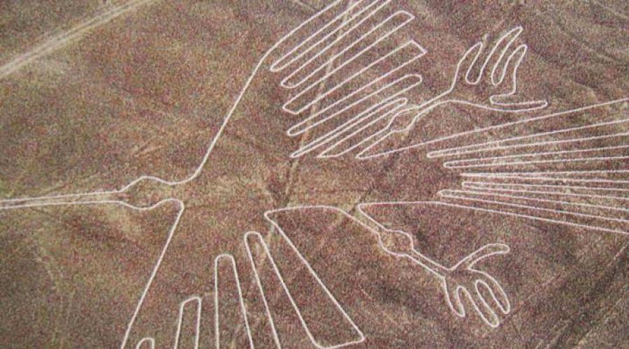
A peculiar decoration of large-scale platforms of Nask are zigzags and tight-shaped figures. Among the 13,000 lines, 800 sites and hundreds of various spirals in the amazing and mysterious Peruvian desert you can see the semantic drawings. These are three dozen figures of animals and birds, including:
- lizard 200 meters long crossed by the ribbon of the American highway, the builders of which did not notice the drawing;
- bird with a snake neck stretching 300 m;
- stater Condor;
- eighty meter spider.
In addition to these images, you can see fish and birds, a monkey and flower, something similar to a tree, as well as a thirty-meter figure of a person, made at all on a plateau, but as if knocked out on one of the steep mountains of the mountain.

From the ground, all these drawings are nothing different, as separate strokes and stripes. You can admire the gigantic images, only rising into the air. These greatest secrets of history, the riddles of the past still did not find their explanations from scientists. As an ancient civilization that does not have aircraft, was able to create so complex drawings, and what are their purpose?
Features of the drawings of Nask
The contour images of birds and animals have various sizes in the range from 45 to 300 m. The width of the circuit line of the drawings is from 15 cm to 3 m. All semantic images that can be seen on the plateau of Nask, focused on its edge over the river valley Inherio.
Among the features of these drawings can be allocated:
- implementation of one continuous, non-intersecting and non-closing line;
- the beginning and end of the deepening of the soil are located on the site;
- "Output" and "entry" of contours are two parallel lines;
- there is an ideal interface between the curves of drawings and direct, which, as established by scientists, are made according to the strict laws of mathematics, which explains their harmony and beauty;
- mechanical execution (except the image of a monkey), which deprives the figures of animals of any emotional color;
- the presence of asymmetry, which is explained by the imperfection of work on the increase in sketches;
- the presence of secant lines parallel to one of the contour segments, which is explained by the complex implementation of the internal space of the figure.
Assumptions and versions
Who is the author of amazing creations in the desert of Nask? While scientists can only build their versions and put forward various hypotheses. So, many supporters at the assumption of extraterrestrial origin of geoglyphs. They suggest that wide lines served for an extraterrestrial civilization with landing stripes. However, such a hypothesis is a lot of opponents, which put forward their very weighty argument - the character of the drawings. Yes, they have impressive and far from earthly sizes, but their plot suggests that they are fulfilled by people, and not aliens at all.

However, in this case, there are many unresolved mysteries. How did the masters unknown to us be able to create such gigantic images that are only visible from the air? Why did they do it? What techniques used to preserve the proportions of giant models?
The hypothesis about the occurrence of drawings on the plateau of Nazk is varied, and some of them are just fantastic. However, there are among existing versions and such that deserve special attention.
So, according to some scientists, the entire system of Nask lines is a huge calendar. One of the first to put forward this assumption Paul Kosovo. This American scientist was the first one who opened the mysterious jourge of a variety of forms and lines. After that, his whole life was devoted to the rays of the mystery of the Peruvian Desert. One day, Kosovo noticed that the setting sun village directly at the intersection of the horizon with one of the straight lines. They were also discovered and the band indicating the winter confrontation. There is also an assumption of Kosovo that certain drawings correspond to one or another cosmic bodies. Such a hypothesis existed for a long time. Moreover, it was supported by many well-known scientists from around the world. However, it was later proved that the percentage of NASK drawings with certain planets is extremely small to consider this calendar system.
There is another very plausible version. According to it, NASK lines indicate the location of the extensive system under the ground of water channels. The confirmation of this hypothesis can serve as the fact that the location of the ancient wells coincides with the strips diverted in the ground. But it is possible that this is just a simple coincidence.

Or maybe the purpose of the lines of NASK is a cult character? The excavations of archaeologists found in places of drawings an ancient human burials and altars. However, all ritual objects have always been erected in such a way as to cause certain emotions and affect the person. The pictures, viewed only from the height, no feelings for those who are on Earth do not cause.

Whatever it was, the one who created these amazing figures was able to somehow move through the air and was wonderful oriented in space. Maybe the ancient people knew how to build balloons and flew to them?
All existing hypotheses have not yet brought up humanity to the rays of the mystery of Naska desert. Maybe soon scientists will answer the question of the origin of amazing lines? Or maybe this mystery remains unsolved ...