Lithosphere and earth bark. Geography
The characteristic feature of the evolution of the Earth is the differentiation of the substance, the expression of which serves as the shell structure of our planet. Lithosphere, hydrosphere, atmosphere, the biosphere form the main shells of the Earth, characterized by the chemical composition, power and condition of the substance.
The inner structure of the Earth
Chemical composition of the Earth (Fig. 1) is similar to the composition of other planets of the earth group, such as Venus or Mars.
In general, elements such as iron, oxygen, silicon, magnesium, nickel prevail. The content of light elements is small. The average density of the substance of the Earth is 5.5 g / cm 3.
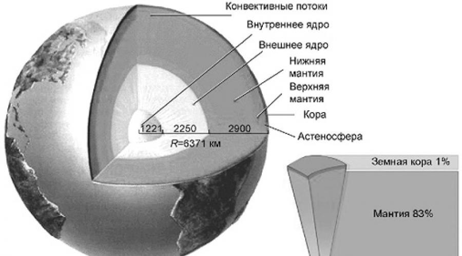
The internal structure of the land of reliable data is very little. Consider Fig. 2. He depicts the internal structure of the Earth. The earth consists of the earth's crust, mantle and core.
Fig. 1. Chemical composition of the Earth

Fig. 2. The internal structure of the Earth
Core
Core (Fig. 3) is located in the center of the Earth, its radius is about 3.5 thousand km. The kernel temperature reaches 10,000 K, i.e. it is higher than the temperature of the outer layers of the Sun, and its density is 13 g / cm 3 (compare: water is 1 g / cm 3). The core presumably consists of iron and nickel alloys.
The external core of the Earth has a greater power than the internal (radius of 2,200 km) and is in a liquid (molten) state. The inner core is susceptible to colossal pressure. The substances that lay it are in a solid state.
Mantle
Mantle - The geosphere of the Earth, which surrounds the kernel and is 83% of our planet (see Fig. 3). The lower an annilateral is located at a depth of 2900 km. Mantle is divided into a less dense and plastic top (800-900 km), which is formed magma (translated from Greek means "thick ointment"; this is the molten substance of the earth's subsoil - a mixture of chemical compounds and elements, including gases, in a special semi-liquid state); And the crystal lower, tire about 2000 km.

Fig. 3. The structure of the Earth: the core, mantle and earth
Earth's crust
Earth's crust - The outer shell of the lithosphere (see Fig. 3). Its density is about two times less than the average density of the Earth, 3 g / cm 3.
From the mantle of the earth boron separates Border Mochorovichich (It is often referred to as the moss boundary), characterized by a sharp increase in the rates of seismic waves. It was installed in 1909. Croatian scientists Andrey Mohovichichich (1857- 1936).
Since the processes occurring in the upper part of the mantle affect the movement of the substance in the earth's crust, they are combined under the general name. Lithosphere(Stone shell). Lithosphere power ranges from 50 to 200 km.
Below the lithosphere is located Asthenosphere - Less solid and less viscous, but more plastic shell with a temperature of 1200 ° C. It can cross the border of Mokho, embedded in the earth's bark. Asthenosphere is a source of volcanism. It contains the foci of molten magma, which is embedded in the earth's bark or poured onto the earth's surface.
The composition and structure of the earth's crust
Compared to the mantle and the core, the earth's crust is a very thin, rigid and fragile layer. It is composed of a lighter substance, which currently discovered about 90 natural chemical elements. These elements are not equally represented in the earth's crust. On seven elements - oxygen, aluminum, iron, calcium, sodium, potassium and magnesium - accounting for 98% of the mass of the earth's crust (see Fig. 5).
A peculiar combinations of chemical elements form various rocks and minerals. The age of the most ancient of them has at least 4.5 billion years.

Fig. 4. The structure of the earth's crust

Fig. 5. The composition of the earth's crust
Mineral - It is relatively homogeneous in its composition and properties of the natural body, sampled both in depths and on the surface of the lithosphere. Examples of minerals are diamond, quartz, gypsum, talc, etc. (the characteristic of the physical properties of various minerals can be found in Appendix 2.) The composition of the earth minerals is shown in Fig. 6.

Fig. 6. General mineral composition of the Earth
Rocks Consist of minerals. They can be designed both from one and from several minerals.
Sedimentary rocks - Clay, limestone, chalk, sandstone, etc. - formed by precipitation of substances in the aquatic environment and on land. They are laying. Geologists refer to their pages of the Earth's history, as it can be found about natural conditions that existed on our planet in ancient times.
Among sedimentary rocks, organogenic and non-naigneous (chip and chemogenic) are distinguished.
Organogenic Mountain breeds are formed as a result of the accumulation of remains of animals and plants.
Chip rocks It is formed as a result of weathered, psswing with water, ice, or wind products of destruction of previously arising rock rocks (Table 1).
Table 1. Chip rocks depending on the size of the debris
|
Breed name |
Babr size con (particles) |
|
More than 50 cm |
|
|
5 mm - 1 cm |
|
|
1 mm - 5 mm |
|
|
Sand and sandstone |
0.005 mm - 1 mm |
|
Less than 0.005 mm |
Chemogenic Mountain breeds are formed as a result of sedimentation of the seas and lakes dissolved in them substances.
In the thickness of the earth's crust from magma are formed Magmatic rocks (Fig. 7), for example, granite and basalt.
Sedimentary and magmatic rocks at high depths under the influence of pressure and high temperatures are subjected to significant changes, turning into Metamorphic rocks. So, for example, limestone turns into marble, quartz sandstone - in quartzite.
In the structure of the earth's crust, three layers are distinguished: sedimentary, "granite", "basalt".
Sedimentary layer (See fig. 8) is formed mainly by sedimentary rocks. Clay and clay slates are dominated here, sandy, carbonate and volcanogenic rocks are widely represented. In the sedimentary layer there are deposits of such mineral, Like stone coal, gas, oil. All of them organic origin. For example, stone coal is a product of conversion of plants ancient times. The power of the sedimentary layer varies widely - from the complete absence in some areas of sushi to 20-25 km in deep depressions.

Fig. 7. Classification of rocks by origin
"Granite" layer It consists of metamorphic and magmatic rocks close to their properties to granite. The most common gneisses, granites, crystal slates, etc. There is no granite layer not everywhere, but on continents, where it is well expressed, its maximum power can reach several tens of kilometers.
"Basalt" layer Educated rocks close to basalts. These are metamorphized magmatic rocks, more denser compared to the rocks of the "granite" layer.
The power and vertical structure of the earth's crust are different. Several types of earth's crust are isolated (Fig. 8). According to the easiest classification, the oceanic and mainland terrestrial bark differ.
Continental and ocean bark are different in thickness. So, the maximum thickness of the earth's crust is observed under the mining systems. It is about 70 km. Under the plains, the power of the earth's crust is 30-40 km, and under the oceans it is the most thin - only 5-10 km.

Fig. 8. Types of the earth's crust: 1 - water; 2- sedimentary layer; 3 - Moving sedimentary breeds and basalts; 4 - basalts and crystalline ultrasound breeds; 5 - granite-metamorphic layer; 6 - granulite-basite layer; 7 - Normal mantle; 8 - Splitted Mantle
The difference in the continental and ocean terrestrial crust in the composition of the rocks is manifested in the fact that the granite layer is absent in the oceanic cortex. And the basalt layer of the oceanic crust is very peculiar. In the composition of the breed, it is different from the similar layer of continental cortex.
The boundary of the sushi and ocean (zero mark) does not fix the transition of the continental earth crust into the oceanic. The substitution of the continental bark of the oceanic occurs in the ocean at about a depth of 2450 m.

Fig. 9. The structure of the mainland and oceanic crust
The transitional types of the earth's crust are isolated - subochanic and subcontinental.
Suboxian bark Located along the continental slopes and fit, it can occur in the outskirts and Mediterranean seas. It is a continental cohere with a capacity of up to 15-20 km.
Subcontinental bark Located, for example, on volcanic island arcs.
Based on seismic sensing - The speed of passing seismic waves - we receive data on the deep structure of the earth's crust. So, the Kola ultra-deep well, first allowed to see the species of rocks from the depth of more than 12 km, brought a lot of unexpected. It was assumed that the "basalt" layer should begin at a depth of 7 km. In fact, it was not discovered, and Gneus prevailed among rocks.
Change in the temperature of the earth's crust with depth. The near-surface layer of the earth's crust has a temperature determined by solar heat. it Heliometric layer (from Grech. Helio - Sun), experiencing seasonal temperature fluctuations. Its average power is about 30 m.
Below is an even thinner layer, a characteristic feature of which is a constant temperature corresponding to the average annual temperature of observation location. The depth of this layer increases under continental climate.
Even deeper in the earth's crust, the geothermal layer is allocated, the temperature of which is determined by the inner heat of the Earth and with depth increases.
An increase in temperature occurs mainly due to the decay of radioactive elements included in rocks, primarily radium and uranium.
The magnitude of the increase in the temperature of rocks with depth is called geothermal gradient. It fluctuates in fairly wide limits - from 0.1 to 0.01 ° C / M - and depends on the composition of rocks, the conditions for their occurrence and a number of other factors. Under the oceans, the temperature with a depth increases faster than on continents. On average, each 100 M depths is warmer at 3 ° C.
The value inverse the geothermal gradient is called geothermal step. It is measured in m / ° C.
The heat of the earth's crust is an important energy source.
Part of the earth's crust extending the depths available for geological study forms bowels of the earth. Earth's subsoil require special protection and reasonable use.
It consists of a plurality of layers, sticking to each other. However, the globe and lithosphere are best known. It does not surprise - after all, we not only live on them, but also draw from the depths of the most natural resources available to us. But even the upper shells of the Earth retain millions of years of the history of our planet and the entire solar system.
These two concepts are so often found in the press and literature, which entered the daily dictionary of the modern man. Both words are used to designate the surface of the Earth or another planet - however, there is a difference between the concepts based on two principal approaches: chemical and mechanical.
Chemical aspect - Ground Bark
If we separate the land on the layers, guided by differences in the chemical composition, the top cortex will be the top layer. This is a relatively thin sheath ending at a depth of 5 to 130 kilometers as the sea level - the ocean bark is thinner, and the continental, in the districts of the mountains, thicker. Although 75% of the cord mass falls only on silicon and oxygen (not pure, associated in the composition of different substances), it is characterized by the greatest chemical variety among all layers of land.
Plays the role and wealth of minerals - various substances and mixtures created for billions of years of the history of the planet. The earth's crust contains not only "native" minerals that were created by geological processes, but also a massive organic heritage, like oil and coal, as well as alien, inclusions.
Physical aspect - Litosphere
Based on the physical characteristics of the Earth, such as hardness or elasticity, we get a slightly different picture - the insides of the planet will wrap a lithosphere (from other Greek Lithos, "rocky, solid" and "sphere" sphere). It is much thicker of the earth's crust: a lithosphere stretches up to 280 kilometers deep into and even captures the top solid part of the mantle!
The characteristics of this shell fully correspond to the name - this is the only one, except for the inner core, a solid layer of the Earth. Strength, however, the relative - lithosphere of the Earth is one of the most mobile in the solar system, which is why the planet has changed its appearance more than once. But for significant compression, curvature and other elastic changes are required thousands of years, if not more.

- An interesting fact - the planet may not have a superficial bark. So, the surface is its hardened mantle; The boring the planet closest to the sun lost a long time ago as a result of numerous collisions.
Summing up, the earth's crust is the top, chemically diverse part of the lithosphere, the solid sheath of the Earth. Initially, they possessed almost the same composition. But when only the underlying asthenosphere and high temperatures affected the depth, in the formation of minerals on the surface, hydrosphere, atmosphere, meteorite residues and living organisms were actively involved.
Lithospheric plates
Another feature that distinguishes land from other planets is a variety of diversified landscapes. Of course, water was played in an incredibly large role, which we will tell a little later. But even the main forms of the planetary landscape of our planet differ from the same moon. The sea and mountains of our satellite are hampered by meteorite bombing. And on Earth, they were formed as a result of hundreds and thousands of millions of years of the movement of lithospheric plates.
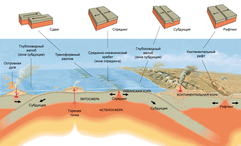
About the plates you already probably heard - these are huge stable fragments of lithosphere, which drift on a fluid asthenosphere, like broken ice along the river. However, there are two main differences between lithosphere and ice:
- The cutters between the plates are small, and are rapidly tightened due to the molten substance erupting from them, and the plates themselves do not destroy from collisions.
- Unlike water, the mantle does not have a constant course, which could set the constant direction of movement in the continent.
Thus, the driving force of the lithosphere drift is the convection of the asthenosphere, the main part of the mantle - more hot flows from the earth's kernel rise to the surface when the cold is lowered back down. Considering the fact that the continents differ in size, and the relief of their lower parties mirror reflects the irregularities of the top, they are also uneven and inconceive.

Main plates
For billions of years of the movement of lithospheric plates, they have repeatedly merged into supercontinents, after which they were again divided. In the near future, after 200-300 million years, the education of the supercontinent is also expected under the name of the Ultima Pangeus. We recommend watching the video at the end of the article - it clearly shows how lithospheric plates migrated over the past few hundred million years. In addition, the strength and activity of the continent movement determines the inner heating of the Earth - the higher it is higher, the stronger the planet is expanding, and the faster and freer moves lithospheric plates. However, since the beginning of the history of the Earth, its temperature and radius are gradually decreasing.
- An interesting fact - the drift of plates and geological activity does not have to eat from the internal self-heating of the planet. For example, the satellite of Jupiter, has a multitude of active volcanoes. But the energy of the satellite does not give energy for this, but the gravitational friction with, due to which the subsoil of IO is heated.
The boundaries of lithospheric plates are very conventional - some parts of the lithosphere are drowning under others, and some, like the Pacific cooker, are generally hidden under water. Geologists today are 8 main plates that cover 90 percent of the entire land area:
- Australian
- Antarctic
- African
- Eurasian
- Indostanskaya
- Pacific
- North American
- South American

Such a division appeared recently - so, the Eurasian stove another 350 million years ago consisted of separate parts, during the merger of which the Urals were formed, one of the most ancient on Earth. Scientists to this day continue to study the faults and the bottom of the oceans, opening new plates and specifying the borders of the old.
Geological activity
Lithospheric plates move very slowly - they are filled with each other at a speed of 1-6 cm / year, and removed as much as possible by 10-18 cm / year. But it is precisely the interaction between the continents create the geological activity of the Earth, tangible on the surface - the eruption of volcanoes, earthquakes and the formation of mountains always occur in the contact zones of lithospheric plates.
However, there are exceptions - the so-called hot spots that can exist in the depth of lithospheric plates. In them, the molten flows of the substance of the asthenosphere break through to the top, fluctuating the lithosphere, which leads to increased volcanic activity and regular earthquakes. Most often, this happens not far from those places where one lithospheric plate can be on the other - the lower, the renable part of the plate is immersed in the earth's mantle, thereby increasing the pressure of the magma on the top plate. However, now scientists tend to the version that the "drowned" parts of the lithosphere are melted, increasing the pressure in the depths of the mantle and thereby creating ascending flows. So you can explain the anomalous remoteness of some hot spots from tectonic faults.

- An interesting fact - in hot spots, panel volcanoes are often formed, characteristic of their common shape. They are erupted many times, scattered due to fluid lava. It is also a typical format of alien volcanoes. The most famous of them on Mars, the highest point of the planet - the height of it reaches 27 kilometers!
Oceanic and Continental Earth Bark
The interaction of the plates also leads to the formation of two different types of earthly crust - oceanic and continental. Since in the oceans, as a rule, there are joints of various lithospheric plates, their bark is constantly changing - it is cleaned or absorbed by other plates. At the site of faults, direct contact with mantia arises, from where the hot magma is rising. Cooled under the influence of water, it creates a thin layer of basalt - the main volcanic rock. Thus, the ocean bark is completely updated once every 100 million years - the oldest sites that are located in the Pacific, reach the maximum age in 156-160 million years.
Important! The ocean bark is not the whole earth bark, which is under water, but only its young sections at the junction of continents. Part of the continental cortex is under water, in the zone of stable lithospheric plates.

The age of the oceanic cortex (red corresponds to the young crust, blue - old).
The earth's crust, or geosphere is the outer solid shell of the Earth. Under the crust is a mantle, differing from it in composition and physical properties. The structure of the mantle is more dense, since it contains mainly refractory components. Democates a mantle with the border of the Mochorovichich border, or moho, on which the speed of seismic waves rises sharply. Most of the cortex outside is covered with hydrosphere, smaller borders with atmospheric air. In accordance with this, the earth's crop of oceanic and mainland types that have a different structure are distinguished. The total mass of the earth's crust, according to scientists, is only 0.5% of the total mass of the planet.
Building and composition
As part of the oceanic bark prevails basalt layer. According to the theory of tactics, the bark of this type is constantly formed in the mid-oceanic ridges, then departs from them and is absorbed into the mantle in the subducts areas. Therefore, the ocean bark is considered relatively young. In different geographical zones, the thickness of the oceanic crust varies from 5 to 7 km. It consists of basalt and sedimentary layers. Its thickness practically does not change over time because it depends on the amount of melt, distinguished from the mantle in the regions of the mid-ocean ridges. Also partially the thickness of the oceanic earth crust is determined by the thickness of the sedimentary layer at the bottom of the oceans and the seas. The thickness of the earth's crust increases with the removal from the sections of the mid-ocean ridges. For the mainland (continental) bark is characterized by a three-layer structure. The upper layer is the cover of sedimentary rocks, interrupted places. This cover is well developed, but rarely reaches high power. The average granite layer of continental cortex is most of the entire bark. It consists of gneisses and granite, has a low density and an ancient history of education. A large share of these breeds was formed about 3 billion years ago. The lower basalt layer consists of metamorphic breeds - granulites and similar substances. The average power of the continental bark is about 35 km, the maximum under the mountain ranges is 70-75 km. The composition of the cortex of this species includes many chemical elements and their compounds. Approximately half of the mass falls on oxygen, quarter - on silicon, the rest of the share is on Al, Fe, Ca, Na, K, Mg, H, Ti, C, C Cl, P, S, N, Mn, F, BA.
In the transition zone from the mainland to the oceans, the bark for transient (intermediate) type (sub-oschanical or subcontinental) was formed. The transition bark is characterized by a complex combination of features of the earth's crust of the two types described. The bark of the intermediate type corresponds to such areas as shelf, island arcs, oceanic ridges.
In the overwhelming majority of regions, the earth bark is in a state of relative isostatish equilibrium. Violation of isostatic compensation is observed on volcanic islands, oceanic depressions, island arcs. Here, the earth bark is constantly susceptible to tectonic movements. Large faults of the earth's crust can be considered as the result of the shift of tectonic plates in the areas of their joints. The structure of the crust distinguishes relatively calm areas (platforms) and movable (folded belts).
Similar materials:
Objectives lesson:
Continue the formation of the idea of \u200b\u200bthe diversity of the relief of the Earth.
To identify the patterns of placement of large form of relief and seismic belts of the Earth.
Forming the ability to read the frame of the structure of the earth's crust, compare and compare it with a physical card.
Equipment:
tutorial, Atlas, Physical Map of the world, Map of the structure of the earth's crust.
Main content:
ground bark on the map. Platform and its structure. Map of the structure of the earth's crust. Folded areas. Folded-bull and revived mountains. Placement on the land of mountains and plains.
Workshop.Designation on the contour map of the largest platforms and mountain systems.
Check homework:
1.
Name the main provisions of the theory of lithospheric plates.
2.
Show the largest lithospheric plates on the map.
3.
Describe the stages of the development of the earth's crust.
Studying a new material:
At the beginning of the lesson, the teacher asks to remember how the earth's crust differs. Distinguish mainland (continental) and oceanic types of terrestrial crust. In their structure, they are inhomogeneous. The continental bark consists of a sedimentary layer formed by multi-seed sedimentary rocks, a granite layer consisting of various magmatic and metamorphic rocks, and a basalt, consisting of high-albeal rocks.
The oceanic bark differs from the continental terrestrial crust with the absence or low power of the granite layer.
The mainland crust, especially in the mountains, is much thicker than oceanic. To systematize Knowledge, the teacher demonstrates the drawing on the school board.
According to the nature and strength of the movements, the earth's bour is divided into relatively sustainable and moving areas.
What processes affect the surface of the Earth? Answer: Domestic and external processes. The teacher explains how mainland platforms were formed.
Under the influence of internal (endogenous) processes on the surface of the earth's crust, a deflection arose, the bottom of which was descended for a long time, forming sea depressions. They filled over millions of years with powerful sedimentary rocks. Over time, the lowering was replaced by a lift, as a result of which folded mountain systems were gradually several of the deflection. This process was accompanied by volcanic eruptions and frequent earthquakes.
At the same time, external (exogenous) processes - weathelation, deposit of breeds by flowing waters, the work of the wind, the sea surf acted, under the influence of which through many millions of years the mountain regions turned into plains with severe bases. So on the site of the mountainous countries, there were relatively sustainable extensive sections of the earth's crust - mainland platforms.
On the map of the structure of the earth's bark, students find ancient platforms that serve as the basis of continents.
Knowledge of the structure of platforms. Students receive independently from the text § 9 (p. 32) and the analysis of Figure 24.
Next, the teacher talks about the moving areas of the earth's crust. After the explanation, he asks the question: why the moving areas of the cortex are painted in different color?
Comparing the map of the structure of the earth's crust and physical map of the world, students detect the patterns of accommodation on the surface of the Earth of various form of relief. Students should conclude that the structure of the earth's crust and the relief are naturally interrelated. Sustainable sections of the earth's crust - platforms - the relief corresponds to the plains. Moving areas of the earth's crust are folded belts - in the relief are represented by the mountains.
In the conclusion of the lesson, students are denoted by the largest platforms and mountain systems on the contour map.
Homework:
1) explore § 9; 2) Answer questions and perform tasks after paragraph.
Summary of other presentations"Wonders of the Krasnoyarsk Territory" - seven wonders of the Krasnoyarsk Territory. Siberia dance ensemble. Yenisei was in a deep crisis. Natural park "Ergaki". Miracles of the Krasnoyarsk Territory. Minusinskaya brass. Tunguska meteorite. Hockey team "Yenisei". Events. Cross-proven temple. Krasnoyarsk region. Vankor deposit.
"The game" Africa "" - Antelope. Animal world savanna. Ethiopian Highlands. Desert Namib. Cassava. Picture of the animal. Fagar. River Congo. Somalia Peninsula. Mainland. Kilimanjaro. Giant. African wild horse. Lake Victoria. Henry Morton Stanley. On which slope of the dragon mountains there are more precipitation. Date palm. Large animal. Symbol of Africa. Lake Chad. African connoisseurs. The game "Africa". Path to India. River Zambezi.
"Map of the mainland and oceans" - a snapshot of the Earth from Cosmos. Physical card. Climate card. Geography of continigs and oceans. Continents. Map of natural zones. How people opened the planet. Soil card. Parts of the world. Recall. Map of the structure of the earth's crust. General information. Map of climatic belts. The mainstream and islands.
"The" Atlantic Ocean "geography" - Icebergs can even meet in forty latitudes. These two flows of the Atlantic Ocean are warm. Ocean interaction, atmosphere and sushi. The history of the study of the ocean. Geographical position of the ocean. The purpose of the lesson. In which of these seas of the Atlantic Ocean, oil is extracted. Silent and Indian Oceans. Which latitudes are the most wide part of the Atlantic. Extensive shelves of the Atlantic Ocean.
"Ground Bark and Lithospheric Plates" - Lithosphere Plates. The structure of the earth's crust. Map of the structure of the earth's crust. Lithospheric plates and their movement. The ratio of sushi and ocean. Pangay decay. Check questions. The internal structure of the Earth. Platforms and seismic belts. Hypothesis of the origin of the continents and the collapses of the oceans.
"Ice Desert" - the inhabitants of the Polar region. "Ordinary Arctic." Whether arctid existed. Today, the icy desert is calm. Fascinating paintings are born on the dark heaven in the polar night. Wedding trip to Antarctica. Polar regions of the earth. It is believed that Arctic slowly sank to the bottom of the ocean. Tourists on special inflatable boats make a trip. White spots on a modern map. Much has changed since then.