Earth's crust. Structure of land
Read also
1. The deep structure of the Earth
The geographical envelope interacts, on the one hand, with the depth substance of the planet, on the other, with the upper layers of the atmosphere. The deep structure of the Earth has a significant impact on the formation of a geographic shell. The term "structure of the Earth" is usually denoted by its internal, i.e. the deep device, ranging from the earth's crust and to the center of the planet.
Earth weight - 5, 98 x 10 27
The average density of the Earth is 5, 517 g / cm 3.
The composition of the Earth. According to modern scientific ideas, the land consists of the following chemical elements: iron - 34, 64%, oxygen - 29, 53%, silicon - 15, 20%, magnesium - 12, 70%, nickel - 2, 39%, sulfur - 1 , 93%, chrome - 0, 26%, manganese - 0, 22%, cobalt - 0, 13%, phosphorus - 0, 10%, potassium - 0, 07%, etc.
The most reliable data on the inner structure of the Earth is observed over seismic waves, i.e. the oscillatory movements of the earth's substance caused by earthquakes.
A sharp change in the speed of seismic waves (fixed in seismographs) at a depth of 70 km and 2,900 km reflects the hopping increase in the density of the substance within these limits. This gives the basis of the following three shells (geospheres) in the inner body of the Earth: to the depth 70 km - the Earth Cora, from 70 km to 2,900 km - mantle, and from it to the center of the Earth - the core. The kernel is distinguished by the external core and the inner core.
The land formed about 5 billion years ago from some cold gas-dust nebula. After the mass of the planet has reached a modern value (5.98 x 10 27 g), its self-heating began. The main sources of heat were: first, gravitational compression, secondly, radioactive decay. As a result of the development of these processes, the temperature inside the Earth began to increase, which led to the melting of metals. Since in the center of the Earth, the substance was strongly compressed, and from the surface was cooled by radiation, then melting occurred mainly on small depths. Thus, a molten layer was formed, from which silicate materials, as the easiest, rose up, giving the beginning of the earth's crust. Metals remained at the melting level. Since their density is higher than that of non-differentiated deep substances, they gradually lowered. This led to the formation of a metal kernel.
The kernel is 85-90% consists of iron. At a depth of 2,900 km (the border of the mantle and nucleus) the substance is in the superhard state due to a huge pressure (1,370,000 atm.). Scientists assume that the external kernel is melted, and the inner core is in a solid state. Differentiation of the earth's substance and the selection of the nucleus is the most powerful process on Earth and the main, the first internal driving mechanism for the development of our planet.
The role of the nucleus in the formation of the magnetosphere of the Earth. The core has a powerful impact on the formation of the Earth's magnetosphere, protecting life from destructive ultraviolet radiation. In the electrically conductive external liquid core, the rapidly rotating planet occur complex and intensive motions of the substance, leading to the excitation of the magnetic field. The magnetic field extends to the near-earth space into several terrestrial radii. Interacting with the sunshine, the geomagnetic field creates the Earth's magnetosphere. The upper boundary of the magnetosphere is at an altitude of about 90 thousand km. The formation of the magnetosphere and the insulation of the earthly nature from the plasma of the solar crown was the first and one of the most important conditions for the origin of life, the development of the biosphere and the formation of a geographic shell.
The mantle consists mainly of MG, O, FEO and SiO2, which form a magma. Magma includes water, chlorine, fluorine and other volatile substances. In the mantle continuously proceeds the differentiation of the substance. Substances lightened to the removal of metals rise in the direction of the earth's crust, and heavier are lowered. Similar movements of the substance in the mantle are determined by the term "convection currents".
The concept of asthenosphere. The upper part of the mantle (in the range of 100-10 km) is called an asthenosphere. In the asthenosphere, the combination of temperature and pressure is such that the substance is in the molten, movable state. In the asthenosphere, not only constant convection currents occur, but also horizontal asthenospheric flows.
The speed of horizontal asthenospheric currents reaches only a few tens of centimeters per year. However, for the geological time, these flows led to a split lithosphere on separate boulders and their horizontal movement, known as the drift of the mainland. In the asthenosphere there are foci of volcanoes and earthquake centers. Scientists believe that geosynclinals are formed on descending currents, and over-upward average oceanic ridges and rhypsal zones.
2. The concept of earthly crust. Hypothesis explaining the origin and development of the earth's crust
The earth's crust is a complex of surface layers of the solid body of the Earth. In scientific geographical literature, there is no single idea of \u200b\u200bthe origin and pathways of the development of the earth's crust.
There are several hypotheses (theories) explaining the mechanism for the formation and development of the earth's crust. The most reasonable hypotheses are the following:
- 1. Fixism theory (from lat. Fixus is fixed, unchanged) argues that the continents have always remained in those places that they currently occupy. This theory denies any movement of the mainland and large parts of the lithosphere (Charles Darwin, A.Wolles, etc.).
- 2. The theory of mobilism (from lat. Mobilis - mobile) proves that the blocks of the lithosphere are in constant motion. This concept has been particularly established in recent years due to obtaining new scientific data in the study of the bottom of the World Ocean.
- 3. The concept of mainland growth due to the bottom of the ocean believes that the initial continents were formed in the form of relatively small arrays, which now constitute ancient mainland platforms. Subsequently, these arrays have grown due to the formation of mountains on the oceanic day, adjacent to the edges of the initial sushi nuclei. The study of the bottom of the oceans, especially in the mid-oceanic ridge zone, gave reason to doubt the correctness of this concept.
- 4. The theory of geosynclinal claims that the increase in sushi size occurs by the formation of mountains in geosynclinal. The geosynclinal process, as one of the main in the development of the mortar crust, is based on many modern scientific explanations.
- 5. Rotational theory builds its explanation in the situation that since the figure of the Earth does not coincide with the surface of the mathematical spheroid and rebuilding due to uneven rotation, the zonal strips and meridional sectors on the rotating planet are inevitably tectonically unequal. They with varying degrees of activity react to tectonic stresses caused by internally processes.
Ocean and mainland earth bark. There are two main types of terrestrial crust: ocean and mainland. Its transitional type is also highlighted.
Ocean earth bark. The power of the ocean crust in the modern geological era ranges from 5 to 10 km. It consists of the following three layers:
- 1) the upper thin layer of marine precipitation (power not more than 1 km);
- 2) the average basalt layer (power from 1.0 to 2.5 km);
- 3) lower layer of gabbro (power of about 5 km).
Mainland (continental) earth bark. The mainland crust has a more complex structure and greater power than the ocean. Its capacity on average is 35-45 km, and in mining countries increases to 70 km. It consists of the following three layers:
- 1) lower layer (basalt), folded basalts (power of about 20 km);
- 2) the middle layer (granite) formed mainly by granites and gneis; forms the mainstream of the mainland cortex, the oceans do not apply;
- 3) upper layer (sediment) with a capacity of about 3 km.
In some areas, precipitation capacity reaches 10 km: for example, in the Caspian lowland. In certain areas of the Earth, the sedimentary layer is absent at all and the layer of granite comes to the surface. Such areas are called shields (for example, the Ukrainian shield, the Baltic Shield).
On the mainland, as a result of weathering, the geological formation is formed, the name of the weathered bark.
The granite layer from the basalt is separated by the surface of the conrad. At this border, the speed of seismic waves increases from 6.4 to 7.6 km / s.
The border between the earth's crust and mantle (both in the continent and on the oceans) passes through the surface of Mochorovichich (Mokho line). The speed of seismic waves on it is jumping up to 8 km / h.
In addition to the two main types of earthly crust (ocean and mainland), there are also sections of a mixed (transitional) type.
On the mainland shallows or shelves, the bark has a capacity of about 25 km and is generally similar to the mainland crust. However, it can fall a layer of basalt. In East Asia in the area of \u200b\u200bisland arcs (Kuril Islands, Aleuta Islands, Japanese Islands, etc.), the earth's crust type is common. Finally, the earthly bark of the median oceanic ridges has been very difficult and so far. There is no border of Mocho, and the substance of the mantle on faults rises to the bark and even on its surface.
The concept of "earth bark" should be distinguished from the concept of a "lithosphere". The concept of "lithosphere" is wider than the "earth bark". In a lithosphere, modern science includes not only the earth's bark, but also the highest mantle to the asthenosphere, that is, to the depth of about 100 km.
The concept of isostasy. The study of the distribution of gravity has shown that all parts of the earth's crust are continents, mountainous countries, plains - balanced on the upper mantle. This balanced position is called IsoC (from Lat. Isoc - even, stasis - position). Isostatic equilibrium is achieved due to the fact that the power of the earth's crust is inversely proportional to its density. Heavy ocean bark thinner easier mainland.
Isostasi is not even equilibrium, but the desire for equilibrium, continuously broken and newly restored. So, for example, the Baltic Shield after stating the continental ice of the Pleistocene glaciation rises by about 1 cm per year. Finland's area all the time increases at the expense of the seabed. The territory of the Netherlands, on the contrary, decreases. The zero equilibrium line is currently somewhat south of 600 s.sh. Modern St. Petersburg is approximately 1.5 m higher than St. Petersburg Times Peter First. According to the data of modern scientific research, even the severity of large cities is sufficient for the isostatic oscillation of the territory under them. Therefore, the earth's crust in the zones of large cities is very mobile. In general, the relief of the earth's crust is a mirror reflection of the surface of the Mocho (soles of the earth's crust): the sublime areas correspond to the deepening in the mantle, reduced - a higher level of its upper boundary. So, under Pamir, the depth of the Mocho surface is 65 km, and in the Caspian lowland - about 30 km.
Thermal properties of the earth's crust. Daily fluctuations in the soil temperature range to depth 1.0 - 1.5 m, and annual fluctuations in moderate latitudes in countries with a continental climate - to a depth of 20-30 m. At that depth, where the effect of annual fluctuations in temperature due to the heating of the earth's surface is a layer of constant soil temperature. It is called an isothermal layer. Below isothermal layer deep into the earth is rising. But this temperature increase is caused by the internal warmth of the earth's immortal. In the formation of climates, internal heat is practically not involved. However, it serves as the only energy basis of all tectonic processes.
The number of degrees that increase the temperature for every 100 m depth is called a geothermal gradient.
The distance in meters, when lowering for which the temperature increases by 10c, is called a geothermal step. The magnitude of the geothermal stage depends on the relief, thermal conductivity of rocks, proximity of volcanic foci, circulation of groundwater, etc. On average, the geothermal stage is equal to 33 m. In volcanic regions, the geothermal stage can be equal to only 5 m, and in geologically calm areas (on platforms) It can reach 100 m.
3. Structural and tectonic principle of mainstreaming. Concept of continental and parts of light
Two qualitatively different types of earthly crust - mainland and oceanic - correspond to two main levels of the planetary relief - the surface of the continents and the beds of the oceans. The separation of continents in modern geography is carried out on the basis of a structural and tectonic principle.
Structural and tectonic principle of mainstreaming.
A fundamentally qualitative difference in the mainland and oceanic cortex, as well as some significant differences in the structure of the upper mantle under the mainland and oceans, obligate to allocate continents do not seem to surround them with the oceans, but according to the structural and tectonic principle.
The structural and tectonic principle argues that, firstly, the mainland includes mainland shallow (shelf) and the mainland slope; secondly, the basis of each mainland is a kernel or an ancient platform; Thirdly, each mainstall boulder is statically balanced in the upper mantle.
From the point of view of the structural and tectonic principle, the mainland is the isostatically balanced array of the continental terrestrial crust having a structural nucleus in the form of an ancient platform to which younger folded structures are adjacent.
There are six continents on Earth: Eurasia, Africa, North America, South America, Antarctica and Australia. As part of each mainland, there is one platform and only Eurasia are six: Eastern European, Siberian, Chinese, Tarima (Western China, Takla-Makan desert), Arabian and Industan. The Arabian and Industan platforms are part of the ancient Gondwana, who joined Eurasia. Thus, Eurasia is a heterogeneous abnormal mainland.
The boundaries between the continents are quite obvious. The border between North America and South America takes place through the Panama Canal. The border between Eurasia and Africa is carried out on the Suez Channel. Bering Strait separates Eurasia from North America.
Two rows of continents. In modern geography, the following two rows of continents are distinguished:
- 1. Equatorial row of continents (Africa, Australia and South America).
- 2. Northern Mainland Series (Eurasia and North America).
Outside these series remains Antarctica - the most southern and cold continent.
The modern location of the mainland reflects the long history of the mainland lithosphere.
The southern mainbirds (Africa, South America, Australia and Antarctica) are parts ("fragments") of the united in Paleozoic MegaContinent Gondwana. Northern continents at the time were combined into another megactinant - Laurelasia. Between Lavolasia and Gondwana in Paleozoic and Mesozoy, there was a system of extensive marine pools, called the Ocean Tethys. This ocean stretched from North Africa (through South Europe, Caucasus, front Asia, Himalayas in Indochina) to modern Indonesia. In Neogene (about 20 million years ago), an alpine grass belt arose at the site of this geosynclinal.
Accordingly, its large sizes of the Gondwan superctinet, according to the law of isostaste, had a powerful (up to 50 km) of the Earth Craer, which was deeply immersed in the mantle. Under this supercontinent in the asthenosphere, convection currents were particularly intense; The softened matter of the mantle was moved very actively. This led to the formation of bloating in the middle of the continent, and then to split it into separate blocks, which under the action of the same convection currents began to move horizontally. It is known that the movement of the circuit on the surface of the sphere is always accompanied by its turn (Euler, etc.). Therefore, parts of the Gondwana not only moved, but also unfolded in geographical space.
The first split of Gondwana occurred on the border of Triass and Yura (about 190-195 million years ago); Separated African America. Then at the border of Yura and Chalk (about 135-140 million years ago) South America separated from Africa. On the border of the Mesozoic and Cenozoic (about 65-70 million years ago), the Industan Balb faced Asia, and Antarctica moved away from Australia. In the real geological era of a lithosphere, according to scientists, is divided into six plates blocks that continue to move.
The decay of the Gondwana successfully explains the form, geological similarity, as well as the history of the vegetation cover and the animal world of southern continents. The history of the lascation split is so carefully as Gondwans, not studied.
Laws of the location of the mainland. The current location of the mainland is characterized by the following patterns:
- 1. Most of the sushi is located in the northern hemisphere. The northern hemisphere is mainland, although here it accounts for only 39%, and about 61% on the ocean.
- 2. Northern continents are located quite compact. The southern continents are located very scattered and disassembled.
- 3. The relief of the planet anti-Semitrich. The continents are located so that each of them on the opposite side of the earth certainly corresponds to the ocean. It is best possible to see on comparison of the Arctic Ocean and Antarctic Sushi. If the globe is to install so that in one of the poles there is any of the mainland, then the Ocean will definitely be on the other pole. There is only one minor exception: the end of South America of Antipodally Southeast Asia. Antipodality because it almost does not have exceptions, it cannot be a random phenomenon. The basis of this phenomenon is the equilibiousness of all sections of the surface of the rotating land.
The concept of parts of the world. In addition to the geologically determined division of sushi to the continents, there is also a division of the earth's surface into separate parts of the world in the process of cultural and historical development of mankind. In total there are six parts of the world: Europe, Asia, Africa, America, Australia with Oceania, Antarctica. On one mainland, Eurasia is located two parts of the world (Europe and Asia), and two mainland of the Western Hemisphere (North America and South America) form one part of the world - America.
The border between Europe and Asia is very conditional and is carried out along the water-seed line of the Ural Range, the Ural River, the Northern part of the Caspian Sea and Kuma Manic Wpadin. In the Urals and the Caucasus, lines of deep faults separating Europe from Asia pass.
The area of \u200b\u200bthe mainland and oceans. Sushi area is calculated within the modern coastline. The surface area of \u200b\u200bthe globe is approximately 510, 2 million km 2. About 361, 06 million km2 occupies the world ocean, which is about 70.8% of the total surface of the Earth. Sushu accounts for approximately 149, 02 million km 2, i.e. About 29, 2% of the surface of our planet.
The area of \u200b\u200bmodern mainland is characterized by the following values:
Eurasia - 53, 45 km2, including Asia - 43, 45 million km2, Europe - 10, 0 million km2;
Africa - 30, 30 million km2;
North America - 24, 25 million km2;
South America - 18, 28 million km2;
Antarctica - 13, 97 million km2;
Australia - 7, 70 million km2;
Australia with Oceania - 8, 89 km2.
Modern oceans have an area:
Pacific Ocean - 179, 68 million km2;
Atlantic Ocean - 93, 36 million km2;
Indian Ocean - 74, 92 million km2;
The Arctic Ocean - 13, 10 million km2.
Between the northern and southern continents (in accordance with their different origins and development) there is a significant difference in the area and the nature of the surface. The main geographical differences between the northern and southern continents are reduced to the following:
- 1. It is incomparable with other continents of Eurasia, which focuses more than 30% of the sushi of our planet.
- 2. Northern continents are significant in the Schelf Square. The shelf in the Arctic Ocean and the Atlantic Oceans, as well as in the yellow, Chinese and Bering Seas of the Pacific Ocean, is particularly significant. Southern continents, with the exception of the underwater continuation of Australia in the Arafur Sea, almost deprived of the shelf.
- 3. Most of the southern mainland falls on the ancient platforms. In North America and Eurasia, the ancient platforms occupy a smaller part of the total area, and most of them accounted for in the territory formed by Paleozoic and Mesozoic region. In Africa, about 96% of its territory falls on platform areas and only 4% - on the Mountains of Paleozoic and Mesozoic age. In Asia, only 27% of the territory occupies ancient platforms and 77% - mountains of different ages.
- 4. Coastline of southern mainland, formed by most of the tectonic faults, relatively straightforward; Peninsula and mainland islands are small. For the northern continents, an exceptionally winding coastline is characterized, the abundance of islands, peninsulas, often far-reaching in the ocean. Of the total area on the islands and the Peninsula, it is in Europe about 39%, North America - 25%, Asia - 24%, Africa - 2.1%, South America - 1.1% and Australia (without Oceania) - 1.1% .
- 4. Vertical Sushi Dismemberment
Each of the main planetary levels - the surfaces of the mainland and ocean lodge - disintegrates on a number of secondary levels. The formation of both basic and secondary levels occurred in the process of long-term development of the earth's crust and continues in real geological time. Let us dwell on the modern dismemberment of the mainland crust on high-altitude steps. The account of the steps is conducted from the sea level.
- 1. Depressed - land plots underlying the sea level. The largest depression is the southern part of the Caspian lowland with a minimum mark of -28 m. Inside Central Asia, there is an extremely dry Turfankina with a depth of about -154 m. The deepest depression on Earth is the brand of the Dead Sea; The shores of the Dead Sea lie 392 m below sea level. Depressed by water, the levels of which lie above the ocean level, are called cryptodepresses. Typical examples of cryptodepresses are Lake Baikal and Lake Ladoga. The Caspian Sea and the Dead Sea are not cryptodepresses, because The water level in them does not reach the level of the ocean. The area occupied by depression (without cryptodepresses) is relatively small and is about 800 thousand km2.
- 2. lowlands (low-albele plains) - land plots lying at a height from 0 to 200 m above sea level. The lowlands are numerous on each mainland (with the exception of Africa) and occupy a large area than any other land sushi. The total area of \u200b\u200ball lowland plains of the globe is about 48.2 million km2.
- 3. Hill and plateau lie at a height of 200 to 500 m and differ among themselves the prevailing form of relief: on the elevation the relief crossed, on the plateau is relatively flat. Highlands over lowlands rise gradually, and a plateau is a noticeable ledge. Hills and plateau differ in each other and geological structure. The area occupied by hills and the plateau is about 33 million km2.
Above 500 m are mountains. They may have different origins and age. At the height of the mountain is divided into low, medium and high.
- 4. Low mountains rise no higher than 1,000 m. Usually low mountains are either ancient destroyed mountains, or the foothills of modern mountain systems. Lowlya occupy about 27 million km 2.
- 5. Mid-medium mountains have a height from 1,000 to 2,000 m. Examples of the average mountains are: Urals, Carpathians, Transbaikalia, some ridges of Eastern Siberia and many other mountain countries. The area occupied by the Middle Mountains is about 24 million km 2.
- 6. High (Alpine) Mountains rise above 2,000 m. The term "Alpine Mountains" is often used in relation to the mountains of the Cenozoic age lying at an altitude of more than 3,000 m. The high mountains account for about 16 million km2.
Below the level of the ocean continues the mainland lowland, flooded with water, the shelf, or the mainland shallow. Until recently, on the same conventional account as the sushi steps, the shelf was called underwater plains with depths of up to 200 m. Now the shelf border is carried out not according to a formally elected isobate, but along the actual, geologically determined ending with the mainland and transition to the mainland slope . Therefore, the shelf continues in the ocean to different depths in each sea, often exceeding 200 m and reaching 700 and even 1,500 m.
The outer edge of a relatively flat shelf occurs a sharp fracture of the surface to the mainland slope and the continental foot. The shelf, the slope and the foot together form the underwater outskirts of the continents. It continues on average to a depth of 2,450 m.
The continents, including their underwater outskirts, occupy about 40% of the ground surface, while the land area is about 29.2% in common.
Each mainland is statically balanced in the asthenosphere. Between the mainland area, their relief height and the depth of immersion in the mantle there is direct dependence. The larger the area of \u200b\u200bthe continent, the greater its average height and power of the lithosphere. The average height of sushi is 870 m. The average height of Asia is 950 m, Europe - 300 m, Australia - 350 m.
The concept of plasterometric (baaptific) curve. The generic profile of the earth's surface is presented by a plaster curve. Part of it relating to the ocean is called a batigraphic curve. The curve is constructed as follows. The dimensions of the areas lying at various heights and depths are removed from plaster and batigraphic maps and are postponed in the system of coordinate axes: along the ordinate line is deposited from 0 upward height, and down - depth; on the line of the abscissa - square in millions of square kilometers.
5. Relief and structure of the Day of the World Ocean. Islands
The average depth of the oceans is 3,794 m.
The bottom of the World Ocean consists of the following four planetary morphoskulpural forms:
- 1) underwater outbreaks,
- 2) transition zones,
- 3) Ocean's bed,
- 4) Middle-ocean ridges.
The underwater outskirts of the mainland consists of the shelf, the mainland slope, the mainland foot. It is lowered to a depth of 2,450 m. The earth bark here has a mainland type. The total area of \u200b\u200bthe underwater edge of the mainland is about 81.5 million km2.
The mainstream is immersed in the ocean relatively cool, the slopes on average are about 40, but sometimes they reach 400.
The continental foot is a deflection on the border of the mainland and oceanic earthly crust. Morphologically, this accumulative plain, formed by precipitation, demolished from the mainland slope.
The mid-oceanic ridges are a single and continuous system covering all oceans. They constitute huge mountain structures reaching 1-2 thousand km wide and rising over the oceanic lies by 3-4 thousand km. Sometimes the median and ocean ridges rise above the ocean and form numerous islands (Iceland Island, Azores, Seychelles, etc.). According to the Grand Distance, they significantly exceed the mountainous countries of the continents and are commensurate with continents. For example, the Mid-Atlantic Range several times the largest land mountain system Cordiller and Andes. For all median and oceanic ridges, elevated tectonic activity is characteristic.
The system of mid-ocean ridges includes the following structures:
- - The Mid-Atlantic Ridge (stretches from Iceland along the entire Atlantic Ocean to the Tristan da Cunya Island);
- - Mid-Indian Range (its vertices are expressed by the Seychelles);
- - East Pacific Raising (extends south of the California Peninsula).
According to the relief and the peculiarities of tectonic activity, the mid-oceanic ridges are: 1) rhyps and 2) non-rotating.
Rift ridges (for example, the mid-Atlantic) are characterized by the presence of a "rift" valley - deep and narrow gorges with steep slopes (the gorge comes along the ridge ridge along its axis). The width of the rift valley is 20-30 km, and the fracture depth can be located below the ocean bed up to 7,400 m (Vpadina Romanesh). Relief rhypsal ridges complex crossed. For all ridges of this type, rift valleys are characterized by rift valleys, narrow mountain ranges, gigantic transverse faults, intermountain deposits, volcanic cones, underwater volcanoes, islands. All rhypsal ridges are distinguished by large seismic activity.
The revolving ridges (for example, the East Pacific Raising) are characterized by the absence of a "rift" valley and have less complex relief. Seismic activity for non-timing ridges is not characteristic. However, they are characterized by a common feature of all the mid-ocean ridges - the presence of ambitious transverse faults.
The most important geophysical features of the mid-ocean ridges are reduced to the following:
- -the expectation of the heat flow from the bowels of the earth;
- -Special structure of the earth's crust;
- -Anomali magnetic field;
- -evulcanism;
- -Seismic activity.
The distribution of precipitation, the high-layer of the earth's crust, in the mid-oceanic ridges is subject to the following pattern: at the ridge itself, the precipitation is low or absent at all; With removal from the ridge, the capacity of precipitation increases (up to several kilometers) and their age. If in the seasus itself, the age of Love is about 13 thousand years, then 60 km - already 8 million years. Mountain breeds with age more than 160 million years have not been detected at the bottom of the world's ocean. These facts indicate the constant updating of the mid-oceanic ridges.
Mechanisms for the formation of mid-ocean ridges. The formation of the mid-ocean ridges is associated with the upper magma. Upper magma is a huge convection system. According to scientists, the formation of the mid-ocean ridges causes the rise of the inner substance of the Earth. According to the rift valleys, the lava flows out and forms a basalt layer. By connecting to the old crust, the new portions of the lava cause horizontal displacement of the lithosphere blocks and the expansion of the oceanic bottom. The speed of horizontal movements in different places of the Earth ranges from 1 to 12 cm per year: in the Atlantic Ocean - about 4 cm / year; In the Indian Ocean - about 6 cm / year, in the Pacific Ocean - up to 12 cm / year. These insignificant values \u200b\u200bmultiplied by millions of years give huge distances: for 150 million years since the collapse of South America and Africa, these continents diverged 5 thousand km. North America separated from Europe 80 million years ago. And 40 million years ago, Hindostan ran into Asia and the formation of Himalayas began.
As a result of the growth of the oceanic bottom in the zone of the mid-ocean ridges, it is not at all increments of the earth's substance, but only its flow and transformation. The basalt bark, growing along the mid-ocean ridges and spreading horizontally from them, for millions of years there are thousands of kilometers and some edges of the continents fall again in the bowels of the earth, carrying out and oceanic precipitation. This process explains the various ages of rocks on the ridge crest and in other parts of the oceans. This process also causes the drift of the mainland.
Transition zones include deep-water gutters, island arcs and basins of the seasons. In transition zones, areas of the mainland and oceanic cortex are complex.
Deep-sea oceanic chute are in the following four areas of the Earth:
- - In the Pacific Ocean along the shores of East Asia and Oceania: Aleutian chute, smoke-kamchatsky chute, Japanese chute, Philippine chute, Marian chute (with a depth of 11 022 m at a maximum of a depth of 11,022 m), Tonga;
- - in the Indian Ocean - Javanese gutter;
- - in the Atlantic Ocean - Puerto Ricansky Gutter;
- - In the South Ocean - South Sandvichev.
The ocean beds, which accounts for about 73% of the total area of \u200b\u200bthe World Ocean, is engaged in deep-water (from 2,450 to 6,000 m) plains. In general, these deep-water plains correspond to oceanic platforms. There are mid-ocean ridges between the plains, as well as the hill and raising the other genesis. These raises are separated by the beds of the oceans on separate basins. For example, from the North-Atlantic Range to the West there is a north-American brand, and east - Western European and Canary Basin. At the bottom of the ocean there are numerous volcanic cones.
Islands. In the process of developing the earth's crust and its interaction with the World Ocean, large and small islands were formed. The total number of islands is continuously changing. Some of the islands occur, others disappear. Forged and blur, for example, delta islands, ice arrays, taken earlier behind the islands ("land"). Sea braids acquire an island character and, on the contrary, the islands are joined by land and turn into the peninsula. Therefore, the area of \u200b\u200bthe islands is calculated only approximately. It is about 9.9 million km2. About 79% of the entire island sushi falls on 28 major islands. The largest island is Greenland (2.2 million km2).
IN The number of the 28 largest islands of the globe includes the following:
- 1. Greenland;
- 2. New Guinea;
- 3. Kalimantan (Borneo);
- 4. Madagascar;
- 5. Buffhin Earth;
- 6. Sumatra;
- 7. United Kingdom;
- 8. Honshu;
- 9. Victoria (Canadian Arctic Archipelago);
- 10. Earth Elsmir (Canadian Arctic Archipelago);
- 11. Sulawesi (Khalebs);
- 12. Southern New Zealand Island;
- 13. Java;
- 14. North Island of New Zealand;
- 15. Newfownland;
- 16. Cuba;
- 17. Leson;
- 18. Iceland;
- 19. Mindanao;
- 20. New Earth;
- 21. Haiti;
- 22. Sakhalin;
- 23. Ireland;
- 24. Tasmania;
- 25. BANKS (Canadian Arctic Archipelago);
- 26. Sri Lanka;
- 27. Hokkaido;
- 28. Devon.
Both large and small islands are located or single, or groups. Groups of islands are called archipelago. Archipelagoes can be compact (for example, the land of Franz Joseph, Spitsbergen, the Large Sunda Islands) or extended (for example, Japanese, Filipino, Large and Small Antilles). Extracted archipelagos are sometimes called ridges (for example, Kuril Ridge, Aleuta ridge). The archipelagoes of small islands scattered through the expanses of the Pacific Ocean are united in the following three large groups: Melanesia, Micronesia (Caroline Islands, Mariana Islands, Marshall Islands), Polynesia.
By origin, all the islands can be grouped as follows:
I. Mainland Islands:
- 1) platform islands,
- 2) the islands of the mainland slope,
- 3) Oroghenic islands,
- 4) island arcs,
- 5) Coastal Islands: a) Schhers, b) Dalmatian, c) fjord, d) braids and arrows, e) delta.
II. Independent islands:
- 1) volcanic islands, including a) fracture outpouring of lava, b) central outpouring lava - shield and conical;
- 2) Coral Islands: a) coastal reefs, b) barrier reefs, c) atoll.
The mainland islands are genetically connected with the continents, but these are different in nature, which affects the nature and age of the islands, on their flora and fauna.
Platform islands lie on the mainland shale and geologically constitute the continuation of the mainland. From the main array of sushi, platform islands are separated by shallow straits. Examples of platform islands are: British Islands, Svalbard Archipelago, Land Franz Joseph, North Earth, Novosibirsk Islands, Canadian Arctic Archipelago.
The formation of straits and the transformation of a part of the mainland in the island refers to a recent geological time; Therefore, the nature of the island sushi differs little from the mainland.
The islands of the mainland slope are also parts of the continents, but their separation occurred earlier. These islands from adjacent continents are separated by non-severe deflection, but a deep tectonic fault. Moreover, the sheds are oceanic. Flora and fauna of the islands of the mainland slope is very different from the mainland and is in general island character. Examples of the islands of the mainland slope are: Madagascar, Greenland, etc.
Oroghenic islands are a continuation of the mountains of the continents. So, for example, Sakhalin is one of the folds of the Far Eastern Mountain Country, New Zealand - the continuation of the Urals, Tasmania - the Australian Alps, the Islands of the Mediterranean Sea - the branches of the Alpine folds. Archipelago New Zealand also has an orogonic origin.
Island Arc garlands are focused on East Asia, America and Antarctica. The largest area of \u200b\u200bIsland Doug is near the coast of East Asia: Aleuta ridge, Kuril Ridge, Japanese ridge, Ryuku, Philippine ridge, etc. The second area of \u200b\u200bIsland Arc is located off the coast of America: Large Antilles, Small Antilles. The Third District is an island arc located between South America and Antarctica: Archipelago Fire Earth, Falkland Islands, etc. In tectonic terms, all island arcs are confined to modern geosynclinal.
Mainland coastal islands have different origins and are different types of coastline.
Independent islands have never been part of the mainland and in most cases were formed regardless of them. The most extensive group of independent island is volcanic.
Volcanic islands are in all oceans. However, there are many of them many in the zones of the mid-ocean ridges. The dimensions and features of the volcanic islands are determined by the character of the eruption. The fractured outpouring of the lava create large islands, in size not inferior to the platform. The biggest island of volcanic origin on earth is Iceland (103 thousand km2).
The main mass of volcanic islands is formed by central type eruptions. Naturally, these islands cannot be very large. Their area depends on the nature of the lava. The main lava spreads over long distances and forms panel volcanoes (for example, Hawaiian Islands). The eruption of acid lava forms a sharp cone of a small area.
Coral islands are the products of the vital activity of coral polyps, diatoms of algae, foraminifera and other marine organisms. Coral polyps are rather demanding on habitat. They can live only in warm waters with a temperature not lower than 200С. Therefore, coral buildings are distributed only in tropical latitudes and go beyond their limits in one place - in the area of \u200b\u200bthe Bermuda islands, washed by Golfustrim.
Depending on the location, coral islands are divided into the following three groups with respect to modern land:
- 1) coastal reefs,
- 2) barrier reefs,
- 3) Atoll.
Coastal reefs begin directly from the bank of the mainland or island in the low tide strip and focus it in the form of a wide terrace. Near the mouths of the rivers and near the mangroves are interrupted because of the reduced salinity of water.
Barrier reefs are at some distance from sushi, separated from her strip of water - lagoon. The biggest reef is a big barrier reef. Its length is about 2,000 km; The width of the lagoon ranges from 35 to 150 km at a depth of 30-70 m. Coast and barrier reefs are almost all the islands of the equatorial and tropical waters of the Pacific Ocean.
Atolls are located among the oceans. This is the low islands in the form of an unclosed ring. The diameter of the atoll fluctuates from 200 m to 60 km. Inside the atoll is a lagoon depth to 100 m. This is the depth and strait between the lagoon and the ocean. The outer slope of the atoll is always steep (from 9 to 450). Slopes facing the lagoon, gentle; They have a variety of organisms.
The genetic connection of the three types of coral buildings is another unresolved scientific problem. According to the theory of Charles Darwin, barrier reefs and the atolls are formed from coastal reefs with a gradual immersion of the islands. At the same time, the growth of corals compensates for lowering its foundation. A lagoon appears on the site of the top of the island, and the coastal reef turns into a ring atoll.
Continents
Continents, or continents, are huge arrays-plates of a relatively powerful crust (its thickness is 35-75 km), surrounded by the World Ocean, which is thin. Geological continents are somewhat more than their geographical outlines, because have underwater continuations.
In the structure of the continents, three types of structures are distinguished: platforms (flat forms), orogens (born mountains) and submarine outskirts.
Platform
Platforms are characterized by a hollow-fired, low-albele or pla on relief. They have shields and a thick multi-layer case. Shields are composed of very durable rocks, the age of which is from 1.5 to 4.0 billion years. They arose at high temperatures and pressures at large depths.
The same ancient and robust breeds are also composed of the rest of the platforms, but here they are hidden under a thick cloak of sediment sediments. This cloak is called a platform cover. It can really be compared with a cover for furniture, which saves it from damage. Parts of platforms covered with such a sedimentary case are called plates. They are flat, as if the layers of sedimentary rocks were infused iron. About 1 billion years ago, layers of the case began to accumulate, and the process continues to the present. If the platform could be cut with a huge knife, we would see that it looks like a puff pie.
Shields have a rounded and convex shape. They arose where the platform was slowly rising very long time. Duravel rocks were subjected to the destructive effect of air, water, they had an influence of a change of high and low temperatures. As a result, they were cracking and crumbled into small pieces that were worn away to the surrounding seas. Shields are composed of very ancient, highly modified (metamorphic) rocks formed several billion years at high depths at high temperatures and pressures, in some places a high temperature forced the breed to melt, which led to the formation of granite arrays.
Pages: 1.
Basic structural elements of the earth's crust: The largest structural elements of the earth's crust are continents and oceans.
Within oceans and continents, less large structural elements are highlighted, firstly, these are stable structures - platforms that can be both in the oceans and on continents. They are characterized, as a rule, aligned, calm relief, which corresponds to the same position of the surface at a depth, only under the continental platforms, it is at depths of 30-50 km, and under the oceans 5-8 km, as the ocean bark is much thinner continental.
In the oceans, as structural elements, the mid-oxygen moving belts are highlighted, represented by the mid-ocean ridges with rhythic zones in their axial part, crossed transform faults and are currently zones spreading. Expansion of the ocean bottom and increasing the newly formed ocean bark.
On continents as structural elements of higher grade, stable areas are allocated - platforms and epiplatform orogenic belts, formed in non-co-quaternary time in the stable structural elements of the earth's crust after the period of platform development. Such belts include modern mountain structures Tian-Shan, Altai, Sayan, Western and East Transbaikalia, East Africa, etc. In addition, mobile geosynclinal belts, subjected to folding and orogenesis in the Alpine Epoch, i.e. Also in neogen-quaternary time, epigeosynclinal orogo belts are made, such as the Alps, Carpathians, Dinarids, Caucasus, Copetdag, Kamchatka, etc.
The structure of the earth's crust of continents and oceans:Earth Cora - Exterior Determining Earth Shell (Geosphere). Below the cortex is a mantle, which is characterized by the composition and physical properties - it is more dense, contains mainly refractory elements. It shares the bark and the mantle of the Mochorovichi border, on which there is a sharp increase in the rates of seismic waves.
The mass of the earth's crust is estimated at 2.8 · 1019 tons (21% of them are the ocean bark and 79% - continental). The bark is only 0.473% of the total mass of the Earth.
Oceanicaya Bark: The ocean bark consists mainly of basalts. According to the theory of tactonic plates, it is continuously formed in the mid-oceanic ridges, diverges from them and is absorbed into the mantle in the subduction areas (place where the ocean bark is immersed in the mantle). Therefore, the oceanic bark is relatively young. Ocean. The bark has a three-layer structure (sedimentary - 1 km, basalt - 1-3 km, magmatic breeds - 3-5 km), its total capacity is 6-7 km.
Continental bark:The continental bark has a three-layer structure. The upper layer is represented by intermittent cover of sedimentary rocks, which is developed widely, but rarely has a greater power. Most of the cortex is composed under the upper bark - a layer consisting mainly of granites and gneisses with low density and ancient history. Studies show that most of these breeds were formed for a very long time, about 3 billion years ago. Below is the lower bark, consisting of metamorphic breeds - granulites and the like. Average power of 35 km.
Chemical composition of the earth and earthly crust. Minerals and rocks: definition, principles and classification.
The chemical composition of the Earth:it consists mainly of iron (32.1%), oxygen (30.1%), silicon (15.1%), magnesium (13.9%), sulfur (2.9%), nickel (1.8% ), calcium (1.5%) and aluminum (1.4%); The remaining elements account for 1.2%. Due to segregation by weight, the inner space, presumably, consists of iron (88.8%), a small amount of nickel (5.8%), sulfur (4.5%)
The chemical composition of the earth's crust: The earth is a little more than 47% consists of oxygen. The most common breeding minerals of the earth's crust almost completely consist of oxides; The total chlorine, sulfur and fluorine content in rocks is usually less than 1%. The main oxides are silica (SiO2), alumina (Al2O3), iron oxide (FEO), calcium oxide (CaO), magnesium oxide (MgO), potassium oxide (K2O) and sodium oxide (Na2O). Silica serves mainly by the acid medium, forms silicates; The nature of all major volcanic rocks is associated with it.
Minerals: -natural chemical compounds as a result of certain physical and chemical processes. Most minerals are crystalline bodies. The crystalline form is due to the structure of the crystal lattice.
In the prevalence of minerals can be divided into rock-forming - the components of the basis of most rocks, accessor - frequently present in rocks, but rarely found more than 5% of rock, rare, cases of which are single or few, and ore, widely represented in ore deposits.
SV-Va Minerals:hardness, morphology of crystals, color, gloss, transparency, spares, density, solubility.
Rocks:natural set of minerals of more or less permanent mineralogical composition, forming an independent body in the earth's crust.
By origin, rock rocks are divided into three groups: igmatic (Effusion (frozen at depth) and intrusive (volcanic, empty)), sediment and metamorphic(rock rocks formed in the thickness of the earth's crust as a result of changes in sedimentary and magmatic rocks due to changes in physicochemical conditions). The magmatic and metamorphic rock rocks flow about 90% of the volume of the earth's crust, however, on the modern surface of the mainland areas of their distribution relatively small. The remaining 10% comes to the share of sedimentary rocks, occupying 75% of the area of \u200b\u200bthe earth's surface.
The earth's crust that has an average power of about 40 km and the constituent of just 1/160 from the radius of the Earth. The earth's crust, together with a part of the upper mantle to the asthenospheric layer, is called a lithosphere, and the lithosphere, together with the asthenosphere, forms a textureosphere, the upper sheath of the globe is largely responsible for the processes occurring in the earth's crust. The structure of the earth's crust, the power of which varies from almost 0 to 70-75 km and has a clear lower boundary - the Mochorovichi or "M" surface is fundamentally different on continents and in the oceans.
Information about the Core we receive from direct observation of rocks on the surface of the Earth, especially on the shields of ancient platforms, from the core of deep and ultra-double wells, both on land and in the oceans; xenolites in volcanic rocks; The ocean bottom and seismic studies that give the most important information about the deep horizons of the earth's crust.
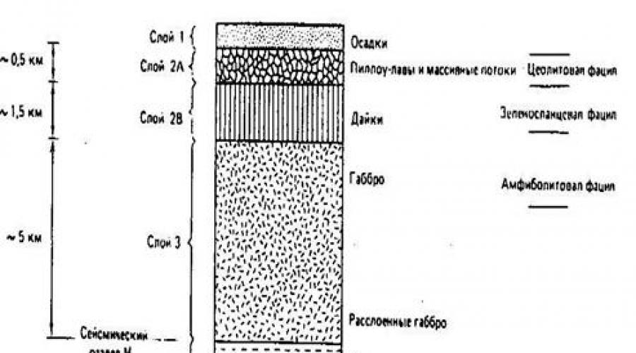
Oceanic bark It has a 3-layer structure (from top to bottom) (Fig. 2.7.1):
1st layer Posted by sedimentary rocks, in deep-water basins not exceeding 1 km and up to 15 km near the continents.
Fig. 2.7.1. The schemes of the structure of the earth's crust. I - Continental Cora, Layers: 1 - sedimentary, 2
- Essential-metamorphic, 3 - granulito-basite, 4 - peridotitis of the upper mantle. II - Oceanic cortex, layers: 1 - sedimentary, 2 - basalt love, 3 - complex parallel ducks, 4 - Gabbro, 5 - peridotitis of the upper mantle. M.- Border Mochorovichich
Breeds are represented by carbonate, clay and siliceous rocks. It is important to emphasize that nowhere in the oceans the age of precipitation does not exceed 170-180 million years.
2nd layer Comprehensible, mainly basalt Pillow (custoded) by lavami, with subtle precipitation of sedimentary rocks. At the bottom of this layer there is a peculiar complex of parallel dyes of basalt composition, which served the supplying channels for custoded lav.
3rd layer It is represented by crystalline magmatic rocks, mainly the main composition is a gabbro and less than the ultrasound, located in the lower part of the layer, which is deeper than the surface M and the upper mantle.
It is very important to emphasize that the oceanic type bark is developed not only in the oceans and deep-water depressions of the inland seas, but also meets in folded belts on land in the form of fragments of the breeds of the optic association, Paragenesis (Songness) of which (Silicon breeds - basalt lava - basalt and ultrasound The breed) was first allocated in the 20s of the twentieth century. Taintinman in the Ligurian Alps at the SZ Italy.

Fig. 2.7.2. The structure of the oceanic crust.
Continental earth bark Also has a 3-membered structure, but its structure is different (from top to bottom):
1st sedimentary volcanogenic layer It has a capacity of 0 on platform panels up to 25 km in deep depressions, for example, in the Caspian. The age of the sedimentary layer fluctuates from the early proteodes to Quaternary.
2nd layer Educated by various metamorphic rocks: crystalline shale and gneis, as well as granite intrusions. The power of the layer will change from 15 to 30 km in various structures.
3rd layerForming a lower boron is composed of highly metamorphized rocks, which prevail major rocks. Therefore, it is called granulito-basite. Partially it was opened by the Kola ultra-double borehole. The lower corte has a changeable power of 10-30 km. Partition border between the 2nd and
The 3rd layer of continental cortex is fuzzy, in connection with which sometimes in the consolidated part of the cortex (below the sedimentary layer), 3, and not 2 layers are isolated.
The surface M is expressed everywhere and quite clearly jumping speeds of seismic waves from 7.5 - 7.7 to 7.9 - 8.2 km / s. The upper mantle in the lower part of the lithosphere is composed by ultrasound rocks, mainly peridotitis, as, however, and an asthenosphere, characterized by a reduced screen of seismic waves, which is interpreted as low viscosity and, possibly melting to 2-3%.
Earth's crustit is the most upper sheath of solid land and puts the planet with an almost solid layer, changing its power from 0 in some areas of the Mediter, but ocean ridges and ocean faults up to 70-75 km under high mountain structures (Haine, Lomise, 1995). The power of the cortex on continents, determined by the increase in the speed of the passage of longitudinal seismic waves to 8-8.2 km / s ( border Mochorovichich, or border Mocho), reaches 30-75 km, and in oceanic depuses 5-15 km. First type of earthbowwas named oceanicsecond- continental.
Ocean barkit takes 56% of the earth's surface and has a small capacity - 5-6 km. Three layers (Haine, Lomise, 1995) stand out in its structure.
First, or sedimentary,a layer of power no more than 1 km is found in the central part of the oceans and reaches a power of 10-15 km on their periphery. It is completely absent in the axial zones of the mid-ocean ridges. The composition of the layer includes clay, siliceous and carbonate deep-sea pelagic precipitation (Fig. 6.1). Carbonate sediments are not distributed as the critical depth of accumulation of carbonates. Closer to the continent, an admixture of a debrid material demolished from sushi appears; These are the so-called hemiplagic precipitation. The propagation rate of longitudinal seismic waves here is 2-5 km / s. The age of precipitation of this layer does not exceed 180 million years.
Second layerin its main upper part (2a) is complicated by basalts with rare and subtle aspects of pelagi-
Fig. 6.1. The incision of the lithosphere of oceans in comparison with the averaged section of ophiolite allohton. Below is a model of the formation of major unit units in the zone of ocean spreads (Hain, Lomise, 1995). Legend: 1 -
pelagic precipitation; 2 - the expanded basalts; 3 - a complex of parallel ducks (luberites); 4 - upper (non-stratified) gabbroids and gabbro-functions; 5, 6 - stratified complex (cumulates): 5 - Gabbroids, 6 - ultra-bazites; 7 - Tectonic peridotitis; 8 - basal metamorphic halo; 9 - basalt magma Change I-IV - a consistent change of crystallization conditions in a focus as removed from the spreading axis
precipitation; Basalts often possess the characteristic pillow (in cross section) separately (Pillow Lava), but the covers of massive basalts are also found. At the bottom of the second layer (2V), parallel dyashes are developed. The total capacity of the 2nd layer is 1.5-2 km, and the speed of longitudinal seismic waves is 4.5-5.5 km / s.
Third layerthe ocean bark consists of full-rolled magmatic rocks of the main and subordinate to ultrasound. In its upper part, rock type types are usually developed, and the lower part is the "strished complex", consisting of alternating gabbro and ultra-ramafitis. The power of the 3rd layer is 5 km. The speed of longitudinal waves in this layer reaches 6-7.5 km / s.
It is believed that the breeds of the 2nd and 3rd layers were formed simultaneously with the rocks of the 1st layer.
The ocean bark, or rather the ocean type cortex, is not limited to in its spread of the oceans, and also developed in deep-water basins of the outskirts of the seas, such as the Japanese Sea, South Okhotsk (Kurilskaya) Basin of the Okhotsk Sea, Filipino, Caribbean and many others
seas. In addition, there are serious reasons to suspect that in deep depressions of continents and shallow domestic internal and outbound seas of the Barents type, where the capacity of the sedimentary cover is 10-12 km or more, it is underwent the bark of the ocean type; This is evidenced by the speed of longitudinal seismic waves of about 6.5 km / s.
It was said above that the age of the cortex of modern oceans (and the outskirts) does not exceed 180 million years. However, within the limits of folded belts of the continents, we find and much more ancient, up to the Rannedokembry-Skoy, the ocean type Cour represented by the so-called officer complexes(or just ophiolita-mi). This term belongs to the German geologist G. Steinmann and was offered to them even at the beginning of the XX century. To indicate the characteristic "triads" of rocks commonly occurring together in the central zones of folded systems, namely serpentinized ultramafitis (analog layer 3), gabbro (analog layer 2B), basalt (analog layer 2a) and radioarities (layer 1 analog). The essence of this paragenesis rocks for a long time interpreted erroneously, in particular, the gabbro and hyperbasites were considered intrusive and more young than basalts and radioarities. Only in the 60s, when the first reliable information was obtained about the composition of the ocean bark, it became obvious that the Ocean was the ocean bark of the geological past. This discovery had a cardinal value for the correct understanding of the conditions for the origin of the rolling belts of the Earth.
The structures of the earth's crust of the oceans
Field of continuous distribution oceanic type crustexpressed in the relief of the Earth oceanicvpadina. Within oceanic deposits, two largest elements are distinguished: oceanic platformsand ocean orogenic belts. Oceanic platforms(or Tasha lassokraton) in the rank of the bottom have the form of extensive abissual flat or hilly plains. TO oceanic orogenic beltsthere are mid-ocean ridges that have height over the surrounding plain to 3 km (places rise in the form of an islands above the ocean level). Along the axis of the ridge, the zone of rhyps is often traced - narrow rabes width 12-45 km with a depth of 3-5 km, indicating the domination in these areas of the stretching of the earth's crust. It is characterized by high seismicity, a sharply increased heat flux, low density of the upper mantle. Geophysical and geological data suggest that the power of sedimentary cover decreases as the ridges approaching the axial zones approach, and the ocean bark is experiencing a noticeable raising.
Next large element of the earth's crust - transition zonebetween the continent and the ocean. This is the area of \u200b\u200bmaximum dismemberment of the earth's surface, where there are island Dougi., distinguished by high seismicity and modern Andesite and andesito-basalt vulcanism, deep-water gutters and deep-water depressions of the outskirts of the seas. The earthquake foci form a seismophocal zone here (Benofo-Zavaritsky zone), immersing continents. Transition zone most
brightly manifested in the western part of the Pacific Ocean. It is characterized by an intermediate type of structure of the earth's crust.
Continental bark(Haine, Lomise, 1995) is common not only within the limits of continents itself, i.e. sushi, for the possible exception of the deepest depressions, but also within the shelf areas of continental dyeing and individual sections within the ocean-microcontinent basins. Nevertheless, the total area of \u200b\u200bthe development of continental cortex is less than the ocean, and is 41% of the earth's surface. The average power of the continental bark is 35-40 km; It decreases to the outskirts of the continents and within the microcontinents and increases under mountain structures up to 70-75 km.
Generally, continental bark, as well as the ocean, has a three-layer structure, but the composition of the layers, especially the two lower, is significantly different from the observed in the ocean crust.
1. Sedimentary layertypically referred to as a sedimentary case. Its power changes from zero on the shields and less large raising of the foundation of platforms and axial zones of folded structures up to 10 and even 20 km in the platforms, advanced and intergical deficiencies of mountain belts. True, in these depressions, the bark, underlying precipitation and commonly referred consolidatedit can already be closer in nature to the ocean, than to continental. The composition of the sedimentary layer includes various sedimentary rocks of predominantly continental or shallow marine, less often than baafial (again within deep depression) of origin, as well as far
not everywhere, covers and sillas of the main magmatic rocks forming the trapping fields. The speed of longitudinal waves in the sedimentary layer is 2.0-5.0 km / s with a maximum for carbonate rocks. The age range of rocks of the sedimentary cover is up to 1.7 billion years, i.e., an order of magnitude higher than the sedimentary layer of modern oceans.
2. Top layer of consolidated barkperforms on the day surface on the panels and arrays of platforms and in axial zones of folded structures; It is opened to a depth of 12 km in the Kola well and at a significantly less depth in wells in the Volga-Ural region on a Russian stove, on the plane of the US Midthontinent and on the Baltic Shield in Sweden. The gold mining mine in South India took place on this layer to 3.2 km, in South Africa to 3.8 km. Therefore, the composition of this layer, at least its upper part, in general, a well-known-major role in its addition play various crystal slates, gneiss, amphibolites and granites, and therefore he is often referred to as Genisov. The speed of longitudinal waves in it is 6.0-6.5 km / s. In the foundation of young platforms, having a Rifezo-Paleozoic or even the Mesozoic age, and in part and in the inner zones of young folded structures, the same layer is complicated by less severe-fluid (green-plating facies instead of amphibolito) rocks and contains less granites; Therefore, here it is often called granite-metamorphic layerand the typical rates of longitudinal will in it are about 5.5-6.0 km / s. The capacity of this cortex layer reaches 15-20 km on platforms and 25-30 km in mountain structures.
3. Bottom layer of consolidated bark.It was originally assumed that between the two layers of the consolidated bark there is a clear seismic border, which received the name of its primary-retainer-German geophysics-title of the border of the conrad. Drilling just mentioned wells questioned the existence of such a clear boundary; Sometimes instead of her, the seismic detects in the cortex, and two (to 1 and k 2) borders, which gave the base to highlight two layers in the lower cortex (Fig. 6.2). The composition of the rocks, the lower bark, as noted, is not known enough, as it has not been achieved well, and fragmentary is exposed on the surface. Based

Fig. 6.2. The structure and power of the continental bark (Haine, Lomise, 1995). BUT - main types of seismic data: I-II - Ancient Platforms (I - Shields, II
Synclises), III - shelves, IV-olive orogens. K 1, to 2-pieces of conrad, M-surface Mochorovichich, speeds are indicated for longitudinal waves; B - histogram of the distribution of power of the continental bark; B - profile of generalized strength
general considerations, V. V. Belousov came to the conclusion that in the lower cortex should prevail, on the one hand, rocks located at a higher level of metamorphism and, on the other side, the breed of more main composition than in the upper crust. So he called this layer of the crust gra-nulit-Bazitov.Belousov's assumption is generally confirmed, although exposures show that not only basic, but also acidic granulites are involved in the addition of the lower bark. Currently, most geophysicists distinguish the upper and lower bark on another basis, according to their excellent rheological properties: the top bore is rigid and fragile, lower-plastic. The speed of longitudinal waves in the lower Core is 6.4-7.7 km / s; Belonging to the core or mantle of the bottom of this layer with rates of more than 7.0 km / s is often controversial.
Between two extreme types of earthly bark-ocean and continental - there are transitional types. One of them - suboxian bark -it is developed along the continental slopes and fit and, possibly, the bottom of Kotlovin satisfies some not very deep and wide inland and inland seas. The subox bark is a thinned up to 15-20 km and the permeated dikes and silems of the main magmatic breeds continental
cora. It opened a well deepwater drilling at the entrance to the Gulf of Mexican and naked on the Red Sea coast. Another type of transitional bark - subcontinental- Creating in the case when the ocean bark in ensima-tichetic volcanic arcs turns into continental, but still does not reach full "maturity", having a reduced, less than 25 km, with a lower degree of consolidation, which is reflected in the reduced seismic wave rates - Not more than 5.0-5.5 km / s in the nizakh bark.
Some researchers allocate two more types of ocean bark as special types, which have already been discussed above; This, first, thickened to 25-30 km the ocean bark of the inner lifts of the ocean (Iceland, etc.) and, secondly, the ocean type Cora, "prescribed" powerful, to 15-20 km, a sedimentary case (Caspian Wpadina and Dr.).
The surface of Mochorovichich and the composition of the top mantii.The boundary between the bark and mantle, usually seismically quite clearly expressed by the jump rack of longitudinal waves from 7.5-7.7 to 7.9-8.2 km / s, is known as the surface of Mochorovichich (or just Mocho and even M), by name Installed its Croatian geophysics. In the oceans, this border responds to the transition from the stripping complex of the 3rd layer with the predominance of gabbroids to solid serpentine-bath peridotitis (Harzburgitis, Lersoliths), less often do thits, in places speakers to the bottom surface, and in the rocks of Sao Paulo in the Atlantic against Brazil's shores And on about. Bar Bargad in the Red Sea, towering over the surface
stew ocean. The tops of the ocean mantle can be observed in places on land as part of the bottoms of ophiolite complexes. Their power in Oman reaches 8 km, and in Papua New Guinea, perhaps even 12 km. They are folded by peridotitis, mostly Garzburgitis (Haine, Lomise, 1995).
The study of inclusions in the lavs and kimberlites from the tubes shows that the upper mantle is mainly complex under the continents, both here and under the oceans in the upper part these are spinel peridotitis, and lower-pomegranate. But in the continental mantle, according to the same data, except for peridotitis, there is an eclogite in the subordinate quantity, that is, the deep-movable major rocks. Eclogites can be meta-morphic relics of the ocean bark, latter in the mantle in the process of a hemp of this bark (subduction).
The upper part of the mantle is repeatedly depleted by a number of components: silica, alkalis, uranium, thorium, rare lands and other non-coherent elements due to the smelting of basalt ground crust. This "exhausted" ("depleted") mantle extends under continents to a greater depth (covering the entire or almost all of its lithospheric part) than under the oceans, replacing the deeper "non-involved" mantle. The average primary composition of the mantle should be close to the spinel lersoli -to or hypothetical mixture of peridotitis and basalt in the proportion of 3: 1, named Australian scientist A. E. Ring Wood pyratite.
At a depth of about 400 km, the rapid increase in the speed of seismic waves begins; From here to 670 km
erased golitsyn layer,named so in honor of the Russian seismologist B.B. Golitsyn. It is highlighted as a middle mantle, or mesosphere -transition zone between the upper and lower mantia. The increase in the velocities of the elastic oscillations in the Golitsyn layer is due to an increase in the density of the mantle substance by about 10% due to the transition of some mineral species to others, with a more dense packaging of atoms: olivine in the spinel, pyroxen in the grenade.
Lower mantle(Haine, Lomise, 1995) begins with a depth of about 670 km. The lower mantle must be folded in the main perovskite (MGSIO 3) and Magnesii-Tom (Fe, Mg) O - products of further changes in minerals, compliant mantle. The core of the Earth in its external part, according to the seismology, is liquid, and internal and again solid. Convection in the outer core generates the main magnetic field of the Earth. The composition of the kernel with an overwhelming majority of geophysicists is accepted by iron. But again, according to experimental data, it is necessary to admit some nickel intake, as well as sulfur, or oxygen, or silicon to explain the reduced kernel density compared with a certain iron.
According to seismism, surface kernelit is uneven and forms protrusions and depressions with an amplitude of up to 5-6 km. At the border of the mantle and the kernels, the transition layer with the index D "(the bark is indicated by the index A, the upper mantle-in, middle-C, the bottom - d, the upper part of the lower mantle D"). The power of the layer D "places reaches 300 km.
Lithosphere and asthenosphere.Unlike the cortex and the mantle, allocated according to geological data (for real composition) and seismology data (on the racing of seismic wave rates on the border of Mochorovich), a lithosphere and an asthenosphere-concept of purely physical, or rather rheological. The initial base for the release of an asthenosphere - weakened, plastic shell. The striking more rigid and fragile lithosphere was needed to explain the fact of the isostatic equilibration of the bark found when measuring gravity at the foot of the mountain structures. It was originally expected that such structures, especially such ambitious as Himalayas, should create excess attraction. However, when in the middle of the XIX century. The corresponding measurements were made, it turned out that such attraction is not observed. Consequently, even large irregularities of the terrestrial surface of the earth's surface are compensated, balanced at the depth so that at the level of the earth's surface, there are no significant deviations from the average gravity. Thus, the researchers came to the conclusion that there is a general desire of the earth's crust to balance due to the mantle; The phenomenon is called from-style(Haine, Lomise, 1995) .
There are two ways to implement isostas. The first is that the mountains have roots immersed in the mantle, i.e., the isostasy is provided by the variations of the power of the earth's crust and the lower surface of the latter possesses the relief, reverse relief of the earth's surface; This is the hypothesis of English Astronoma J. Erie
(Fig. 6.3). In a regional scale, it is usually justified, since mountain structures really have a thicker bark and the maximum thickness of the cortex is observed among the highest of them (Himalayas, Andes, Ginda-Kush, Tien Shan, etc.). But another mechanism for implementing isostasis is possible: areas of elevated relief must be complexed less dense rocks, and the areas are reduced-more dense; This is the hypothesis of another English scientist-J. Pratt. In this case, the sole of the earth's crust may even be horizontal. The equilibrium of the continents and the oceans is achieved by a combination of both the bark mechanisms under the oceans and much thinner, and noticeably tight than under the continents.
Most of the earth's surface is in a state close to isostatic equilibrium. The greatest deviations from the isostasy-isostatic anomalies are detected by island arcs and the deep-water gutters conjugate.
In order for the desire for isostatic equilibrium to be effective, i.e., under the additional burden, the bark was immersion, and when removing the load - its lift, it is necessary that under the crust existed a rather plastic layer capable of flowing from the areas of high geostatic pressure in the region reduced pressure. It is for this layer, originally dedicated hypothetically, an American geologist J. Barrell and offered a name in 1916 asthenospherewhat Oz starts a "weak shell". This assumption was confirmed only much later, in the 60s, when the seismic

Fig. 6.3. The schemes of the isostatic equilibrium of the earth's crust:
but -j. Erie b -on J. Prattu (Haine, Koronovsky, 1995)
logs (B. Gutenberg) existed at some depth under the crust of the zone of lowering or lack of increasing, natural with increasing pressure, seismic waves. In the future, a different method of establishing an asthenosphere-method of magnetothel-luric sensing appeared, in which the asthenosphere shows itself as a zone of lowering electrical resistance. In addition, the seismologists revealed another sign of asthenosphere - increased decays of seismic waves.
Asthenosphere also belongs to the leading role in the movements of the lithosphere. The flow of an asthenospheric substance carries the lithospheric plate plates behind you and causes their horizontal movements. The surface lifting of the asthenosphere leads to the lithosphere lifting, and in the limiting conclusion, to break its continuity, the formation of sliding and lowering. The latter also leads an outflow of asthenosphere.
Thus, of two shells that make up the teach tonon desfer: an asthenosphere is active, and a lithosphere is a relatively passive element. Their interaction is determined by tectonic and magmatic "life" of the earth's crust.
In the axial zones of the mid-ocean ridges, especially in the East-Pacific raising, the roof of the asthenosphere is at a depth of only 3-4 km, i.e. the lithosphere is limited only to the top of the bark. As you move towards the periphery of the oceans, the thickness of the lithosphere increases due to
the lower bark, and mostly the tops of the mantle and can reach 80-100 km. In the central parts of the continents, especially under the shields of ancient platforms, such as Eastern European or Siberian, the thickness of the lithosphere is already measured already 150-200 km and more (in South Africa 350 km); According to some ideas, it can reach 400 km, that is, here the entire upper mantle above the Golitsyn layer must be part of the lithosphere.
The difficulty of detecting an asthenosphere at depths of more than 150-200 km has breeded in some explorers in its existence under such areas and led them to an alternative representation that the asthenosphere as a solid shell, i.e., it is the geosphere, which does not exist, and there is a series of separated "asthenolyns " With this conclusion, which could be important for geodynamics, it is impossible to agree, since it is these areas that demonstrate a high degree of isostatic balance, because they include the above examples of the regions of modern and ancient glaciation-Greenland and others.
The reason that the asthenosphere is not easy to detect everywhere, is obviously in changing its viscosity but Lathers-Lee.
Basic structural elements of the earth's crust of continents
On the continents there are two structural elements of the earth's crust: platforms and moving belts (historical geology, 1985).
Definition:platform- a stable hard part of the earth's crust of continents having an isometric shape and a two-storey structure (Fig. 6.4). Lower (first) Structural floor - crystal Fundamrepresented by strongly deployed metamorphiced rocks that are broken by intrusions. Upper (second) Structural floor - Hollow Surning sedimentary case, weakly acid and non-petamorfzed. Outputs on the day surface of the lower structural floor are called shield. Plots of the foundation, overlapped by a sedimentary case are called stove. The power of the sediment covers of the plate is the first kilometers.
Example: On the Eastern European Platform, two shields (Ukrainian and Baltic) and Russian stove are distinguished.
Structures of the second floor platform (cover) There are negative (deflection, syneclides) and positive (en-tecline). Synclises have a sword shape, and antellize is an inverted saucer. The power of deposits is always larger on the synclise, and on the antelase - less. The dimensions of these structures in the diameter can reach hundreds or first thousand kilometers, and the fall of the layers on the wings is usually the first meters per 1 km. There are two definitions of these structures.
Definition:syneclation is a geological structure, the drop in the layers of which is directed from the periphery to the center. Antecus is a geological structure, the drop in the layers of which is directed from the center to the periphery.
Definition:syneciasis - geological structure, in the core of which younger deposits come out, and at the edges

Fig. 6.4. Platform structure scheme. 1 - Folding foundation; 2 - platform case; 3 Faults (Historical Geology, 1985)
- more ancient. The antecration is a geological structure, in the core of which are more ancient deposits, and in the edges - younger.
Definition:progibib is an elongated geological body having a concave shape in cross section.
Example:the Russian Plate of the Eastern European Platform is allocated anteclzyme(Belarusian, Voronezh, Volga-Ural, etc.), syncles(Moscow, Caspian et al.) And the deflection (Ulyanovsk-Saratovsky, Pridnestrovsko-Knischorsky, etc.).
There is a structure of the lower horizons of the cover - AV-LAKENA.
Definition:avlacogen is a narrow elongated wpadin stretching through the platform. Avlacogens are located at the bottom of the upper structural floor (cover) and can reach long to hundreds of kilometers, and tens of kilometers in width. Austcogens are formed under horizontal stretching. It accumulates powerful precipitation strata, which can be crumpled into creases and close in composition to the formations of miogosynclinal. Basalts are present at the bottom of the cut.
Example:Pachelm (Ryazan-Saratovsky) Avlako-gene, Dnieper-Donetsk Avlacogen of the Russian Plate.
The history of the development of platforms. In the history of development, three stages can be distinguished. First- geosyncline, on which the lower (first) structural element (foundation) is forming. Second- Avlacogenic, on which accumulation is accumulated depending on the climate
red color, sector or coalwicked precipitation in av-lactices. The third- slab, on which sedimentation occurs on a significant area and forms the upper (second) structural floor (plate).
The process of accumulation of precipitation, as a rule, occurs cyclically. First accumulate transgressivemarine territianformation, then - carbonateformation (maximum transgression, Table 6.1). With regression under the conditions of the arid climate is formed solenous Red Color-Nayaformation, and in the conditions of the humid climate - Palsy-Sky correctedformation. At the end of the sedimentation cycle, precipitation is formed continentalformation. At any time, the stage can be interrupted by the formation of the trapping formation.
Table 6.1. Plain accumulation sequence
formations and their characteristics.
End of Table 6.1.
For mobile belts (folded areas)characteristic:
linearity of their contours;
huge power of accumulated deposits (up to 15-25 km);
restaurantthe composition and capacity of these deposits by stretchfolded region I. sharp changes in its stretch;
availability peculiar formationscomplexes of rocks formed at certain stages of development of these areas ( aSPID, fleesheva, spirekeratofova, mOLASSOVAand other formations);
intensive effusive and intrusive magmatism (large granite intrusion-batolytes are particularly characteristic);
strong regional metamorphism;
7) strong folding, abundance of faults, including
nadvigov, pointing to the domination of compression. Folded areas (belt) occur on the place of geosynclinal areas (belts).
Definition: Geosyncline(Fig. 6.5) is the moving area of \u200b\u200bthe earth's crust, in which powerful sedimentary and volcanogenic strata were initially accumulated, then their crumpled occurred in complex folds, accompanied by the formation of faults, the introduction of intrusions and metamorphism. In the development of geosynclinal distinguishes two stages.
The first stage(geosynclinal itself)it is characterized by the predominance of lowering. Large power of precipitationin geosynclinal - it is the result of stretching of the earth's crustand its bending. IN the first half of the firststagessand-clay and clay sediments are accumulated (as a result of metamorphism, they are then forming black clay shale allocated in aSPIDformation) and limestone. Bending can be accompanied by gaps, according to which the magma of the main composition rises and is poured under the underwater conditions. The emerging rocks after metamorphism, together with the accompanying submulcanic formations give spilite-keratoffformation. At the same time, siliceous rocks are usually formed, jasper.

oceanic
Fig. 6.5. The scheme of the structure of geosynk-
linal on a schematic context through the Zonda arc in Indonesia (structural geology and tectonics of plates, 1991). Legend: 1 - precipitation and sedimentary breeds; 2 - volcual
breeds; 3 - foundation of continent-metamorphic breeds
Specified formations accumulate at the same time, but on different squares. Accumulation spilito-keratofirovathe formation usually occurs in the inside of geosynclinal - in eVGOSINKLINAL. For eVGEO-sinclinecharacterized formation of powerful volcanogenic thickness, usually the main composition, and the introduction of the intrusion of gabbro, diabases and ultrasound rocks. In the edge of geosynclinal, at its border with the platform, usually arranged moogosynclinal.It accumulates mainly terrigenous and carbonate strata; Volcanic breeds are absent, intrusion is not typical.
In the first half of the first stagemost geosyncline is sea with significantdepths. The proof is the fine grain of precipitation and the rare finds of fauna (mainly necton and plankton).
TO middle of the first stagedue to different speeds of lowering in various parts of geosynclinal areas are formed relative lifting(intrageaantics Linal) I. relative lowering(intragosinclina Lit). At this time, the introduction of small intrusions of plagiogrants can occur.
In afternoonas a result of the appearance of the inner raises, the sea in geosynclinal with merge. now this archipelagoseparated by straits. Sea due to crosses occurs on adjacent platforms. Limestones are accumulated in geosynclinal, powerful sandy-clay rhythmically constructed strata fleshfOR-216.
meciation; There is an outpouring of the Love of the Middle Foreign porfirovoyformation.
TO end of the first stageintragosyncline disappear, intrageoanticalities merge into one central lift. This is a common inversion; It corresponds the main phase of foldsin geosynclinal. Folding is usually accompanied by the introduction of large synorogenic (simultaneous folding) granite intrusions. There is a crushing of rocks into the folds, often complicated by sugges. All this causes a regional metamorphism. At the site of intrageosynclinal arises sincline- complex structures of a synclinal type are complex, and at the site of intrageantics anticlinories. Geosyncline "closes", turning into a folded area.
In the structure and development of geosynclinal, a very important role belongs deep faults -for a long time of living gaps that dissect all the earthly bark and go to the upper mantle. The deep faults define the contours of geosynclinal, their magmatism, the separation of geosynclinal on the structural-facies zones, differing in precipitation, their power, magmatism and the nature of the structures. Inside geosynclinal sometimes allocate middle arrays,limited deep faults. These are blocks of more ancient folding, folded rocks of the base on which geosynclinal laced. In the composition of precipitation and their capacity, the median arrays are close to platforms, but they are distinguished by strong magmatism and folding rocks, mainly at the edges of the array.
The second stage of development of geosynclinecalled orogenicand is characterized by the predominance of raising. Cepponation occurs on limited areas along the periphery of the central raising - in edge deficientthere are geosynclinal and platforms and platforms and partially superimposed on the platform, as well as in the intermore deflection, which is sometimes generated within the central raising. The source of precipitation is the destruction of the constantly receding central raising. In the first halfsecond Stagethis raising probably has a hilly relief; With its destruction, marine, sometimes lagoon precipitates are accumulated, low Molessformation. Depending on climatic conditions, this may be corrected paralyticor solenosnytop. At the same time, large granite intrusions - baatoliths usually take place.
In the second half of the stagethe rate of receding of the central raising increases sharply, which is accompanied by its split and the collapse of individual sections. This phenomenon is explained by the fact that due to folding, metamorphism, the introduction of the folding area (no longer geosynclinal!) It becomes tough and reacts to the continuing raising. The sea leaves this territory. As a result of the destruction of the central raising, which at that time was a mountainous country, the continental thumbs are accumulated, forming upper Molassesformation. The splitting of the arch part of the rise is accompanied by terrestrial volcanism; This is usually the lava of sour, which together with
subvocanic formations are given porfirovaformation. With it there are fractured alkaline and small acid intrusions. Thus, as a result of the development of geosynclinal, the power of the continental crust increases.
By the end of the second stage, the folded mountain area, which arose on the place of geosynclinal, is destroyed, the territory is gradually aligned and becomes a platform. The geosynclinal from the accumulation area turns into a region of destruction, from the moving territory - into a low-propelled rigid aligned territory. Therefore, the amplitudes of movements on the platform are small. Usually the sea, even small, covers extensive squares here. This territory is no longer experiencing such strong bending, as before, therefore, precipitation capacity is significantly less (an average of 2-3 km). The lowering is repeatedly interrupted, therefore, frequent interruptions are observed in sedimentacoplah; Then the weathelation bark can be formed. Does not and energetic raises accompanied by folding. Therefore, newly formed low-power, usually shallow sediments on the platform are not metamor-fisovans and go horizontally or weakly obliquely. The erupted rocks are rare and are usually represented by terrestrial outlines of the lava of basalt composition.
In addition to the geosynclinal model, there is a model of tectonics of lithospheric plates.
Lithospheric plate tectonics model
Tectonics plates(Structural geology and tectonics of plates, 1991) is a model that is designed to explain the observed pattern of distribution of deformations and seismicity in the outer shell of the Earth. It is based on extensive geophysical data obtained in the 1950s and 1960s. Theoretical bases of plate tectonics are based on two prerequisites.
The most external sheath of the Earth, called lithosphere,directly sits on the layer, called aCtENOSPHERE,which is less durable than a lithosphere.
The lithosphere is divided into a number of rigid segments, or plates (Fig. 6.6), which are constantly moving relative to each other and the surface area of \u200b\u200bwhich also changes continuously. Most of the tectonic processes with intensive energy exchange acts on the borders between the plates.
Although the power of the lithosphere cannot be measured with great accuracy, the researchers agree that inside the plates it varies from 70-80 km under the oceans to the maximum value of more than 200 km under some parts of the continents with an average value of about 100 km. The lithospheric asthenosphere is covered down to a depth of about 700 km (the limiting depth of the distribution of decades of deep-focus earthquakes). Its strength grows with depth, and some seismologists believe that its lower boundaries

single lines - transform faults (shifts); The grip covered areas of continental cortex exposed to active fault (structural geology and tactics, 1991)
ca is located at a depth of 400 km and coincides with a small change in physical parameters.
Borders between slabsdivided into three types:
divergent;
convergent;
transformes (with shifts on strike).
On the divergent boundaries of the plates represented mainly by rifts, the lithosphere neoplasm occurs, which leads to the opening of the oceanic bottom (spreading). On the converged boundaries, the litosphere plates is immersed in the asthenosphere, i.e. is absorbed. On transform borders, two lithospheric plates slide relative to each other, and the substance of the lithosphere is not created on them and does not destroy .
All lithospheric plates are continuously moved relative to each other.. It is assumed that the total area of \u200b\u200ball plates remains unchanged for a considerable period of time. With sufficient distance from the outskirts of plates, horizontal deformations inside them are insignificant, which makes it possible to count hard. Since displacements on transform faults occur along their stretch, the movement of the plates should be parallel to modern transform faults. Since all this happens on the surface of the sphere, then in accordance with the Euler theorem, each site of the slab describes a trajectory equivalent to rotation on the spherical surface of the Earth. For the relative movement of each pair of plates at any time you can define an axis, or a pole of rotation. As it removes from this pole (up to the corner
distance in 90 °) Spreading velocity, naturally, increase, but the angular speed for any given pair of plates relative to their pole of rotation is constant. We also note that in geometrically, the poles of rotation are the only for any pair of plates and are not connected with the pole of the rotation of the Earth as the planet.
Tectonics Plates is an effective model of proceeds occurring in the crust, as it consists in well-known observation data, gives an elegant explanation of previously unrelated phenomena and opens up opportunities for forecast.
Cycle Wilson(Structural geology and tectonics of plates, 1991). In 1966, Professor Wilson from Toronto University published an article in which he argued that the continental drift was taking place not only after the early-mesozoic split of Pangaei, but also in Dopandea times. The cycle of disclosure and closure of oceans relatively adjacent continental outlets is now called wilson's cycle.
In fig. 6.7 shows a schematic explanation of the basic concept of Wilson cycle in the framework of the ideas about the evolution of lithospheric plates.
Fig. 6.7, and represents beginning of the Wilson cycle– the initial stage of the split of the continent and the formation of the accretion margin of the plate.It is known that hard

Fig. 6.7. Wilson Ocean Development Cycle Scheme as part of the evolution of lithospheric plates (Structural Geology and Tectonic Plate, 1991)
the lithosphere covers a weaker, partially molten asthenosphere zone - the so-called layer of low speeds (Fig. 6.7, b) . When continuing the separation of continents, a rift valley is developing (Fig. 6.7, 6) and a small ocean (Fig. 6.7, B). These are the stages of the early opening of the ocean in the Wilson cycle. Suitable examples serve African Rift and the Red Sea. With the continuation of the drift of broken continents, accompanied by the symmetric accretion of the new lithosphere on the outskirts of the plates, on the boundary of the continent with the ocean, due to the erosion of the continent, the shelf precipitations accumulate. Fully formed ocean(Fig. 6.7, d) with the median ridge on the border of the plates and the developed continental shelf is called atlantic Ocean.
From observations of oceanic chutes, their connection with seismicity and reconstruction in the figure of oceanic magnetic anomalies around the gutters are known that the oceanic lithosphere is dismembered and immersed in the mesosphere. In fig. 6.7, d.shown ocean with stovehaving simple outskirts of increment and absorption of lithosphere, - this is the initial stage of the closure of the oceanin wilson Cycle. The dismemberment of the lithosphere next door to the continental outskirt leads to the transformation of the latter in the orogen of the Andoga type as a result of tectonic and volcanic processes occurring on the absorbing border of the plates. If this dismemberment occurs at a considerable distance from the continental outskirts towards the ocean, the island arc type of the Japanese islands is formed. Oceanic absorptionlithosphereleads to a change in geometry of plates and at the end
ends K. the complete disappearance of the accreational outskirts of the plate(Fig. 6.7, e). During this time, the opposite continental shelf can continue to grow, turning into a half-bowel of the Atlantic type. As the ocean cuts, the opposite continental outlet ultimately involves the plate absorption mode and participates in the development accreservation Orogen of the Andog-type. This is an early stage of collision of two continents (collisia) . In the next stage, thanks to the buoyancy of the continental lithosphere, the absorption of the plate stops. The lithospheric plate is taken off at the bottom, under the growing Himalayan type orogen, and comes finishing Orogenous Stagewilson cyclewith a ripe mountain beltrepresenting the seam between the newly connected continents. Antipode acrection Orogen of Anka typeis an collizional Orogens of the Himalayan type.