Regional characteristics of the world. America
South America: geographical position. Two mainland - South and North America - form a single part of the world under the general name America. These continents are interconnected by the Panaman Clever, through which in 1920 there was a ship the shipping Panaman channel connecting the quiet and atlantic oceans. South America is located in the western hemisphere and is washed by the waters of the quiet (in the west) and the Atlantic (in the north and east) of the oceans. The area of \u200b\u200bthe mainland approximately 18 million sq.km.. According to its form, South America looks like a triangle, narrowing to the south. The length of South America from north to south on the 70s degree ZD - 7350 km, and from west to east to 10th degrees S.Sh. - 4655 km.
Extreme points of South America:
- North - Cape Galinas 12 ° 25 'S.Sh., 71 ° 39' ZD
- Western - Cape Parinas 4 ° 40 'Yu.Sh., 81 ° 20' ZD
- Eastern - Cape Kabu Branka 7 ° 10 'Yu.Sh., 34 ° 47' ZD
- South - Cape Froord 53 ° 54 'Yu.Sh., 71 ° 18' ZD
In the east, the mainland is washed by water Pacific Ocean, in the north and west - Atlantic. The coastline is very weak. Only in the south-east there are several not very large bays: La Plata, San Mathias, San Jorge and Bayy-Grande. In the north is the only Caribbean Sea.
Relief and geological structure.
South America's relief is represented by plans and plateales in the east and mountain ranges in the west of the mainland. The relief of the eastern part is the ancient South American platform. It formed large lowland plains - Amazonian, Orinokskaya, La Plati, folded by strata marine and continental precipitation. The Brazilian and Guiangic Highlands height from 500 to 2500 m flames with a height of 500 to 2500 m are confined to the shields (elevated areas of the platform). Finding of the earth's crust.
In the west, the mainland Andes, or Andiy Cordillera, stretched 9,000 km from the north to south, separating the rest of the continent from the Pacific Ocean. It is a folded area of \u200b\u200bthe Alpine age; It is a continuation of the North American Cordillere and consists of parallel ridges. Between the ridges there are central Andiy Highlands and Plateau. The population processes in the Andes did not end, so there are frequent earthquakes and volcanic eruptions.
The largest vertices
: Akonkagua - 6960m (Argentina), Okhos del Salado - 6880m (Chile), Tupungato - 6800m (Argentina-Chile), Wascaran - 6768m (Peru), Ankuma - 6550m (Bolivia), Ilimani - 6402m (Bolivia).
The largest volcanoes
: Lewlyillo - 6723m (Argentina-Chile), Sakham - 6520m (Bolivia), Koropuna - 6425m (Peru), San Pedro - 5974m (Chile).
Climate.
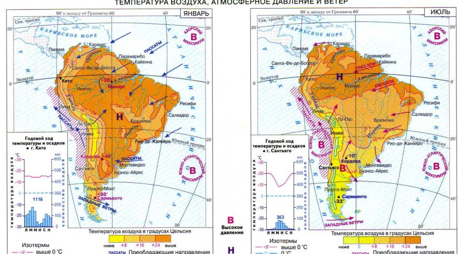
The geographical position and configuration of the mainland determine the production of a large amount of heat throughout the year. South America - the most wet mainland on the ground. Many moisture bring from the Atlantic Ocean passat. The road to air masses from the Pacific Ocean Block Andes.
South America is located in equatorial, subequatorial, tropical, subtropicaland moderate Climatic belts.
Most of the Amazonian lowland and the northeastern coast of the mainland are located in equatorial belt. Air temperature during the year + 25-28 ° C. The amount of precipitation from 1500 to 3500 mm, in the foothills of the Andes - up to 7000 mm.
Subscance belt The northern and southern hemispheres are connected on the east coast, bordering the equatorial climatic belt. There is a seasonality in the distribution of precipitation. A large number of them is 2000 mm - falls in summer. The rainy season in the northern hemisphere falls for the period from May to December, in the southern hemisphere - from December to May. Air temperature +25 ° C. Winter comes with the arrival of tropical continental air. Precipitation practically does not happen; Air temperature +20 ° C.

Tropical climatic belt.
Located only in the southern hemisphere. Air temperature +20 ° C. It is divided into two types of climate. Wet tropical climateforms in the east and south-east of Brazilian Highlands under the influence of Passats bringing moisture. The precipitation is less than in the subequatorial belt. In the direction to the West, the amount of precipitation decreases and formed dry tropical climates. The Cold Peruvian current has a great influence. The temperature inversion occurs: the air is saturated with moisture, but is very cooled, as a result of precipitation does not fall. Here is the coastal desert Atakama.
Subtropical belt located south of July 30. sh., within its limits, three types of climate are formed. On the west coast subtropical Mediterraneanthe climate with a dry non-quad summer (+20 ° C) and a wet warm winter (+10 ° C, overcast rainy weather prevails). With the promotion of the mainland climate becomes continental subtropical. Precipitation falls only 500 mm. On the east coast is formed subtropical wet climates: Summer Temperature January +25 ° C, and the winter temperature of July +10 ° C, precipitation falls to 2000 mm per year.
Moderate climatic belt located South 40є Yu.Sh. On the west coast is formed sea moderate typeclimate: warm wet winter (+5 ° C), wet cool summer (+15 ° C); precipitation - up to 2000 mm or more. In the eastern belt - moderate continental typeclimate: Winter is colder (0 ° C), summer is warm (+20 ° C). Precipitation - 300 mm.
In Andes is formed alpine typeclimate. Here, climatic belts replace each other by the law of vertical zonality. At the foot of the mountains, the climate does not differ from the surrounding territories. When lifting the temperature and precipitation mode changes.
Water sushi.
South America is rich in inner waters. Most rivers have a rain type of food, some get water due to melting of snow and ice in the mountains. On the territory of the mainland proceeds the largest river Earth Amazon (6400 km). The area of \u200b\u200bher river basin is equal 7 million km2. - It is almost 40% of the mainland territory. Being in the zone of high moisture, the river is full of all year. Twice a year, the river is distinguished: in May, at rains in the southern hemisphere and in October-November - in the northern hemisphere.
Unlike Amazon River Orinoco (2730 km) and Parana (4380 km) have a pronounced seasonality of the drain. The spill period on rivers falls on the summer wet season. Stacking from the Andes of the River in the upper reaches form waterfalls. At one of the tributaries, Orinoco is the highest waterfall of the world - Angel (1054 m); On one of the tributaries, Parana is a waterfall of Iguazu.
The United States of America is an interesting object for studying the general picture of the world. Industry, territory, economic and transportation of state, relief, minerals and other features of the United States of America affect our entire planet.
Geographical location of the country
US - one of the most developed states of the worldWhat is the merit and advantageous geographical location. Regarding the geography of America, most of the states are located in North America. The main areas of the country are 48 states that are connected to each other, as well as two states that do not border - Alaska and Hawaii. The state is the Federal Administrative Unit - District Columbia.
Due to the fact that the country is washed by the waters of three oceans, has a favorable transport junction with a large number of countries, which affects both the economic and geographical characteristics of the state (EGC / EGP).
It should be noted that until 1959, Hawaii and Alaska were not part of the country, until the specified year they were colonies.
 The main watershed state Located in the eastern part of the largest mountain system of the Cordiller. The main part of the lakes is in the northern edge of the country. Waters are actively used by the country for the development of hydropower, water supply states, and in water movement of goods.
In the US, there are large physiographic regions. So, at the Atlantic Ocean is Appalachi. Approaching the western part, the mountainous area is replaced by great plains. The mountain ranges are magnificently stretch closer to the west of the country, and after - rapidly break off from the coast of the Pacific Ocean.
Main river system - Mississippi River, as well as her tributaries.
Coordinates: 38 ° C. sh., 97 ° z. D., The length of the coastline is about 19,924 kilometers, the capital of the USA - Washington. There are six time zones in the country.
Borders of the USA and the area
The United States occupies an honorable position in the top five among the world's largest countries. The size of the country is approximately estimated at 9,500,900-9,800,630 kV km.
The southern part is nearing Middle America - her neighbor - Mexican United States, north adjacent to Canada, there is also a border with Russia, maritime. The state is washed immediately by three largest water objects - the oceans:
- Alaska is located in the water of the Northern Ocean.
- East of the United States is washed by the Atlantic Ocean.
- From the west of the country, the water of the Pacific Ocean can be seen.
Climate of state
One of the features of the United States You can safely call the presence of a wide variety of climatic characteristics. The length does not allow to clearly designate climatic conditions, nevertheless, most of the state refer to the subtropical climate, at the same time the temperate climate is found to the south of Alaska, it is interesting that the polar climate is found north of the same state. South Florida and Hawaii refer to the tropics, there are also semi-desert - great plains. In the regions of California, the Mediterranean climate, and the area near the Big Basin have an arid climate.
 Also a distinctive climate feature of the United States designate frequent tornadoes. March-August - the peak season of the Vortex in the central region of the country. The main cause of their appearance is the impact of air masses with different temperatures.
Another climatic disaster - Hurricanes, the season of which falls on June-December. Especially they are exposed to southern states and coast in the eastern area.
Moreover, part of the country is exposed to earthquakes. The most dangerous zone is the mountainous region of the west coast. The high activity zone of volcanoes is quite long - stretches from Alaska to the south of California. Especially large concentration of volcanoes are cascading mountains.
Natural resources
Main part of the USA It is recognized as favorable and for economic activity, and for the life of the population. Of course, the length and large area of \u200b\u200bthe state, the most different industrial resources in their depths. The country is endowed with large reserves of mining and chemical raw materials, oil, natural gas and ore. The largest gas reserves are concentrated in Alaska, as well as in the south of the country. By the way, the US oil and gas production ranks second all over the world, which opens up large economic horizons.
Iron ore, for the most part, focused on the lake top, the mining macroregion has precious metals. Leads of lead allow the state to enter into world leaders.
Nevertheless, the country's security still implies imports of some raw materials, for example: cobalt, potash salts, tin, manganese and others.
Population of the United States
 The large territory affects the fact that the United States is included in the top three of the most populated states of the world. There are about 270 million people.who are residents of the United States. But the population density per 1 km on average is only 28 people, which is significantly less than in most developed countries. The average life expectancy in the country is 80 years in women and 73 - among male representatives. The main number of inhabitants, and these are eighty percent, make up Americans of European origin.
Immigration plays a significant role in the actual population of the country. To date, the main immigrants are residents of Asian countries.
Important is the fact that the United States is included in the list of the most urbanized countries of our world. About 75% make up the townspeople. Regarding cities, in the USA there are approximately ten thousands, eight of which are millionaire cities.
The top three of the most populated regions includes:
- California (about 31 million people).
- New York (approximately 18.4 million).
- As well as Texas (about 18 million).
 It is in the United States of America that is not expected for many more snow fallsthan at any other point of the planet. More precisely - in the western states of the state.
Mount Denali is the highest point of the state (its height is 6194 meters), the lowest point on the US card is determined by the Death Valley (amounts to 86 meters).
Minimum temperaturewhich recorded in Alaska, lowered to minus 62 degrees Celsius. The maximum stake Thermometer rose in California - up to 56.7 degrees.
The United States of America occupy a huge territory, the United States area is 9520000 square kilometers. The area of \u200b\u200bthe United States is almost comparable to China's Square and divides the third place with it in the list of the largest countries of the world. First place and second, as you know, belongs to Russia and Canada, respectively.
The main part of the United States of America is the so-called "continental part of the United States", it includes 48 of the fifty states and the Federal District of Columbia, is located in the North American continent.
Separate, not continental states: Alaska, located in the north-west of North America and Hawaii, which lies on the archipelago in the Pacific Ocean.
In addition, the United States of America belongs to a number of territories in the Caribbean and the Pacific Ocean. In the Caribbean Sea - Puerto Rico and in the Pacific - Guam and the Federation of Micronesia.
The United States of America has a large ground border along the length. It takes place in the north with Canada and with Mexico in the south. Also, the United States has a marine border with Russia in Alaska.
As for the main continental part of the country, it is washed by the waters of the Atlantic Ocean in the East, the waters of the Pacific Ocean in the West and the Gulf of Mexico in the south-east. Only Alaska from the north is washed by the Northern Arctic Ocean.
USA map
Extreme Points of USA
There are extreme points of the continental part of the United States, fifty states of the United States and the entire United States.
The northernmost point of the USA
Cape Barrow, Alaska (71 ° 23 "20" s. Sh., 156 ° 28 "45" z. D.) - The northernmost point of the United States (and fifty US states)
Lake Woods, Minnesota (49 ° 23'04 "s. Sh., 95 ° 09'12" z. D.) - The northernmost point of the US continental states
The southernmost point of the USA
Atoll Rose, American Samoa (14 ° 34 "11" Yu. Sh., 168 ° 9 "10" z. D.) - The southernmost point of the United States
Lae, Hawaii (18 ° 54 "39" s. Sh., 155 ° 40 "52" z. D.) - The southernmost point of the fifty US states
Ki-West, Florida, (24 ° 32'41 "s. Sh., 81 ° 48'37" z. D.) - The southernmost point of the US continental states
The eastern point of the USA
Point Halll, Saint Crue Island, Virgin Islands USA (17 ° 45'19 "s. Sh., 64 ° 33'54" z. D.) - The easternmost point of the United States
The sail is nearby from the Atlantic coast, near the beacon West Kodddi, Maine (44 ° 48'45.2 "with. Sh., 66 ° 56'49.3" z. D.) - the eastern point of fifty US states
Lighthouse West Kodddi not far from the city of Lubek, Maine (44 ° 48'55.4 "s. Sh., 66 ° 56'59.2" z. D.) - The eastern point of the continental state of the United States
The most western point of the USA
Point Halll, Guam Island, Mariani Islands (13 ° 26'51 "s. Sh., 144 ° 37'5.5" C. D.) - The most Western point of the United States
Attu Island, Aleuta Casta, Alaska (52 ° 55'14 "s. Sh., 172 ° 26'16" C. D.) - The most western point of the fifty US states
Cape Alava, Washington (48 ° 9'51 "s. Sh., 124 ° 43'59" z. D.) - The most western point of the US continental states
An interesting fact is that the eastern and most western dotting of the country is the same name - Point Halll, as it also calls the point of Half. The point in the Virgin Islands of the United States received such a name in honor of Stewart Hasolla, who was the Minister of Internal Affairs of the country under the presidents of John Kennedy and Lindon Joneson. Point of Homolla on the island Guam was named after his brother, the US Congressman Maurice Malolla.

Sunclock, built in honor of the start of the new millennium at the point Point Halll, Saint Cruel Island, Virgin Islands USA
Interesting places in the United States of America
From the point of view of geography, the center of the entire United States, including Alaska and Hawaii, is considered the city of Bel Fur, located in the state of South Duck.
As for the continental part of the country, then the geographical center is located near the city of Lebanon, Kansas.
Mac-Kinley Mountain is considered the highest point in the United States of America, it is located 6194 meters above sea level. The lowest in the valley of death in California, below sea level by 86 meters.
The temperature in the United States is also very much due to the large territory of the country, so the lowest temperature marked in the United States was recorded on Alaska - 62.2 degrees Celsius, and the highest in the valley of death, California - + 56.7 degrees.
The most precipitation in the United States falls on Hawaii, on average over the year it drops to 1170 cm of precipitation.
The most dry climate in the Mojave desert in the south-west of America. On average, over the year, only 6.7 cm of precipitation falls.
A little bit in the details of the US geography
On the territory of the United States of America, you can find a wide variety of areas of terrain, so there are lowlands and mountain ranges.
The climatic conditions of America are also very diverse, and the Arctic cold of Alaska can be found here, and the tropical heat in Florida and Hawaii.
The United States flows many rivers, both large and small. The total flow of these rivers is approximately 1600 cubic kilometers.
The United States from time to time is subjected to natural disasters, such as floods, hurricanes and tornadoes.
For more information, see our website in the section "Geography of the United States of America".
US relief
The United States of America has a large territory and here you can meet a wide variety of relief, ranging from coastal lowlands and ending with mountain arrays.

In the continental part of the United States, eight physical and geographic regions are distinguished, and the relief of the states of Alaska and Hawaii.
US climate
The United States of America has a large and diverse territory, you can see the most different climatic zones.
One of the fundamental factors that determines the climate in the United States is the presence of an inkjet atmospheric flow here, which carries air masses and moisture from the north of the Pacific Ocean to the continent.
The presence of wet Pacific cyclones makes the possibility of heavy irrigation with rains or snow north-west coast of the country.
As for the southern regions of the country, in California, precipitation is predominantly falling out in the fall and winter. Summer here is dry and roast.
In the way of the movement of the air masses, a barrier in the form of Pacific mountains and rocky mountains occurs. Because of this, in the region of the intermountal plateau and in the western part of the Great Plains is almost always dry.
Also on the climate of the United States of America, warm tropical air flows coming here from the Atlantic and the Mexican Gulf have great influence.
Elements in the USA
The United States of America has a large territory, where there are various natural elements from time to time.
Earthquakes in the United States
Due to the fact that in the west of the country, the mountains of the Pacific coast extended the mountains included in the "Pacific Fire Ring, forming a volcanic mountain chain, this area is subject to earthquakes.
One of the largest disasters related to the earthquake occurred here on May 18, 1980. The earthquake of the amplitude of five balls on an octal scale was caused by an eruption of Saint Helens volcano, which is located in the Cascade Mountains of Wisington.
As a result of this disaster, fifty-seven people died. The element brought the destruction of more than 250 houses, 40 bridges. Many roads due to cracks lost their functional basis. So more than 100 kilometers failed. 24 kilometers of railways were damaged.
The eruption occurred in 1980 in the United States of America.
If we consider the United States from the point of view of volcanic activity in its territory, then it is worth noting several existing volcanoes in Hawaii. So here is the Kilauea volcano, which continuously spells to the surface of hot lava since 1983.
Also periodically can observe earthquakes in Alaska and the West Coast of the United States.
US time zones
Starting from 1883 in the United States of America, the concept of time zones is introduced. For the first time, time zones appeared on the countries of the country, so here it was introduced standard time and time zones.
Later in 1918, a special act was adopted by the United States Congress, which consolidated the system of time zones in the country who had previously established by that time. The law got the name "Act of Standard Time".
To date, in the United States, all issues of determining the boundaries of time zones and other issues that relate to standards of time, directly the State Department of Transport.
The transition on summer time is regulated by the federal legislation of the country.
Carat of time belts USA

Main "belts" USA
Belts are called the regions of the country, which combine the similarity of one or another characteristic.
As a rule, the names of the belts are unofficial, but their name is very popular and distributed among the population.
Today in the United States of America a large number of belts, below we describe only the most popular of them.
Biblical Belt

The United States of America or Abbreviated US is the largest country in North America. The state occupies 4th place in the area in the world and the 3rd place - according to the population. The subordination is five dozen states, one federal district and some island territories.
Geographic characteristics

The total territory of the United States is more than 9.5 million km 2. From the northern borders, the state is adjacent to Canada. The south side has a border with Mexico. Also, the United States has a maritime border from the Russian Federation in the area of \u200b\u200bBering Strait. The United States belongs to some islands in the Caribbean and the Pacific Ocean. Also, under the management of the state, there are territories with various state status, for example, Puerto Rico.
The total population of the United States is currently about 325 million people. The first tribes migrated to Alaska from Siberia about 10 thousand years ago. The current population is the descendants of European and African immigrants of the XVII-XX centuries.
Nature
The natural features of the United States of America have a significant impact on the social and economic situation of the state. Long-term formation of relief over the Millennium has left a mark on the modern history of the United States.
 The mountains
The main part of the country has a plain relief, with the exception of the Cordiller mountains and the mountain system. The Cordiller system includes a huge plateau who took the whole Western territory from Alaska to California and New Mexico. The length of the mountain ridge is more than 1.5 thousand km. The part of the cascade mountains has volcanoes of different activity and represents seismic danger. The vertices of the mountains are covered with glaciers, many rivers start their sklons. The inner belt Cordiller is also distinguished by dry lakes with a thick layer of salt. Cordillera, in general, occupy a third of the United States, and the rest of the mountains are appalaci and ancient weathered plateau.
Appalachi stretched from the north-east to the southwest and consist of two largest plateau: Cumberland in the south and allegoman in the north. The length of the mining system is equal to 2600 km. In the north-west, the mainland from the branches of Cordiller formed Alaska. It is also necessary to note the Hawaiian archipelago with a large number of underground and surface volcanoes ...
 Canyons
Canyons are sheer mountain failures formed as a result of soil erosion, moving entire formation of rocks and tectonic activity. In the United States posted the largest and well-known canyons. In particular, the Grand Canyon, formed several million years ago along the River Kolorado River in Arizona. The depth of this canyon is almost 2,000 meters, the width is 30 km, and the length is almost 450 km. The first erosion processes on this territory began 17 million years ago. They continue to lead their activity and the depth of the Grand Canyon is constantly growing. Also in Arizona is the Canyon Oak Creek, which appeared 10 million years ago. Its depth does not exceed 600 meters, and the length is 20 km. The third in popularity can be called Arizona Canyon de Shay, located in the reserve zone of the reservation of the Indian tribe Navajo. Actually, this canyon is fully controlled by Indians and is visited only with their participation. Unique canyons are available in Utah, Nevada, New Mexico ...
 Plains
The foothill plateau of Cordillera is the great plains. The height varies from 500 to 1500 meters. The plateau is a divided Valley network, some of which are very thick and are not intended for economic activities. In the northern part there are so-called bad lands without soil cover. The southern territory of the plains includes Plateau EduardS and Llano-Estakado ...
 River
River
The main stock of rivers in the United States takes place in the pools of the Northern Ice, Pacific and Atlantic Ocean. The mode of the rivers themselves is not stable, especially in the continental part. Most of the rivers located in the United States are subject to industrial exposure. For example, Susquahanna in New York or Roanok in Virginia.
The main water stream in the United States is the longest river of America - Mississippi. The pool of this reservoir is located, in particular, on the territory of Canada, and the beginning of his own takes to Nicolett Creek. Mississippi length - more than 3.5 thousand km. An important water stream is the influx of Mississippi River Missouri, which originates in the Rocky Mountains. Also through the states the Columbia River, which has a mountain flow and fed by glaciers. In the southwest river Colorado ...
 Lake
Lake
America's largest lake reservoirs should include great lakes interconnected by the straits and rivers. Their total area is 245,000 km 2. The average depth of the lakes exceeds the indicators of the North Sea. The system includes 5 large freshwater lakes and many small ones. Separately, labeled Lakes, Huron, Michigan, Erie and Ontario. In the Great Lakes area, shipping is actively developing, tourist activities for visiting small islands and Niagara Falls. It is also worth noting a major lake of the Western Hemisphere in Utah. This large salt lake does not have drain and changes its area in accordance with the level of precipitation. Large lakes are located in the states of Alaska, California, Oregon, Nevada ...
 Oceans and Sea Washing US
The land territory of the country is washed in the West by the Pacific Ocean, in the East - Atlantic, and in the north - northern ice. To the Pacific Pacific Basin in the United States includes large Columbia Rivers, Villamette, Colorado, Yukon, Qusokoku, as well as San Francisco Bay.
The northern ice ocean pool includes rivers in Minnesota and North Dakota, as well as reservoirs of Northern Alaska, for example, Kolville and Noaak. As for the Atlantic Ocean, then to its pool, namely, the Gulf of Mexico, the main part of the river flow: Mississippi, Missouri, Arkansas, Ohio, Rio Grande, Trinity.
Regarding marine water bodies it should be said that the United States is washed by Bering, Sargassov and Caribbean seas ...
 The woods
Forest vegetation takes approximately 70% of the total area of \u200b\u200bthe country. Closer to Alaska, where the tundra ends, the scaffolding of the taiga type is presented, most of which are not only not mastered, but not studied. The Cordiller Mountain System has coniferous forests, and Appalachi Mountains are wide.
At the end of the XIX century, a system of national forests was created in the United States, where resources are used in recreational and industrial purposes. Commercial use of such forests is not only permitted, but also encouraged ...
 Plants and animals USA
The presence of several natural zones with various weather conditions is caused by the existence of a rich world of flora and fauna in the United States. Here you can meet ecosystems characteristic of tundra, taiga, deserts, mixed and rainforest. The most popular trees can be called pine, cedar, oak, larch, birch, spruce. In arid territories, magnolias, rubberos, cacti and succulents grow. On the coast of the Mexican Bay, palm and citrus gardens are massively found.
The animal world of the United States practically duplicates the biological diversity of the species of Eurasia. In Tundra, you can find deer, hares, wolves, lemmings, and in Taiga - Malos, bears, badgers and raccoons. Alligators, opossums and turtles are found in mixed forests, and on the plains and in the steppes - bridges, horses, scorpions and snakes ...
 US climate
On the territory of the United States there are areas with the most different climatic characteristics. The main part of the country runs in the subtropical zone. Closer to the north moderate climate, and then the polar regions. The southern coast is represented by the tropical and Mediterranean climate. On the territory of the Great Plains climate closer to the desert. In general, the climate may vary through one belt due to the transformation of the relief, the human activity and the location of the ocean. The favorable climate of the main part of the United States contributed to the rapid settlement of the country and its development.
The disadvantage of the climatic features of the United States is a large amount of natural disasters. It is not uncommon here are hurricanes, droughts, tornadoes, floods and tsunami ...
Resources
Due to the variety of natural minerals and the active growth of industrial production, the US economy is characterized by a high level of GDP and worthy social indicators.
 Natural resources USA
The most common mineral resources of the United States include gold, mercury, iron and manganese ore, coal, copper, silver. The zinc, lead, tungsten, titanium, uranium, etc. are also found. The most important source of natural resources of America is an extensive network of rivers and lakes, as well as cordillers, great plains, canyons and lowlands. The abundance of vegetation contributes to the development of the wood processing industry ...
 Industry and agriculture USA
Industrial production of the United States includes different manufacturing industries in accordance with the territorial division. It is the industry gives at least 20% of GDP in this country. The North Atlantic States presents an easy industry, chemical - in Texas and Louisiana. It also develops production and processing of petroleum products. The National Industry Industry of the United States can be considered mechanical engineering, including automotive industry, shipbuilding, as well as atomic, aviation and rocket-space spheres.
A certain proportion of GDP provides the development of agriculture in the United States. Thus, the country of exports of fruits, corn and soy develops in the country. The agricultural processes of the United States are characterized by orientation on commodity capitalist relations, as well as a narrow specialization of each of the districts ...
Culture
 Peoples in the USA
The cultural traditions of the United States have long developed under the influence of ethnic and racial traditions of the population. A huge role here played indigenous people of Hawaii, Indians of America, African descendants and people from Europe. Fundamental symbols of world American culture can be considered cinema and TV, musical areas of type jazz and blues, as well as numerous religious holidays, literature, cooking and family values \u200b\u200b...
NORTH AMERICA.
Table 3. Demographs and socio-economic indicators of the world, North America
| Indicators | The whole world | Sulna America | Canada | USA |
| Square, thousand km 2 | 132850 | 19340 | 9976 | 9363 |
| 5930 | 304,1 | 30,2 | 273,8 | |
| Fertility, ‰ | 24 | 15 | 14 | 15 |
| Mortality, ‰ | 9 | 9 | 7 | 9 |
| Natural increase | 15 | 6 | 7 | 6 |
| 63/68 | 74/80 | 76/82 | 73/80 | |
| 62/6 | 22/13 | 21/12 | 22/13 | |
| 45 | 76 | 77 | 76 | |
| 6050 | 25090 | 21130 | 26980 |
United States (USA)
GEOGRAPHICAL POSITION. General information about the country.
- Territory area - 9.4 million km 2 - 4th place in the world, 5 hour zones: Pacific, mountain, central, east, atlantic time.
- Actually, the United States from the east to the west of 4.7 thousand km, and from north to south - 3 thousand km. In addition, the United States includes Hawaii (0.2% of the country's Square) and Alaska (16%).
- Population - 263.2 million people (1995)
- Capital - Washington.
The history of the country population.
- Saint-Augusten in Florida is the oldest settlement in the USA, based on the Spaniards in 1565. Jamestown - the first permanent English settlement at the mouth of the James River on the shores of the Cezapic Gulf - marked the beginning of the first English colony of Virginia, which belonged to the London company (the beginning of the XVII century).
- In 1620, Plymouth company organized an expedition on the Maiflower ship. There was an II English colony on the shore of the Massachusetts Bay. Following the new Plymouth, other urban settlements appeared, among which Boston raised quickly, which became the center of New England.
- The Dutch was mastered by the city of Novy Amsterdam (later New York).
- The west coast mastered the Spaniards (from the middle of XVI): Los Angeles, San Diego, San Francisco
- The French: the basin of the Great Lakes and Mississippi from the North from Canada.
- Russians: Alaska. The most southern settlement of the Russians - Fort Ross in the San Francisco area.
- In 1776, on the second continental congress in Philadelphia, the independence of 13 former English colonies and their separation from England was proclaimed. The composition of the initial states included: New York, New Hampshire, Massachusetts, Connecticut, New Jersey, Dalaver, Maryland, Pennsylvania, West Virginia, Virginia, North Carolina, Carolina, Georgia). After the war of independence, the territory of this country since 1983 officially extended from the coast of the Atlantic Ocean to the West to about the Mississippi line. Since then, as a result of wars, purchases, expansion, settlement and economic development of other territories, in the direction from the east to the west of the United States, which led to a change in the EGP and the country's PGP.
EGP countries.
- Wide Front of Maritime Borders (12 thousand km). On the island of Kruzenshtern in the Bering Strait near Ratmanov Island, the sea border is held with Russia. Beautiful natural harbor. The US outlet to the Atlantic and Pacific Oceans contributes to the economic relations with the states of the world, both in East and Western Hemisphere. Oceans separate the country from war foci in Europe and Asia, which has a positive effect on the development of the country's economy and improving the well-being of the population.
- The borders with neighboring countries (Canada and Mexico) pass mostly on conditional lines, natural frontiers do not interfere with relations with them, which contributes to the development of trade and economic relations with Canada and Mexico, which, along with the United States, are members of the Economic Customs Union of Nafta.
- Thanks to the country's position on a variety of tectonic structures and a large area of \u200b\u200bthe United States, almost all natural resources are perfectly provided.
Total assessment of the country's EGP: Favorable for the country's economic and social development, to provide economic and political influence on other countries.
Administrative and territorial division of the country and the form of a political device.
The United States is a federal state, which consists of 50 states and the Federal District of Columbia. The federation was historically. Different territories were part of the United States at different times and at different times received state status. So bought in 1867 for $ 7.2 million in Russia, Alaska received state status only in 1959 simultaneously with Hawaii (49 and 50 US states). In 1792, the residence of the President was laid on the shore of Potomak - the White House, in 1793 George Washington laid the first stone to the foundation of the Congress of the US Congress. In 1800, the President and Congress moved from Philadelphia to Washington. The Federal District Colombia was formed in 1871.
Currently, the United States is a typical presidential republic. It has a constitution, adopted in 1787 and subsequently only complemented by the amendments. The head of state is the president, elected for 5 years by universal voting. Legislative power belongs to Congress.
Natural conditions and resources of the United States.
The United States is distinguished by a variety of natural conditions and wealth of natural resources. Especially great fuel and energy resources.
Fuel and energy resources.
Coal. In terms of reliable reserves, the pools of coal are composed of 10% of the territory of the country (1.6 trillion. T).
Coalous provinces: Appalacian (coking coals and open production method prevail; As a result of extremely favorable mining and geological conditions of production, the cost of coals is much lower than in European basins), within the central plains - West and Illinoas (open and closed method) at the junction Central Plains and Rocky Mountains (Open and Independent Method of Mining), among which the largest Broaterna Baroundary Basin Fort Union.
Oil and natural gas. Proved proven reserves - 4.6 billion tons (among developed capitalist countries - 1 place) and 5.6 trillion. M3 (5th place in the world after Russia, Iran, Qatar, Saudi Arabia), respectively. For the extraction of these resources, the country takes 2 place in the world.
The largest oil and gas pools of the United States are focused on Alaska, (Pradho-Bay - a giant field, the largest in the USA), on the territory from the coast of the Gulf of Mexico (Gulf - "Bay" covers the territories of the states of Texas, Louisiana, Mississippi and Alabama) on the inner United States (Oklahoma, Arkansas, Kansas and Missouri states, the West Interior), the California pool, Michigan, Illinois and Predippalach East Pools of the United States.
Iron ores. 4th place in the world in stocks place after Brazil, Russia, China. One of the largest deposits of iron ore in the USA - Mesabi Ranj, which extends through the territory of Michigan and Mneshesota, where the folding foundation of the ancient North American platform is published on the surface - Canadian shield. A significant part of stocks make up high-quality hematites with an iron content of 50-55%. However, from the middle of the nineteenth century, when the development of the pool began, they were the main object of operation and have already been exposed to a large extent.
Copper. 2 place after Chile. Polymetallic (lead-zinc): 3 place after Canada and Australia. Phosphorites and apatity: 2 place after Morocco. Large deposits are located in Florida. Uranus: 6th place after Australia, South Africa, Niger, Brazil, Canada. By mining gold The United States is 2 place after South Africa. For production silver: 2 place after Mexico.
And also significant resources of molybdenum and tungsten in the fields of mountainous states, platinum group metals, sulfur, etc.
However, the country is still forced to import nickel, manganese, cobalt, bauxite, tin, potash salts. Poor country and reserves of aluminum ores.
Land resources.
In the central part there are prairies with fertile black soil, almost completely plowed. The west of the prairies are the dry steppe of the Great Plains, which are used under natural pastures (and partially under Pashny).
US forest science - 33%.
The main forestry industrial areas of the United States are the north-west and southeast of the country.
On the forest area, the United States ranks 4th in the world after Russia, Brazil, Canada.
Water resources.
A variety of water resources are unevenly distributed in the country. On the border with Canada is the largest lake system of the world - Great Lakes (Top, Michigan, Huron, Ontario, Erie), having a transport and water consideration. The main river system of the country is Mississippi and its influx. Left full-flowing tributaries (Ohio, Tennessee) have significant hydropower resources, and the right - Missouri, Arkansas - are used for irrigation. The mountain rivers of the Pacific Basin (Colombia, Colorado) are used both as sources of irrigation, and as sources of hydropower.
Table 4. Space Resources. Geothermal resources. Resources of tides, etc.
Recreational resources
Florida, California, etc.
US population.
Number, reproduction, composition and structure of the population.
- The third place in the world in numbers after China and India.
- Population growth rates - 0.9%
- Poland North America: 100 women 982 men
- EAN: 131 million people. (1994)
- Structure of employment in sectors: 3/28/69 (1994)
Figure 3. Age-sex pyramid of the United States.
Placing the population. Urbanization.
- The average population density is 28 people / km 2 under the Midnoyemer - 34 people / km 2. But placed unevenly. So in the northeastern areas, the population density is over 100 people / km 2, in the agrarian districts and weakly populated mountainous states from 2 to 11, and in Alaska - even less. The greatest population is characteristic of the states of California (31.2 million people, 1993), New York (18.2 million), Texas (18 million), Florida (13.7 million)
- In the US, the city is a settlement with a number exceeding 2.5 thousand people. Such - 9 thousand
- The level of urbanization in the United States is 76%. Eight millionaire cities: New York, Chicago, Los Angeles, Houston, Philadelphia, Detroit, Dallas, San Diego.
- Most (2/3) Americans live in suburbs (Surbanization, "One-story America"), the share of the black population in the central parts of the cities.
Table 5. Megalopolis USA.
- The rural population of the United States should not be confused with the population living in agricultural farms. Many of these residents are not associated with the agrarian sector. And the rural settlements themselves, very comfortable, have a complete set of urban services.
Migration of the population.
External
Every year, on average, the country enters permanent residence of 1 million people. Maximum in 1900-1914, when 13.4 million people arrived in the country.
The last 30-40 years - from Latin America (2/3) and Eastern and Southeast Asia (22%). The main stream from Mexico (Buracheros), Puerto Rico and Cuba.
Immigration structure:
1st place - near relatives
2nd place - illegal
Internal
From "snow belts" (north) in "Sunny" (south). In 1950, the ratio of the population of the North and the South correlated 55:45, in 1990 - 45:55.
Frequently, the population of California, Texas, Florida is growing faster.
National composition.
- Ethnic groups:
- US Americans - descendants of immigrants - 3/4;
- Transitional emigrant groups (not yet "naturalized") - relatively recent immigrants;
- Residents-Aborigines (Indians, Eskimos, Aleuts, Hawaiians) - about 0.8%.
In general, in the US, Americans of European origin are 80% of the country's population. The special racial-ethnic group among the US residents are negros, whose number at the beginning of the 90s amounted to about 30 million people. (12% of the population).
"Black South" (53% of the total black population of the USA): Texas, Mississippi, Alabama, Georgia. 84% of blacks live in cities. The most "Negro" from the US cities - Detroit (more than 4/5 - blacks), Washington, Chicago, New York.
The third place is occupied by Americans of Latin American origin. Only for the period from 1980 to 1990. Their share in the population of the country increased from 6.4% to 9%. Their share is especially large in Texas, California, Arizona, New Mexico, Colorado, Illinois (Mexicans), in the state of New York (Puertoricans), in Florida (Cubans).
The fourth place is occupied by Americans of Asia-Pacific origin, whose share for the period of 80-90. increased from 1.5 to 2.9%. Most of them settled in California and in the Hawaiian Islands.
The fifth place is the indigenous population. Approximately half of the Indians live in cities, half - in reservations. The total number of reservations in the United States is approaching 300. Navajo reservation in Arizona has an area of \u200b\u200b64 thousand km 2, which corresponds to the size of a rather large European country.
The share of the color population is growing. If in 1960 the ratio of "white" and "non-protected" population was 9: 1, then in 1990 this ratio was 8: 1. The color population prevails in such cities as Los Angeles, Miami, San Antonio, approaching 1/2 in Houston, New Orleans, San Francisco.
Now 14% of the population does not speak English. In the state of New York, they do not own almost 1/4, and in the state of California almost 1/3 of all residents.
According to the forecast by 2040, the proportion of the color population will be 59%.
Figure 4. Relocation of the Negro population in the USA.
USA
Industry
The United States takes 1 place in terms of industrial products (18.9% of the volume of industrial products of the world).
Table 6. US leadership
| 1st place | 2nd place | 3 (4) place |
| Metal aluminum Lead and Zinc (together) Chernovaya and refined copper | Cast iron (4) Steel Alumina WINDS FREE Gold production Silver production (4) |
|
| Mechanical engineering (1 place and volume and variety) Trucks |
Cars | Machine tool Tractor (3-4) Cameras |
| Chemical industry (and in terms of variety) Sulfuric acid Fertilizers Production of plastics, chemical fibers, synthetic rubber Pharmaceutics Wood blank Production of lumber Cellulose production Paper Production (1/3 World) |
Phosphoric fertilizers | |
| Fabrics Silk fabrics (70%) From chemical fibers (30%) Carpets Tricat Footwear | Cotton fabrics (4) | |
| Oil mining (1996) Brown coal mining Oil refining (refinery) Power generation Energy production on TPP NPPs and Geotes The largest cascade of HPP in the world on r. Colombia |
Coal mining Gas production Electricity generation for hydropower | |
| The largest shipping channel - coastal River and lake fleet By volume of cargo turnover of water transport Length of railway, roads and pipelines Car and air park About "Heir - the world's largest airport | New Orleans - Universal Port (by cargo turnover) | |
| Corn production Soy Meat milk |
Grain production Wheat production Tobacco Fiberate cotton Production of chicken eggs |
Sunflower Peanuts (4) Potatoes (4) Sugar beet (4-5) US cattle |
| International tourism (after Europe) |
Figure 5. Industrial belts of the United States.
Geography of agriculture.
The country has large land resources and a favorable structure of the Land Fund; The processed lands, meadows and pastures occupy almost 1/2 of the main territory of the United States. On the weakly sobbed fertile central plains, the dispenser sometimes reaches 80-90%. The land unfavorable for agriculture is dominated only in Alaska, in the highland and desert areas of the Kordiller belt.
Figure 6. Crops in the USA.
(To enlarge the image, click on the picture)
The US agro-climatic resources are also very significant. You can better imagine this by comparing the geographical position of the United States with the provision of Europe. Temperature conditions allow for all agricultural cultures of moderate and subtropical belts here, and in the south of Florida and Hawaii - tropical cultures. The security of moisture in the eastern half of the country is sufficient. But west of the Meridian 100 °, which is considered a kind of climatic boundary, sustainable agriculture is possible only with artificial irrigation. That is why 3/4 of all irrigated land falls on the Western states.
The grain production profile in the United States primarily determine the grain crops that occupy 2/3 of all areas. The main food culture is wheat, but feed crops (corn, sorghum) collect much more. Among oilseeds, the leading place is owned by Soyo Bobs, the collection of which in recent decades has grown strongly.
Among the fibrous cultures, the cotton playing a special role, which in the XIX century. was the main export item. Among the sugar crops, sugar beets and sugar cane are occupied about the same place. The role of fruits and vegetables included in the daily diet of the majority of Americans is very large.
The US Livestock Profile primarily determines the breeding of cattle both dairy and meat directions. The breeding of pigs and poultry is also widespread. Production of meat chickens (broilers) is the most industrialized US agriculture industry, which can be viewed as a branch of industry located in rural areas. Every year they produce up to 4 billion broilers. They can be bought in any dining room, diner.
Agricultural areas.
In the US, perhaps all the main types of agriculture found in economically developed countries are presented; Scientists allocate 13 such types in the country. At the same time, a huge variety of natural conditions, high marketability, the development of transport, providing massive transport of agricultural cargo, created prerequisites for a rather narrow specialization not only individual farms, but also by whole areas that are called agricultural belts in the USA. This wheat belt, formed on great plains, with a very high level of farm mechanization - real "grain factories", often occupying many thousands of hectares. This is a corn belt resulting in the north of central plains, where the soil-climatic conditions are extremely favorable for growing this culture. This is a dairy belt in the Primea and the states of the North-East. This is a cotton belt based on the bottom stream of Mississippi. This is an animal belt belt in the southern part of the Great Plains and in the mountainous states. You can also talk about specialized areas of growing peanuts, tobacco, rice, fruits and vegetables.
Transport geography.
The carcass of the US transport network form transcontinental highways of latitudinal and meridional directions, stretching from the Atlantic to the Pacific Ocean and from Canadian to the Mexican border. His network of inland waterways is superimposed. In the latitudinal direction, this is primarily the system of the River St. Lawrence and the Great Lakes, in the middle of the 50s. Turning into a deep-water path. In the meridional direction it is a "American Volga" - Mississippi. In places of intersection of land and water highways and air lines, large transport hubs were formed.
The largest transport node of the USA - Chicago. There are tens of iron and highways, there are a transshipment of a large number of diverse goods. Chicago is the world's largest airport about "Heir.
Large transport hubs have developed in many seaports, which are located on the Atlantic and Pacific coasts of the country, as well as on the "third sea coast" of the United States - Great Lakes. In total in the country about a hundred large ports. The most important of the porto-industrial complexes are located on the northern sector of the Atlantic coast, which is distinguished by an abundance of comfortable natural harbors, and on the coast of the Gulf of Mexico.
Geography of recreation and tourism.
According to the development of international tourism, the United States is significantly inferior to Europe, but nevertheless, more than 45 million people attend the country annually. At the same time, neighboring tourism with Canada is especially developed. Various development was very much developed, the "hospitality industry" was strongly developed, including car service.
The United States has very large and diverse natural and recreational resources, based on large natural recreational areas. The main areas of Primorsky Tourism - Florida, California and Hawaii, Mining - the states of the West, especially within the Rocky Mountains, Priozern - the States of Priozer.
In the United States, 50 national parks, which annually visit more than 50 million tourists. The most famous of them are Yellowstone, Yosemite, Sequoia, Gleisher, Big Canyon Colorado in the West and Great Smuki Mountains in Appalach.
INTERNATIONAL TRADE.
Due to the very extent of the internal market, the US economy compared with the economies of foreign Europe and Japan is characterized by a smaller "openness". Nevertheless, external economic ties are of great importance for this country. In terms of US foreign trade turnover rank first in the world. Their trade exports consists of industrial products and agricultural products. In general, about 15% of industrial products (including 1/4 of metals, 1/5 of machinery and chemical goods) are exporting directly or indirectly. The exports of agriculture is significantly higher and amounts to wheat 1/2, on the sieubs and tobacco 1/3 and on the corn 1/5.
In imports, the United States dominates raw materials, machinery and equipment. According to the cost of imports exceeds export, therefore the trade balance of the country is usually passive. The geography of the US foreign trade is primarily determined by their connections with two other members of Nafta - Canada and Mexico, as well as with foreign Europe and Japan.
The United States is a major capital exporter, which is directed mainly to the countries of the West. But direct investments of European countries and Japan in the United States are also very high. They were almost equal to the export of American capital. Therefore, as they say, "Street with a two-way movement" was formed.
- Main Intercountry Trading Flows
- USA - Canada - 4.7% (share in the global turnover) - 1 place in the world turnover;
- USA - Japan - 3.3% (share in the global turnover) - 2nd place in the global turnover;
- USA - Mexico - 4th place in the global turnover;
- USA - United Kingdom;
- USA - Saudi Arabia;
- USA - FRG.
Environmental protection and environmental problems.
In the 60-70s. Some of the most industrialized and urbanized areas of the United States were on the verge of an environmental crisis. The expansion of open mineral extraction led to the growth of the Poblend Square, the extension of the thermal energy - to the propagation of acid rain, the continuation of the turbulent motorization - to the transformation of a number of cities in the real "mobolis". It began to fade organic life in great lakes, especially in Lake Erie. Under these conditions, the Federal Law on National Environmental Policy was adopted in the United States, and then the laws on clean air, clean water, etc. The costs of environmental protection measures were increased. A new technology has become embedded. A significant initiative began to exercise the public. Improved environmental education and education of young people. And as a result, the state of the environment has become gradually improved. But in some areas the environmental situation continues to remain difficult.
US macrojection: four main parts.
Until recently, the US division into three main economic areas was widely applied. However, in the 80s. American statistics began to highlight four macroraimon, differing in both historical and cultural characteristics and in the nature of modern socio-economic development: Northeast, Middle West, South and West.
Figure 7. US macroregions.
Northeast: "Workshop Nation". Northeast is the smallest Macroeon area, but his role in the life of the country and remains extremely important.
In 1620, the Maiflauer vessel with the first English settlers arrived from England to the coast of the Bay. So there was a new England, which can be called the US cradle; It is to its natives, first of all, the word "Yankees", symbolizing the indigenous Americans.
For a long time, the Northeast developed faster than other areas. This was promoted by the benefits of its EGP, the richness of stone coal, the features of colonization. It was in the northeast that the industrial belt of the United States originated, which turned this area in the "Workshop of Nation". And although in the second half of the XX century. His share in most indicators is reduced, it continues to remain a very important economic district of the country. The geographical drawing of his farm and the settlement primarily defines the northeast megalopolis already known to you, which is often called the "main street" of the country. It contains the "Economic Capital" of the country - New York and its political capital - Washington.
New York is the largest financial, industrial, transport, shopping and cultural center of the United States. It gives more than 1/10 of the total GDP of the country. The meaning of New York as the main financial center of the United States is especially great. There are placed the Board of the largest banks and insurance companies. The New York Stock and Commodity Exchanges are the largest not only in the United States, but also in the world of financial and banking centers.
In the industry of New York, three groups of industries are allocated. First, it is a heavy industry branch associated with the port function of the city and the processing of raw materials obtained by marine, non-ferrous metals. Secondly, these are branches that have arisen with labor and consumer orientation - machine-building, sewing, food. Thirdly, this is the printing industry, which also created him worldwide glory "Capitals of News". New York plays a "legislative" role in the world of culture and spectacle.
As the "main gate" of the United States, through which 90% of arriving in the country of immigrants passed, New York is distinguished by the greatest variegated national composition, people in it live 177 nationalities; At least 2/5 of its inhabitants make up relatively recent immigrants and their children.
Washington - US Capital From 1800, Washington More than other US cities resembles European cities. This is the only major city in the United States, where there are no skyscrapers, since the construction of buildings, higher than the Capitol, the residence of the Congress of the country is prohibited here. There are few industrial enterprises in Washington, but this is a major scientific and cultural center.
If New England has long been the main area of \u200b\u200bthe US light industry, then the glory of the American Rura has become the western part of Pennsylvania in the last century, where one of the mains of the industrial belt has developed on the basis of the Appalachian Basin. The main center of this coal-metallurgical base is Pittsburgh, located on the r. Ohio, acquired the title of "Metallurgical Capital" of the United States. But for a long time, this old-lucked area is experiencing declining and refers to the category of depressive. Almost all of its metallurgical plants are already closed, other industries and services are developed.
Midwest: the area of \u200b\u200blarge industries and agriculture.
The Middle West was populated and mastered in the XIX century. The territory of the industrial belt from New York and Boston gradually advanced to the West, covered by Priozier. Here, on the basis of rich resources, fuel and raw materials and benefits of EGP have formed such large industrial centers as Chicago, Detroit, Cleveland. In the second half of the XX century. The priest megalopolis has developed.
Chicago can rightly be called the capital of the Midwest. This city has long been a kind of symbol of the power and dynamism of the American industry, the main grain and livestock market.
It is also the largest financial, shopping and cultural center and the largest transport node in the US. Chicago is a very vivid example of suburbanization. Its agglomeration includes dozens of satellite cities, "bedrooms" cities.
But the Middle West is rich not only by coal and iron ore. Its wealth also makes up exclusively favorable soil and agroclimatic conditions. After 1/5 of the United States, it gives about 1/2 of their agricultural products. Within this macrojone, there is a dairy belt for which large farms are characteristic. Milk, oil, cheese diverge from here across the country. It is within its limits and a corn belt where farmers are breeding meat cattle and pigs.
There is also a sneaker wheat belt, which has long been crowding out the natural landscapes of Prairies. And south is the belt of winter wheat.
South: Macroyon of big change.
The American south has developed much slower than the Northeast and the Midwest, primarily due to the predominance of a slave-owned plantation economy. For one and a half years, these were the ownership of King Cotton. And subsequently, the South served as an agrarian and raw material appendage of more developed macroers. It was associated with the idea of \u200b\u200bpoverty, backwardness, extreme manifestations of racism.
However, in recent decades, this traditional image of the South has largely passed into the past. The region took the first place in the country for the extraction of oil, natural gas, coal, phosphorites, in power of power plants, petrochemical plants. Here, 9/10 of the release of fabrics, tobacco products is now concentrated.
The cotton belt has been greatly reduced in size, but the agriculture has become diversified and intense. In terms of well-being, the south is still inferior to other macroers, first of all it refers to the most "Negritan" states - Mississippi and Alabama.
South can be called multipoint. Geographers scholars allocate several parts in it.
This is the old south, famous for its tobacco plantations; It was here that "Malboro" cigarettes are also invented. Here is the main area of \u200b\u200bbroiler chickens. This is a deep south, glorified by the monoculture of cotton. The symbol of its rapid growth can be the city of Atlanta. This is the "Sunny State" of Florida, which annually visits 50 million tourists and holidaymakers, which makes Miami the largest resort of the world; Citrus from here diverge throughout the country. At Cape Canaveral is the main cosmodrome of the United States. This new south (Texas), which, after the "oil fever", has become one of the most rich and prosperous areas of the United States, its main centers - the ultramodern city of Dallas and Houston. Here is large aerospace production, hence controls cosmic flights.
West is the youngest and dynamic macrorajone of the United States.
West is the youngest time of development of the US Macrorajon and the largest in the territory. Therefore, probably, the contrast within its limits is especially strong. Here are the highest mountains in the country, the deepest canyons, the biggest deserts (not by chance, Arizona is called "Egypt in America") and the most fertile valleys. Here the largest mixing of the Anglo-American, Spanish-American, Asia-American and Indian cultures, the most striking combination of huge cities and almost lifeless spaces. Here and the greatest, perhaps contrasts in the standard of living of people.
For a long time, the West specialized in the extractive industry and pasture animal husbandry. His rapid development began only after World War II, and since then, in terms of economic growth, he overtakes the rest of the macroyons.
Despite a number of common features, the West is internally heterogeneous. It is accepted to allocate far (with respect to the eastern part of the country) West, which occupies the Prairie of the Great Plains - the edge of extensive pastures, cattle and sheep, the edge of Rancho, Cowboys and their traditional competitions - Rodeo. Further, this is a mountain weigh - the edge of the rocky mountains and deserts, many copper, molybdenum, uranium, gold mines and coal cuts, the edge of irrigated agriculture, the land of national parks, ski resorts and year-round tourism. This is finally the Pacific West, within which there are its different parts, but the "golden state" of California is particularly highlighted.
California is often called "the state in the state." Indeed, in the area, this state is approximately equal to Japan, and in the population - Canada. California is the main scientific and military industrial arsenal of the United States. California is also the chief agricultural state of the country - primarily due to the central valley, which is the fruit garden stretching for 700 km. In California, only two times less cars than in all other 49 states of the country.
California's face determines its largest city - Los Angeles. Founded by Spanish missionaries in 1781, he must first first with agriculture, then gold, cinematography (Hollywood), oil, and recently - a set of military orientation industries: the production of aircraft, missiles, spacecraft, as well as devices and electronics for them. As an industrial center, he is inferior only to New York.
Los Angeles is one of the largest city in the world area, it stretches along the coast of the ocean 100-120 km, and on its streets-highway houses reach 12 and even 16 thousand. It is also the most "one-story" from the US cities. Los Angeles agglomeration includes more than 220 settlements, and its 3/4 of its population lives in the suburbs.
The second most important center of California is San Francisco, which is almost the most beautiful city of the United States, and before the elevation of Los Angeles was the economic and cultural capital of California, and all of the West. Near San Francisco is the famous Silicone Valley.
The West also includes Alaska - the main resource area of \u200b\u200bthe new development in the United States and Hawaii are the island of pineapple and tourism.
In connection with the development of the mining industry in Alaska, special measures are taken on the protection of the nature of the North, but it fails to completely avoid an ecological catastrophe.
LATIN AMERICA
Table 7. Demographs and socio-economic indicators of the world, Latin America.
| Indicators | The whole world | L. America | Central America | West India. | South America | Brazil | Mexico |
| Square, thousand km 2 | 132850 | 20076 | 2496 | 230 | 17350 | 8512 | 1973 |
| Population in 1998, million people | 5930 | 499,5 | 130,7 | 36,9 | 331,9 | 165,2 | 95,9 |
| Fertility, ‰ | 24 | 25 | 29 | 23 | 25 | 25 | 27 |
| Mortality, ‰ | 9 | 7 | 5 | 8 | 7 | 8 | 5 |
| Natural increase | 15 | 18 | 25 | 15 | 18 | 17 | 22 |
| Life expectancy, m / w | 63/68 | 66/73 | 69/75 | 67/71 | 66/73 | 63/71 | 70/76 |
| Age Structure, up to 16 / over 65 | 62/6 | 33/5 | 37/4 | 31/7 | 33/5 | 32/5 | 36/4 |
| The share of urban population in 1995,% | 45 | 68 | 68 | 62 | 78 | 78 | 75 |
| GDP per capita in 1995, $ | 6050 | 6840 | 6840 | 4040 | 6140 | 5400 | 6400 |
Subregions of Latin America
Figure 8. Subregions of Latin America.
(To enlarge the image, click on the picture)
Countries of La Basin
(Argentina, Uruguay, Paraguay)
- The most urbanized (80%. In addition to Paraguay);
- minerals: Oil, Natural Gas;
- In the XIX century The main streams of immigrants were sent to Argentina, Uruguay, the southeastern and southern areas of Brazil, as these areas most reminded the "old homeland".
- main industries Specialization - Agriculture: Livestock (cattle, sheep, cropping goats) and crop production (wheat, corn, soy, fruit); Production and export of skin, wool, meat, grains, wines, vegetable oils.
- Members of Merkosur ("Southern Market"), which includes both Brazil, and as an observer - Chile.
- Forming with Chile the so-called "South Cone".
Argentina
In 1527, Sebastian Cabot in search of the "silver kingdom" rose upstream of the Paran River, but did not find anything. Nevertheless, this river began to call Rio de la Plata, i.e. "Silver River". In 1810, an uprising began here against the Spanish domination, which led to the formation of the "United Province of the Silver River". And in 1826 the new state proclaimed itself to the Republic of Argentina (Argentina - from the Latin word "Argentum", which means "silver")
Argentina is the second largest country of Latin America.
The 13th of the population lives in Buenos Aires. In Argentina, they want to transfer the capital to Viedma. "Portenos" - "resident of the port" The indigenous inhabitants of Buenos Aires.
The basis of the nation is creoles (descendants of mixed marriages between Europeans and Indians).
Gaucho - Argentine cowboy, shepherd - an ethnic group formed as a result of marriages between the Spaniards and Indian women; estancia (Latifundy) - "Meat Factory" - livestock farms in Argentina; pampa - Argentine steppe; It is grown wheat, corn, but the main agricultural activity - cattle breeding: cattle, sheep, breeding goats.
Paraguay
The country has no way out to the sea. Indians prevail in the population. Paraguay remains a poor country. Major export articles - cotton, soybeans, crash forest, meat, vegetable oil.
Uruguay
In the capital of this country (Montevideo), 34 total industrial production are concentrated, which is a worthy book of Records Guinness.
For the countries of Latin America, it is generally characterized by the concentration of the main production in capitts, "Economic capitals" and "Export ports"which may not coincide (for example, in Brazil: the capital - Brazilia, the "Economic Capital" - Sao Paulo, "Port of Export" - Santus, "Penetration Lines" - Roads connecting the port of export with the territory of the extractive industries in the depths of the territory plantations). The largest: Sao Paulo, Buenos Aires; Smaller scale: Rio de Janeiro, Lima, Santiago, Caracas, Bogota, Havana, where 50 to 80% of the country's industrial products are produced.
The basis of the nation of Uruguay is Creoles. The main articles of export - meat, leather, skins, wool, fish, textiles.
Andean countries
(Venezuela, Colombia, Ecuador, Peru, Chile)
Brief description of the countries of the subregion.
- Region specialization:
- mining and recycling of minerals: oil, gas, copper, tin tin, polymetals, agriculture, precious stones, including diamonds;
- fisheries;
- crop - coffee, bananas, sugar cane, flowers.
Venezuela
In 1499, the Spanish Expedition discovered in the Bay of Maracaibo the Indian village built on piles. This reminded the Spaniards the famous Italian city, from the name of which the country name - Venezuela occurred, i.e. "Little Venice" (Capital - Caracas). The country has the largest waterfall of the world on the influx of r. Karony (bass. Orinoco) - Angel.
Oil - 12 reserves of a region, of which 45 reserves in the Maracaibo basin (developed from the 20s of the twentieth century, within its limits, the Unique Bolivar deposit). High sulfur content. One of the world's largest oil terminals.
Heavy oil - "Asphalt belt" Lower course p. Orinoco. Not being developed due to lack of technology.
Guyana. - The largest of the new industrial areas of the new development in Venezuela, the largest industrial area of \u200b\u200bintegrated development: electric power industry (Guri - HPP and the largest reservoir in Latin America on the r. Karony), black and non-ferrous metallurgy (Serra iron ore deposit - Bolivar; Boxita). Venezuela ranks first in Latin America for smelting and exporting primary aluminum, and in perspective and 1st place in the world. On the basis of this area - tractor buildings, pulp and paper industry. Here the largest export port of Venezuelan Guayana - Ciudad Guayana.
Ecuador
Capital - Quito.
Main minerals: oil, copper
Basic export articles: bananas, oil, shrimp, coffee, cocoa, sugar. In recent years, along with the Netherlands and Kenya, the largest supplier of flowers into the world market, including Russia.
Colombia
The capital is Santa Fa de Bogota.
Copper, Emerald (1st place in the world of precious stones).
Main agricultural crops: coffee (Arabica), bananas, cocoa.
Bolivia
La Paz (in translation means "peace") is the actual capital of this highland state. Sucre - the official capital is called in honor of one of the heroes of the liberation struggle against the Spanish colonialists and the first president of this state.
The main natural wealth of Bolivia is Tin. Llanagua, Potosi - Some of the world's largest fields in the world (silver mines existed in Potosi). There are deposits of iron ores.
Indians prevail in the population. Bolivia is one of the most highly mountainous countries of the world, where more than half of the population lives on the Altiplano plateau, located at an altitude of 3300-3800 m, and La Paz is the most high-alley millionaire in such a height.
Peru
The capital is Lima (translated from Indian Kechua means "PUP"). This city was located in the center of the Empire of the Inca and was the capital and residence of the Great Inca, he was revered as the "City of the Sun" and was along with the Tarotitian largest city of Decolumbovy America.
Deposits of copper, polymetals, silver, noble and rare metals, precious stones; oil and gas; Growing cotton.
Leader in global fisheries.
State languages \u200b\u200b- Spanish and Kechua - the ancient language of the Inca.
Chile
The capital is Santiago.
Copper - 23 reserves of Latin America, copper content in ore - 1.6%, which is higher than in other fields, and also contains molybdenum; Chukikamata - The largest deposit of copper-molybdenum ores, on the basis of which there is a large industrial area of \u200b\u200bChile.
On the territory of Chile is the world's largest field of Selitra.
Brazil and Northeast (Amazon Basin Countries)
(Composition of the region: Brazil, Guyana, Suriname, Guiana)
Brazil.
Brazil (from the name of the sandalwood "Pau-Brazil").
Member of Merkosur.
Capital - Brazilia. It has the form of an airplane, included in the UNESCO list as a World Heritage Monument. Architects - L. Costa, O. Siemeyer. Here is the temple of all religions, in which you can meet representatives of almost all denominations. The purpose of the creation of this city is the development of the inland districts of Brazil.
São Paulo. - The largest city of this country was laid by Portuguese-Jesuits on the day of St. Paul, which was reflected in his title. This city is the third largest in the world. About 90 nationalities live in it.
Rio de Janeiro - Another city millionaire country. Translated from Spanish means "January River". It is one of the most beautiful cities in the world, if, of course, not to notice the quarters of shag - Faverla. The five-kilometer embankment of the Copacabana is the most famous recreational zone of the world. No less famous and mountain of Corcovad (Gorbun), on which there is a huge white pattern of Christ. Guanabara - Bay, where Rio is located. Cariologists are so called residents of Rio de Janeiro. They are temperamentally, especially appreciate pleasures and entertainment, and "everything in white pants" - according to O. Bender. Samba is the famous carnival dance. Maracan Stadium is the largest in Latin America.
Brazil is part of the top five countries in population.
About 50% of the population lives at 7% of the prieucan territory of the country.
The economy of Brazil.
- Natural resources
- Mineral. 1 place for wealth and variety in Latin America: iron ores (Itabouts, Karazhas), oil, stone coal, bauxite, manganese, diamonds, etc.
- Water: In general, 1 place in the world and make up 13 water hydroresources of Latin America (Amazon). The world's largest hydropower complex "ITAYPU" on the R.paran (on the border of Paraguay and Brazil).
- Forest (Amazonian Selva).
Specialization: iron ore industry, mechanical engineering (for the production of mini-computers is inferior only to the United States, Japan, Germany; aircraft, locomotives, ships, etc.), food (sugar, meat), light (clothes, shoes), global leader in The production of coffee, sugar cane, bananas, and in the collection of soybeans and oranges only US is inferior to the US.
Industrial area based on the Itabuline Deposit.
The area of \u200b\u200bthe new development is Karazhas on the basis of the iron ore deposit (open method of mining). The processing factory, specialized iron ore port of Ponta de Madeira, one of the world's largest hydroelectric power on the world. Tokantins.
The main agricultural crops: sugar cane (1 place for the production of sugar in Latin America), coffee (southeast of the country, São Paulo - the main "Coffee staff" of the country), rubber, bananas. Also: Cocoa, Soy, Oranges, etc.
"Arabica" - the highest quality coffee is grown in Central America and Colombia Rodina - Africa (Ethiopia). This is a tree with about. Java was delivered to the botanical exhibition in Holland, after 8 years, the Dutch presented his sprouts to the French king Louis XIV. One of the governors of French possessions in the Caribbean, being in Paris, captured with him one of the young shoots, which was moving into French Guiana, where they began to grow this plant. Further, the spouse of one of the French officials in favor of favor presented several fruits of this tree a diplomat-Portuguese, which he secretly taken out to Brazil.
Table 8. The main plantation cultures of Latin America
NORTHEAST
Guyana (Georgetown), Suriname (Paramaribo), Guiana FR. (Cayenne)
Main Natural Resources - Boxites, Forest Resources.
In Suriname and Guyana, the nation was formed on the basis of Asian origin.
In Guyana, the official language is English, in Guiana - French.
Low population density.
Main Agricultural Cultures: Sugar Reed (Guyana).
Mid America
(Composition of the region: Mexico, Central America and West Indies)
Central America and West India.
Table 9. Sostor of the subregion and its brief description.
| Central America | West India. |
| 1. Belize (Belmopan) 2. Guatemala (Guatemala) 3. Honduras (Tegusigalpa) 4. Salvador (San Salvador) 5. Panama (Panama) 6. Costa Rica (San Jose) 7. Nicaragua (Managua) |
1. Antigua and Barbuda (Saint-Jones) 2. Aruba (independence since 1994) 3. Bahamas O-VA (Nassau) 4. Barbados (Bridgetown) 5. Dominica (Rose) 6. Dominican rep. (Santo Domingo) 7. Cuba (Havana) 8. Saint Vensenent and Grenadines (Kingstown) 9. Saint Kitts and Nevis (Baster *) 10. Saint Lucia (Kastri) 11. Trinidad and Tobago (Port-of-Spain) 12. Grenada (Saint-Georgez) 13. Haiti (Port-O-Prince) 14. Jamaica (Kingston *) |
| Region specialization: coffee (Costa Rica, Guatemala, Nicaragua, Salvador); bananas (Costa Rica, Honduras, Panama); cotton (Nicaragua). FEZ ** (Panama). |
Nation formed on the basis of the African population: Haiti, Jamaica. The highest population density in Latin America (Barbados - 700 Chelkm 2, Grenada - 300 Chelkm 2) Haiti - the first among the Latin American countries received independence 1.01 1804 Specialization - tourism, mineral resources (nickel, on the basis of the fields of which an industrial area in Cuba formed; Bauxites - Jamaica (industrial area), Dominican Republic; Oil - Bahamas, Trinidad and Tobago), Agricultural crops: sugar cane (Cuba - 1st place in the world exporting, Dominican Republic, Jamaica, Haiti), Cocoa (San Tome and Principe, Grenada), Muscata Walnut (Grenada - 2nd place in the world after Indonesia), cotton, citrus. Industrial goods: Electronic equipment (Barbados); Ammonia (Trinidad and Tobago); Starch (Saint Vincent and Grenadines - the leading global manufacturer); Clothing, Sport Inventory, Chemicals (Barbados). FEZ ** (Bahamas, Aruba, etc.) |
| ** FEZ - free economic zones. | |
Mexico
Mexico City - the capital of Mexico. This city is built on the site of Tenochtitlan - cities that had the biggest "experience" in the Western Hemisphere (from 1176). The central place in it occupies the area of \u200b\u200bKuhamok, named after the last Supreme Ruler of Aztecs. It is in this city that can be found on the streets of the painting of outstanding artists: D. River, H. K. Orostko, D. Sicairos. Ecological problems are very exacerbated ("SOCOLOPOLIS"). "Tuguros" - slum quarters.
Mineral resources (for wealth and diversity - 2nd place in Latin America after Brazil): copper, polymetallic ores, iron ores, sulfur, graphite, mercury, silver, etc.; Oil (Foke de Oro - "Golden Belt" - a chain of deposits in the water area of \u200b\u200bthe bay of the bay in the Gulf of Mexico; Now there is the main production of oil and gas - the area of \u200b\u200bnew development), stone coal.
Processing industry: Oil refining and petrochemistry, black and non-ferrous metallurgy, mechanical engineering (including automotive industry, electrical engineering and electronics), production of building materials.
Makilodoras - Assembly enterprises, Branches of TNK USA ("General Motors", "Ford", "Chrysler", IBM, etc.) - the area of \u200b\u200bnew development and the FEZ in the border area with the United States, on the basis of which the pair cities system was formed (Tihuana - San -Di and others)
Sugar production (3 place after Brazil and Cuba), corn, grain, coffee, cotton.
Tasks and tests on the topic "Regional characteristic of the world. America"
- Geographical location and features of North America Nature - North America Grade 7
Lessons: - South America Grade 7
Lessons: 4 tasks: 10 tests: 1
Leading ideas: show the diversity of cultural worlds, models of economic and political development, the relationship and interdependence of countries of the world; And also make sure that it is necessary to be a deep understanding of the patterns of social development and the processes that occur in the world.
Basic concepts: Western European (North American) type of transport system, porto-industrial complex, "Ax of development", metropolitan region, industrial belt, "false urbanization", Latifundy, Shipstayyshnz, Megalopolis, "Technopolis", "Pole of growth", "Growth Corridors"; Colonial type of sectoral structure, monoculture, apartheid, subregion.
Skills: To be able to evaluate the effect of EGP and PGP, the history of settlement and development, the peculiarities of the population and labor resources of the region, the country on the industry and territorial structure of the economy, the level of economic development, the role in the MGR of the region, the country; identify problems and predict the prospects for the development of the region, the country; allocate specific, defining the features of individual countries and give them an explanation; Find the traits of similarities and differences in the population and the economy of individual countries and give them an explanation, draw up and analyze the cardas and cartograms.