The process of excavation. The most terrible archaeological excavations
I am a student of Easta, and we have such a practice - to travel to archaeological excavations. Many people think that this is romance: nature, fire, unique finds. Now I will try to open the mystery curtain.
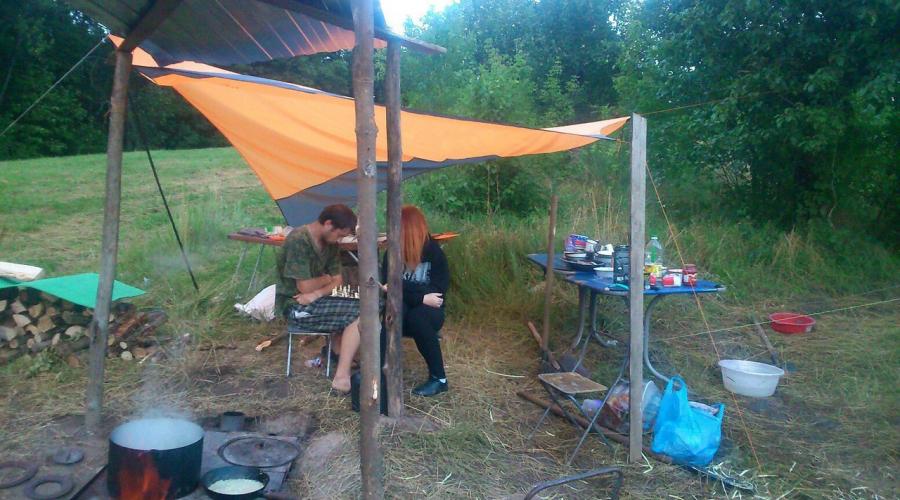
We traveled in 2015 in the village of Borisovka, Belgorod region. There is a Borisov settlement (Scythian, about 2.5 T. from back), the size of approximately 200h300.
Borisov town found in 1948. Settlement of 5-4 centuries BC. There had three strengthening lines, which defended its inhabitants from Nomad Scythians.
The first day of practice is the most difficult. You need to put the tents, the kitchen, the "refrigerator", the host tents:


It's a kitchen. According to rumors, one student did not want whether to work out practice, or I did a bad thing, and her father welded us such a kitchen. Food meals were three - at 7.30, at 14.30, at 19.00. The duty officers (guy and the girl) remain all day in the camp. The diet is cereals, stew, pasta, tea, cookies, condensed milk. It is the harder to pull it out in the morning - on the street, raw and want to sleep.

This is a host. It stores dishes and products. The photo is not visible, but behind it - the "refrigerator".

"Refrigerator" is a pit a few meters deep, where perishable products are stored. By the way about temperatures - in the afternoon under the sun, it reached 35 degrees, lowered to 20-25 in the rain.

I do not know how this tent is called correctly. It weighs about 400 kg, a metal frame. We collected it for several hours of inexperience. It was planned that there would be a headquarters, but because of the heat, we used it to keep the tools, finds, entered it during the rain of the belongings.

Now about the excavations themselves. We started working at 8.00, finished at 14.00 (we dug in the forest, and the heat was not so scary). Every hour - a break for 10 minutes to relax, and one for 20 minutes - the "second breakfast" - a sandwich with mayonnaise and saury:

In the first days we dug and immediately learned all the subtleties. Excavations are carried out in accordance with the documentation, we were taught to use the level.

Squared 5x5 depth 20-25 cm (1 bayonet shovel). Then the layer is cleaned - a smooth neat slice is made, so that the "earth glitter". In a pile of land, finds are searched for:

It is mainly ceramics and bones. The first days delight indescribable, then already sick of this. But! All finds are folded and brought to the camp, where in the subsequent ished and sorted.


To the ground "glitter", cleaning is made by barefoot. On the second photo, due to the rain, the excavation poured (:. It is used mainly two shovels - bayonet (for coppe) and the Soviet sharp "bison (for stripping).

Sometimes stumbled on the foci. They dig a neat little shovel under the supervision of scientists. All layers are photographed and sketched, foci, too. Finds from the hearth - in a separate package.
The depth of our lamp was 50-90 cm, digging to the natural layer, i.e. Before clay in our case.
We were on the excavations for three weeks. One day off a week, Saturday was abbreviated. Regarding the San.Uzla - we were lucky, and our camp was located on the territory of the reserve administration - washbasins 200 m, shower, toilet. The second luck - before the excavation, we traveled on the cars through the village, on foot to the village - 20 minutes. Fresh chicken was for lunch, if the duty officer is not lazy. And in general, stocks can be easily fill.
"Subtleties":
1) at the end of the excavations, all the pits fall asleep the same land, as if we were not here
2) During the archaeological intelligence, I found ceramics of the 18th century, and the wagism cartridges. Where found - left there. These items will be their excavations.
At the end, the first yearrs are dedication. It keeps in the secret, but at his end I looked like this:


All the clothes had to throw out (yes, right up to panties), and in the waters nearby all half an hour was laundered.
Is it worth going to the expedition - to solve everyone. If you are ready to be without communication, amenities, to see the same faces constantly (we were 12 students all) ... and however, decide for yourself.
But I am glad that I have such an eye shoulder)
Thanks to all!
It is necessary to make an opening of the Earth because the land is growing, hiding artifacts. The main causes of this increasing are:
- accumulation of garbage as a result of human activity;
- transfer of soil particles by wind;
- natural accumulation of organic substances in the soil (for example, as a result of rotting leaves);
- deposition of cosmic dust.
Permission to excavation
Excavations by their nature lead to the destruction of the cultural layer. In contrast to laboratory experiments, the process of excavation is unique. Therefore, in many states for the production of excavations, a special permission is required.
Excavations without permission in the Russian Federation are an administrative offense.
The purpose of the excavation
The purpose of the excavation is to study the monument of archeology and the reconstruction of its role in the historical process. Preferably, the complete opening of the cultural layer on its entire depth, regardless of the interests of a particular archaeologist. However, the process of excavations is very laborious, so often the part of the monument is often opened; Many excavations last for years and decades.
Special view of the excavations are the so-called security excavationswhich in accordance with the requirements of the laws are carried out before the construction of buildings and structures, since otherwise the archaeological monuments on the construction site may be lost irretrievably.
Archaeological exploration
The study of the site of the excavation begins non-destructive methods, including the measurements, photographing and description.
Sometimes in the process of intelligence for measuring the thickness and directions of the cultural layer, as well as to search for an object known from written sources, "prodes" (shurfs) or trenches are made. These methods spoil the cultural layer and therefore their use is limited.
Excavation technology
To obtain a holistic picture of life in the settlement, it is preferable to open a large solid area at the same time. However, technical constraints (observation of the cuts of the layer, removal of the Earth) impose restrictions on the size of a split section, the so-called open.
The surface of the excavation is leveled with the division into squares (usually 2x2 meters). The autopsy is conducted by formation (usually 20 centimeters) and in the use of shovel and sometimes knives. If the layers are easily traced on the monument, the opening is carried out on the layers, and not by formation. Also in the excavations of buildings, archaeologists often find one of the walls and gradually cleaned the construction, following the line of the walls.
Mechanization is applied only to remove the soil that is not related to the cultural layer, as well as for large mounds. When detecting things, burials or their traces, knives, tweezers and tassels are used instead of shovel. To save finds from organic substances, conservation is used directly in the excavation, usually with the help of filled with plaster or paraffin. The voids remaining in the ground from completely collapsed objects are poured by plaster to get the cast of the disappeared thing.
The study of the distant past is necessarily accompanied by a thorough photographic fixation of all stages of clearing archaeological residues. In the Russian Federation, the requirements for professional knowledge and skills of the researcher are strictly regulated by the "Regulations on the procedure for conducting archaeological field work and the preparation of scientific reporting documentation". The report must necessarily contain:
- full description of the studied monument of archaeological heritage and its topographic plan, made using geodesic instruments;
- data on the distribution of mass material at the opened platform with the application of statistical tables (lists) and patterns of things;
- detailed characteristics of the excavation technique, as well as each learned burial, all identified objects (TRISS, satellites, kerenotaphs, bedding, submits, fire, and so on) indicating the size, depths, shapes, structural parts and elements, orientation, level marks;
- information on special analyzes made with the involvement of anthropologists, biologists, geologists, and so on;
- sections of pits and other recesses with the designation of the features of their filling;
- stratigraphic rod and wall profiles;
The most important importance is attached to the quality of the accompanying drawings, which have recently become increasingly being created using modern computer technologies. It should be indicated on the need and planning observations.
see also
Write a review about the "Excavation" article
Notes
Sources
Literature from the historical encyclopedia:
- Blavatsky V.D., Antique Field Archeology, M., 1967
- Avedusin D. A., Archaeological exploration and excavations M., 1959
- Spitsyna A. A., Archaeological Excavation, SPb, 1910
- Crawford O. G. S., Archaeology In The Field, L., (1953)
- Leroi Gourhan A., Les Fouilles Préhistoriques (Technique et méthodes), P., 1950
- Woolley C. L., Digging Up The Past, (2 ED), L., (1954)
- Wheeler R. E. M., Archaeology from The Earth, (HarmondSworth, 1956).
Links
- // Jewish encyclopedia of Brockhaus and Efron. - St. Petersburg. , 1908-1913.
Excavation excerpt
- Clear, guys! - He sentenced him and picked up the guns behind the wheels and dismissed the screws.In the smoke, stunning with continuous shots, forced him to shudder every time, Tushin, not releaseing his noodles, ran from one to the gun to another, then aiming, then considering the charges, then there is a change in the variance and rigging killed and wounded horses, and smoked his weak thin horses, and smoked indecisive voice. His face was more and more enlivened. Only when they were killed or wounded people, he wrinkled and, turning away from the dead, he shouted angrily on people, as always, pouching to raise the wounded or body. Soldiers, the biggest part of beautiful well done (as always in the battery company, two heads above their officer and twice the wider than him), everything as children in a difficult position, looked at their commander, and the expression that was on his face, invariably reflected on their faces.
As a result of this terrible buzz, noise, the needs of the attention and activities of Tushin did not experience the slightest feeling of fear, and the idea that he could kill or hurt him, did not come to his head. On the contrary, he became more fun and more fun. It seemed to him that for a very long time, hardly yesterday, was that minute when he saw the enemy and made the first shot, and that the block of the field on which he was standing was to him a long time known, a relative place. Despite the fact that he remembered everything, everything consumed, everything was done that he could do the best officer in his position, he was in a state, like a feverish nonsense or the condition of a drunk man.
Because of stunning from all sides of the sounds of their guns, because of the whistles and blows of the shells of enemies, because of the type of sweaty, painted, rushing around the guns of the servants, because of the type of blood of people and horses, because of the appearance of the enemy's smoke on that side (after which everyone Once the kernel flew and beat into the ground, in a man, in a gun or a horse), because of the species of these items, he installed his fantastic world in his head, which was enjoyed at this moment. The enemy cannons in his imagination were not guns, but tubes, of which rare clubs produced the smoke invisible smoker.
"You are hanging," I said again, "Tuchet said to myself, while the smoke club and left the cluster came from the mountain," now the ball is waiting for the ball back.
- What do you need, your wellness? - asked Fairverker, who was close to him and heard that he muttered something.
"Nothing, grenade ..." he answered.
"Well, our Matvrevna," he spoke about himself. Matvnoy appeared in his imagination is a big extreme, ancient casting cannon. Ants were presented to him by the French near their guns. Handsome and drunkard The first number of the second tool in his world was uncle; Tushin more often looked at him and rejoiced to every movement. The sound then I am survived, then again an ingraded rifle shootout under the pea was represented by him whose breathing. He listened to the quiet and the warmly of these sounds.
"Iha, I breathed again, I slept," he said to himself.
He himself seemed to himself a huge growth, a powerful man who ends with both hands by the French kernel.
- Well, Matvrevna, Mother, do not give out! - he said, moving away from the gun, as an alien, unfamiliar voice rang over his head:
- Captain Tushin! Captain!
Tushin frightened frightened. It was the headquarters officer who drove him out of the soil. He shouted his breathing voice:
- What you crazy. You ordered twice twice, and you ...
"Well, why are they me? ..." thought Tushin to himself, looking at the boss with fear.
"I ... Nothing ..." he said, admiring two fingers to the visor. - I…
But the colonel did not negotiate everything that he wanted. Closely flying the kernel made him, diving, bend to the horse. He fell silent and just wanted to say something else, as the kernel stopped him. He drove the horse and crushed away.
- to retreat! All to retreat! - He shouted from afar. The soldiers laughed. After a minute an adjutant with the same order arrived.
It was Prince Andrei. The first thing he saw, leaving the space, which was occupied by Tushina's guns, was a dressed horse with a broken foot, which rusted near the harnessed horses. From her legs, both from the key flowed blood. Between the forefront lay a few killed. One kernel after another fluttered over him, while he drove, and he felt the nervic trembling ran through his back. But one thought that he was afraid, raised him again. "I can't be afraid," he thought and slowly tears from the horse between the guns. He gave orders and did not leave the battery. He decided that with him remove the guns from the position and would take them. Together with the carcass, walking through the bodies and under the scary fire of the French, he took up the cleaning of guns.
- And now the bosses come now, it's more about Droool, "said Andrei Fairverker, - not like your wellness.
Prince Andrei did not say anything with a carcass. They both were and are so busy, which seemed to have not seen each other. When, putting out of four two tools in front of the front, they moved under the mountain (one broken gun and unicorn were left), Prince Andrei drove up to Tushina.
"Well, goodbye," said Prince Andrei, holding out the hand of Tushina.
- Goodbye, darling, - Tisin said, - a cute soul! Farewell, dove, "said Tushin with tears, which unknown why suddenly spoke to his eyes.
Wind verse, black clouds hung over the battle seat, merging on the horizon with a powder smoke. It became dark, and the more clearly designated in two places of glow fires. Cannonade has become weaker, but the crackles of the guns behind and right was heard more often and closer. As soon as Tushin with his tools, circling and driving on the wounded, left under the fire and descended into the ravine, he met the bosses and adjutants, including the headquarters of the officer and the jersee, twice sent and never bought Tushina's battery. All of them, interrupting each other, gave and transferred orders, like where to go, and made him reproaches and comments. Tushin did not dispose of anything and silently, fearing to speak, because with every word he was ready, he himself was not knowing why, to cry, drove behind his artillery klyach. Although the wounded ordered was to throw, a lot of them dragged for the troops and asked to the gun. That the most imminent infantry officer, who in front of the battle jumped out of the Tushina chala, was, with a stomach bullet, put on Matvoren boots. Under the mountain, a pale hussar junker, his one hand keeping the other, went to the carcass and asked to sit down.
Archaeological excavations require the achievement of an optimal balance between two, often polar circumstances, - say, a necessity, on the one hand, to destroy some structures, and on the other - to get the maximum number of information about the past, or achieve the necessary funds for excavations or satisfy the momentum requirements societies. If the excavations are carried out, their final goal is to obtain a three-dimensional document (Record) about the archaeological monument, which will record various artifacts, buildings and other finds, correctly placed by their origin and context in time and space. And after this stage is completed, the document must be fully published in order to save information for descendants.
Solid and selective excavations
The advantage of continuous excavations of the monument is that they give detailed information, but they are expensive, and they are undesirable due to the fact that after them cannot be carried out by subsequent excavations, possibly more advanced methods. Usually, solid excavations are carried out within the framework of such Ukr projects, in which the monuments threaten the inevitable destruction.
The most typical are selective excavations, especially in cases where time plays an important role. Many monuments are so great that the solid excavations are simply impossible, and the studies are conducted selectively, using sampling methods or with the help of carefully verified tranches. Selective excavations are carried out to obtain stratigraphic and chronological information, as well as to obtain samples of ceramics, stone instruments and animal bones. Based on these evidence, the archaeologist may decide on the feasibility of subsequent excavations.
Vertical and horizontal excavations
Vertical excavations Always selective. During their holding, limited monument areas are revealed in order to obtain specific information. Most vertical excavations are the testing of deep archaeological layers, their real purpose is to obtain a chronological sequence on the monument. Horizontal excavations are carried out to disclose the simultaneous settlement in a large area. However, it should be emphasized that all strategies of excavations are based on decisions taken as excavations and research project. Anyway, the examples given here and in other texts show already completed excavations. During the excavations, the archaeologist may well move from vertical excavations to horizontal, and vice versa, even during short-term work.
Vertical excavations. Almost always, vertical excavations are carried out to establish stratigraphic sequences, especially on such monuments, the territory of which is limited, for example, in small caves and rock shelters, or to solve chronological issues, such as sequences along trenches and earth structures (Fig. 9.4). Some vertical trenches achieve impressive sizes, especially breakaged on residential hills. However, in most cases such excavations are not large-scale.
Shurfi.which is sometimes called the French word Sondages or telephone booths often have the type of vertical excavations. They consist of small trenches, which can fit one or two squams, and are intended for penetration into the lower layers of the monument to establish the limits of archaeological layers (Fig. 9.5). The shurtes are digging to extract the samples of artifacts from the lower layers. This method can be improved by drills.

The shurts predict large excavations, since the information obtained with their help is at best of the limited. Some archaeologists make them only outside the territory of the main monument, as they destroy important layers. But rationally placed shurts can give valuable information about stratigraphy and the contents of the monument before the main excavations begin. They are also roasted to obtain samples from different sections of the monument, such as the deposits of the shell, where the concentration of the artifacts found in the layers of artifacts is high. In such cases, the shurfs are rotated on the grid, and their position is determined by the statistical sample or on the basis of the right structures, such as alternating squares. Especially effective series of shurts, dug around both on a chessboard, during excavations of earthy fortifications, as the shurph walls separated by non-colored blocks provide a continuous stratigraphic sequence through all the strengthening.
Vertical trenches were widely used in excavations of ancient monuments - settlements in the south-west of Asia (Moore - Moore, 2000). They can also be used to obtain a cross-section of the monument, which threatens the destruction, or for inspecting the dyed structures near the village or the cemeteries, on which large excavations were carried out. When creating such vertical excavations, it is almost always awaited that as a result of this, the most important information will be in the form of fixing the layers in the walls of trenches and finds in them. It is clear that the information obtained with such excavations has limited value compared to larger surveys.
Horizontal (zone) excavation. Horizontal, or zone, excavations are conducted more largely than vertical, and are the next step to solid excavations. Under the zero excavations, it is referred to in the coverage of large zones to restore construction plans or plans for a whole settlement, even historical gardens (Fig. 9.6, see also a photo at the beginning of the chapter). The only monuments that are inevitably digging completely, are very small parking hunters, detached huts and mounds.

A good example of horizontal excavations is a monument to Saint-Augustine, in Florida (Digan - Deagan, 1983; Milanich and Milbrat - Milanich and Milbrarth, 1989). Saint-Augustine was founded on the Eastern Coast of Florida by Spanish Conquistor Pedro Member Devil in 1565. In the XVI century, the city was flooded, fires, hurricanes were hit, and in 1586 he loosened Sir Francis Drake. He destroyed the fortress city, the appointment of which was the defense of the Spanish fleet, which was transporting treasures on Florida Straits. In 1702, the British attacked Saint Augustine. Residents of the city were hidden in the fortress of San Marcos, which remained so far. After six weeks of siege, the British retreated, the dodged burning wooden buildings. In their place, the settlers built stone buildings, and the city continued to grow to the first half of the XVIII century.
Kathleen Diol, along with a group of archaeologists, explored the city of the XVIII century and its earlier part, combining the preservation of the city with archaeological excavations. Excavations of the city of the XVIII century are difficult for many reasons. Partly due to the fact that the three-time archaeological layer is only 0.9 meters and is largely broken. Otters cleared and fixed dozens of wells. They also produced horizontal excavations and revealed the bases of the buildings of the XVIII century, built of earthy concrete, cement-like substance from oyster shells, lime and sand. Foundations from oyster shells or earth concrete laid on trenches in the form of a building under construction (Fig. 9.7), then the walls were erected. The floors from the earth concrete quickly destroyed, so the new floor was created on Earth. Since the layers around the house were violated, the artifacts from the foundation and floors were very important, and selective horizontal excavations were the best method in order to reveal them.

The problems of horizontal excavations are the same as for any excavations: stratigraphic control and thorough measurements. With such zone excavations, large open areas of soils are exposed to the depth of several tens of centimeters. A complex wall of walls or pillars can lie within the survey zone. Each sign correlates with other structures. This ratio should be clearly fixed for the correct interpretation of the monument, especially when it comes to several periods of settlement. If a whole plot is disclosed, it is difficult to measure the position of the structures in the middle of the trench, far from the walls of the edge of the excavation. More accurate measurements and fixation can be achieved by using the system, which gives a network of vertical stratigraphic walls across the zone roll. Such work is often performed by laying the mesh of square or rectangular units of excavations with the walls between squares with a thickness of several tens of centimeters (Fig. 9.8). Such split units may be 3.6 square meters. meter or more. Figure 9.8 shows that this system allows for stratigraphic control of large areas.

Large-scale excavations on grids are extremely expensive, require a lot of time, besides, they are difficult to spend on uneven places. Nevertheless, many monuments "Netting Excavations" were successful: buildings were revealed, cities and fortification plans. Many zone excavations are "open", during their holding large sections of the monument are exposed by a layer of layer without a grid (see Fig. 9.1). Electronic examination methods solved many problems of fixing with large horizontal excavations, but the need for a clear stratigraphic control remains.
Removing the overlying layers that do not have archaeological significance in order to reveal subsurface details - this is another type of large-scale excavation. Such a removal is especially useful when the monument is buried in shallow under the surface and traces of buildings are preserved in the form of columns and changes in the soil color. Almost always, the arcs enjoy exercise equipment to withdraw large sections of surface soils, especially in UKR projects. With such a work, both qualified driver drivers and a clear understanding of stratigraphy and soil textures are required (Fig. 9.9).

Russian archaeologist, publicist and writer. 1899. Born is the largest specialist in Scythian-Sarmatian archeology, classical philology and antique ceramic epigraphy, doctor of historical sciences, professor. 1937 Born Igor Ivanovich Kirillov - Doctor of Historical Sciences, Professor, Specialist in the Archeology of Transbaikalia. 1947 Born Davron Abdulloev - Specialist in the archeology of medieval Central Asia and the Middle East. 1949 Born Sergey Anatolyevich Right - Archaeologist, Doctor of Historical Sciences, Professor, Specialist in the early Iron Venus of the Northern Black Sea region. Known as well as a poet. Days of death 1874. Died Johann Georg Ramzauer - Officer from Halstopa mine. It is known for discovered in 1846 and led there the first excavations of the burials of the Galstatt culture of the Iron Age.
The question of the need for excavations, their area and place is solved on the basis of intelligence data, depending on the specific needs of the restoration and the degree of preservation of the monument. There are three types of autopsy - trenches, shurtens and sweeps (Fig. 41, 42, 43).
41. Peter Metropolitan Cathedral of the High-Petrovsky Monastery. The results of the excavations in the interior. Removed layering of the late XVII - XVIII centuries. In the altar and central parts, initial floors, altar structures, constructed pilasters, and the like are open.
1 - modern concrete floor;
2 - Running under the floors of the XVIII - XixVV.;
3 - wood pulp of floor of the end of the XVII (?) B.;
4 - recessing under a delaim;
5 - Lime spilling under the brick floor XVI (?) - XVIIIV.;
6 - the remnants of the layout of the brick floor;
7 - the basis of the altar barrier of the XVI-XVII centuries;
8 - brick floors of the XVI-XVII century altar.;
9 - the foundations of the thrones of the XVI-XVII centuries;
10- service altar niches;
11 - the base of the altar;
12- The foundation of the altar barrier;
13 - Sand outlet (mainland), subfolding under the field of the XVI century;;
14 - layer of the monastery of the XIV-XVI centuries. with traces of ancient wooden temple;
15 - plate-tombstones at the XV Cemetery level.;
16- preserved parts of the pilaster;
17- General Plan of the Temple with an indication of an excavated part
42. Studies of the remnants of the unrevernant Wall of the courtyard sovereign in Kolomensky with the help of Shurfs and Tranche
Trench A - an example of a slit of the fallen wall in order to restore the initial height and decor of the facade with the preserved base unit;
Trench B - Example of tracking the track of the wall on the RB from the disassembled foundation;
Trench B is an example of determining the moment of termination of construction by stratigraphy.
The complete absence of building residues on the day surface of the foundation laying and above proves that the brick part of the wall was not erected
1 - white foundation;
2 - brick wall laying;
3 - the front part of the collapsed masonry in the profile;
4 - construction trash in the RB from the disassembled foundation;
5 - DERN XVIII-XX centuries.;.
6 - a cultural layer after disassembling the wall (XIX-XX centuries);
7 - Cultural Layer of the late XVII century. (after the construction of the wall);
8 - a layer of wall construction;
9 - mainland
43. The altar apse of the Northern Gathering of the Church of Mikhail Arkhangel in Smolensk is opened by excavations. Example of careful excavation
Trench as an intelligence tool is indispensable in the study of ensembles with a slight layer power. It is used to search for lost structures or their parts, to establish the relationship of individual buildings and sections. Through trenches, the tasks of studying the relief and organization of the area of \u200b\u200bthe ensemble in antiquity are solved. In the case of the detection of an ancient structure, it is necessary to deploy a portion of the trench in the excavation, sufficiently size for its full study. The construction in no way should collapse in order to deepen or continue the trench. On the monuments of multi-layered, with a powerful cultural layer (from 1 m or more) trenches are harmful because numerous objects hurt and cut them through, not allowing to fully explore or at least understand what it is. Trenches along the perimeter of walls, from the point of view of archeology, undesirable.
Trenches are often laid on the territory of restored objects during the device. They should be used for archaeological intelligence, as it is still impossible to abandon the laying. The autopsy of the cultural layer of trenches is carried out manually to the mainland on a width of no less adopted in archeology (1.5-2 m). Only upon completion of the archaeological study in the communication zone can be allowed to work mechanisms. This order should not be replaced by a simple archaeological supervision, except when the cultural layer and the territory plan is well known and the detection of antiquities is unlikely.
The concept of a shurf in archeology is sufficiently strictly and applies not to any hole of an arbitrary shape and a profile dug on the monument. Under the shurf is understood as a small rectangular excavator ranging from 1x1 to 4x4 m. Smaller shurts can not be laid on the monuments, even with a very thin cultural layer, at large sizes, the shurt is almost always considered as an excavation. On architectural monuments isolated from each other, Shurfs are permissible to solve engineering and technical tasks. Schurfs should not be unnecessary than numerous, as they give extremely fragmentary information, do not allow to figure out the plan of structures met in the land and even in stratigraphy.
The main means of archaeological research of the monument to the wide area is the excavation, i.e. The rectangular area of \u200b\u200bthe surface, layerly excavated to the mainland (untouched by human activity of the soil). The usual area of \u200b\u200bthe excavation is from 100 to 400 m2. The absolute size depends on the tasks of the study and power of the cultural layer. Exposures should allow as fully examined as possible a restored monument or an ensemble, having rouncing individual sections of its territory one with another and receiving not only a common stratigraphic picture, but also a detailed idea of \u200b\u200bthe plans for the disappeared buildings or parts of the building. Lost parts, the more so far structures, can be explored only by the wide area, i.e. excavation. The spreading is required for large earthworks (vertical layout) or when removing the soil from the inside of the monument.
Trenches and excavations need to be placed so that they adjoin the building wall with their narrow side - this is the only way to connect the layers of the structure with the surrounding thickness of the cultural layer. The tagging of the buildings only around the perimeter or dummy near them, not connected with each other, the shurts hopelessly bursts the structures from the cultural layer, harms not only this layer as a historical source, but also the architectural monuments themselves, destroyed the information stored in the layer.
Excavations lead manually by the layered-pivoting method adopted in archeology, with a mandatory bulkhead or sifting of the Earth and sweeping for each lifting "pin". Finds of each layer are selected, are described, sketched and stored in layers and squares (or shurps, sites, premises, etc.). Each find must be accurately fixed in its place in vertical and horizontal planes, and the countdown of depths, as in general on the excavations, lead from a single reference. All finds are collected, including mass ceramic and building material, and not just the "most interesting" - individual and architectural. (Nakhodka - state ownership and should enter the museum after processing.) It is necessary to closely monitor the structure of the opened layer - color, consistency, the amount of sand, clay and humus, the inclusions of the construction residues (chip, wood, stone, brick, lime, solution), Traces of burning (coal, ash, burned soil), etc.
The accuracy and completeness of stratigraphic information are largely dependent on the care of breaking and stripping excavations. They must be melted and tied on the ground with a high degree of accuracy, have straight corners and parallel direct sides. The walls of the excavations should be perfectly vertical and carefully protected to fix. The layer scheme is driven right on stripping, and then the formed lines are transferred to the drawing. Similarly - for layered plans: a thorough horizontal stripper allows you to read the outlines in the Earth, the spots of emissions, edges of the RVs. An important requirement of the technique is the study of all the reversible layers of the cultural layer, and not only related to the history of the studied monument. It should be remembered that even a very late monument can be located above the archaeological object: the pagan burial ground, the parking of the stone century, etc. The spreading should be brought to the mainland, even if the architect directly interesting layers remained higher. The exceptions are excavating monuments in cities with a multi-meter cultural layer, where from the base of the foundation to the mainland can be a gap in the meter and more. Lowering the excavation to such a depth is dangerous for the preservation of the building.
The study of the upper, the latest layers is also important. They carry information about the life of the studied monument to the new and the newest time, up to modern times. Material XVIII - XIX centuries. Causes the growing interest of historians - ethnographers, art historians, musevodov. The first attempts to create a single archaeological and ethnographic scale are made. Restaurant researchers working with a late layer in developing cities are a unique opportunity to enrich these science with new information. Historians know much better than the antiquity of the stone, bronze and iron centuries than the things of the late Middle Ages (the XIV-XVII centuries), which are not enough in museums and to which until recently during the excavations did not pay due attention.
One of the basic rules of the field methodology is to carry out all archaeological work only in the presence, with the participation and under the guidance of the owner of the open sheet (the lead researcher). It is strictly forbidden to reflect the oversight of the work of the prohibits, working and restorers, etc. In no case cannot be limited to preliminary instructions working and subsequent fixation. It should be constantly and carefully to manage the course of work, while at the same time carrying out the comprehensive fixation of its observations and conclusions. Information is not contained in the monument in the finished form, it only arises into the brain of the researcher as a result of understanding observations and is fixed by the researcher himself. Therefore, in no case, in no case should not be in a hurry, the layer should be removed methodically, so that there is a time for fixing opening situations.
To understand the history of the building, it is necessary to understand the order of layers as the monument itself and the cultural layer, to understand their sequence, correlation, mutual dependence, i.e. Understand stratigraphy. You can usually trace up to five most typical main layers. The first bottoms are the layers of building construction, which are characterized by abundant emissions of the mainland or more ancient layer from the foundation pvs, aligning flooring for floors, spray clay, solution, lime, layers of bricks, stones, chips and related elements of the construction site (lime pits , worked, sometimes kidding ovens, various kinds of workshops). The level of this construction overlaps the upper edge of the foundation, sometimes it turns out to be closed and part of the base. At this level, it should be tried to find out the design of the initial porches and external stairs (very often rebuilt parts of the building) and early planning of the surrounding area. It is necessary to remember that the marks of the oldest floor and day surface 1) behind the walls of the building coincide not always. Finds in the construction layer usually not older than the construction itself; Thus, the dates of finds and buildings are mutually checked or defined.
Above the level of construction of the building and over the floor there are layers of adherence, usually humus, relatively horizontal. They may include a number of new floors, on top of the initial, with prisoners between them garbage and under-raws, and outside - layers of small repairs, messy, porch, paths, drainters, etc. At this stage, violations of the initial building layers begins, since they were fish, due to the operation of the building and the territory. The slaughtering layers include layers of capital repairs, partial destruction, redevelopment, rearrangements, etc., sometimes significantly distorted the appearance of the initial construction. They combine the remains of ancient building materials from disassembly and new used during reconstruction.
The next reservoir is associated with the final destruction of the building or its part and is usually formed by the mass of the rolled. These are piles of fragments from the failed roof, fallen blocks of wall masonry and arches, sometimes with ash and coal, indicating in this case for the cause of destruction. Such layers go into obliquely down from the surviving parts of the walls and reliably overlap the top (i.e. the last) residential layer, so on the content it is easy to install the date of destruction.
The fourth reservoir form, in essence, the same ruins, but gradually smoothed under the influence of atmospheric phenomena. The deepening between loosely lying fragments are gradually tightened, overgrowed with turf. Under the layer of collapse, thin ribbons of nodules and baths are formed, including minor construction residues. This layer can have places to have lenses deposited with the periodic use of the preserved parts of the ruined building as shelter, temporary housing. The last layer is traces of disassembly ruins for the production of building materials, cleaning the area for new construction, etc. Usually it is easy to trace trenches or pits from the sample of stone, the moves of the treasures, traces of the works of archaeologists of the XVIII - XIX centuries., If they were. This will also include the results of modern work.
Of course, this scheme of stratigraphy is too common to be used on any monument in an inheumatic form. In order to close to the specific stratigraphy of the site and be able to present the life of the monument for a certain period, the concept of construction tier (or horizon) is used in archeology, which describes the complex at the same time existing structures (at least with different date of occurrence). Inside the tier, construction periods are distinguished, each of which is associated with a certain, concrete ancient construction activity on the monument, and therefore each of them has its own day surface. The establishment of these surfaces, their relative and absolute dating is the core of any archaeological study of the architectural monument. For example, the first construction
the reservoir should be necessarily divided into two levels - prior to the start of construction and by the time of the "commissioning" of the finished building. Often they differ significantly from each other (and from different sides of the building there is a different picture). There are artificial subfins that align the soil or changing relief, sometimes quite powerful, but there are also cases of the cutting of the soil before starting work. Usually, the difference between the two surfaces determines the amount of emission from the RVA (well-readable thanks to the whole color of the mainland, if it has been done to it) and garbage from construction work.
Of course, the story, and the type of site before the construction of a restored building are not indifferent for the architectural archaeologist. What was it here? Waste or hidden place? How was it used? Is life changed here with the construction of a studied building? Is it preceded by a similar function and what happened to him?
In the second and third formations that characterize the time of the building and therefore, it is usually more powerful than the first formation, the number of intermediate day surfaces increases sharply, especially since the repair and construction periods have to identify and "non-construction" levels that fix those or other historical moments in life settlements (for example, large fires). Having allocating all intermediate daytime surfaces and placing them between construction periods within one of the tiers, the researcher receives relative dating, i.e. Learn what kind of repair has occurred before, and what after a fire, as separate extensions and the like correspond to each other in time. To obtain absolute dates for surfaces, it is best to link at least a few layers with writing data. Especially important for this layer of coal and ash, labeling the level of large fires marked in the chronicles or ice documents.
It is extremely important to create a solid chronostratigraphic lattice of construction tiers of the entire complex, since in this case the absolute dates associated with specific buildings or layers make it possible to calculate the rest with some accommodation. This method of cross-stratigraphy is applicable on one building for correlation in time of different parts. The fourth and fifth layers are stratigraphically much easier, the main thing in them is the contents of the rusticity itself, since it is here that in the boosts of construction waste, it is often all necessary to restore the design and decor of the building. Disassembly of the dawns should be considered as a special case of archaeological research and leading to all possible attention, sorting the following materials (threaded blocks, profiled blocks, lectal brick, brick with terminals, brick from facades of masonry and from its inner part, brick without traces of a solution used For paving, chimney brick, tiles, floor tiles, tile, etc.) in order to produce after measurements, counting, sketches, selection of collectible instances.
The scheme scheduled for the stratigraphy of the layer in practice is read by the researcher just the opposite, because the excavations are conducted from above: from the layers of late, layers of destruction and disassembly, the ancient construction. Therefore, when excavations, it is necessary to constantly remember the stratigraphic tasks and collect material for their solution, studying in detail and fixing the removable layers. The material then can be adjusted by the removal profiles.
Unfortunately, the picture of stratigraphy is almost never simple and clear, as in the scheme. The urban layer (near the ancient buildings in particular) was repeatedly drunk. The most frequent cases of perekopov are various economic and industrial pits (wells, cellars, basements, garbage points, worn, sumps), pitted and piva under the foundations of later buildings. For monastic and church complexes, grave pits, crypts, etc., strongly damaging layer are characteristic. The latest layer impairment is a pit that remained after the repair of foundations, restoration or research works of the XIX-XX centuries., Communication trenches, etc.
These damage is a uniformly laid-up layer lead not only to breaks in horizontal stratigraphy, but also to the penetration of late materials in the early layers and in the mainland. They also "take out" to the late day surfaces. Early things in the composition of the emissions from the holes. If these pits, voltages and emissions ignore, do not allocate, then all absolute dating, and stratigraphy as a whole hopelessly confused. The earlier the pits will be fully identified, the better. Sometimes the dark humus of the layer is inseparable in color from the filling of the pit, but usually the pit is distinguished by light mainland splashes or the "color" border, due to the ancient wood sheath or coating, roasting the walls, etc. A pit can almost always be found on a more loose filling and other composition of finds, especially building trash, kitchen residues and oven emissions. It is easy to determine the pit even in the most faded layer if it enters the profile, as well as when cutting it by the construction horizontal layer. Then the pit is chosen, without damaging the surrounding layer, fix its profile, shape, sizes, filling, made finds. It is very important to set the level from which the pit is dug, and the fill period. The more often the hops, the more holes (when they repeatedly break each other, it is very difficult to unravel them), the more difficult the task of the researcher. There are cases of complete destruction of stratigraphy of the site, then you have to look for another, better preserved place; As a rule, it is located. If the cultural layer is overly spoiled, the ancient layers makes sense to look inside the construction or under the ruins of its not surviving parts. Usually they persist near the moulders, gatherings, doors of buildings and under the tracks, if their direction has not changed for a long time.
1) the day surface in archeology is called the level formed during a certain period as a result of long-term adherence.
How are archaeological excavations?
It means how to raise the whole crowd of the Earth, which for centuries and millennia was applied by the winds, water flows, layered by the remnants of rotting plants, lift so as not to disturb everything that was left, lost or thrown into the long time. A layer of land over the remnants of abandoned settlements and other traces of human life grows and now, annually and daily. According to experts, it is currently rising annually into the air, and then deposits 5 million cubic kilometers of rocks. Water blur and transfer even more soil from place to place.
"Archeology is a science of shovels," the old textbooks say. This is not exactly accurate. It is necessary to dig up not only a shovel, but also a knife, a medical scalpel and even a watercolor tassel. Before starting the excavation, the surface of the monument is broken with pegs on equal squares with an area of \u200b\u200b1 (1x 1) or 4 (2 x 2) m2. Each peg is numbered and applied to the plan. All this is called a grid. The grid helps fix finds on the plans and drawings. When excavations, all work is carried out manually. It is still impossible to mechanize this difficult, subtle and responsible business. Only removal of the Earth from the Rate is mechanized.
Multi-layered monuments are very often found - usually places in which people settled repeatedly. In Central Asia and in the Middle East, where globate houses were built from raw bricks, layering on each other ruins of ancient cities formed hills a few tens of meters - Telly. It is difficult to understand this laminated monument. But it is even harder to bundle those ancient settlements, where the houses were built from wood. From such settlements, only a thin layer of rotten residues, ashs, coals and not fully rotated organic residues remain from such settlements. This dark color layer is well noticeable in the wall of the incistent ravine or in the edge of the blurred river bank. In archeology such a layer is called a cultural layer, since it remains the remnants of one or another ancient culture of man. The thickness of the cultural layer is different. In Moscow, during the construction of the subway, it was found that in the city center it comes to 8 m, and in the area of \u200b\u200bSokolnikov, only 10 cm. On average, 5 m in Moscow was deposited in Moscow. At the Roman Forum, the thickness of the cultural layer - 13 m, in Nichgure (Mesopotamia) -
20 m, in the settlement Anau (Central Asia) - 36 meters above Paleolithic parking in Africa - hundreds of meters of stone. At the Karatau parking lot in Tajikistan over the cultural layer of 60 m clay.
Ancient people were digging dugouts, pits for storing products, deepening for fires, without worrying, of course, about preservation for archaeologists of the cultural layer. To better understand the stratigraphy (alternation of the layers) of the monument, between the squares, there are narrow strips of untouched areas - brings. After completing the excavations, you can see how one cultural layer is replaced by another. Running profiles are photographed and sketched. Between the brows, the Earth is simultaneously removed by the formation of no more than 20 cm over the entire area of \u200b\u200bthe excavation area.
The work of the archaeologist can be compared with the work of the surgeon. Little misses leads to the death of an ancient object. When excavations, it is necessary not only not to damage the finds, but also to put it, keep them from death, to describe everything in detail, take pictures, draw, draw up the plan of ancient structures, stratigraphic excavation profiles, to accurately note the sequence of alternation of layers. It is necessary to take on the analysis all sorts of materials and so on.