Features of the physical geography of Crimea. Geography of Crimea
Crimea today is the blessed land of the Crimean Peninsula, washed by the Black and Azov seas. In the north, he extends plain, in the south - Crimean mountains with a necklace at the coastal strip of seaside resort cities: Yalta, Mishor, Alusta, Simeiz, Gurzuf, Alushta, Feodosia, Evpatoria and seaports - Kerch, Sevastopol.
Crimea is located within 44 0 23 "(Cape Sarych) and 46 0 15" (Perekopsky) of northern latitude and 32 0 30 "(Cape Karamrun) and 36 0 40" (Cape Lantern) Eastern longitude. The Square of the Crimean Peninsula is 26.0 thousand km 2, the maximum distance from north to south is 205 km, from west to east - 325 km. The narrow eight-kilometer strip of sushi in the north (Perekopstye) connects the Crimea with the mainland, and 4-5 km - the width of the Kerch Strait in the East (the length of the strait of about 41 km) is separated from the Taman Peninsula. The total length of the borders of the Crimea exceeds 2500 km (taking into account the extreme toasting coastline of the North-East). The Black Sea forms three large bays: Carcinite, Kalaytsky and Feodosia; The Azov Sea is also formed three bays: Kazantipsky, Arbat and Sivash.
Physico-geographical position
The physico-geographical position of Crimea In general, it is distinguished by the following most characteristic features. First, finding the peninsula 45 0 of the northern latitude causes its equidistant from the equator and the North Pole, which is associated with a sufficiently large number of incoming solar energy and a large number of solar shine hours. Secondly, Crimea is almost an island. This is connected, on the one hand, a large number of endem (plant species, which have not found anywhere, except for this area) and endemics (similar species of animals); On the other hand, this explains the significant depletion of the Crimean fauna; In addition, the climate and other natural components have a significant impact of the marine environment. Thirdly, the position of the peninsula relative to the overall circulation of the Earth's atmosphere, leading to the predominance of Western winds in the Crimea, is particularly important. Crimea occupies a border position between moderate and subtropical geographical belts.
Climate
Climate most of the Crimea - This is a climate of a moderate belt: soft steppe - in the flat part; More weta, characteristic of deciduous forests - in the mountains. The south coast of the Crimea has a subsened-free climate of dry forests and shrub thickets.
The Crimean Peninsula is provided with plenty of heat not only in summer, but also in winter. In December and January, there are 8-10 times more, for example, in St. Petersburg in St. Petersburg for a day than, for example, in St. Petersburg.
The greatest amount of solar heat is the Crimea in the summer, especially in July. Spring here is cooler autumn. And autumn is the best season of the year. The weather quiet, solar and moderately warm. True, sharp fluctuations in pressure during the day sharply exacerbate cardiovascular diseases in people are not entirely healthy.
In the Crimea, well-provided heat, biological productivity of plants, including crops, stability of landscapes to loads largely depend on the amount of moisture. And the need for water is constantly increasing at the local population, and the national economy, primarily rural and resort. So water in the Crimea is a genuine engine of life and culture.
A relatively small amount of atmospheric precipitation, long dry summer, distribution in the mountains of the cruising rocks led the poverty of Crimea with surface waters. Crimea is divided into two parts: flat steppe with a very small number of surface watercourses and mountain forest with a relatively thick river network. There are no large fresh lakes. In the seaside strip of the plain Crimea there are about 50 limanov lakes with a total area of \u200b\u200b5.3 thousand km.
Crimean peninsula. Tourism
. In this article we will tell you about Crimeapeninsula. Despite the fact that in recent years, more and more tourists rushes to relax on the coast, as well as tropical islands Crimea Still, still remains a popular destination for hundreds of thousands of people. Foreign tourists, first of all attend the capital's city of Ukraine - Kiev, in which many historical and architectural attractions.
In addition, in the city of Kiev you can use the Internet directly in the parks of recreation. And if someone from tourists did not take his tablet computer on a trip, he can buy a laptop Kiev at an affordable price in numerous Foxmart stores in the city, which offer a wide range of laptops of various world-famous brands, such as: Samsung, Acer, Lenovo, ASUS, HP, Sony and some others. Thanks to the Internet and laptop, you can learn a lot of necessary, useful and, of course, interesting information, for example, about the Crimea Peninsula.
Geography of the Crimean Peninsula
. Extensive fertile resort Crimean peninsula Washed: in the West and South -, from the East - the Sea of \u200b\u200bAzov, including Sivash Bay. Crimean peninsula far deepened in the Black Sea.
Crimean peninsula Located in the southern part of the republic. Geographical Crimean peninsula Refers to the Northern Black Sea region.
On the territory of the Crimea Peninsula are the autonomous Republic of Crimea, the city of Sevastopol, as well as part of the Kherson region. Crimean peninsula In the documents of the Russian Empire, up to the 20s of the 20th century was called Tavrida.
After the creation of the Soviet Union, Tavrid's peninsula was renamed and called the name " Crimea" Toponym "Crimea" probably comes from the Turkic word "Kyrym", which literally means - shaft, wall, moat.
Square of the Crimean Peninsula
is approximately 26,860 km², of which 72% is a flat surface, 20% occupy Crimeamountains, 8% make up water objects - lakes, rivers.
The length of the coastline of the peninsula Crimea Make up over 1000 km.
The total length of the marine and land borders of the peninsula Crimea It is more than 2500 km.
The greatest length Crimeathe Peninsula in the direction of the West to the East between the picturesque Cara-Mrohana and the lantern is approximately 325 km, and in the direction from the north to south from the narrow Perekop Izka to Cara Sarych is 205 km.
Geography of the Crimea Peninsula
. On the Black Sea coast, there are the largest bays: Carcinite Bay, the Kamitsky Bay, the Feodosian bay. On the coast of the Azov Sea - the following bays: Sivash Bay, Kazantipian Bay and the Arabaty Bay.
In the east Crimeathe Peninsula between the Black Sea and the Azov Sea is the Kerch Peninsula, and in the West, a narrowing part Crimeaand forms a relatively small Tarkhankut peninsula.
In the northern part crimean peninsula The continent is connected by a rather narrow Perekopsty, whose width in the widest place does not exceed 8 km.
Relief of the Crimean Peninsula
. Picturesque crimean peninsula According to the nature of the relief, it is divided into platform-flat, which takes 70% of the entire territory, the rest falls on a folded mountain surface. On the southern peninsula Crimeadiscussed beautiful Crimeasky mountains.
The highest mountain of the peninsula Crimea - Mount Roman-Kos, which reaches a height of 1545 meters above sea level.
The extreme northern dot of the Crimean Peninsula is at the Perekopsty, his extreme southern point is a beautiful cape Sarych, an extreme western point is Cape Kara-Mrun (saber) on the Tarkhankutsky Peninsula, the extreme eastern point of the peninsula is Cape Lantern on the Kerch Peninsula.
it was formed as the Crimean region on June 30, 1945, the status of the republic was obtained in 1991. Its area is 26.1 thousand square meters. km (4.3% of Ukraine). The population is 2134.7 thousand people (4.3% of the population of Ukraine), including the urban population - 1338.3 thousand people (62.7%), rural - 796.4 thousand people (37.3% ). Population density - 81.8 people. on square. km.
Located in the Crimean Peninsula and is the most southernmost region of Ukraine. In the West and the south is washed by black, in the east - the Azov seas. Kerch Strait is separated from Russia. The length of the Autonomous Republic from north to south is 210 km, from west to east - about 325 km. Susche borders with the Kherson region. With the mainland, Crimea is connected by a narrow (8 km) of the Perekopsty, according to which the iron and highways pass. The second transportation from the territory of Crimea is an artificial embankment through Sivash. There is also a ferry crossing the "Caucasus" between the Kerch and the Taman Peninsula of Russia.
In administratively, the Republic includes 14 administrative districts, 16 cities, including 11 cities of regional subordination, 56 urban-type settlements, 957 rural settlements.
The administrative center is the city of Simferopol, the first mention dated XVI century, the city is since 1784. The population of the city has 338.9 thousand people.
The territory of the Crimea is characterized by significant natural diversity. The Crimean Mountains located in the southern part of the peninsula determine the separation of the territory to the North - flat (so-called. Steppe Crimea) and the South Mountain (Mountain Crimea). A narrow pebble strip of the southern bank of the Crimea extends along the southern foot of the Crimean Mountains. Minerals are represented by iron ores, natural gas fields on the shelf of azov, as well as deposits of building materials. In the area of \u200b\u200bthe Karadaga deposits of semi-precious stones. The South Coast of the Crimea is one of the most important resort areas of the CIS (climatotherapy, sea bathing from June to October, dirt, grape collecting).
The climate of the northern part is moderately continental, dry; South - subtropical Mediterranean type.
Rivers of the Crimea are small and low-water (r. Saligir, Belbek, Black, Kacha, etc.), on the largest of them created reservoirs that serve as sources of cities water supply. The largest water artery is the north-Crimean canal, the waters of which fields are irrigated. In Crimea, a large number of lifeline salted lakes (lake. Sasiek, Red, Sakskoe, etc.).
The Crimean Peninsula is ancient times of Slavic land (Slavs penetrate and settle here already in the VIII century). The most ancient inhabitants of the peninsula are the Kimmerians who basically lived in the Northern Black Sea region and settled in the Crimea. During the Middle Ages, part of the Crimean XII centuries.). The C-Peninsula was part of the Old Russian Tmutarakan Principality (x 1475 to 1774. It was a vassal of the Ottoman Empire.
In 1783, Crimea became part of Russia. In 1784, the Tauride region was formed, which included the Crimean Peninsula, Taman and the Earth north of the renovation to the Dnipropetrovsk governorship. After 12 years, its territory entered the Novorossiysk province. At the end of the XVIII century, Crimea began to intensively settle down from the central regions of Russia. October 18, 1921, the Crimean ASSR was formed. In 1944, Crimean Tatars and representatives of other non-Slavic peoples were evicted from Crimea. After the end of the war, the population resettlement began here with the territories of the USSR, which were especially injured. In June 1945, the Crimean ASSR was transformed into the Crimean region. In 1954, the Crimean region from the composition of the RSFSR was transferred to the Ukrainian SSR. In 1991, the Crimean region was transformed into the Republic of Crimea, which is part of Ukraine.
Crimea is a bright example of a complex multinational and multicultural social system. During the 1990s, in general, the Crimea records a stable tendency to reduce population population. The decline in the region's size is defined both by natural loss and migration outflow, and their ratio in Crimea is almost equal.
The age composition of the population of the republic is characterized by a higher share of people of working age compared to the Mid-Ukrainian indicators and a somewhat elevated specific weight of younger age groups.
Historically, the complex ethnic structure of the population has developed in Crimea. The Ukrainian regional community of Crimea is the most small in Ukraine. The largest share of the population of the Crimea is represented by the Russians (they accounted for more than 2/3 of the total population), while Ukrainians accounted for a little more than a quarter of its inhabitants. During the 1990s, some changes have planned in the ethnic structure of the population of Crimea. They are connected, firstly, with the migration influx of the Crimean Tatars and the outflow of representatives of other ethnic groups (primarily Russians) beyond the republic. The largest number of Crimean Tatars was recorded in the central and western regions of the republic, in some of them the share of Crimean Tatars is more than 25%.
Among religious organizations, communities of the Ukrainian Orthodox Church of the Moscow Patriarchate prevail, Muslim organizations have a rather noticeable influence.
The territory settled extremely unevenly. With an average population density of 81.8 people. on square. KM on the territory of the resort South Coast City Councils, he rises to 100 people. on square. km. For the Crimean Peninsula, a specific structure of the settlement is characteristic. Its base make up several basic elements. First, these are two major center of Simferopol and Sevastopol and, secondly, two "resort" group forms of resettlement are the South Coast and Saksco-Evpatoria. A relatively uniform and fairly extended homogeneous network of resettlement is observed in the steppe of the peninsula. In two centers of the settlement of the Crimea and about a third of the entire population of Crimea living towards them in total. Within the limits of the South Coast Lento-shaped group of city councils, a total of almost more than 17% of the total population of the republic is concentrated, or almost 15% of the total population of the peninsula, including Sevastopol. In the western resort area, which includes the cities of Saki and Evpatoria, as well as close settlements, the total number of cash is approximately 9% of the population of the republic.
The natural and climatic conditions of the peninsula identified the leading development of the sanatorium-resort economy, which has international significance. Specialization and other sectors of the service sector are largely related to this area of \u200b\u200bactivity. In the industrial complex of the industrial complex, the leading place is occupied by the food industry, oriented towards the processing of local raw materials. Among its branches of the general-Ukrainian value are played (Massandra), foonworking (Kerch, Yalta), canning (Simferopol), Etiroslenichny (Simferopol, Bakhchisarai, Alushta, Sudak) and tobacco-fermentation (Yalta, Simferopol, Feodosia). A chemical complex is functioning in Crimea, which is represented by the Simferopol Plastics Plastics, Saki Chemical Plant and others.
Agriculture is diversified. However, the leading role belongs to grain farm. Figure and technical cultures are cultivated on the irrigation lands. Gardening and viticulture, cultivation of ester and passenger crops developed.
Main attractions: State Architectural and Historic Reserve "Sudatsky Fortress" in Sudak, State Historical and Architectural Reserve in Bakhchisarai, Alupkin State Palace and Park Museum-Reserve.
The advantageous economic and geographical position of the Autonomous Republic of Crimea is due to the fact that autonomy occupies the territory of the Crimean Peninsula, located in the south of Eastern Europe between 46 ° 15'-44 ° 23 'Northern Latitude and 32 ° 29'-36 ° 39' East longitude. The Square of the Autonomous Republic of Crimea takes 26.1 thousand km2, which is 4.3% of the territory of Ukraine.
Crimea is located in a latitudinal belt of the globe, distinguished at equal distances from the equator and the North Pole.
In the north of the peninsula is connected to the mainland narrow (7-23 km) Perekopsty. From the West and the south of the peninsula washed the Black Sea, from the east - the Kerch Strait, and from the northeast - the water of the Azov Sea and its Bay of Sivas.
Black Sea - Extremely deep (up to 2245 m), almost closed, oval shape, reservoir. By area of \u200b\u200bits water surface (413488 km2), this flat-bottomed brand is more than 15 times superior to the Square of the Crimean Peninsula.
Azov Sea, on the contrary, very shallow way. It does not exceed the greatest depth of 13.5 m. It is much inferior to the Black Sea and in Square (37,600 km2).
From the north to the south of the peninsula stretched 180 km, and from the west to the east - 360 km. It borders with the Kherson and Zaporizhia regions of Ukraine, the Krasnodar Territory of the Russian Federation. Sea borders predominate in Crimea, the length of the coastline is about 1,500 km.
The richness of Crimea is his soft, close to the Mediterranean, climate for which the abundance of the sun, heat and light is characteristic.
The climate of the Crimea is determined by its geographical position, the relief and the influence of the washing peninsula of the seas. It is characterized by a large number of solar shine hours, but at the same time for most areas - lack of moisture. The abundance of sunny days (2180-2470 hours per year), warm sea, moderately humid air saturated with seafood, beautiful mineral springs, effective healing dirt - all makes an unforgettable stay on the peninsula. The climate of the northern plain part of the Crimea is moderately continental with a short minor winter and moderately hot dried summer.
By the amount of heat and moisture, the Crimea is among the relatively favorable areas for the development of agriculture. There is an active vegetation of wheat, corn, most fruit crops and grapes.
Crimea is rightly called natural pearls of Europe. Here, at the junction of moderate and subtropical latitudes, a wide variety of natural landscapes: mountains and plains, ancient volcanoes and modern mud hills, seas and lakes, forests and steppes, the nature of the Crimean subsensnifier and the semi-desert of the prier ...
It is no coincidence that this corner of the unique land has long been attracting the attention of people, and in recent decades has become a real "Mecca" for millions of resort workers and tourists.
From a bird's eye view, or when looking at a physical map of the Crimea, you can easily imagine the main features of the geography of the peninsula. As if the ancient Taurida's bone, she snapped in the south of the mountain Crimea. To the north of him, the plains extend, the Kerch Kholmogorie spread out in the east. The Crimean Mountains with a giant stone scarcker cut off the subsenedison-free South Coast of the Crimea, and north of them, the ribs of the coastal Girdo, stretches the forest-steppe foothills.
Crimean mountains with a sheer wall are broken in the direction of the sea coast, and opposite their slopes of the field. The highest peaks - Roman-Kos (1545 m), Ai-Petri (1232 m), Chatyr-Dag (1527 m), Northern Demerji (1356 m), sheer walls, from 200 to 400 meters high, stretch along the coast from Cape Ayia to the village of Gurzuf.
The territory of the republic employs 257 rivers more than 5 km long. The largest - salgir, a length of 220 km, and the most fulfillment - Belbek (water consumption of up to 150 liters per second).
On the peninsula, mainly along the coasts, there are more than 50 salty lakes used to obtain salts and therapeutic mud: Sakskoe, Sasiek, Donuzlav, Bakal, Old Lake, Red Lake, Aktash, Chokrakskoye, Uzunlar, and others.
In the Crimea, more and more travelers and tourists rushes every year: over the past 70 years, the flow of recreants has increased 100 times! Under these conditions, the Natural and Reserve Foundation of the Crimea is of particular value and scientific and environmental interest.
The share of the protected fund accounts for more than 135 thousand hectares of the territory of the peninsula, which is 5.2% of its area. The Reserved Fund plays a significant role in the preservation of the creations of inanimate and wildlife, stabilizes the ecological situation on the peninsula.
Crimea is a unique region of Ukraine, where 152 objects of the natural and protected fund are located on a relatively small area, including 6 natural reserves, 30 reserves, 69 monuments of nature, 2 botanical gardens, 1 Dendrological Park, 31 Park-and-Park Art Park Art Park , 8 reserved tracts, 1 zoo.
In Crimea, more than 200 mineral deposits are known. Iron ores (Kerch iron ore pool), Sivash salts and seaside lakes (old, red, etc.), Natural gas (Black Sea field), Flux Limestones (Balaclava, Kerch deposits, etc.), Cement Mergeli (Bakhchisarai), Pottery and bleaching clay (foothills). For therapeutic and recreational purposes, therapeutic dirt and mineral springs are used (Saki, Evpatoria, Feodosia, etc.), sandy and pebble beaches (Western and South Coast, Priazovye).
The climatic conditions of the Crimea are very diverse. Crimea is surrounded by a water pool, crossed mountain plateau, with gentle slopes to the north and sharp - to the south (to the Black Sea), which is protected from the influence of the northern winds. Mountains cut through valleys. At various heights above sea level, there are conditions that affect the nature of the climate.
Each slope of the Crimean Mountains has its climatic conditions, for it is subjected to a greater or lesser degree of influence of those or other dominant winds. The warmest part of the southern shore is the space from Cape Ayia to Cape Ai-Todor, as this part of the coast is like in the wind shadow from the cold northern and northeastern winds. The effect of eastern winds is already becoming a noticeable effect of Eastern winds and, thus, the second place on the warmth occupies part of the southern shore from Ai-Todor to Alushta, and the third place is warm - from Alushta to Koktebel, and the degree of gradual transition from the warm climate to more It seems to be in parallel with the gradual decrease in the heights of the mountains from Alushta to Feodosia. Feodosia is already open to the Northern and Northeast winds, and its climate, which has its local features, is closer to the climate of the Kerch Peninsula.
Warm air, coming to the Crimea from the south, penetrates relatively fluently through the low Crimean mountains into the steppe areas of the peninsula. Upon the invasion of cold dense arctic air, the mountains prevent its penetration on the skirt. In this regard, a very significant comparison of the average January air temperature in the central part of the plain Crimea (PGT. Krasnogvardeyskoye) and in Yalta - respectively -2 ° C and + 4 ° C. If there were no mountains in the Crimea, the south bank would have little difference from the steppe coast of the Black and Azov seas. At the same time, the role is not so much the height of the Crimean Mountains, how many of their general directions - from the west to the east, in parallel the coast.
Crimea refers to the number of the most sunny areas of the European part of the CIS. The annual duration of the solar shine here changes within 2180 - 2470 hours. It is especially great on the sea coast, where the Breeze prevents the formation of clouds. From the annual amount of radiation, the Crimea receives in the winter of about 10%, in the spring - 30%, in summer - 40% and in autumn - 20%. The largest amount of solar heat of the peninsula also receives in the summer. The minimum number falls on mountain areas, and the maximum - on the west coast. But be that as it may, in December and January, on the unit of the earth's surface per day, heat is 8 -10 times more than, for example, in St. Petersburg.
In winter, an axis of increased atmospheric pressure is often installed in the winter over the southern part of the European CIS territory in the latitudinal direction, and the reduced pressure zone above the Black Sea. As a result, cold and dry continental air of moderate latitudes or arctic air often invade the Crimea. With this, sharp decreases of temperature and strong northeastern winds are connected. In the same season, cyclones come from the Mediterranean Sea, which bring the warm air of the tropics. Mediterranean cyclones, as a rule, are delayed in the northwestern part of the Black Sea. As a result, warm air acts primarily on the southwestern part of the mountain Crimea. That is why winter in the Crimea is wet with frequent precipitation and low evaporation. Nevertheless, in winter, precipitation falls almost three times less than in the summer.
Frequent thaws in winter lead to large fluctuations in the temperature and instability and low-rise snow cover.
Spring in the Crimea flows quickly due to the increase in the height of the sun and the duration of the day, the reduction of cloudiness and the influx of southern warm air. In the inner areas of Crimea, a significant increase in temperature has been observed from February to March. Spring is the most dry and windy season of the year with frequent "refunds of cold weather", with night frosts, morning frosts, especially in the brass and river valleys of the foothills, which adversely affects the early bone fruit trees and the thermo-loving grapes.
In the summer, clear, hot and low-aluminous weather with the manifestation of local breets, mountain-valves prevails in Crimea. Due to the fact that the continental air of moderate latitudes is converted here to the local tropical, dry weather prevails on the peninsula.
Sea air masses and Atlantic cyclones bring precipitation at this time. There are abundant, intense, but most often short-term rains. Summer in Crimea lasts 4 - 5 months.
Autumn here is the best season of the year. The weather quiet, solar and moderately warm. Autumn warmth of spring by 2 - 3 ° C in central and 4 - 5 ° C in seaside areas. A sharp change of weather takes place, as a rule, in the second half of November.
In Crimea, the annual change in temperature almost coincides with the change in the inflow of solar radiation. The average monthly air temperatures are mostly changed from the north to south, with the exception of the South Coast, where the changes occur to the east and west. Most often, the most cold month is January or February. The lowest average temperature (-4 ° C) in January is observed in the mountains, and the highest (about + 5 ° C) is on the skirt. The highest average monthly temperature is most often in July, when it reaches + 23 + 24 ° C, in the mountains - 16 ° C.
During the day, the lowest temperatures are observed before sunrise, and the highest - at 12 to 14 hours. Brizal winds reduce daytime temperatures and increase the night, resulting in a daily amplitude on the sea coast less than away from it. The absolute minimum temperature of the air is mainly in January - February and is in the foothills to -37 ° C.
In Crimea, 80-85% of the annual amount of precipitation falls in the form of rain. The number of days with rains ranges from 80-130 in steppe areas up to 150-170 in the mountains. In the summer, no more than 5-10 days with rains over the month is observed in the Crimea.
The greatest air temperature observed in Crimea, 38.1 ° in the shade was marked in Sevastopol. The smallest temperature of -30 ° was observed in the Crimea in the area of \u200b\u200bSimferopol and Krasnoperekopsk. Thus, the temperature in the Crimea varies in the range of 68.1 °, having annual averages from 10 ° to 13 °.
As of November 1, 2009, 1966.4 thousand people lived in the Autonomous Republic of Crimea. During 2009, the number of people decreased, which, mainly affected the natural cut. As a result of intraregional migration in 2009, the urban population increased by rural.
The population of the Autonomous Republic of Crimea posted on the territory of the peninsula unevenly. With the average population density of 75.4 people / km2, the density in the plain part of the Crimea exceeds 30 people / km2, in the mountains - about 10 people / km2, in the foothills - about 150 people / km2, and on the coast - more than 300 pers. / km2. On the coast of the Crimea, which is the most valuable in the recreational relationship, 50% of the Republic of the Republic lives. And if the mountains and foothills also include the recreational and valuable territories, the indicator will increase to 75%.
For the Crimea, an increase in the number of cities, as well as urban-type settlements and the relative stability of rural settlements are characteristic. Due to the expansion of the network of recreational enterprises (sanatoriums, rest houses, boarding houses, etc.), the number of urban-type settlements on the coast increased in more than 50 years.
Rural settlements are located in the Crimea unevenly. With the total number of 950 rural settlements and the average density of 4 settlements per 100 km2, in Simferopol district, the density of rural settlements is 6, and in the Black Sea region - 2.2 settlements per 100 km2.
Territory and number of cash in the regions of the Autonomous Republic of Crimea under 01.11.2010
| Autonomous Republic of Crimea | 26,081 | 1966,4 |
| g. Alushta | 0,600 | 52,5 |
| armenian | 0,162 | 25,1 |
| gianca | 0,026 | 37,5 |
| evpatoria | 0,065 | 123,3 |
| kerch | 0,108 | 147,7 |
| krasnoperekopsk | 0,022 | 30,2 |
| saki. | 0,029 | 24,7 |
| simferopol. | 0,107 | 360,5 |
| sudak | 0,539 | 29,9 |
| g. Feodosia | 0,350 | 105,8 |
| yalta | 0,283 | 141,2 |
| areas | ||
| Bakhchisaray | 1,589 | 90,0 |
| Belogorsky | 1,894 | 64,0 |
| Dzhankoysky | 2,667 | 75,2 |
| Kirovsky | 1,208 | 54,0 |
| Krasnogvardeysky | 1,766 | 90,8 |
| Krasnoperekopsky | 1,231 | 29,8 |
| Leninist | 2,919 | 63,8 |
| Nizhnegorsky | 1,212 | 51,4 |
| Pervomaysky | 1,474 | 36,1 |
| Raspennensky | 1,231 | 34,6 |
| Saksky | 2,257 | 77,3 |
| Simferopolsky | 1,753 | 154,9 |
| Soviet | 1,080 | 34,3 |
| Black Sea | 1,509 | 31,9 |
The composition of the population of the Autonomous Republic of Crimea in the results of the All-Ukrainian population census of 2001.
A feature of the national composition of the population of the Autonomous Republic of Crimea is its multinationality. According to the All-Ukrainian census of the population in the Autonomous Republic of Crimea, representatives of more than 125 nationalities and nationalities live.
Data on the most numerous nationalities in the Autonomous Republic of Crimea are given below:
The table includes data on nationality, whose share in the total number of permanent population ARC is at least 0.1%.
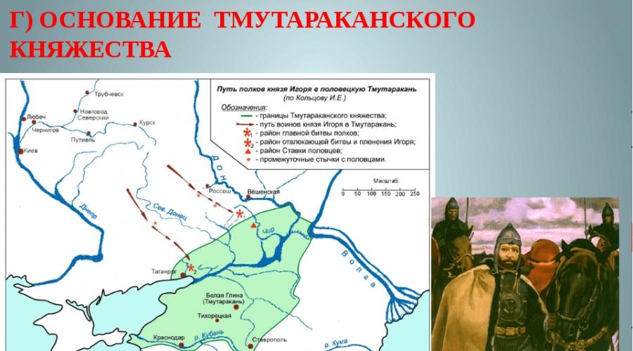
Svyatoslav and Vladimir created the Tmutarakan Principality in the territory of Taman and the Kerch Peninsula. Tmutarakan arose on the site of the Kamarhi Khazar settlement. A significant city in this period becomes Kortchev. Since that time, Slavs began to gradually settle in the Crimea.
However, the Kiev princes, directing the strength and energy to the union of the Slavic land of the Dnieper and the fight against nomads, gradually lost its position in Tarak. If with Vladimir the Red Sunny Crimea, according to Karl Marx, belonged to Russia, then in the XII century. Most of the peninsula became Polovotsky (Kipchakovskaya). The name of Kypchakov still in the XIX century. Wears 23 Crimean villages. Name of Mount Ayu Dag (Bear Mountain) Many researchers are asking for Polovtsy. From there, the famous Artek (on behalf of Artyk or Artuk - the son of Polovtsy Khan).

After weakening the Byzantium in its former Crimean possessions, Gotalans (Crimean Goths), the Orthodox Christian Principality of Feodoro with the capital was founded in the largest "cave city" of the city of Mangup.
1222 The first Turkish landing in Sudak, who defeated the Russian-Polovetsky army, is dating. Literally the next year, Tatar-Mongols Jebe invade the Crimea. They destroyed Sudak, who at that time was the richest of the Shoulder shopping centers, and in 1239, Crimea was completely conquered by Mongolian troops under the leadership of Khan Batya and became part of the Golden Horde. Polovtsy who lived in the territory of the peninsula were destroyed; Those who survived, subsequently joined the Crimean Tatar people.
During this period, the peninsula has developed a Turkic-speaking ethnic community, which became the core of the future of Crimean Khanate - the Crimean Tatars. Many peoples participated in the formation of an ethnic group: Scythians, Sarmatians, Goths, Huns, Avars, Seljuki, who came from Asia Minor, and others. They combined the nomadic lifestyle and the type of management. The people of the Crimean Tatars have developed after the peninsula was attached to the Golden Horde as a new ulus. At the beginning of the 14th century, the Crimean Tatars accepted Islam.
At the head of the Crimean ulus, which occupied the steppe of the peninsula, stood the governor of the Great Hang Golden Horde. The capital of the ulus was the city Crimea (translated from Mongolian "Strengthening") In the valley of the River Chuok-Su, shopping and administrative center. It was this city that gave the name to the entire Peninsula.

The steppe Crimea becomes the ownership of the Golden Horde - Ulus Juchi. The administrative center of the peninsula becomes the city of Crimea. The position of the conquered peoples of the peninsula became extremely heavy. The goldside conquerors laid themselves by their exorbitantly severe tribute to Yasakom, took out slaves and sold to other countries.
The first coins released in Crimea Khan Menhu Timur are dated 1267. Thanks to the rapid flowering of the Genuese trade and the Kamm's kafa located near the Kafa quickly turns into a major trading and craft center. Karasubazar becomes another major city of Crimean ulus. In the XIII century there is a significant Islamization of the previously Christian Crimea.
In the brilliant and multilingual salts (the old Crimea), a mosque was built, and by the middle of the century Solhat became the political center and the medium of Eastern culture on the peninsula. There was a bid of the governor of the Goldenordinian Khan, from here there was the spread of Muslim among the Tatars in the Crimea. After the collapse of the Golden Horde, the remains of Tatar-Mongols in Crimea were influenced by the Turkic speech and were turquisited. Then Mangup was the capital of the largest medieval Tauridian state - the Principality of Feodoro.
In the XIII century (1270), part of the territories of Crimea acquired the Genoese (Gazaria, Kaffa). Almost all the coast of Crimea was part of the Genoese colonies, they owned Sudakov (Solday), as well as Cherkio (Kerch). Genoese possessions were combined into the so-called "Gothia Captation" - a military administrative institution led by Caffa Coviffs appointed from Genoa. Kaffa (Feodosia) became the main city and the main port of the Genoesers. Their garrisons stood in Balaclava, Gurzufe, Alushta, Sudak. In the middle of the XIV century, they settled in close proximity to Kherson - in the Bay of Symbols, founding the fortress of Chamblock (Balaklava). The ruins of the Genoese fortresses in these cities remind us of this page in the history of the peninsula.
In the 14-15th centuries, the Genoese fell with the principality of the Feodoro struggle for the land on the southern coast of Crimea. During this period, Armenians and Adyg appeared on the peninsula.

By this time, the Polovtsian language was already widespread in the Crimea, which is evidenced by the Codex Cumanicus. In 1367, Crimea was subordinate to Mama, whose power also relied on the Genoese colonies. In 1380, Mamai suffered a defeat in the battle with the army of Dmitry Donskoy, and the power in Horde went to Tahtamysh, who appointed the governor to Crimea and concluded an agreement with the Genoese consul in a cafe. Under this Treaty, Tatars returned the territory in the area of \u200b\u200bSudak, taken away by Mama (the so-called "Gothian"), and the Gothic Genoes in the cafe were promised to be loyal to Khan.
In 1395, Tokhtamysh defeated Timur. Then he ruined the Golden Out, destroyed her the capital of the barn, and in the Crimea, who before that was the personal ownership of Takhtamysh, approved Khan Tashtimura, but in 1396 Tokhtamysh returned the peninsula. In 1397, Lithuanian Prince Vitovt invades the Crimea and comes to Caffs. After the pogrom, the Elder Chersonese turns into ruins (1399).
From that moment on, the Crimean Bai becomes quite powerful to show independence in Horde.
In the 15th century, the Golden Horde broke up into several independent political communities. In 1438, the Nogai were separated from it, which led the nomadic lifestyle and retained relative independence, and the Crimean Khanate.

The decay of the Golden Horde in 1441 allowed the Ottoman Empire to capture the Crimea, defeat the enemies of the Genoes, and the Crimean Khanate to make their protectorate. At this point, Crimea was divided between the Steppe Crimean Khanate, the Mountain Principality of Feodoro and the Genoese colonies on the south coast. The capital of the Principality of Feodoro was Mangup - one of the largest fortresses of the medieval Crimea (90 hectares), which, if necessary, tried to protect significant masses of the population.
In July 1475, Mangup was besieged by Ottoman Turks. Well fortified city was able to hold out in siege only three days and surrendered to the mercy of the winner. Bringing into the city, the Turks destroyed almost all the inhabitants, plundered and burned mangup. On the lands of the principality, Turkish Kadyelk (district) was formed. Mangup was located on the top of the mountain of the same name in the Bakhchisara district. In addition to the citadel, the martial cazate caases, the remnants of powerful defensive walls and towers, the princely palace, residential estates, a large temple are preserved. This is a grand monument.
Capturing one after another coastal fortress, the Turks put an end to the Genoese dominion in the Crimea. Decent resistance met the Turkish army at the walls of the capital of Feodoro. Capturing the city after six months of the siege, they ruined him, the inhabitants killed or took into slavery. Crimean Khan became Vassal Turkish Sultan.
For three subsequent centuries, the Black Sea became the Turkish "inland lake".

Khan became Mengly-Gary, who recognized in 1478 the Supreme Power of the Turkish Sultan on the following conditions: only a representative of the genus of the genus could be Khan; Khan possessed the right to appoint officials, but could not begin the war himself and conclude the world, Sultan prescribed the highest clergy; Sultan could send Khan and his army to war, providing content; Han kept his personal guard, Sultan contained his garrison in Evpatoria.
The Genoese colonies and the Principality of Feodoro disappeared from the map of the peninsula, and the Turkish military administrative authority was formed on their territory - Sanjak. He managed Sanjakan Turkish Pasha, who had a residence in Kef - the current Feodosia.
Capturing in the XV century. Taurika, Turks with the help of Italian specialists created a powerful strength of OR-KAPU at the sink. From this time, the second name has appeared at the Perekop Shaft - Turkish. From the end of the XV century. Turks and Tatars in Crimea are gradually moving from nomadic forms of farm to settle down agriculture.
Since the end of the 15th century, Crimean Khanate made permanent raids to the Russian state, the Grand Duchiness of Lithuania and the Commonwealth. The main purpose of the raids is to capture slaves and their resale in the Turkish markets. The total number of slaves passed through the Crimean markets is estimated at three million people. The main population during this period consists of a sedentary Tatar.
It took several centuries to eliminate this center of soloning Russian, Ukrainians, Polyakov and Lithuanians.

The main occupation of the Crimean Tatars (so they began to call much later) in the south there were horticulture, viticulture, tobacco production. In the steppe areas of the Crimea they had especially developed animal husbandry, primarily breeding sheep and horses, leather production.
The relations of the Crimean Khanate with the Russian state were contradictory: the Crimean Tatars often made raids on Russian lands, but in the fight against the Great Horde, the Moscow Prince and Crimean Khan opposed allies. In 1462, the Grand Duke Ivan III Vasilyevich and the Crimean Khan Haji Garyre exchanged diplomas. In 1485 and 1487, Ivan III sent troops to participate in the struggle of Crimean Hana with the Horde. In 1502, Mengly Garymen defeated the Horde, which after that ceased to exist.
Crimean Khanate constantly experienced the inner distribution during the struggle for power. Throughout the existence of Khanate, there was a constant struggle for power between the genus Shirin and Mansur. At the same time, relations with Ottoman Turkey remained unstable.
In 1532, Sakhib-Garyay I came to power, which rules until 1550 and held a number of reforms during this time.
In the 1550s, Crimean Khans fought with Ivan IV for Kazan and Astrakhan Khanate. Devlet-Garyay I made some trips to Rus, in 1571-1572 reached Moscow and burned it.
 Back in 1475, Gözlev was built (the Tatar name - Kezlev, then Evpatoria). He became the only seaport, through which the Crimean Khanate exercised trade on the Black Sea. Sahib-Girel contributed to the development of the city. Later, Khan Gazi-Garyay II moved there with his yard, and in 1591 he went from there to a campaign to Moscow. The defense of Moscow was led by Boris Godunov. The city was ready for the attack, and the Hang's campaign failed.
In the 17th century, differences in the life of the steppe and mountain-coastal Tatars took shape: mainly steppes and Crimean Nogai participated in the raids. Military prey (in particular, slave trade) was the most important source of enrichment for them. Mining and coastal Tatars were more engaged in agriculture.
The southern coast of the Crimea, the Kerch Peninsula, the northern slopes of the Crimean Mountains from Inkerman to Feodosia constituted the ownership of the Turkish Sultan.
In 1641, Khan became Mohammed-Gire IV. He suffered the capital and the Mint of Gözleva in Bakhchisarai, where he built the palace. Bakhchisaray became a cultural, administrative and political center for the mountain Tatars. Here lived to know who was focused on Turkey.
In 1648, Bogdan Khmelnitsky appeared in the Crimea with a proposal to conclude the Union of Cossacks and Tatars against the Poles. Islam-Garyu III and Bogdan Khmelnitsky organized a number of campaigns to Polish lands. But after a few years, Bogdan Khmelnitsky handed over to the Zaporizhia Russia, thereby putting the Crimean Khanate in a difficult political situation: after the joining of Ukraine, the Russian borders were moved far to the south.
 Now Khana began to get closer to the responding and concluded an agreement on mutual assistance with it. But in the 1660s, the situation has changed: Poland wanted to win the Ottoman Sanidian possessions, Russia sought to conquer the Crimea. Periods of hostility were replaced by truce. In 1681, Turkey and Russia
Conducted a truce in Bakhchisara for 20 years. The contract contained the condition that the Cossacks will not oppose Russia on the side of the Tatars. Nevertheless, Russia was still going to fight against Turkey and the Crimea. Russia, Poland and Austria concluded the Union, in 1686 Russia pledged to break the Bakhchisakhai peace treaty. In fact, Russia for the first time openly declared its intentions to conquer the Crimea. In 1687, the army of Prince V.V. Golitsyn moved to the Crimea, but the campaign ended in failure.
Now Khana began to get closer to the responding and concluded an agreement on mutual assistance with it. But in the 1660s, the situation has changed: Poland wanted to win the Ottoman Sanidian possessions, Russia sought to conquer the Crimea. Periods of hostility were replaced by truce. In 1681, Turkey and Russia
Conducted a truce in Bakhchisara for 20 years. The contract contained the condition that the Cossacks will not oppose Russia on the side of the Tatars. Nevertheless, Russia was still going to fight against Turkey and the Crimea. Russia, Poland and Austria concluded the Union, in 1686 Russia pledged to break the Bakhchisakhai peace treaty. In fact, Russia for the first time openly declared its intentions to conquer the Crimea. In 1687, the army of Prince V.V. Golitsyn moved to the Crimea, but the campaign ended in failure.
The policy of the Russian Empire in relation to the Crimea was dictated by the reasons for both strategic and socio-economic nature: Russia sought to free themselves from the constant threat of Tatar raids, to get access to the Black Sea, to strengthen his position in confrontation with Turkey (including in the Caucasus and in Transcaucasia), master comfortable retail ports, expand trade connections and seize new markets.
The Azov campaigns of Peter I (1695-1696) who did not solve the Black Sea problem, once again emphasized the meaning of the Crimean direction. Mastering the Crimean Peninsula has become one of the most important foreign policy objectives of the Russian Empire in the XVIII century.
 During the Russian-Turkish War (1735-1739), the Russian Dnieper Army, which consisted of 62 thousand people and held under the command of General-Field Marshal Burchand Christopher Miniha, on May 20, 1736, took the assault of Ottoman fortifications from the renouncement, forced Sivash, and on June 17, Bakhchisarai occupied. Crimea was completely conquered, but the lack of food and the epidemic began forced the Russians to leave the Crimea.
In July 1737, the army was invaded in Crimea under the leadership of Field Marshal General Peter Lassi, applying the Army of Crimean Hana a number of defeats and capturing Karasubazar. But she was soon forced to leave the Crimea due to lack of supply.
In 1769, the Crimean Khan Kaplan-Girey made a raid to the southern regions of Russia. The attack was shot down. It was the last raid of the Crimean Tatars in the history of relations between Russia and the Crimea. After several important victories overwhelmed by Russian troops, the whole territory between the Dniester and the Danube was cleared of the Turk. Successful for Russia held hostilities and the sea (including the famous Chesmery
Battle of 1770).
 Despite the attempts of the Crimean Khanate and the Ottoman Empire to prevent the Russian colonization of the Northern Black Sea region by armed force, it actually began before in 1771, the Army of General-Annef V. M. Delgorukova took possession of Crimea, for which he subsequently received from Empress Catherine II Scha diamonds, diamonds to the Order of St. Andrey the First Called and the title of Crimea. The prince of Dolgorukov forced the Crimean Khan Selim to flee to Turkey and built his place of a supporter of Russia, Khan Sahib II Hire, who signed an agreement with Russia about the Union, receiving a promise of Russian military and financial assistance.
The Russian-Turkish war of 1768-1774 (under the command of Count P.A. Rumyantsev) laid an end to the Ottoman domination over the Crimea, and on the Küchuk-Kainardzhi peace treaty of 1774, Ottomans officially abandoned the claims on the peninsula. To Russia, the fortresses of Kerch and Ynikale, launched from the Azov to the Black Sea. The Kerch Strait became Russian, which was of great importance for southern Russian trade. Crimean Khanate was declared independent of Turkey. Former Ottoman possessions on the peninsula (South and Southeast Crimea) were transferred to Crimean Khanty. The historical task of Russia's exit to the Black Sea half was solved.
 It took, however, a lot of time, funds and efforts (both military and diplomatic), before Turkey resigned with the yield of Crimea and the Northern Black Sea region from under its influence. Turkish Sultan, being a Supreme Caliph, kept the religious power in his hands and the right to approve new Khanov, which left him the possibility of real pressure on the Crimean Khanate. As a result, Crimean know was divided into two groups - Russian and Turkish orientation, the clashes between which came to these battles, and attempts to newly approved Khanov to establish themselves in the Crimean throne led to the intervention of Russian troops on the side of Russian stories.
Having achieved the declaration of Independence of the Crimea, Catherine II did not refuse the thought of joining it to Russia. This was required by the vital interests of Russia, because the Crimea had a large military-political and economic importance for the Russian state. Without the Crimea, it was impossible to have a free way out to the Black Sea. But the Sultan Turkey, in turn, did not think to abandon the Tauride Peninsula. She resorted to different tricks to restore their influence and domination in the Crimea. Thus, despite the presence of a Küchuk-Kainardgian peace treaty, the struggle between Russia and Turkey did not weaken from the Crimea.
 The last Crimean Khan was Shahin Garyre, who received the throne in 1777 due to Russian support. Student in Thessaloniki and Venice, who knew several languages, Shahin Garyray Rules, not believing with the national Tatar customs, tried to hold the reform in the state and reorganize the Office of the European Pattern, to equalize the Muslim and non-Muslim population of the Crimea, and soon turned to his people in the traitor and an assignment.
In March 1778, Alexander Suvorov was appointed commander of the Russian troops of Crimea and Kuban, who radically strengthened the defense of the peninsula from the Turkish attack and forced the Turkish fleet to leave the Crimean Waters.
In 1778, Suvorov, at the direction of Prince Pottemkin, at that time, who held the post of the governor (Governor-General) of the Novorossiysk, Azov, Astrakhan and Saratov province, contributed to the transition to the Russian citizenship and resettlement of the Christian population of Crimea (Armenians, Greeks, Volokhov, Georgians) to new Earth of the coast of the Azov Sea and the mouth of Don (the project was originally proposed by Catherine II in March 1778 by Paul-General Field Marshal Count Rumyantsev). On the one hand, it was caused by the need for an accelerated settlement of the fertile lands of the Northern Black Sea region (primarily the land of the liquidated Zaporizhzhya Steeper, empty due to the departure of the Paroxian Cossacks for the Danube and the eviction of the rest for Kuban). On the other hand, the conclusion from the Crimea of \u200b\u200bArmenians and Greeks was aimed at the economic weakening of the Crimean Khanate and strengthening its dependence on Russia.
 SUVOROVA ACTIONS caused the rage of Shahin Hires and a local Tatar nobility, because with the departure of the economically active part of the population, the treasury has lost significant sources of income. In the quality of compensation "for the loss of subjects", Khanu, his brothers, Baking and Murzam from the Russian treasury was paid 100 thousand rubles. From May to September 1778, 31 thousand people were resettled from Crimea in Priazovye and in Novorossia. Greeks, who inhabited mainly the Western and Southern Coast of Crimea, suvorov sewed on the north shore of the Azov Sea, where they founded the city of Mariupol and 20 villages. Armenians who inhabited mostly eastern and southeastern regions of Crimea (Feodosia, Old Crimea, Surkhat, etc.), settled in the lower reaches of Don, near the fortress Dmitry Rostovsky, where they founded the city of Nakhichevan-on-Don and 5 villages around Him (on the site of modern Rostov-on-Don). With the outcome of Christians, Khanate turned out to be bleed and ripped.
March 10, 1779 Russia and Turkey signed the Ainala Cavaca Convention, according to which Russia had to withdraw his troops from the Crimean Peninsula and, like Turkey, do not interfere in the internal affairs of Khanate. Turkey recognized the Shahin Hire of Crimean Khan, confirmed the independence of the Crimea and the right of free passage through Bosporus and Dardanelles for Russian commercial ships. Russian troops, leaving a six-thousand garrison in Kerch and Yenikale, in mid-June 1779 left Crimea and Kuban.

In the fall of 1781, another uprising occurred in Crimea, provoked by Turkey. In the summer of 1782, Ekaterina II instructed the prince of Potemkin to direct Russian troops to help overthrow Khana Shahin Hire, risking at the same time to go to an open conflict with Turkey. In September, with the help of Russian troops, Han Shahin Garyra returned his throne.
The continuing, however, the threat from Turkey (for which the Crimea was a possible bridgehead in the event of an attack on Russia) forced to build powerful fortified lines on the southern borders of the country and distracted the forces and means from the economic development of the border provinces. Potemkin as the governor of these areas, seeing the complexity and instability of the political situation in Crimea, came to the final conclusion about the need to access it to Russia, which would completed the territorial expansion of the Empire to the south to natural borders and created a single economic region - the Northern Black Sea region. In December 1782, returned from Kherson, Potemkin turned to Catherine II with a memorandum, which expressed his point in detail.
 The base for the implementation of this plan lying in the course of the so-called Greek project, which provided for the restoration of the Byzantine Empire with the capital in Constantinople and the Russian famitian on the throne, was prepared by the entire previous work of Potemkin in the settlement of Novorossia, the device for fortresses and economic development. It was why it thus belonged to the main and decisive role in the accession of the peninsula to Russia.
On December 14, 1782, the Empress sent Potemkin "the secret" rescript, in which she declared his will "for the assignment of the peninsula". In the spring of 1783, it was decided that Potemkin would go south and would personally manage the accession of the Crimean Khanate to Russia. On April 8 (21), the Empress signed the manifesto "On the adoption of the Crimean Peninsula, the island of Taman and the entire Kuban side under the Russian power", over which she worked together with Potemkin. This document was supposed to be kept secret until the joining of Khanate would be a favorable fact. On the same day, Potemkin went to the south, but even on the way he received an unexpected news about the renunciation of Shahin Giray from Khanate. The reason for this was the open hatred of subjects regarding the reforms and policies of Shahin Gurya, the actual financial bankruptcy of the state, mutual distrust and misunderstanding with the Russian authorities.
At the end of February 1783, the last Crimean Khan from the genus Gireev - Shagin Gary - signed a renunciation from the throne and left Bakhchisarai. A significant part of the Muslim population emigrated to Turkey.
 Believing that the greatest difficulties may arise in Kuban, Potemkin gave orders to Alexander Suvorov and his relative P. S. Potemkin to put forward troops to the Right-Bank Kuban. Having received the order of Prince, Suvorov took the troops of strengthening the former Kuban line and began to prepare the Nogai to the oath to the appointed day of the day - June 28, the Day of Ekaterina II for the throne. At the same time, the commander of the Caucasian Corps of P. S. Potemkin was supposed to take the oath in the headwinds of Kuban.
Russian troops were also introduced into the territory of the Crimea under the command of General-lieutenant Graph de Balme. In June 1783, the Karasubazar, Prince Potemkin, took the oath for the loyalty of Russia of Crimean nobility and representatives of all the layers of the Crimean population. The Crimean Khanate ceased to exist, but his top (over 300 genera) joined the Russian nobility and participated in the local self-government of the newly created Tavrichesky region.
Under order of Catherine II, urgent measures were taken to choose the harbor for the future of the Black Sea Fleet on the south-west coast. Captain II rank I. M. Bersenev on the frigate "Careful" recommended to use the bay from the village of Ahtiir, not far from the ruins of Chersonese-Tavrichesky. Ekaterina II of his decree dated February 10, 1784 was ordered to establish here "Military port with Admiralty, shipyard, fortress and make it a military city." In early 1784, a port-fortress was laid, which Catherine II gave the name Sevastopol.
At first, the arrangement of the Russian Crimea conducted Prince Potemkin, who received the title of "Tavrichesky".
 In the Crimea began to come to rest and live the highest ranks and titles of the Russian state: Potemkin, Vorontsov, Yusupov, Alexander III and many others. We all know the magnificence of Livadia, Vorontsovsky, Massandrovsky and dozens of other palaces and temples built by them.
In 1783, the population of Crimea consisted of 60 thousand people engaged in mostly cattle breeding (Crimean Tatars). At the same time, the Russian, as well as the Greek population from the number of retired soldiers began to grow under the Russian jurisdiction. New lands of Bulgarians and Germans come to master.
In 1787, Empress Catherine accomplished his famous journey to the Crimea.
In 1787, Turkey began a new Russian-Turkish war 1787-1791 in order to return the Crimea and other territories. The war ended with the Yasine Mir of 1792 (concluded on 9.01.1792 in Issa), who confirmed the accession of the Crimea and Kuban and established the Russian-Turkish border according to R. Dniester.
 In May 1791, Ekaterina II solemnly entered the Crimea, accompanied by the Austrian Emperor Joseph II, English and French ambassadors, representatives of other powers. The arrival of the Empress in Bakhchisaray became the climitation of the journey undertaken to show foreign powers newly acquired Tavrid, military power of the Russian Empire, her victorious fleet on the Black Sea. The joining of the Crimea completed the age-old struggle of Russia for entering the Black Sea, finally consolidated the southern borders of the Russian state. According to a new administrative division, the capital of the Crimean county was the new city of Simferopol (founded in 1784 on the site of the Tatar village of Ak-Mosque).
From April 2, 1784, the territory was divided into the treasures, there were 1400 settlements and 7 cities - Simferopol, Sevastopol, Yalta, Evpatoria, Alushta, Feodosia, Kerch.
In 1796, the region entered the Novorossiysk province, and in 1802 again allocated to an independent administrative unit. At the beginning of the XIX century, viticulture (Magarach) and shipbuilding (Sevastopol) are developing in the Crimea, roads are laid. At Prince Vorontsov, Yalta begins to be equipped, the Vorontsov Palace is laid, and the South Coast of the Crimea turns into a resort.
By 1853, 43 thousand people were Orthodox, in the Tavrician province among the "Inoverts", Roman Catholics, Lutherans, Reformeds, Armenian Catholics, Armenian-Grigoryan, Mennonites, Jews Talmudists, Karaim and Muslims were held.
In June 1854, the Anglo-French flotilla began to fill the Russian coastal fortifications in the Crimea, and already in September, the landing of the allied landing (United Kingdom, France, Ottoman Empire) began in Evpatoria. Soon there was a battle on Alma. In October, the siege of Sevastopol began, during which Kornilov died on Malakhov Kurgan. In February 1855, Russians unsuccessfully tried to storm Evpatoria. In May, the Anglo-French fleet capture Kerch. In July 1855, the chief inspirationor of Defense Admiral Nakhimov dies in Sevastopol. On September 11, 1855, Sevastopol fell, however, Russia was returned at the end of the war in exchange for certain concessions.
 In 1874, Simferopol was connected to Alexandrovsky (current Zaporizhia) railway.
In 1892, the janka-kerch railway movement began, which led to a significant acceleration of the Crimea's economic development. By the beginning of the 20th century, 25 million puddles of bread were taken out annually from the Crimean Peninsula. At the same time, especially after the purchase in 1860, Livadia Tsarist surname, Crimea turned into a resort peninsula. On the south coast, the Crimea began to relax the highest Russian to know for which the magnificent palaces in Massandra, Livadia, Mishore were built.
According to the population of 1897, 546,700 people lived in the Crimea. Of these, 35.6% of the Crimean Tatars, 33.1% of Velikorsov, 11.8% of Maloros, 5.8% of the Germans, 4.4% of Jews, 3.1% of the Greeks, 1.5% of Armenians, 1.3% Bulgarians , 1.2% of Poles, 0.3% of the Turks.
By the end of the XIX century, the Tauride province consisted of Berdyansky, Dniprovsky, Pokock, Simferopol, Feodosi and Yalta counties. The center of the province was the city of Simferopol.
On the eve of the revolution, 800 thousand people lived in Crimea, including 400 thousand Russians and 200 thousand Tatars, as well as 68 thousand Jews and 40 thousand Germans. After the February events of 1917, the Crimean Tatars organized in the Milli Fed Party who tried to capture power on the peninsula.
 On December 16, 1917, the Bolshevik Military Revolutionary Committee was established in Sevastopol, who took power into his hands. On January 4, 1918, the Bolsheviks took power in Feodosia, knocking out Crimean-Tatar compounds from there, and January 6 - in Kerch. On the night of January 8, January 9, the Red Guard joined Yalta. On the night of January 14, they took Simferopol. The SSR Tavrida was established in Crimea.
On April 22, 1918, Ukrainian troops under the command of Colonel Bobobian were taken by Evpatoria and Simferopol, followed by the German troops of General Cosha's background. By agreement between Kiev and Berlin on April 27, Ukrainian parts left the Crimea, refusing claims to the peninsula. Crimean Tatars rebelled and enclosing a union with new invaders. By May 1, 1918, German troops occupied the entire Crimean Peninsula. May 1 - November 15, 1918 - de facto Crimea under the German occupation, de Jura under the control of the autonomous Crimean regional government (from June 23) Suleiman Sulkevich
November 15, 1918 - April 11, 1919 - the second Crimean regional government (Solomon Crimea) under the patronage of the allies;
In April-June 1919 - Crimean Soviet Socialist Republic as part of the RSFSR;
July 1, 1919 - November 12, 1920 - the Government of the South of Russia: the German A. I. Denikin.
 In January-March 1920, 4 thousand fighters of the 3rd Army Corps of the North General of the 3rd Army Corps successfully defended the Crimea from the attacks of the two Soviet armies with a total number of 40 thousand fighters with the ingenious tactics of their commander, once at a time giving the Bolsheviks Perekop They are already in the Crimea, and then expelled from it back into the steppe. On February 4, the White Guard Captain Orlov and 300 fighters raised the rebellion and captured Simferopol, arresting several generals of the Volunteer Army and the Governor of the Tauride province. At the end of March, the remnants of the white armies, passing Don and Kuban, were evacuated to the Crimea. Denikin's bid was in Feodosia. On April 5, Denikin announced his resignation and transfer of his post to General Wrangel. On May 15, a challenge of the Vrangelev fleet took place on Mariupol, during which the city was shelling and the LDOW of some vessels in the Crimea. On June 6, parts of the wealth began to quickly move north, taking on June 10, the capital of Northern Tavria - Melitopol. On June 24, Berdyansk was taken by Vrangelev district for two days, and in July, the landing group of Captain Kochetov landed at Ochakov. On August 3, the white took Alexandrovsk, but the next day were forced to leave the city.
On November 12, 1920, the Red Army broke the defense at the silence and broke into the Crimea. November 13, the 2nd Equestrian Army under the command of F. K. Mironova took Simferopol. The main Worldwide troops through the port cities left the peninsula. In the captured Crimea, the Bolsheviks were learned by mass terror, as a result of which, in various data, from 20 to 120 thousand people were killed.
At the end of the Civil War in Crimea lived 720 thousand people.
 Hunger 1921-1922 Has the life of more than 75 thousand Crimeans. The total number of those killed in the spring of 1923 may exceed 100 thousand people. The consequences of hunger were eliminated only by the mid-1920s.
On August 18, 1941, 60 thousand Crimean Germans were deported on the order of Stalin from the peninsula.
In November 1941, the Red Army was forced to leave the Crimea, retreating on the Taman Peninsula. Soon, a counter-offensive was undertaken from there, but it did not led to success and Soviet troops were again discarded for the Kerch Strait.
In the occupied Germans, the same name was formed by the General District as part of the Rekhomissariat of Ukraine. He headed the occupation administration A. Frauenfeld, but in fact power belonged to the military administration. In accordance with Nazi politics in the occupied territory, the communists and racial unreliable elements were destroyed (Jews, Gypsies, Crimea, and together with Crimeans, the masses were also killed by Hitler Rovo-Raisen Karaimov).
On April 11, 1944, the Soviet army began an operation to liberate the Crimea, was repulsed by Janka and Kerch. By April 13, Simferopol and Feodosia were liberated. May 9 - Sevastopol. The longest of the Germans held at Cape Chersonesos, but their evacuation was torn by the death of the convoy "Pathia".
War sharply aggravated interethnic contradictions in the Crimea, and In May-June 1944, the Crimean Tatars were evicted from the Peninsula (183 thousand people), Armenians, Greeks and Bulgarians. Decree of the Presidium of the Supreme Soviet of the USSR No. 493 dated September 5, 1967 "On the citizens of the Tatar nationality living in Crimea" recognized that "after liberation in 1944, the Crimea from the fascist occupation facts of active cooperation with the German invaders of a certain part of the Tatars living in the Crimea were unreasonable To the entire Tatar population of Crimea. "
In February 1945, a conference of the heads of three powers - the USSR, the United States and the UK was held in the Livadia Palace. On the Crimean (Yalta) conference, decisions were made related to the completion of the war with Germany and Japan and the establishment of post-war world order.
 In 1954, "Taking into account the community of economy, territorial proximity and close economic and cultural ties between the Crimean Region and the Ukrainian SSR", Khrushchev handed the Crimea to the Ukrainian SSR.
 On January 20, 1991, a general-grade referendum was held in the Crimean Region of the Ukrainian Soviet Socialist Republic. The question was issued to the universal vote: "Are you for the reconstitution of the Crimean Autonomous Soviet Socialist Republic as a subject of the Union of SSR and the participant of the Union Treaty?". The referendum raised the decision of the Presidium of the Supreme Soviet of the USSR from 1954 (on the transfer of the Crimean Region to the Ukrainian SSR), and from 1945 (on the abolition of the CRESSR, and the creation of the Crimean Region instead). The referendum was attended by 1 million 441 thousand 19 people, which is 81.37% of the total number of citizens enrolled in the lists to participate in the referendum. The recreation of the Crimean ASSR voted 93.26% of the inhabitants of the Crimea from the total number of participation in the voting.
On February 12, 1991, on the basis of the results of the general referendum, the Verkhovna Rada of Ukraine adopted the law "On the restoration of the Crimean Autonomous Soviet Socialist Republic", and after 4 months, the relevant changes to the Constitution of the Ukrainian SSR 1978. Nevertheless, the second part of the issue issued to a referendum is to increase the status of Crimea to the subject of the subject of the USSR and the participant in the Union Treaty - in this law was not taken into account.
On September 4, 1991, the emergency session of the Supreme Soviet of the Autonomous Republic of Crimea adopted a declaration on the state sovereignty of the republic.
On December 1, 1991, in the All-Ukrainian referendum, the residents of Crimea participated in the voting about the independence of Ukraine. 54% of Crimeans spoke in favor of preserving the independence of Ukraine - the UN Founded State. However, Article 3 of the USSR Law "On the procedure for solving issues related to the yield of the Federal Republic of the USSR was violated, according to which the Soviet Referendum should have been held in the Crimean ASSR on the issue of its stay in the USSR or in the exit of the Federal Republic of the Republic - Ukrainian SSR.
On May 5, 1992, the Supreme Council of the Autonomous Republic of Crimea adopted the Declaration of "Act on the Proclamation of State Independence of the Republic of Crimea".
At the same time, the Russian Parliament voted to abolish the decision on the transfer of Crimea to the Ukrainian SSR from 1954.
 May 6, 1992 The seventh session of the Supreme Soviet of the Autonomous Republic of Crimea adopted the Constitution of the Republic of Crimea. These documents were contrary to the then legislation of Ukraine, they were canceled by the Supreme Rada of Ukraine only on March 17, 1995. Subsequently, Leonid Kuchma, who later became the president of Ukraine in July 1994, signed a number of decrees, which determined the status of the authorities of the ARC.
Also May 6, 1992. The post of President of the Autonomous Republic of Crimea was introduced by the decision of the Supreme Soviet of the Autonomous Republic of Crimea
February 4, 1994 President of the Republic of Crimea elected Yuri Bags.
March 27, 1994 A referendum was held in Crimea simultaneously with the elections to the Regional Parliament (English) and with elections to the Ukrainian parliament.
In March 1995 By the decision of the Verkhovna Rada of Ukraine and the President of Ukraine, the Constitution of the Republic of Crimea from 1992 was canceled, the presidency in the Crimea was abolished.
October 21, 1998 At the second session of the Verkhovna Rada of the Republic of Crimea, a new constitution was adopted.
December 23, 1998 President of Ukraine L. Kuchma signed the law in the first paragraph of which the Verkhovna Rada of Ukraine decided: "To approve the Constitution of the Autonomous Republic of Crimea", pro-Russian sentiment intensified in Crimea.
February 23, 2014 The Ukrainian flag was launched over the city council of Kerch and raised the state flag of the Russian Federation. Mass removal of Ukrainian flags occurred on February 25 in Sevastopol. With a sharp criticism of the new authorities in Kiev, the Cossacks in Feodosia appeared. The inhabitants of Evpatoria also connected to the pro-Russian shares.
February 27, 2014and the building of the Supreme Council of Crimea was captured by armed people without signs of difference. Employees of the Ministry of Internal Affairs of Ukraine, guarding the building, were expelled, the Russian flag was raised over the building. The captured missed inside deputies of the Supreme Soviet of the Crimea, having previously revealed to their mobile communications. Deputies voted for the appointment of Aksenov the head of the new government of Crimea and decided to hold a referendum on the status of the Crimea. According to the official statement of the press service of the VSK, 53 deputies voted for this decision. According to the Speaker of the Krymsky Parliament, Vladimir Konstantinova, V. F. Yanukovych (which parliamentarians are considered to be president of Ukraine), and by telephone coordinated the candidacy Aksenov. This coordination requires Article 136 of the Constitution of Ukraine.
March 6, 2014 The Supreme Council of Crimea adopted a resolution on the entry of the republic to Russian Federation
As its subject and appointed a referendum on this issue.
March 11, 2014 The Supreme Council of the Autonomous Republic of Crimea and the Sevastopol City Council adopted the Declaration on the independence of the Autonomous Republic of Crimea and the city of Sevastopol.
On March 16, 2014, the referendum was held in Crimea, in which about 82% of voters took part in the official data, of which 96% voted for joining the Russian Federation. On March 17, 2014, according to the results of the referendum, the Republic of Crimea, in which the city of Sevastopol has a special status requested the accession to Russia.

On March 18, 2014, an interstate agreement was signed between the Russian Federation and the Republic of Crimea on adoption in the Russian Federation of the Republic of Crimea. In accordance with the agreement in the Russian Federation, new subjects are formed - the Republic of Crimea and the city of federal significance Sevastopol. On March 21, the Federal District was formed in the Crimea with the center in Simferopol. After the joining of Crimea, the question arose about the fate of the Ukrainian military units located on the territory of the peninsula. Initially, these parts were blocked by local self-defense troops, and then taken by storm. During the storm parts, the Ukrainian military behaved passively and the weapons did not use. On March 22, the Russian media reported anger among Crimeans, who sought Russian passports. March 24 In the Crimea, the ruble became official currency (the hryvnia was temporarily preserved).

The modern history of the Crimea continues to be formed in our eyes. Not all countries still recognized the status of the Crimea. But Crimeans live with faith in a bright future.
Crimea today is the blessed land of the Crimean Peninsula, washed by the Black and Azov seas. In the north, it extends plain, in the south - Crimean mountains with a necklace at the coastal strip of seaside cities of resorts.
The natural museum is called the nature of the Crimea. There are few places in the world, wherever the most commonly combined, comfortable and picturesque landscapes. In many ways, they are due to the originality of the geographical position, geological structure, relief, the climate of the peninsula. Crimean mountains divide the peninsula into two unequal parts. Large - North - located in the extreme south of the moderate belt, the South-Crimean subsensher - refers to the northern outskirts of the subtropical belt.
The Crimean Peninsula is provided with plenty of heat not only in summer, but also in winter. In December and January, there are 8-10 times more, for example, in St. Petersburg in St. Petersburg for a day than, for example, in St. Petersburg. The greatest amount of solar heat is the Crimea in the summer, especially in July. Spring here is cooler autumn. And autumn is the best season of the year. The weather quiet, solar and moderately warm.
As of January 1, 2015, the population of Crimea was 2,294,888 permanent residents, including in the Republic of Crimea - 1,895,915 permanent residents, in Sevastopol - 398,973 permanent residents.

Crimea today is the blessed land of the Crimean Peninsula washed by black and the Azov seas. In the north, he extends plain, in the south - Crimean mountains with a necklace at the coastal strip of seaside resort cities: Yalta, Mishor, Alusta, Simeiz, Gurzuf, Alushta, Feodosia, Evpatoria and seaports - Kerch, Sevastopol.
Crimea is located within 44 ° 23 "(Cape Sarych) and 46 ° 15" (Perekopsky) northern latitude, 32 ° 30 "(Cape Karamrun) and 36 ° 40" (Cape Lantern) Eastern longitude Square of the Crimean Peninsula is 26.0 thousand km. The maximum distance from the north to south is 205 km, with the West and East - 325 km.
A narrow eight-kilometer strip of sushi to the north (Perekopsty) connects the Crimea with the mainland a 4-5 km - the width of the Kerch Strait in the East (the length of the strait is about 41 km) - separate it from the Taman Peninsula. The overall length of the borders of the Crimea exceeds 2500 km (including the extreme toast toast lines of the North-East). In general, the coast of the Crimea is small, the Black Sea forms three large bays: Carcinite, Kalaytsky and Feodosia; The Azov Sea is also formed by three bays: Kazantipsky, Arabat and Sivash.
The physico-geographical position of the Crimea as a whole differs in the following most characteristic features. First, finding a 45 ° northern latitude peninsula causes its equivalence from the equator and the North Pole, which is associated with a sufficiently large number of incoming solar energy and a large number of solar shine hours. Secondly, Crimea is almost an island. It is connected with this, on the one hand, a large number of endem (plant species, which have not found anywhere, except for the locality) and endemics (similar species of animals); On the other hand, this explains the significant depletion of the Crimean fauna; In addition, the climate and other components of nature have a significant impact of marine environment. Thirdly, the position of the peninsula relative to the overall circulation of the Earth's atmosphere, leading to the predominance of Western winds in the Crimea, is particularly important. Crimea occupies a border position between moderate and subtropical geographical belts.
The peculiarities of the transport and geographical position of the Crimea in the past caused the nature of the population of the peninsula and the specifics of its farm. In the Middle Ages, Crimea was a kind of deadlog on the path of many nomadic tribes. Many have seen here and perceived local languages, culture and religion.
The sea environment of the Crimea led not only the peculiarities of external economic ties, but also the development of seaside recreation. Through the Danube Rivers and the Dnieper, Crimea has access to the ports of the countries of Central European, Baltic and Scandinavia, and through the Don and the system of channels of European Russia - to the Baltic and White Seas, the Caspian states.
A favorable feature of the economic and geographical position of Crimea is its neighborhood with economically developed Kherson and Zaporizhia regions of Ukraine and with the Krasnodar Territory of the Russian Federation.
The natural museum is called the nature of the Crimea. There are few places in the world, wherever the most commonly combined, comfortable and picturesque landscapes. In many ways, they are due to the originality of the geographical position, geological structure, relief, the climate of the peninsula. Crimean mountains divide the peninsula into two unequal parts. Large - North - located in the extreme south of the moderate belt, the South-Crimean subsensher - refers to the northern outskirts of the subtropical belt.
Especially rich and interesting was the plant world of Crimea. Only wild-growing higher plants are more than 65% of the flora of the entire European part of the countries of the Commonwealth. Along with this, about 1000 species of foreign plants are cultivated here. Almost all Flora Crimea focuses in its southern mountainous. This is a truly museum wealth of Flora.
The climate of most of the Crimea is a climate of a moderate belt: soft steppe - in the flat part; More weta, characteristic of deciduous forests - in the mountains. The southern coast of the Crimea is peculiar to the subsened-free climate of dry forests and shrub thickets.
Crimea, especially its mountainous part, thanks to the comfortable climate, saturation of clean air, toned by phytoncides, sea salts, pleasant aroma of plants, has a great healing force. Earthly subsoil is also containing healing dirt and mineral waters.
The Crimean Peninsula is provided with plenty of heat not only in summer, but also in winter. In December and January, there are 8-10 times more, for example, in St. Petersburg in St. Petersburg for a day than, for example, in St. Petersburg. The greatest amount of solar heat is the Crimea in the summer, especially in July. Spring here is cooler autumn. And autumn is the best season of the year. The weather quiet, solar and moderately warm.
True, sharp fluctuations in pressure during the day exacerbate cardiovascular diseases in people, not quite healthy. In the Crimea, well-provided heat, biological productivity of plants, including crops, stability of landscapes to loads largely depend on the amount of moisture. And the need for water is constantly increasing at the local population, and the national economy, primarily rural and resort. So water in the Crimea is a genuine engine of life and culture.
A relatively small amount of atmospheric sediment, long dry summer, distribution in the mountains of the cruising rocks led the poverty of the Crimea with surface waters.
Crimea is divided into two parts: flat steppe with a very small number of surface watercourses and mountain forest with a relatively thick river network. There are no large fresh lakes. In the seaside strip of the plain Crimea there are about 50 lakes with a total area of \u200b\u200b5.3 thousand km2.
Crimea has 1657 rivers and temporary watercourses with a total length of 5996 km. Of these, about 150 rivers are river-dwarfs up to 10 km of length. Only the Salgir River has a length of more than 200 km. The river network is developed on the peninsula extremely unevenly.
Depending on the direction of the flow of surface water, the division of the rivers of the Crimea into three groups is taken: the rivers of the northwestern slopes of the Crimean Mountains, the rivers of the southern coast of Crimea, the rivers of the northern slopes of the Crimean Mountains.
All rivers of the northwestern slopes flow almost in a parallel to each other. Around the middle of its current, they have the kind of typical mountain streams. The largest of them are Alma, Kacha, Belbek and black.
The rivers of the South Coast of the Crimea are short, have very steep biases of the bed, a rapid temper in a flood.
In the West, in addition to usually dry ravines and the creek Khastabash, the river is the river Study-Su. Rapidly escaping to the sea, it forms in four places of the waterfalls. The topmost and largest part-su (bat).
The rivers of the northern slopes of the Crimean Mountains are distinguished by the fact that outside the mountains are deviated to the east and fall into Sivash - the Lagoon of the Sea of \u200b\u200bAzov. In the upper reaches of the river constantly with water, and within the same plain in the summer there are often dry beds.
Salgir is the longest river of Crimea. Together with the influx of Biyuk-Karasu, it represents the largest water system in the Crimea. The Toppers Salgir are formed from the merger of the rivers of the Angara and Kizl-Koba. The village of Zarechnaya in Salgir is a major influx of Ayan.
Salgir fills a large Simferopol reservoir, built in 1951-1955. Below Simferopol, the river takes the right tributaries - River Bester Sheo, Burulcha, and 27 km from Sivas - Biyuk-Karasu. Tagigan and Belogorsk reservoirs are built on Biyuk-Karasu.
The population of the Crimea is located in unevenly. 50% of the Republic of the Republic lives on the coast. In the cities in 1991, 69% lived, in rural areas - 31% of the population. 43% of the population of Crimea lives in four major cities: Sevastopol (371.4 thousand people in 1991), Simferopol (357 thousand people), Kerch (189.5 thousand people) and Evpatoria (113.3 thousand people).
The Crimea is characterized by an increase in the number of cities and towns of urban type and the relative stability of rural settlements. In recent years, such cities like Sudak, Krasnoperekopsk, Armenian, Schelkino appeared on the map of Crimea. The number of urban villages is growing rapidly - since 1959 more than 2 times.
The main part of the population of Crimea is workers (about 60 percent), employees - 28, peasants - less than 11 percent.
Crimea has always been distinguished not only by the high specific weight of the urban population, but also a high level of literacy, the formation of residents. Each thousand inhabitants in cities accounted for 900, and in villages 730 people with higher, secondary special and secondary education.
The preparation of highly qualified specialists carry out 6 state higher educational institutions (Simferopol State University, Crimean Medical Institute, Crimean Agricultural Institute. Sevastopol Instrument Engineering Institute, Crimean Institute of Environmental and Resort Construction. Crimean State Industrial-Pedagogical Institute), two branches of universities - Kiev Economic University (in Simferopol) and Kaliningrad fishing (in Kerch), as well as several commercial universities.
Military specialists are preparing the Military Institute in Sevastopol and the Engineering and Construction School in Simferopol.
In recent years, colleges are created on a commercial basis. 30 secondary specialized educational institutions are engaged in training specialists. Proftechilitors prepare frames for 120 specialties.
The Crimea employs academic institutions and cultural institutions. In Simferopol there is the Crimean Department of the National Academy of Sciences of Ukraine, the Ethirmasslo Production Association, Krymniyproekt, in the village of Scientific - the Crimean Astrophysical Observatory and others.
There are several professional theaters and philharmonic, art gallery in Feodosia. A large number of newspapers are published. The publishing houses "Tavrida", "Tavria", "Crimeauzhedgiz" and others work. In Crimea, a large number of museums, many of which are associated with the fate of outstanding writers, artists, scientists who lived in the peninsula.
The economic appearance of the Crimea, the structure, the nature of the placement of industries and the population was built mainly in accordance with its natural and socio-economic conditions.
Until 1917, the republic's economy was mainly agricultural. Gradually, it turned into an industrial-agrarian.
Crimea is allocated by diversified rural and recreational economy, the production of calcined soda, titanium dioxide, sulfuric acid, technological equipment for the food industry, televisions, oceanic vessels, fish and fish products. In addition to engineering, chemical industries, rural and recreational economy, the sectors of specialization also include the food industry, producing grape wines, fruits and vegetables canned food, essential oils.
In the structure of industrial production, the leading place is owned by the food industry, then follow the engine structure and metalworking, the chemical industry, the building materials industry.
Crimea agriculture is specialized in the grain-livestock, viticulture, gardening, vegetable growing, as well as on the cultivation of essential oil cultures (lavender, roses, sage). The volumes of gross production of animal and crop production and crop production are balanced.
Maritime transport has important for the republic. Through the Crimean ports, export and import transport of various goods are carried out. The most important ports are Kerch, Feodosia, Yalta, Evpatoria. The largest city-port is Sevastopol.
Air transport Crimea is associated with all CIS countries and many foreign countries.
Recreational economy is one of the leading industries of the republic. From the Latin language, recreation is translated as "restoration", refers to the restoration of the physical and psychophysio-logical condition of the person. The recreational economy includes: sanatoriums, boarding houses, houses and recreation centers, tourgosts and tourism, campgrounds, children's camps. Recreational economy works on beach, balneological and climatic resources, healing mud, seawater, landscape resources.
Social infrastructure industry Crimea - utilities, domestic services, public education, public catering, trade, health care, social security, culture, physical education, lending and insurance, science and scientific services are characterized by a high level of development.