Cordillera Higher point Name. Mountain Cordillera - Characteristics
Cordillera Mountains are the longest mountain system in the world. If you look at the map, you can see that these mountains stretched almost 18,000 km.
MacKille (Cecil Sanders) view from the aircraft on Cordillera (Vivis Carvalho) Denali National Park (Denali National Park and Preserve) Cordillera (Ross Fowler) Ross Fowler Helicopter on the background of Cordiller (The US Army) Pablo Trincado Denali National Park (MAYKOL SaAvedra) View of Cordillera (Miguel Vera León) Lovely view of Mac-Kinlie Mac-Kinley Mountain, Denali National Park (Christoph Strässler) High Point Cordiller (Denali National Park And Preserve) Park Denali (Denali National Park and Preserve) Park Denali and Bear (Denali National Park and Preserve) Carlos Felipe Pardo Cordillera, Andes (Daniel Peppes Gauer) Cordillera (Nacho) Cordillera - Blanca, Peru (Mel Patterson) Cordillera Blanca, Peru (Mel Patterson) Cordillera Blanca, Peru (Mel Patterson)
What kind of mainland are they located? Cordillera is unusual because they are at once on two continents. If you look at the card, you can see that these mountains stretched almost 18,000 kilometers from north to south, along the Pacific coast of Northern and South America - from Alaska to the island of fiery land.
Cordillers are divided into two large systems - Cordillera North America and Cordillera South America are also widely known as Andes. As part of this article, only Cordillera North America will be described, spread from Alaska to South Mexico.
Cordiller height - the highest point
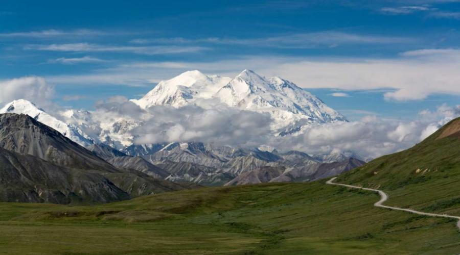
The highest peak of Cordiller North America is Mount Denali, until recently known as Mac-Kinley, the height of which is 6190 m. Its coordinates: 63 ° 04'10 "Northern latitude of 151 ° 00'26" Western longitude.

Mac-Kinley Mountain, Denali National Park (Christoph Strässler)
Geographic characteristic
The length of the mining system has almost 9,000 km with a width of 800 to 1600 km. At the same time, Canadian cordillers have the smallest width, and the maximum width of the mountains is achieved in the USA. Almost all in its entirety, these mountains form 3 belts - East, Western and internal.

View of Cordillera (Miguel Vera León)
The eastern belt, also known as the Rocky Mountain belt, forms a number of high mountain ranges, which are a watershed, separating the waters of the Pacific Ocean in the West and the pools of the Atlantic and North Ocean Oceans in the East. In addition to the Rocky Mountains themselves, it includes Brooks Ridge on Alaska, Richardson Ridge and Mackenzie Mountains in Canada, East Sierra Madre mountain system in Mexico. The highest point of the belt is the Elbert mountain, which is located within the state of Colorado. Its peak has an absolute mark of 4399 meters.
Western belt is presented with folded and volcanic ridges that pass in parallel with the coast of the Pacific Ocean. It includes Aleuta, Alaskan and coastal ridges, cascading mountains, Sierra Nevada mountain system, Western and Sierra Madre, transverse volcanic Sierra. Within the limits of the Alaskan ridge, there is the highest mountain of not only this belt, but also all of North America - Mount Denali (Mak-Kinley), the height of which has 6190 m.
The inner belt includes a number of plateau and a flatbed located between two other belts. It consists of Plateau Fraser, Columbia Mountains, Highlands Big Pool, Colorado Plateau and Mexican Highlands.
Three main mountain arcs Cordillere
In Central America and on the Islands of the Caribbean Sea, Cordillera disintegrate into three main mountain arcs that are separated by depressions.

Cordillera (Ross Fowler)
So, an arc, which is a structural continuation of the Rocky Mountains and Eastern Sierra Madre, forms the Mountains of Cuba Islands, the North of Haiti and Puerto Rico.
The South Sierra Madre geologically continues to the mountains of Jamaica, the south of Haiti, and they merge on Puerto Rico with the mountains of the first arc.
The third arc passes from the southern frontiers of Mexico through all countries of Central America to the West Panama. Its continuation are Andes.
Cordillera cross all the geographical belts of the continent, from the Arctic to the north to the subequatorial in the south. At their length, the climate of the terrain, vegetable and animal world change very much.
No less much natural conditions change when driving from west to east of the mountain system; Often climate and vegetation change in this direction much faster than when moving from north to south. In addition, as in all high mountains, high-quality exemplary here is of great importance.
Geology
Cordillera North America are composed of various geological structures of different ages. The mountains began to form in the Jurassic period, few earlier than the Andes whose education began only at the end of the chalk period.
Slap formation was not over to this day, the evidence of which is quite frequent earthquakes and the presence of existing volcanoes. Approximately north of Parallel 45 degrees of northern latitude, a considerable effect on the formation of the relief was provided by a quaternary glaciation.
In Cordillera, gold, mercury, tungsten, copper, molybdenum and other ores are mining. From non-metallic minerals there are fields of oil, stone coal, etc.
Hydrography
The Cordillera are the origins of such major rivers such as Yukon, Mackenzie, Missouri, Colombia, Colorado, Rio Grande and many others.

Denali National Park (Denali National Park and Preserve)
The north of the 50th latitude predominates the snow diet of watercourses, and to the south - rain. Many mountain rivers have great energy potential. Especially many hydroelectric power plants are built in the Columbia River Basin.
In the inner areas of the mining system there are large drawing areas. Unloading of a few watercourses that are mainly temporary, is carried out here in salt-free lakes, the largest of which is a large salt lake.
Pretty numerous and freshwater lakes: Atling, Okanangan, Kutena (Canadian Cordillera); Utah, Tahoe, Upper-Klamat (USA).
Climate
Because of a very high length in the meridional direction, the climate in Cordillera is greatly different. In Alaska, in Canada and North-West, the United States, on the Pacific slopes, the climate is characterized as rather mild and wet.

Denali National Park (Harvey Barrison)
The amount of precipitation on the islands off the coast of Canada and Alaska, as well as on the western slope of the coastal ridges exceeds 2000 mm, and in separate areas it can reach 6000 mm.
Maximum precipitation here falls for the winter, in connection with which, most of them falls in the form of snow. Winter is relatively warm and wet, and summer is cool and dry.
The average temperatures of July usually change from 13 to 15 degrees, and the average temperatures of January - from 0 to 4 degrees.
Away from the coast climate is very different; It is characterized as continental. On some plateau, the amount of precipitation does not exceed 400-500 mm. The winter here becomes more frosty, and the summer, on the contrary, is warm.

View of Cordillera (Maykol Saavedra)
In the southwest US climate is characterized as subtropical. The precipitation here also falls mainly in winter. Their number can reach in the Western slopes of the coast ranges up to 2000 mm, and in the West Sierra Nevada - up to 1000 mm.
In the rocky mountains, on the contrary, the eastern elephants receive more precipitation (700-800 mm) than Western (300-400 mm). This is due to the fact that air masses from the Atlantic Ocean reach the eastern slopes. Some deep inner basins get less than 200 mm of precipitation per year.
The most arid deserts of Mojave and Sonor, as well as the western part of the large pool. In some areas of these deserts, only about 50 mm of precipitation falls.
The climate of intermountain Kotlovin is characterized as sharply continental with very large daily and annual fluctuations in temperatures. In the interimathedral of the "Death Valley", the highest temperature in the world was recorded, which was 56.7 degrees, while in winter the temperature here is often lowered below the zero mark.
The total area of \u200b\u200bglaciers is more than 60,000 square kilometers. The height of the snow line changes from 300-450 meters on the coastal slopes of the mountains of the South and Southeast Alaska to 4500 meters and more - in Mexico.
In the rocky and cascade mountains in the United States, the snow line is located at an altitude of 2500-3000 meters, and in the mountains of Sierra Nevada - up to 4000 meters.
Flora and fauna
The churbed world of the Cordiller changes not only depending on the height above sea level, as in all other mountains; It also depends greatly on the latitude of a particular area and from its remoteness from the ocean.

Denali Park (Denali National Park and Preserve)
In the north of the mountain system, the slopes of the ridges are covered mainly by coniferous forests.
The inner platea, the USA plateau and the depressions and northern Mexico are engaged in the main arid steppes and deserts, which is explained by the rain shadow effect, due to which the wet air masses are delayed by high mountains and almost do not reach these areas.
For part of the coast of California and the North-West, Mexico is characterized by severe shrub vegetation, known as Chaparal.
On Western slopes in South Mexico and Central America are common both evergreen and deciduous tropical forests. On the eastern slopes and in intergranty basins, the vegetation is much more scarce and is represented by various shrubs, cactus and savannahs. Especially great variety of cacti and agave, which hundreds of species are found here.
The fauna of mountain forests is rather similar to the fauna of the plain North American Taiga. Here are a bears of Grizzly, foxes, wolves, beavers, wolverines, lynks, pums, etc. From characteristic only for mountains of species, mountain rams are found. The pums, coyotes, steppe wolves, hares, various rodents live in the steppes and deserts. Animal world of tropical forests is represented by various monkeys; From the predators here you can meet jaguar.

Beautiful view of McKinley (Christoph Strässler)
National Parks in Cordilleter
On the territory of Cordiller there are numerous national parks that attract millions of tourists from all over the Earth. The photos of local unusual landscapes are amazing even people, many smoking the world.
On the western part of the Sierra Nevada Mountains, one of the most famous national parks of the United States - Yosemite, which is famous for high granite rocks, waterfalls and just untouched nature.
South of it is located in the park Sequoia, the famous, how can I understand from the name, thanks to its giant sequoams. In the cascade mountains there is a Mount Reinir National Park, in whose territory the volcano is located. On the Colorado Plateau is the oldest US Park - Grand Canyon, which is the Canyon of the Colorado River.
Cordillera - This is the largest mountain system of the world.
what kind of mainland are mountains Alps, Andes, Cordillera, Ural, Scandinavian, Himalayas, Appach
It is located on the west coast of North and South America. That is, it is divided into two approximately equal parts. For this reason, sometimes the southern part of it, Andes, are called the longest mountain system (9000 km). This is partly true, because Andes like a separate object, and the truth has a greater length.
Description of the Cordillery Mountains
The length of the Cordiller is about 18 thousand km. Approximately 9 thousand km per each of its parts - they are almost equal.
But if we talk about the size as a whole, the northern part is larger - it is wider (up to 1600 km). But the south is a higher - 6962 meters at the highest point (Mount Akonkagua). In the north part of the Cordiller, the height reaches 6190 meters (Mount Denali), which is also quite a lot.
In general, at the height of this mining system among the leaders, although far from the first place.
As cordillers extend to huge distances, they lie in almost all geographic belts.
And this means that the conditions here are the most diverse. However, something similar is observed throughout the length of the mountains - glaciation. Even in the hottest climatic belts on the mountains there are snow caps (due to the relatively large height of the mountains). The total area of \u200b\u200bglaciation is 90 thousand km2.
Verses Cordiller
At least the highest points of the mining system and are located on six thousand meters, the average height of the mountains is 3-4 km. Although, the relief of this geological object is very diverse, so the designation of the height is quite conditional.
The highest peaks of the mountain system are:
- - Mount Akonkagua (extinct volcano) - 6962 meters.
- - Mount Denali (Mac-Kinley) - 6190 meters.
- - Okhos del Salado (the largest volcano of the world) - 6891 meters.
- - Monte-Pissis - 6792 meters.
- - Lewulaylyako (active volcano) - 6739 meters
- - Tupungato (active volcano) - 6565 meters.
- - Orizab Volcano - 5700 meters.
- - The system consists of a large amount of mountain arcs, which already gives some kind of uniqueness to Cordillera.
You can also note the presence of mountain ranges and kitelins, forming the increase and lowering of the relief - it is very interesting.
- - In Cordillera, there is quite high volcanic activity.
True, it is not about spewing volcanoes.
- - There are large stocks of non-ferrous and black metals in the mountains, as well as oil and brown coal.
- - Thanks to a large number of climatic belts, the roast world of the Cordiller is very diverse.
Andes or Andiy Cordillera (Cordillera de Los Andes) is the longest and one of the highest mountains of the Earth, restricting from the north and west of all southern America.
Andes mountain range rise in the West of South America and stretches at 6400 km from north to south.
Mountain Cordillera - the longest mountain system in the world
Only in one Ecuador 18 mountains rise above 4500 meters above sea level. To the west of the Andes - a narrow strip of the shore of the Pacific Ocean. On the eastern slopes take the beginning of the Amazon's tributaries, the main river of South America.
It is here before the appearance of Spanish conquistadors in the 1530s bloomed the great civilizations of Chimu and Incans, which only in the 1820s were able to free themselves from the domination of Spain.
Today, there are four independent states - Columbia, Ecuador, Peru and Bolivia.
They live as descendants of European settlers and Indians, such as Aimar and Kechua. The official language of these countries is Spanish.
The area is rich in natural resources and timber, but many people work for a very low fee. Here they grow corn, sugar cane, bananas, coffee, potatoes and grain, which is called Quinoa.
Where is and how to get there
Address: South America, Andiy Cordillera
Andes in South America on the map
GPS coordinates:-20.923594, -69.658586
Cordillera (Spanish Cordillera, literally mountainous areas), the largest and largest in the world, which is not the same in the world, is a mining system. The Cordillera Mountain System is also one of the highest mountain systems subordinated only by Himalayan and Mountain Systems of Central Asia.
Geography of the Cordillere Mining System
Cordillera extend from the Arctic coast on Alaska (66 ° S.Sh.
) In the north-west of North America along the Western Coast of North and South America, in most southern shores of the fiery land (56 °) south of South America. Cordillera on the road traveling through a number of countries on both continents: Canada, USA, Mexico, Central America, Venezuela, Colombia, Ecuador, Peru, Bolivia, Argentina, Chile.
The length of the mountain system Cordillero is more than 18,000 kilometers. The highest point is located in South America, on the top of the Akonkagua mountain at an altitude of 6,960 m above sea level, and the highest peak in North America reaches the tops of Cordillera on Mac-Kinley Mountain (Alaska), reaching a height of 6193 m. Cordillers form a huge barrier between The quiet ocean and the eastern parts of the two continents. Cordillera are excellent watercourses between the two oceans, the Atlantic and the Pacific Oceans, as well as the climatic limit between countries on both sides of the mining system.
The entire mountain system of the Cordillera is divided into two parts corresponding to the districts of two continents: Cordillero North America and Cordillero from South America or Andes. The whole mountain system consists of several parallel crests adjacent to the coating of internal tiles and plains (in North America - Yukon, Fraser, Colombia, B.
Swimming pool, Colorado, Mexican; in South Peru and Central America). In North America, three parallel mountain areas are pronounced, one of them (rocky mountains) and extends east of the Plateau Square, another system, in mountainous areas is carried out directly to the west of this area (in Alaska Range Canada Mountain Coast, Cascade Mountains, Sierra Nevada, etc.), and the third mountain area system passes along the coast of the Pacific Ocean, partly on the coastal islands.
They come to Central America, Cordillera gradually fall and divided into two branches. One branch is located in the east near the Antille Islands, the other crosses Panama's experiencies and enters the continent of South America.
Andes (Cordillers in South America) in the northern and central parts consist of four, and on the other hand, two parallel rib systems are separated by a deep longitudinal deepening or intergonshore plateau.
The highest peaks are the ridges of Cordillera in the central part of the Andes, where the height of individual vertices reaches more than 6700 m (Akonkagua, 6960 m, Oios del Salado, 6880 m, Sakham, 6780 m, Llullailllaco, 6723 m).
The width of the mountain range varies significantly, so in North America the width of the Cordillera mountain range reaches 1600 km, reaching only 900 km on the southern continent, which is almost the fifth.
The main orogo processes due to any of the Cordiller began in North America in the Jurassic period, in South America (where most of the Paleozoic Structure of the Paleozoic Herrinist) - at the end of the Cretaceous period and are closely related to the formation of mountain ranges on other continents (see
Alpine laying). Education processes are actively continuing in Cenozoa. These processes largely determine the main orographic elements.
Cordillers folded structures are closely connected with the mountains of Northeast Asia and Antarctica. After the last observations of the design of Cordillera, it is still far from completion, confirming this remark, shows quite common, and sometimes very devastating earthquakes and intense volcanism, often lead to serious injury and victims, both between people and animals.
The active areas of Cordillera have more than 80 acting volcanoes, the most active Katmaya, Lassen Peak Colima Antisana, Sangai, San Pedro, Chile Volcanoes and others. Quaternary ice, especially north of 44 ° C, plays an important role in the formation of Cordillera. sh. And south of 40 ° Yu.Sh.
Where is Cordillera?
sh. Cordillera are rich in minerals. Here I remove important deposits of copper (especially rich deposits in Chile), zinc, lead, molybdenum, tungsten, gold, silver, platinum, tin, butter, etc.
Climate of the Cordillera Mountain System
Because of the high length from the north to the south, the strong decay of the relief and the high height of the mountain, the result is the exceptional variety of natural conditions in the Cordillera mining system.
Cordillera lie in almost all geographic areas of the world (except for the Antarctic and subpensar belt).
Cordillera climate is very diverse and varies greatly depending on the width of the landscape, height and exposure of the slopes.
The boundaries of cordillers are strongly wetted in temperate and lower belts (Western slopes) in equatorial areas and sub-screen (possibly eastern trails). Internal plains have a strong continental climate, and in subtropical and tropical stripes, they differ exceptional aridness. Large parts of the plateau, internal depression and the slopes of reefs, especially in tropical stripes, occupy stages, halves and deserts.
Highly moisturized border chains of mountains are covered with dense forests. In moderate zones of coniferous forests (in the north) and mixed forests of evergreen beecles and coniferous rocks (in the south), closer to the equator, are mixed (deciduous and evergreen) subtropical and tropical forests. On wet slopes of reefs of equatorial, sub-screen and subtropical strips, complex spectra of high strips, from the gills to eternal snow. The snowy border lies on Alaska at an altitude of 600 m above sea level, from 500 to 700 m on the fiery ground, and in Bolivia and in the south of Peru rises to 6000-6500 m.
In Alaska and in the south of Chile, the glaciers go down to the ocean, and in the hot zone only the highest peaks cover.
Again and again I reread the favorite book "Children of Captain Grant." I love her heroes, worrying with them their difficulties and adversity. But most of all I love the part of the journey of the heroes of the Cordillera mountains. What are these Mountains and where are they located?
Where are the mountains of Cordillera
Mountain Cordillera - This is one of the largest mining systems of the Earth, It has prottening about 18 thousand kilometers. Their feature is a huge variety of natural conditions, which makes these mountains unique. Located they're in North and South America. South American Cordillerathese are called Andes. Mountains stretch through the following countries:

Above the cordiller only Himalayas. There are in the mountains active volcanoes And there is a high probability of earthquakes. Cordillera North America shared three belts. Eastern belt call another belt of rocky mountains because consists It is predominantly out high massive ridges. Inner belt comprises plateau and Nagoryev. Here exist so wide tectonic depressions,in which there are floodplains of rivers. Although there are high ridges. IN Western belt Include: pacific ridges; Coastal belts and belts of intermountain lakes.

Mountain chain of North Ameriki. include:
- lowlands;
- plateau;
- sea bays and straits;
- coastal chains;
- mountain coastal islands.
Animal world
Depending on climate, height and other climatic conditions, The animal and vegetable world of Cordiller is very different. Here are common coniferous forests. The height of trees sometimes reaches more than 80 meters. Among them: spruce,cypressian,fir,white and black spruce,huge thuja (red cedar),birch.
There is also a lot of mukhov and Fern. Trees like sequoia Located somewhat south. You can meet various types evergreen oak.

The main predator of the mountains is the famous Grizzly bear. Distributed foxes, wolves, lynos, elk, deer. In the southern regions there are lizards and snakes. But today Animal world in all its glorycan be found only inreserves. For example, bison and vilorogs live only there.
Cordillera - Mountains, the huge system of which occupies the western outskirts of the continent of North America. They stretched about 7 thousand km. Cordillera - Mountains that are distinguished by a large variety of natural conditions. They are characterized by a number of features, and it determines their uniqueness among the other mountain systems of our planet.
General characteristic Cordiller
Where are Cordillera Mountains? Mostly they are elongated in the suberidional direction. Within five orotectonic belts of different ages, these mountains are formed. Cordillers have a significant proportion of highly (2.5-3 thousand and more than a meter above sea level). They have active vulcanism and high seismicity. The big length of these mountains from the north to the south led to the presence of many high-rise spectra here. Cordillera - Mountains formed at the junction between lithospheric plates. The border between them almost coincides with the shore line.
Cordiller composition
The third part of the area of \u200b\u200bthe entire continent is occupied by a mountain folding-bull system. It has a width of 800-1600 km. It includes mining plateau, intermountain basins, ridges, as well as volcanic plateau and mountains. Young deformations, volcanism, denudation underwent Cordillera, which determined them today's appearance and disguised the many geological structures that appeared earlier. Very heterogeneous mountain system both in transverse and longitudinal direction.
Read more about the structure of Cordiller
Asymmetrically, the structure of the surface of the mainland, where the mountains of Cordillera are located. They occupy its western part, oriental - low mountains and extensive plains. The western part is located at an altitude of about 1,700 meters, and the East - 200-300 m. 720 meters is the average height of the continent.
Cordillers are mountains that have a number of mountain arcs that are elongated mainly in the direction from the North-West to the southeast. From Mackenzie, XP. Brooks, Rocky Mountains consists of eastern arc. An intermittent belt formed from internal plane and plateau is located to the west of these ridges. 1-2 thousand meters is their height. Cordillera - Mountains, including the following plateau and plateau: Schon plateau, Colombian Plateau and Plateau British Columbia, Big Pool, Plateau and Volcanic Plateau of Mexican Highlands (inner part of it). Mostly, they are alternating kitelin, ridges and table flat surfaces.
The highest mountain

Cordillera from the western part is marked by the system of the highest ridges. This is the Aleutian ridge, the ridge of the Aleutian islands, the Alaskan ridge. The latter reaches a height of 6193 meters. This is Mac-Kinley, presented in the photo above the highest mountain. Cordillera - a system that includes in the western part of the cascade mountains, the coastal ridge of Canada, Western Sierra Madre and Sierra Nevada, as well as a transverse volcanic Sierra with being here (5,700 meters) and others.
To the west of them decreases the height. Cordillers are mountains that smoothly go to the flat part of the mainland. It is occupied in the West or Pijet Sound, Cook), or lowlands (California Valley, Valley R. Willemett). This coast of the continent is formed by the ridges of St. Ilya, Chugach, Kenay, the island ridge of Canada, as well as the coastal ridges of the United States. Cordiller chains south of the Highland of Mexican are splitted. One of them deviates to the east, forming the island of West Indies and underwater ridges, after which it goes to Venezuelan Andes. The second half stretches through Panama and Tehunpeksky Isthmus to Columbian Andam.
What is the associated relief of the mountains?
It is associated with different ages of land areas, as well as with the history of their development. It was not immediately formed in his current form of the mainland. Cordillera Mountains in today's form arose thanks to various processes that happened at different times on the continent.

For the Lavrentin hill, marked with the most ancient geological structures, the relief is characteristic of the level of alignment, the education of which began at the beginning of Paleozoa. The wavy surface of the modern elevation caused various resistance of rocks to denudation, as well as uneven tectonic motion. The lowering of the central part of the territory caused a coating quaternary glaciation, because of which the depressions were formed in addition, in addition, the accumulation of water-glacial and moraine applications occurred, which formed the type of relief (marine-hormone).
Great and belong to the type of reservoir. Under the influence of the processes of deanudition in various places, depending on the characteristics of the occurrence of various rocks, Kuesta ridges were formed (Great Lakes), a stepped plateau (region of the Great Plains), middle mountains and erosion lowlands (Woshito, Ozark).
Very complex relief and the Cordillera themselves. The scope of the earth's crust is crossed by numerous faults beginning with the bottom of the ocean and ending on land. The globility process has not yet been completed. This is evidenced by the eruption of volcanoes (for example, Popochetetet and Orizaba), as well as strong earthquakes that occur here from time to time.
Minerals

As you know, many different minerals can be found where there are mountains. Cordillers are no exception. Here are huge stocks of ores of colored and ferrous metals. From non-metallic, it is possible to distinguish with oil, which is in intergigurine deflection. The reserves of brown coal are available in the area of \u200b\u200bthe Rocky Mountains (their internal basins).
Climate
The climate characteristic will continue the description of the mountains. Cordillera are on the path of the ocean masses. Because of this, the influence of the ocean is sharply weakened in the eastern direction. This climatic feature of the Cordiller is reflected on the soil and vegetable cover, the development of modern glaciation, high-rise explanation. Faped from the north to the south of the mountain ranges predetermines the differences in temperatures in the summer and winter. In winter, it ranges from -24 ° C (in the Alaska area) to +24 ° C (Mexico, south of the country). In summer, the temperature reaches from +4 to +20 ° C.
Number of precipitation
In the northwest, the largest rainfall falls. The fact is that this part of the Cordilleter is located on the path of Western winds that breathe from the Pacific Ocean. The amount of precipitation here is approximately 3000 mm. Tropical latitudes are the least moisturous, as the air oceans do not reach them. A small amount of precipitation is also explained by the cold course passing near the shores. The inner plateau of the Cordiller is also not very moistened. Mountains are located within a moderate, subarctic, tropical and subtropical climatic belts.
River and Lake Cordillere

The essential part of the Western Rivers of the Continent takes its beginning in Cordillera. Mostly their nutrition is snow and glacier, for the summer there are floods. Rivers these mountain, rapid. The largest of them are Colorado and Colombia. Glacial or volcanic origin have lakes Cordiller. On the inner plateales are saline shallow water reservoirs. These are the remnants of existing here for a long time, during a wet climate, large lakes.
Vegetable world

Very diverse vegetable world Cordilleter. Coniferous forests with a peculiar appearance are located up to 40 ° C. sh. According to the species composition, they are very rich. Spruce, cypressovik, fir, thuja (red cedar) are their typical representatives. The height of coniferous trees reaches 80 meters. Between them there is practically no woody undergrowth. However, a variety of shrubs grow here in abundance. Many in the ground cover Moss and Fern. In coniferous forests, sugar pine, white fir, yellow pine begins to come across towards south. Evergreen sequoia appears still south. As dryness increases, south of 42 ° C. sh., the shrubs of shrubs are replacing forests. They are juniper, heers, and their height does not exceed two meters. Here you can sometimes find different types of evergreen oak. The humidity of the climate in the inner areas of the Cordiller decreases. For them, dry forests are characteristic, as well as areas of the Sankown and Walking Desert. Precipating the slopes of the mountains are covered to a height of 1200 m evergenous forests.
Animals living in the mountains of Cordillere

Where the Cordillera Mountains are located, you can meet the brown bear Grizzly - a major predator of the continent of North America. having a long black fur, lives in the south-west of this system. He exterminates cattle and spoils sowing. Also here are a lot of fish, foxes, wolves. In the southern regions of the mountains often found arthropods, lizards, snakes. In addition, the yadozub dwells here is the only guidance of a lizard. Large animals in places where people live, or destroyed, or are extremely rare. Bison and Wilorogue (rarely found antilope) are stored only due to national programs in North America. Only in reserves can be observed today a rich animal world.
Cordillera - This is the largest mountain system of the world. It is located on the west coast of North and South America. That is, it is divided into two approximately equal parts. For this reason, sometimes the southern part of it, Andes, are called the longest mountain system (9000 km).
This is partly true, because Andes like a separate object, and the truth has a greater length.
The length of the Cordiller is about 18 thousand km. Approximately 9 thousand km per each of its parts - they are almost equal. But if we talk about the size as a whole, the northern part is larger - it is wider (up to 1600 km). But the south is a higher - 6962 meters at the highest point (Mount Akonkagua). In the north part of the Cordiller, the height reaches 6190 meters (Mount Denali), which is also quite a lot. In general, at the height of this mining system among the leaders, although far from the first place.
As cordillers extend to huge distances, they lie in almost all geographic belts. And this means that the conditions here are the most diverse. However, something similar is observed throughout the length of the mountains - glaciation. Even in the hottest climatic belts on the mountains there are snow caps (due to the relatively large height of the mountains). The total area of \u200b\u200bglaciation is 90 thousand km 2.
Verses Cordiller
At least the highest points of the mining system and are located on six thousand meters, the average height of the mountains is 3-4 km. Although, the relief of this geological object is very diverse, so the designation of the height is quite conditional.
The highest peaks of the mountain system are:
- - Mount Akonkagua (extinct volcano) - 6962 meters.
- - Mount Denali (Mac-Kinley) - 6190 meters.
- - Okhos del Salado (the largest volcano of the world) - 6891 meters.
- - Monte-Pissis - 6792 meters.
- - Lewulaylyako (active volcano) - 6739 meters
- - Tupungato (active volcano) - 6565 meters.
- - Orizab Volcano - 5700 meters.
- - The system consists of a large amount of mountain arcs, which already gives some kind of uniqueness to Cordillera.
You can also note the presence of mountain ranges and kitelins, forming the increase and lowering of the relief - it is very interesting.
- - In Cordillera, there is quite high volcanic activity. True, it is not about spewing volcanoes.
- - There are large stocks of non-ferrous and black metals in the mountains, as well as oil and brown coal.
- - Thanks to a large number of climatic belts, the roast world of the Cordiller is very diverse.
The Mountains of America are primarily the Cordiller system is the longest mountain system of the world, which stretches along the west coast of both Americas (Northern and South America). Any resident of North and South America knows where Cordillera is located. The slopes of the ridges in North. Parts of the Cordiller are covered in the Osn. coniferous forests.
Cordillera lie in all the geographical belts of America (except for the subnutrctic and antarctic) and are distinguished by a large variety of landscapes and a pronounced high-altitude lower.
In the north-western part of Cordiller North America and in the south-east of the Andes, the glaciers descend to the ocean level, in the hot belt they cover only the highest peaks. The formation of the Cordiller has not yet ended, as evidenced by frequent earthquakes and intensive volcanism (more than 80 acting volcanoes).
Cordillera is unusual because they are at once on two continents. In addition to the Rocky Mountains themselves, it includes Brooks Ridge on Alaska, Richardson Ridge and Mackenzie Mountains in Canada, East Sierra Madre mountain system in Mexico. The highest point of the belt is the Elbert mountain, which is located within the state of Colorado.
It consists of Plateau Fraser, Columbia Mountains, Highlands Big Pool, Colorado Plateau and Mexican Highlands. In Central America and on the Islands of the Caribbean Sea, Cordillera disintegrate into three main mountain arcs that are separated by depressions.
Cordillera North America are composed of various geological structures of different ages. Because of a very high length in the meridional direction, the climate in Cordillera is greatly different. These mountains stretch along the western side of the above-mentioned continents: from Alaska (North-West part of North America) to the island of the fiery land, which is located near Antarctica.
Cordillera is one of the highest mountains in the world.
Only Himalayas, as well as several mining systems of the central part of Asia, surpass them in height. In the territory where Cordillers are located, integer Indian civilization were born, unique in their development and cultural heritage.

Cordillera North America is divided into a number of ridges. Next to the southeast within Canada and the United States, Cordillera is called "Rocky Mountains". Cordiller at Z. continent. America. Internal Part of the plateau, Highlands and Plateau - Yukon, Fraser, Colombian, Colorado, Mexican. Glaciers occupy approx. 80 thousand km²; Most of them are in the Alaska mountains. To the east The periphery of Mexican Highlands grow evergreen tropical forests, in the center of Cordillera. America is leafy tropical forests, spiky shrubs, thickets of cacti and secondary savannah.
Where are Cordillera?
Cordillera Center. America and West Indies are distinguished by three mountain arcs: the northern arc follows through the Cayman to Cuba (Sierra Maestra Mountain), Haiti (center. South. Part of the internal plane takes dry steppes and deserts. Cordillera - this term exists and others Values, see Cordillers (values). Part of the Western belt are large mountains - cascading, Sierra Nevada Ridge and cross volcanic Sierra.
The relief of North America is diverse and contrast. In the West, the plains are adjacent to the mountainous structures of Cordiller. Cordillera are located within the mountain west of the mainland. By age, Cordillera is the youngest part of the mainland, although they began to form in the mesozoic.

Within this mountain system, three ridge belts are well traced. One of them is actually Cordillera - in the West. The second belt, oriental, covers the rocky mountains. In the extreme north, these ridges come closer, in the central part, on the contrary, diverge.

Cordillera prevent the penetration of oceanic air masses deep into the continent. With the removal from the Pacific, significant differences between the North and Southern Parts of the Cordiller are increasingly clearly noticeable. According to natural features, this large mountain system can be divided into such natural countries: Cordillera Alaska and Canada, US Cordillera, Mexican Highlands, Mountains and Islands of Central America.
Mountain ridges of this natural country in the East and in the West bold the Yukon Plateau. The development of the mountains has not yet ended, as evidenced by a large number of existing volcanoes. Between them and the mountains of Sierra Nevada there is a deep Wpadina California Valley. This is the mountain system of the Appalachian Highlands, stretching along the east coast of North America. Cordillera North America - the system of mountain ranges and a flatbed in the Cordiller system and the reciprocal system. Part of the north. America.

Physico-geographical zoning Cordiller
600 - 800 m, and Brooks Mountains, 1200 - 1800 m.
Within Canada, K. S. A. have south-east. The main raising of the Canadian part K. S. A. - Rocky Mountains on the B and the coastline at s have an alpine relief due to. The coastal ridge of Canada goes into cascading mountains with volcoloch.

Cordillera - one of the highest mountains in the world
To the Mountain belt from the Tehunpekek Isthmus, the mountain belt splits: one branch deviates on in and continues on the center of the center. America, the other is stretched to the Panama Ist. Between Teuantepec Crest and South. America Cordillera has the character more or less separately, we will give. Low ridges and arrays.
The snow border on Alaska - at an altitude of 600 meters, on the fiery ground - 500-700 meters, in Bolivia and South Peru rises to 6000-6500 meters. Western belt is presented with folded and volcanic ridges that pass in parallel with the coast of the Pacific Ocean. The inner belt includes a number of plateau and a flatbed located between two other belts. So, an arc, which is a structural continuation of the Rocky Mountains and Eastern Sierra Madre, forms the Mountains of Cuba Islands, the North of Haiti and Puerto Rico.

Watch what is "Cordillera North America" \u200b\u200bin other dictionaries:
The mountains began to form in the Jurassic period, few earlier than the Andes whose education began only at the end of the chalk period. The north of the 50th latitude predominates the snow diet of watercourses, and to the south - rain. Especially many hydroelectric power plants are built in the Columbia River Basin.
The Cordillera are the origins of such major rivers such as Yukon, Mackenzie, Missouri, Colombia, Colorado, Rio Grande and many others. Cordillera North America is mainly in the territory of such countries as Canada, USA and Mexico.
Cordillera (Cordilleras, literally - mountain ranges), the largest and not having a mining system at the globe. The Cordillera Mountain System is also one of the highest mountain systems inferior only to the Himalayas and mining systems of Central Asia.
Geography of the Cordillera Mining System
Cordillera stretches from the coast of the Arctic on Alaska (66 ° C. sh.) In the north-west of North America along the western shores of North and South America, up to the southern shores of the fiery land (56 ° S.) in the south of South America. Cordillera on their ways pass through many countries of both continents: Canada, USA, Mexico, states of Central America, Venezuela, Colombia, Ekuadora, Peru, Bolivia, Argentina, Chile. The length of the mountain system Cordillera is over 18,000 kilometers. The highest mark is located in South America on the top of the Akonkagua mountain of 6960 meters above sea level, and in North America, the highest peak of Cordiller corresponds to the top on the Mac-Kinley mountain (on Alaska) reaching the height of 6193 meters. Cordillers form a gigantic barrier between the quiet ocean and the eastern parts of both continents. Cordillers are a large watershed between two oceans, the Atlantic and quiet and are also a climate border between countries located on both sides of the mining system. The whole mountain system of Cordiller is customary to divide into two parts corresponding to the territories of both continents, these are Cordillera North America and Cordillera South America, or Anda. The entire mining system consists of numerous parallel ridges, bordering an intermittent inland platea belt and a flatbed (in North America - Yukon, Fraser, Colombian, B. Pool, Colorado, Mexican; in South Peruvian and Central and Central). Three parallel systems of the mountain ranges are pronounced in North America, one of them (Rocky Mountains) extends to the east of the Plane zone, another system of mountain ranges extends directly to the west of this zone (Alaskan Range, the coastal ridge of Canada, Cascade Mountains, Sierra Nevada etc.) and the third system of the mountain ranges passes along the coast of the Pacific Ocean, partly on the coastal islands. Coming in Central America, cordillers smoothly decrease and split into two branches. One branch takes place in the east on the Antilles, the other crosses the Panaman stakes and enters the territory of the mainland of South America. Andes (Cordillers of South America) in the northern and central parts consist of four, and otherwise from two systems of parallel ridges separated by deep longitudinal depressions or intergical plateau.
The highest mountain peaks of Cordiller are the ridges of the middle part of the Andes, where the height of individual mountain peaks reaches more than 6700 m (Akonkagua, 6960 m; Okhos del Salado, 6880 m; Sakham, 6780 m; Lulylyalyako, 6723 m). The width of the mountain range varies greatly, so in North America, the width of the mountain belt Cordiller reaches 1600 km, and on the southern mainland it reaches only 900 km that almost in d is less.
The main forming processes, thanks to which Cordillera arose, began in North America in the Jurassic period, in South America (where the structures of Paleozoic Gercinskaya folding are taken to take large participation) - at the end of the chalk period and were held in close connection with the formation of mining systems on other continents ( cm.
Alpine folding). Multification processes actively continued in Cenozoa. These processes are largely determined by the main orographic elements.
The folded Cordiller structures are closely connected with the Mountain Systems of Northeast Asia and Antarctic. According to the latest observations, the formation of the Cordiller has not yet ended, in confirming these observations, it is evidenced quite frequent and sometimes very strongly destructive earthquakes and intensive volcanism leading often to strong destruction and victims both among people and among the animal world.
In the active areas, Cordillere has more than 80 active volcanoes, of which the most active Kathmai, Lassen-Peak, Colima, Antisana, Sangai, San Pedro, Chile Volcanoes, and others. An important role in the formation of the Relief of Cordiller also played a quaternary glaciation, especially north of 44 ° С. sh. And south of 40 ° sh. Cordillers are rich in minerals. Here I minimize significant deposits of copper (especially rich deposits in Chile), zinc, lead, molybdenum, tungsten, gold, silver, platinum, tin, oil, etc.
Climate of the mountain system Cordillera
Due to the big length of its extension from the north to the south, the strong dissemination of the relief and the high height of the mountains, the consequence of the exclusive large variety of natural conditions in the Cordiller mining system. Cordillera lie in almost all geographic belts of the globe (except Antarctic and Sanctarctic belt).
Cordiller climate has a wide variety and varies greatly depending on the breadth of the terrain, height and exposure of the slopes. The chopped ridges of the Cordiller are very moistened in moderate and subarctic belts (Western slopes) and in equatorial and sub-screen belts (mostly oriental slopes). Internal plateaus have a sharp continental climate, in subtropical and tropical belts differ exceptional aridness. Significant parts of the flat, internal depression and slopes of the ridges, mainly in tropical belts, occupy steppes, semi-deserts and deserts. Highly moistened painted mountain chains are covered with thick forests. In moderate belts, coniferous forests are widely developed (in the north) and mixed forests from evergreen beats and conifers (in the south), closer to the equator - mixed (leaf-and evergreen) subtropical and tropical forests. On the wet slopes of the ridges of equatorial, sub-screen and subtropical belts - complex spectra of high belts, from guils to eternal snow. The snow border lies in Alaska at an altitude of 600 m, on the fiery ground 500-700 m, in Bolivia and southern Peru rises to 6000-6500 m. On Alaska and in the southern Chile, glaciers go down to the ocean level, in the hot belt they only cover the highest vertices.
More interesting articles:
