Kerch Peninsula. Travel notes and photo report
The content of the article:
Vacation? Choose Kerch!
In the season of vacations this year, Crimea, without any doubt, will be the main direction where the inhabitants of our country will go rest. Many many for vacation will choose Kerch. Therefore, it's time to begin to think about your vacation, select resorts and accommodation options, solve, by plane or train to go to Crimea, and it is interested in that in Kerch you can see and what else to do except relaxing on the beach. By the way, about good beaches should be guided by the forums.
Many have already forgotten, but the sights of Kerch can surprise the tourist. At the city and its surroundings an ancient and rich history, leaving in the depths of centuries. And Kerch museums will be interesting to everyone. Sightseeing here is very and very much, for one vacation, everything will be covered and everything will be difficult to see, but you need to start a story about interesting places in Kerch. Let's start with the center of the city, geographical and historical. Let's start the story from Mitridat Mountain.
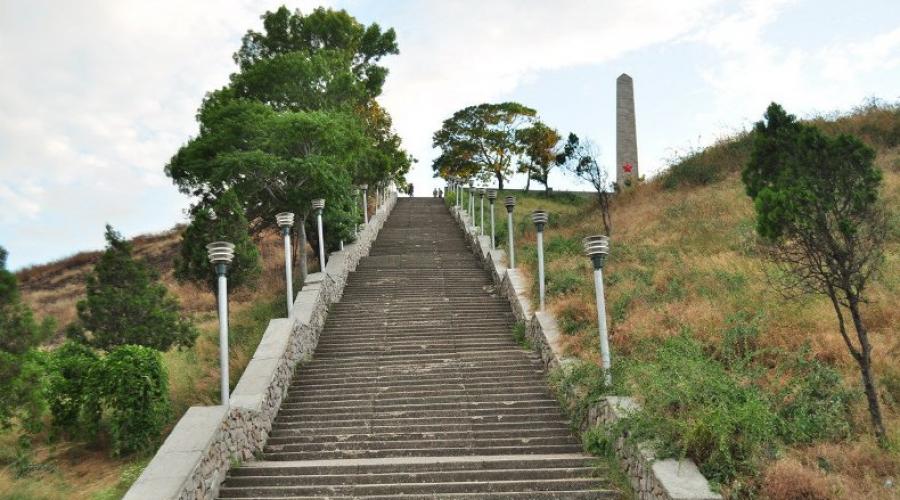
Mount Mitridat
Mount Mridat in Kerch rises above the Kerch Strait. Not very high, just over 90 meters, for those who will master the rise in a large Mithridate staircase, decorated with sculptural images of Griffins, the mountain will give a stunning view of the strait and surroundings of the city.
Here was the so-called first chair of Mithridate (now there is an eternal flame on this place) and he looked at the Great Tsar Mithridat VI Evpator from here. All his long life spent in continuous wars, constantly conflicting with Rome, who managed to turn, alike for a short time, the Black Sea in the inner sea of \u200b\u200bhis Bosporian kingdom, he finished his rigorous life path here, in the ancient city of Panticapey.
Excursions and holidaymakers are usually indignant by the betrayal of his son Farnaka, but the subjects of Mithridate are simply tired of him hard to explain the love of the endless war with the eternal city, the army rebelled and under the threat to be captured the king himself asks for a friend to deprive him of life. Yes, and he himself treated his family peculiar - the first wife of KazNIL, one of the sons brought to suicide.
Many holidaymakers worries the story of allegedly hidden in the dungeons of the palace of the legendary king of indiscreet treasures. Yes, King Mithridat robbed a lot and in the "partners" he had Cilician pirates, but no one had found treasures. Many still stored Mount Mridat in Kerch.
Glorifies the feat of Soviet soldiers who liberated the city during fierce fighting in April 1944, Obelisk Glory. The fights for Kerch were so heavy and so difficult was given to this victory that during the operation to liberate Kerch from artillery shelling suffered many monuments, including mausoleum Stembkovsky, the city holder of the city and the famous archaeologist and writer.
 Mount Mitridat - Photo 02
If you are on excursions to Kerch, be sure to find strength and time to climb the mountain Mithridate, and those tourists who choose Kerch the place of their holidays, climb the mountain will often. Indeed, among Kerch attractions, Mount Mitridat occupies a special place.
Church of John the Forerunner
Kerch's attractions include one of the most ancient Orthodox churches in the Peninsula - Church John the Forerunner. Located the Temple of John the Forerunner in Kerch on the Tavrichesky Square, not far from the descent from Mount Mridat. Temples with such architecture were usually erected in Byzantium and in Armenia. In those distant times, when the Temple of John the Forerunner was built in Kerch, and this happened no later than the IX-X century, he was at the shore of the sea and had a kind of unusual and memorable. White-pink masonry, often occurring among the Byzantine buildings of that era, in addition to the decorative task, solved the task of strengthening the seismic strength of the structure.
 Church of John Forerunner - Photo 03
With the victory of Ottomans over Byzantium and the appearance of Khanate in Crimea, the Temple of John the Forerunners turned into a mosque. It lasted until the inclusion of Kerch into the Russian Empire, when the temple was again Orthodox. In Soviet times, the temple survived the long year of oblivion and launch. Now the temple of John the Forerunner in Kerch is the acting Orthodox church. This is the only preserved ancient Orthodox Church in the Northern Black Sea region.
Be sure to visit it and admire the flat dome resting on the cross-shaped arches, on the marble columns with the capitals in the Byzantine-Corinthian style, which the temple inherited from even more ancient and not survived to the church.
Turkish ENI Kale Fortress
Popularity is popular among the attractions of Kerch Yeni-Calea, erected in recent years of Turkish domination over the peninsula. By his appearance, the fortress is obliged to be very unexpected for the Turk "Visit" of Tsar Peter to the area of \u200b\u200bthe Kerch Strait on the ship "Fortress". Turks respond to this audacity of Peter Alekseevich the construction of the fortress, which should have protected the strait. It was an outstanding fortification for that time built with the help of French engineers.
 Fortress Yeni-Kale - Photo 04
In the fortress there was a powerful garrison and a residence of Pasha. The adjacent water areas of both seas ran out of the fortress. An unusual form of a fortress with protruding semins. According to the creators, the fortress could withstand a long siege. But she fell without a single shot, the garrison was simply afraid of the opposing Russian army. You can get to this curious attractions on the route taxi 18 and 24.
Museum of Eltigenous Designa
In the village of heroevka, which is 16 kilometers from Kerch, there is a museum that should be visited by all. it museum of Eltigenous DesignaHaving made a special place among Kerch attractions. 10 days lasted in November 1943, an arguing operation is unusually boldly, during which the paratroopers held for 3 days held Mithridate.
The very fact that 60 people from among the participants of the landing have earned the title of Hero of the Soviet Union. And just landed ashore near the heroes about 5 thousand paratroopers. By visiting the paratroopers memorial, which is part of the Kerch museums, you will see the motobot, and a field hospital, and the brotherly grave of the member of the landing.
 Museum of Eltigen Assant - Photo 05
Museums Kerch
All Kerch museums are united in Kerch historical and cultural reserve. Kerch's museums come historical and architectural museumFamous lapidariumalready named museum of Eltigenous Designa, Champs and Tsarsky Kurgan, fortress Kerch, picture gallery.
Ancient settlement Mirmekiy
Another among the attractions of Kerchi - mirmeki settlement. Antique authors mention Mirmekiy among other cities on the east coast of Crimea, such as Panticapey and Feodosia. Although Strabo allows itself to be not very respectful to call the Mirmeki village. However, the results of archaeological excavations such an assessment of the famous geographer deny. Marble sarcophages and remnants of defensive walls at the scene of simple villages are not found, and they found here.
Found Mirmeki Greeks, this is an ionic settlement. Residents were engaged in fishing and agriculture, later began to engage in winemaking. Mirmekiy his inhabitants were thrown due to invasion is ready at the beginning of our era.
 Mirmeki settlement - photo 06
By the way, stay is ready on the territory of Crimea Hitler considered proof that it is "invalid" the German Earth. It seems that the residents of Mirmekia would have agreed with this judgment.
Beaches Kerchi
What is the southern seaside resort town without resting on the beaches?! Beaches can be safely attributed to the sights of Kerch. Vacationers can choose between the beach " Capps», Youth, wild beach near the fortress Kerch, ARSHTITE SPOSE (this is an urban beach), General beaches. There is from what to choose. Read more about the beaches.
 Youth Beach - Photo 07
In conclusion, I must say that this note managed to tell far from all the Kerch sights. In this oldest of the cities preserved in our country, you can spend a wonderful vacation, combining beach pleasures with the most interesting excursions.
Kerch is a unique city. He stands in the very place where the water of the two seas are found - no wonder before our era literally occupied immigrants from Ellala, building several colonies here. It is a pity that only ruins remain from the ancient Pantikapey, Mimmekia and Nymphi, but these ancient stones remember dozens of past centuries.
In Kerch, an incredible number of attractions of different periods are simply an incredible number of different periods: the tomb of the Bosporian kings, an exceptional and some kind of miracle the preserved temple of the VIII century, the Turkic fortress and architectural monuments of the period of the Russian Empire. Local sandy beaches are an excellent alternative to the rocky bays of the southern coast of Crimea. Some of the bathing areas even seem more comfortable and adapted for a comfortable stay.
Best hotels at affordable prices.
from 500 rubles / day
What to see and where to go to Kerch?
The most interesting and beautiful places for walking. Photos and a brief description.
Since 2014, ferry crossing, perhaps, the only way to get from mainland Russia to the Crimea. The transport hub functions clearly and coolerly, although in a high season you can wait in the queue for several hours. During a short 20-minute trip from one shore to another, you can admire the waves, flocks of tea, soaring near the vessel in anticipation of food, and even, if you are lucky, see the Athlegne style.
The low 90-meter hill in the city feature, the Geographical Center of Kerch, where the city of Panticapey was in the ancient times. The place is named after the Pontic Tsar. Within the mountains of the mountain there are several architectural monuments of different times. At the top there is a memorial of glory to immortal heroes, erected in honor of the fighters who fell during the liberation of the Crimea in 1943-44.

Initially, the staircase was built in the XIX century on the project of the Italian architect A. Digby. She existed to the Crimean War, but as a result, the fighting was damaged and destroyed. Recovery took up only in 130 years. The Kerch sculptor R. V. Serdyuk copied the ancient statues of Griffins found on the excavations, and decorated with the staircase spans. After the collapse of the part of the structure in 2015, regular restoration work started.

Ottoman stronghold of the XVIII century, built by the architect of Italian origin, former in the service of the Turk. This bastion had a strategic importance, since he prevented the passage of enemy ships along the narrow strait between the Black and Azov seas. In 1771, Russian troops entered the fortress. By the end of the XIX century, she lost her military importance and was abandoned. At the moment, the attraction continues to collapse.

Strengthening is in the narrowest part of the Kerch Strait at Cape Ak-Burun. The complex was erected in the middle of the XIX century for the defense of the borders of the Russian Empire. In Soviet times, the Armory Warehouses of the Black Sea Fleet was located here. In 2003, after disbanding military units, the fortress was submitted to the local Museum-Reserve. Nowadays, it functions as a tourist object.

The Rannesseed Orthodox Church of the VIII century (his oldest part was erected in the VI century), a unique monument of the Byzantine architecture and the oldest religious construction in the Crimea. The final appearance of the construction acquired in the X century during the existence of the Tmutarakan principality. The church is a valid, inside there are modern iconostasis and utensils.

Ancient Greek colony, which existed in place of Kerch from the VII century to our era. In those distant times, there were magnificent temples, and the streets and wide areas were full of people. Later, PantikaPay was part of the Bosporian kingdom, was under the Scythian and Roman Protectorate. The rich city was destroyed by Goths in the IV century, time tried the work - today only ruins have been preserved from the former magnificence.

Antique tomb with preserved residues of original frescoes. Currently, it is located in the midst of urban development, in antiquity was located on the territory of Pantikapey. The crypt is a rectangular structure with walls of stone blocks. A small corridor leads to the mortgage chamber. Given the solid age of the wall painting, it preserved quite well.

The complex of artificial caves, which formed as a result of the centuries-old shell production. The place is famous for the fact that in 1942 they kept the defense of the troops of the Crimean Front. In 1966, the Museum of Defense Adzhimushki Kamenomine was organized on the territory of the Underground Mins, in 1982, a memorial in honor of the deceased warriors was erected. The entrance to the territory is among the stone plates with the defender figures cut on them.

Monument to the IV century BC, which is a tomb of one of the rulers of the Bosporian kingdom. Kurgan embankment towers at 17 meters above the surface, under it there are 36-meter corridor and the burial chamber, laid out by smooth blocks. The hill itself consists of three layers: stone, clay, a mixture of pebbles and land. When archaeologists got to Kurgan, he was already looted.

Another tomb of the IV century to our era, excavated in the middle of the XIX century. During the works, archaeologists hoped that Kurgan was left inviolable and retained all his treasures, but they were mistaken - he was also empty as royal. Local residents admitted to export from here clay for household needs, but thanks to the landmarks allocated from the State Cassente, the attraction managed to save. The first museum has opened here in 1871.

The museum was founded in 1926, which makes it one of the oldest in the Crimea. During the Crimean war, the building was destroyed, and the exposition was plundered, some particularly valuable items were taken to England, so now the exhibits of that time can be seen in the British Museum. Later, the collection began to collect anew, and the museum was allocated a new building. To date, more than 240 thousand copies are stored in its funds.

The lapidarium is called the collection of art objects of an antique era found on the excavations of the settlements of the era of the Bosporian Kingdom. Here are the sculptures, testers, elements of facade structures, containing inscriptions and bas-reliefs, worship items and much more. The exposition is so diverse that it is estimated to be valued all over the world. In total, about 6 thousand items are located in Lapidaria.

The building of the art gallery is located near a large Mithridat staircase and is part of its architectural ensemble. The construction is built in a classic style. The basis of the collection is the founder of the founder of the museum - artist N. Ya. Buta, and specifically the cycle "Agimushki. 1942. " In addition to paintings, other exhibits are exhibited in the gallery: sculpture, ceramics, glass products and other art objects.

In 1943, the village of Eltigen, the Soviet paratroopers of 40 days were fighting with the German army, showing depth courage. With these events, the liberation of the Crimea from the occupiers began. At the place of landing the landing, a museum was built, in which the things of fighters, weapons and awards are exhibited, and a memorial complex has been erected, which includes the fraternal grave, monument, the remains of the trenches and the boat on the pedestal.

Mirmekiy - Colony of Ionian Greeks, based on the shores of the Kerch Strait in the VI century BC. She existed until the X century, in the Middle Ages, new settlements began to appear in his place, because of which the ancient cultural layer was immersed under the ground. The first finds on the territory of Mirmekia were made in the 1830s, but regular excavations began in the XX century. Nowadays, there is an archaeological complex.

Another settlement of the ancient era that has come down to this day in the ruins. It is on a high plateau in an urban feature. The settlement existed to the VIII century, after which it was destroyed during the Turkic raids. Permanent excavations were carried out at this place since the 1920s. As a result, the foundations of houses were raised on the surface, the remains of the stamped area and streets.

The ruins of an ancient Greek city, located approximately 17 km from Kerch. Given the number of antique colonies in the city itself and its surroundings, you might think that it was even more prestigious to settle in Tavrick than in Greece itself. It is a pity that none of the cities of the era located in the Crimea did not reach this day. Nymphy is the same ruins as Mirmekiy, Tiritaka and Panticapy.

Approximately 8 km from Kerch on the territory of the shallow basin there is a unique natural attraction - mud volcanoes. These are small lakes from a mixture of a brown-gray earth and water having a thick consistency. In each puddle there are crater, from which gas bubbles are broken from time to time. Sometimes the volcano throws a rather powerful mud fountain with a jet height of up to 20 meters.

To have your own ostrich farm considers almost every seaside resort. It did not fall behind and Kerch - a pair of kilometers from the crossing in the village of Submock since 2004, they also dilute these exotic feathers. Birds were quite quickly acclimatized and numerous offspring almost immediately began to give. Later, they were joined by peacocks, pheasants, lamas, donkeys, pons and other animals.

Salted lake located near the village of Resort 16 km from Kerch. Until 1917, there was a mudhouse for him, until the 1940s salt were mined here. The reservoir is separated from the sea with a small strip of sushi, along which the strip of sandy beaches runs. With a certain lighting, the surface of the lake acquires a pinkish shade, which looks very picturesque on the background of the surrounding steppe.

Cape is the northern tip of the Kerch Peninsula. Even before our era, these edges were settled - the Greek settlement was located here (in Kerch and the surrounding area, apparently, it is easier to find a place where there was no ancient colonies). Cape performs in the Azov Sea and is the natural border of two bays: reefs and marines. The place is quite picturesque and deserted, perfectly suitable for the contemplation of marine spaces.

Cape is located on the eastern outskirts of Kerch at the entrance to the Strait. Very comfortable position for the lighthouse, which was here for the first time in 1820. In the area of \u200b\u200bthe lantern, seagulls live, cormorants and water courses. The Yenikal Lighthouse, restored after the Second World War in the 1950s, and today is valid. Although the tower looks slightly outdated, it is equipped with modern equipment.

Surrounded by cliffs picturesque bays, stretching along the coast of the Azov Sea. They still preserved pristine beauty, so tourists seeking privacy and tired of promoted resorts come here. Behind the wide sandy strip stretch the endless landscapes of the "Pontic" steppe, the coastline is cut by dozens of small bays, there is no hint of civilization around - what else is needed for happiness?

Kerch's main beach is the most comfortable room for swimming in the city. It is located on the reed-Buran spit and has access to the embankment. Main advantages: Hollow bottom, sand coating and small shell, presence of locker rooms, arbors, cafes, sun loungers and car parking. Vacationers offer many water attractions and other entertainment.

Do we often think about those places where we live? Local history data on native places is extremely rarely necessary in everyday life. And the information about the region most often we only get in the lessons of environmental education still at school. The Kerch peninsula is a large enough and an interesting edge. And, you can learn a lot new. The Kerch peninsula certainly does not compare with rest in Sanya, but still has a number of advantages.
From the rest of the Crimea, the peninsula is separated by a small Akmonai Cleans. The most narrow point of the cower in width is 17 kilometers away - from the southern tip of the Arabat arrow to the village of Primorsky (on theodosi bay). In the time of antiquity, the border of the Bosporian kingdom was located here, and today - Leninsky district. The maximum width of the Kerch Peninsula is 52 kilometers: from Cape Kazantip on the Azov Sea to Cape Chaud - on Black. From the west to East, the Kerch peninsula stretched over more than 90 kilometers. The total area of \u200b\u200bthe peninsula is 2830 km2, and this constitutes a little more than 10% of the territory of the whole Crimea.
On the Kerch Peninsula, two types of relief are distinguished: in the south-west - a wavy lowland plain with a bias to the sea, in the north and northeast - low mountains and limestone ridges.
Southwest is the edge of earthland. From the village of Vladislavovka to Martvik, a mountain range was stretched, named parpachi. In the south, he smoothly descends to the mountain of the opon - one of the highest peaks of the peninsula (height - 185 meters). The Opunk Natural Reserve was organized here. Under his defense there are pink starlings that will not be nesting anymore in any corner of Ukraine.
From the parpach ridge towards Kerch stretch low mountains up to 150-180 meters high, there are beams and valleys of rivers. Mitridatovsky comb with the highest point of the Kerch Peninsula - Mount PihBop (189 meters) towers near Kerch.
One of the distinguishing features of the Kerch Peninsula from the rest of the Crimea is the presence. Some have long been inactive volcanoes, turned into insulated hills or hills. During rainy days, they turn into "Kolya" - Fast lakes.
An unfavorable natural conditions for the development of forest vegetation have developed on the peninsula. In the 50s, no far from Cape Kazantip artificially created a forest plant, which in 1962 was transformed into leshozaag. Here planted Crimean pine, maple, bark, ash, acacia, elm, almond, rosehip, silver sucker. Today, forests at the Kerch Peninsula occupy an area of \u200b\u200b7 thousand hectares. Successful experiments with forests on sandy soils turned out to be freshwater thanks to the shallow location.
Another artificial forest was laid near the village. The founder of this leshoza was the first secretary of the district party of the party N.I. Parelsky. In the early years after the Second World War, the local places were a dusty steppe, fresh water was taken from the Ousul station (today the village remained). At first they built dams, and bushes and trees were planted around the received bets. Pellary even brought frogs to these rates. Today, these forest plantations are elevated to the status of the state reserve of local importance.
The climate of the Kerch Peninsula is arid, so a lot of water resources here. The lack of precipitation on the territory made the river system of the peninsula just a branched beam system. However, on archaeological studies, with ancient times, these places were tightly populated. Consequently, the rivers were once broken. And the presence of fresh water has always been one of the main conditions for the settlement of new territories. Geomorphological studies show that the valleys of the local beams were river river channels, there are also inappropriate terraces.
Previously, the Kerch Peninsula contains bison, tour, saiga, wild horse, donkey, Jaran. In 2-1 millennia BC, the climate of these places has become sheer, many rivers of the rivers or dry. The minority of the rivers and beams of the Kerch Peninsula could not contribute a large contribution to the development of the national economy, so they did not take deeply for their study. Today, the rivers and beams of the peninsula are the most unexplored. In 1925, the Expedition on the beams held Botanic E.V. Kulf and researcher I.I. Pozhanov. They have data on the abundance of wells, but at the same time, water is suitable for drinking only in one of them. In the rest, "and the toad will die", which means an increased salinity of water.
Such wells in those times were the only sources of water of the peninsula, and they were not enough to meet the needs for fresh water. Today, this question solves Dniprovskaya water, which in the North-Crimean Canal fills seven reservoirs, a total of 97 million m3. The largest rivers and beams of the Kerch Peninsula begin with a parpach ridge and carry water to the north, south and east. One of the most branched networks is located in the north and northeast of the peninsula.
The Kerch peninsula on three sides is washed by the waters of the Azov and Black Seas. The Western border passes through the Akmonai Ist. Area - about 3060 km 2.
The nature of the Kerch Peninsula is extremely original and diverse. Here are landscape complexes of meago-solankane and hollow semi-deserts characteristic of the pride of deanudament and remaining steppe plains similar. Crimean foothill and Tarkhankut Peninsula. Warm smoking winter of the coast of the Feodosiy Gulf and significant participation in the vegetation of Mediterranean species in the vegetation of Mediterranean species brings him closer with the southern coast of Crimea, doping folds and mud vulcanism relatives with the Taman Peninsula.
At the base of the peninsula, oligocene and lower-stage dark shale clay (Maykop series) are locked. These clays come to the surface in the southwestern part and in the blurred anticline nuclei. In the northern, northeastern and eastern part of the Kerch Peninsula, Maykop clays are blocked by medium-solenia and uppercase (sarmatical) sediments presented by clays, sands, merges and limestones. In the synclinals of the central and eastern part of the Kerch Peninsula, as well as in some
anticlinal hollows Sarmatian sediments are blocked by the breeds of the meticuliac, Pliocene and anthropogen age.
Tectonic structures of the Kerch Peninsula are characterized by fragility. Characteristic is the alternation of anticline structures formed by the system of brachianticinal folds and syncinal defickers (Murd).
According to M. V. Muratova (1960), the formation of anticline folds began even to medium minezen and continued until the end of the Pliocene. At the same time, their destruction was influenced by the abrasion and erosion-denudation processes. The central parts of them, composed by Maykop clays, were destroyed; Apoldered anticline brand and ring resistant hills for the Kerch Peninsula. In the formation of the south-western plain of the peninsula, maritime abrasion played a decisive role.
The anthropogen period in the development of the relief of the peninsula is characterized by a repeated change in the direction of its development due to non-systemic movements and a change in the sea level. It was dominated by accumulative processes, when lesident loams and clays were accumulated, denantation processes were developed, which, however, did not differ in large intensity due to the small depth of local commodities of erosion and climate dry. Currently, the peninsula is characterized by abrasion-denudation, abrasion-denudation and remains and accumulative plains.
The climate of the Kerch Peninsula is arid with relatively soft winter. Winter is relatively stable. The temperature period below zero ranges from 33 days south-west to 60 days in the northeast. In the same direction, the average temperature of the coldest month of February from -0.2 to -1.7 ° is changing.
The frosts occur annually to -15 °, and occasionally and up to -30 °. Spring is relatively late and cold. Summer roast and dry. Armored period ranges from 220-225 days on the coast of the Azov and Black Seas to 200 days in the center of the peninsula. The temperature with a temperature above 10 ° changes in small limits from 187 days in the center and in the North-East to 191-193 days on the south-west coast. Dangerous frosts for farm crops rarely happen. Precipitation falls small - from 253-300 mM.on the southern and northern coast d 0 400-438 mM., in the center and on the eastern outskirts of the peninsula. About 60% of precipitation falls in the warm period of the year.
The hydrographic network of the peninsula is represented by dry and beams. The largest chubby Somarli, the width of his valley with a well-pronounced first pearly terrace reaches one kilometer.
Maximum stock - 50 m 3 / s.,but in the summer river, like other watercourses, dries. The largest lakes of the peninsula - Aktshchskoye, Chokrakskoye, Churubash, Tobychskoe, Opukskoye and Uzunlaskoe - are located along the coast of the sea and have lagoon marine origins.
Groundwater spare at different depths. In the area of \u200b\u200bthe lakes, the sea coast and in the basins, groundwater spawn at a depth of 0.5 to 3 m,on watersheds at a depth of 10 or more. Most of the groundwater is sleeping both at the expense of sea water (on the seaside of the sea and lagoon lakes) and by dissolving salts from Sarmat and Maykop solenous clays.
The soil cover of the peninsula is characterized by a large varnish and is formed by the combination of southern black soils, brown stralywed soils, solontsies and salt marshes.
The distribution of soil differences, the degree of salinization, the power of the soil horizon is mainly determined by the height above sea level and the character of the soil-forming rocks. The richest black earth and dark chestnut soils were formed on the lesidal clays in the synclinal hollows and on limestone-deluvial sediments in anticline facilities.
The zonal type of vegetable cover on the peninsula is the Kampie-Ticker and Ticker-Walking Steppes. From other types of vegetation, mesophytic and halophyte heats, hint-solankane semi-deserts and petrophite steppes are widespread.
Pavement of about 32% of the area. 25% of land suitable in agriculture, the rest of the area is used under the hay and pastures.
For the Kerch Peninsula, landscape differentiation is characterized, which manifests itself together with other factors determines its landscape structure.
Abrasion-denudation-remaining steppe areas occupy a relatively small area (21.5%), but they attach unique features of nature to the entire Peninsula. There are three types of remains - ring, gonomous and watershed dome. All of them are composed of relatively solid rocks, mostly limestone.
For the described types of terrain, the predominance of slope tracts is characteristic. The greatest propagation has a gentle slopes of a steepness from 1 to 10 ° (84%), the slopes of the average steepness from 10 to 24%, and the rocks and steep slopes (steeper 20 °) are only 1%.
At the steep slopes of the soil, black-chicken-carbonate rocky-crushed stone, on gentle - more powerful. In the vegetation cover, the shrub-divergent steppes dominate. Among
shrubs have a hawthorn, rosehip and a turn. Steep and medium steepness slopes of this type of terrain can be used under forest plantations that are well managed here. On gentle slopes can
Place gardens and haymaking. Significant areas of these slopes with
more powerful soils with strict observance of anti-erosion
events can be docile under arable land with grain and stern
crop rotations and strict compliance with anti-erosion events. The abrasion-deduction-remaining welcoming-taper-petroofite-steppe type of terrain is distributed mainly in the central part of the peninsula. It is characterized by greater stonyness, it is characterized by a petroofite steppery in low-power crub-bright soils, welcoming-ticker steppes and less frequently of the coal-diverse steppes. In the farm, it is used mainly under the grazing. Improving its economic value will require a radios.
Denudament-plain cooper-ticker-steppe type is one of the dominant on the peninsula (22.5%), however, the economic value of its value is small, as low-power, often gravel or medium and fatty soils are common here. The best of these are weak-tested carbonate black soils and dark brown soils, formed on the limestone deluvia, with good processing give high grain, sunflower crops and other crops.
The abrasion-denudation-plain type of terrain was developed in the north of the south-western plain and in anticlinal basins, where the groundwater is relatively deep.
Dark brown medium and low-roll soils in a complex with salty chernozem, formed on the delustivity of Solenoste Sarmatian and Maykop clays, are distinguished by a heavy mechanical composition and a dust structure. In the wet years, subject to agrotechnical processing rules, there are good grain crops on these soils.
Among the denudation-plain and abrasion-deduction and rhinestate localities, a tract is located, the characteristic of the rinkerchensky peninsula - mud volcanoes. They are expressed by orcholls of a cone-shaped form, or a cloak of a mud-labeled material, which only slightly towers over the surrounding plain. In agricultural terms, they are not used and belong to uncomfortable lands.
The accumulative-plain coil-ticker-steppe type of terrain is timed to the synclinal hollows, it occupies a relatively small area (16.9%), but is the main resident of the peninsula. These plains are composed of powerful thick carbonate loam and lumbering clay. The soil of the type of southern black soils is usually dense addition, contain up to 3-4% humus, relatively provided with movable forms of phosphorus and nitrogen and in fertility are not inferior to the same soils of the steppe Crimea. The accumulative plains in the past were occupied by typical woven steppes. Now most of them are rapping. This type of terrain is located at the heights of 40-100 m.and convenient for irrigation. With the North-Kpim Canal, the main arrays of irrigated land will be located here.
A weaker meadow-solicky type of terrain is distributed in the southwest and on lowland coasts in the area of \u200b\u200bthe Lagged Lake of the Kerch Peninsula. For this type of terrain are characterized by heartless depressions - " if"Water filling in the spring and drying in summer, the depressions of permanent mainland salted lakes attached low-lying sites and the mouth of wide beams. All soils are sleeping here, solonts are widespread in a complex with salt marshes. Vegetation is represented by various types of halophyte meadows from a crawled, wormwood of Solonchakova, Kermek, a fire, immorter, swinewood, becmania and other species. The most moistened places on the banks of the Kazantipsky and Feodosian bays are occupied by reed, sitney and rogo swakes Most of the described area of \u200b\u200bthe terrain is used as Pasture Loupe.
The meadow-beam type of terrain is common everywhere, although it takes only 8.9% of the area. It is characterized by a tract of beams and tender. Beams play a big role as natural drainage, for which flood water is removed and wash
salt icons. Brushores, unlike beams, have a well-pronounced understanding of the leakage terrace. Width of the valley fluctuates from 200 to 1000 m.Good moisturizing, powerful meadow cryoous soils provide the development of clover-boilers, pylaino-becmanium and pylaino-divergent meadows, with harvest until 20 c / gvaluable in herbs feed. Separate sections of these valleys can be used under the gardens and gardens.
According to the nature of the geological and geomorphological structure and the landscape structure of the Kerch Peninsula is divided into two physical and geographic areas - southwest District of Structural Erosion Plainand the northeastern district of the Grocery-Uvalid erosion-denudation plain.The border between them passes through the limestone parpachsky ridge (Fig. 18).
In conclusion, it should be noted that the lands of the Kerch Peninsula are poorly used in agriculture. There are only 32% of the area of \u200b\u200bthe area. Conducting the North-Crimean Canal to involve significant land arrays into an intense agricultural turnover and bring the territory's deposit to 50-60%. Here they are well affected by the early and secondary grape varieties, many garden crops, including apricots, cherries and apples. Good yields give grain crops: Wheat wheat, spring and winter barley. Along with this, significant areas should be diverted under the forest and forest windproof and anti-erosion forest stripes. Modern density of forest bands does not exceed 1% of the area and is clearly insufficient. And planted two large arrays of forest develop well.
568
Section IV.
Ukrainian Carpathians