Presentation on the topic of the Urals. Presentation on the topic "natural region - the Urals" Presentation on the topic geographical location of the Urals
8th grade was completed by Kolegova L.V. geography teacher s. Bolshoi Bukor, Chaikovsky district, Perm region, Urals
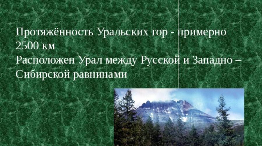
At the junction of two parts of the world, Europe and Asia, the largest lithospheric plates, the largest river basins.
A continuation of the Ural Mountains in the north are the islands of Novaya Zemlya and Vaygach, and in the south are the Mugodzharsky Mountains
1 . This is a single mountain system created during the Hercynian folded era. The main features are:
2. The barrier position in relation to the westerly winds enhances cyclonic activity in the west and creates sharp differences between the western and eastern slopes.
3. Shift of the boundaries of landscape belts in the mountains to the south relative to their boundaries on the plains.
Stages of the origin of the Ural Mountains. Stage 1. Archean and Proterozoic era. Stage 2. Palaeozoic. (Hercynian folding) Stage 3. Mesozoic era. Stage 4. Cenozoic era. + + + +
Latitudinal profile of the Urals. Russian Plain Main (watershed) ridge 1200 1800 1600 Western foothills Eastern foothills West Siberian Plain The Ural Mountains are asymmetrical: the western slope is gentle, the eastern slope is quite steep.
Minerals The placement of minerals is related to the geological structure. In the western foothills, in a tectonic trough dominated by sedimentary rocks, there are minerals of sedimentary origin: potassium salts, table salts, limestones and marbles, refractory clays, sands, coals and sulfur pyrites. There are oil and gas reserves in the Urals. salt mining potash salt coal
In the Northern Urals there are bauxites. The main wealth of the Urals is the ores of ferrous and non-ferrous (copper, nickel) metals. igneous rocks In the eastern foothills and Trans-Urals, composed of igneous rocks, ore deposits (iron, copper and manganese ores) copper have been discovered
The Urals are also rich in precious metals (gold, platinum, silver), precious, semi-precious, and also ornamental stones. platinum gold silver
Differences in the climate of the northern and southern regions Climate change with altitude Differences in the climate of the western and eastern macroslopes. climate
Western slope. The weather is softened by warm Atlantic air. More precipitation falls. In the northern part of the Cis-Urals spruce and broad-leaved-spruce forests grow, in the south there are forest-steppe and steppe. Climate: moderate continental
Eastern slope Continental climate Zone of influence of cold Siberian air Larch and small-leaved forests dominate in the Trans-Urals
In the Urals there are the Pechora-Ilychsky biosphere and 10 more reserves (Vishersky, Denezhkin Kamen, Basegi, Visimsky, Ilmensky, etc.) and 5 national parks. Protected places Attractions
No. 6. Pechoro-Ilychsky reserve. Founded in 1930 Here you can find oddly shaped remains. No. 7. Mount Denezhkin Stone No. 10. Reserve "Denezhkin Stone" No. 8. Mount Konzhakovsky Stone No. 9. Vishera Reserve. Northern Urals
Here is the large Kaninskaya Cave (63m) - it served as a place of sacrifice for local residents from ancient times until the beginning of the 19th century. The world's northernmost Paleolithic site of a man who lived here 20,000-25,000 years ago was found in the Bear Cave. A large number of bones of extinct animals, such as the cave bear and the tiger lion, were also discovered. Northern Urals
The only mineralogical reserve in the world. They call it the richest pantry of the Ural Mountains. Ancient mines (400) have been preserved here, in which you can see “outlandish pebbles” from the tales of P.P. Bazhov Southern Urals Ilmensky Reserve The pride of the reserve is ilmenite, a black mineral with a semi-metallic sheen; in 2005 it became known that an ilmenite deposit exists in Moon. In total, 270 minerals were discovered in Ilmeny, of which 17 were discovered for the first time. There are rare and rare ones here, not found anywhere else in the world
Southern Urals Kapova Cave Cave with wall images of the Paleolithic era on the Belaya River.
Test: Complete the sentence. The Urals stretches for more than ... kilometers from the coast ... of the sea to the steppes.... The chains of the Ural Mountains form the border between the region of temperate continental and... climate, between the Volga basin and..., between the Russian Plain and..., between the ancient platform and.... 2 . In terms of height, the Urals are classified as mountains: a) low b) medium c) high; 3. According to their structure, the Ural Mountains are classified as: a) folded b) folded-block c) block. 4. Choose the correct statements. a) The share of glaciers in feeding the Ural rivers is very significant. b) The main wealth of the Urals is forest resources. c) The Urals are a natural boundary between the Russian and West Siberian plains. d) More precipitation falls on the western slopes of the Ural Mountains than on the eastern ones
5. Indicate the part of the Urals that has the greatest absolute height: a) Polar Urals; b) Subpolar Urals; c) Northern Urals; d) Middle Urals e) Southern Urals 6. Indicate the absolute height of the highest point of the Ural Mountains - Mount Narodnaya: a) 5642 m; b)8848 m; c) 1895 m; d) 2922 m. 7. Select the characteristic features of the Subpolar Urals: a) parallel arrangement of ridges; b) the highest altitudes in the Urals; c) strong earthquakes; d) distinct traces of ancient glaciations.
7. Identify the numbers that indicate in the figure: a) Mount Yamantau; b) the Pechora River; c) the Ural River d) Pechora-Ilychsky Nature Reserve; e) Pai-Khoi ridge; f) Southern Urals; g) Northern Urals; h) Subpolar Urals. i) Mount Narodnaya; j) Chusovaya River; k) Ilmensky Nature Reserve; m) Mount Konzhakovsky Stone; Answers: a2, b4, c10, d6, d15, e13, h7, i1, k8, l11, m3.
The Ural economic region includes: Kurgan, Orenburg, Perm, Sverdlovsk, Chelyabinsk regions, as well as the republics of Bashkortostan and Udmurtia. The basis of the region is made up of medium-high ridges and ridges, only a few peaks reach an altitude of 1500 m above sea level. The highest peak is Mount Narodnaya (1895 m). Mountain ranges stretch

parallel to each other in the meridian direction, the ridges are separated by longitudinal mountain depressions along which rivers flow. Only one main chain of mountains is almost uninterrupted by river valleys; it forms a watershed between the rivers flowing to the Russian and West Siberian plains. The Urals are strongly elongated from north to south, so the country’s most important latitudinal communications pass through it
The Ural region is located between the old industrial regions of the European part of Russia, Siberia and Kazakhstan - at the junction of the European and Asian parts of the Russian Federation. This “neighborly” position can be assessed as favorable for the functioning and development of the entire economic complex.
The territory of the district, due to its internal position between the western and eastern economic zones, which have different levels of economic development and different specializations, ensures transit connections between them.
Population of the Urals
The region is home to 20.4 million people. The average population density is 25 people/km, but in the southern and especially northern regions it decreases sharply (to 1 person/km and lower). The population of the Urals has grown somewhat in recent years due to Russian immigrants from Central Asia and Kazakhstan, but in the future it will decline, since the natural growth in the area is negative (-5). The Urals are characterized by a high level of urbanization, the concentration of the majority of the population in large cities, which is largely explained by the predominance of large enterprises in the industry of the Urals.
Natural resources
The complex geological structure of the Urals determined the exceptional wealth and diversity of its resources, and the long-term processes of destruction of the Ural mountain system exposed these riches and made them more accessible for exploitation.
The natural resources of the Urals are very diverse and have a huge impact on its level of development. The Ural region has mineral resources, fuel, and non-metallic minerals. In terms of reserves of some types of mineral resources, the Urals ranks first in the world (copper ores, asbestos, potassium salts).
The fuel resources of the Urals are represented by all main types: oil, natural gas, coal, oil shale, peat. Oil deposits are concentrated mainly in Bashkortostan, the Perm and Orenburg regions and in Udmurtia, natural gas - in the Orenburg gas condensate field, which is the largest in the European part of the country.
Deposits of iron ores and non-ferrous metal ores are concentrated mainly within the Ural Mountains. More than 2 thousand deposits and ore occurrences of iron ore are known in the Urals.
The forest resources of the region are significant. The Urals are part of the multi-forest zone of the country; in terms of forest cover, it is second only to Siberia, the Far East and the North of the European part of the country. The main part of forest resources is located in the northern part of the Ural economic region - in the Sverdlovsk and Perm regions.
Transport of the Urals
Transport plays a huge role in the functioning of the economic complex of the Urals. This is explained, on the one hand, by the region’s active participation in the territorial division of labor, and on the other, by the high level of complexity of the Ural economy, which is manifested in the fact that many sectors of the economy do not work in isolation, but in close interconnection with each other. Hence the high share of intra-district transportation
Mechanical engineering in the Urals is a large branch of its market specialization and occupies a leading place in the structure of industrial production of the Ural economic region. Currently, there are almost 150 mechanical engineering enterprises operating in the region, representing all sub-sectors of mechanical engineering. The following industries are developed here: heavy engineering (production of mining and metallurgical equipment, chemical and petrochemical equipment), energy (production of turbines, steam boilers and others), transport, agricultural engineering, tractor manufacturing. Electrical engineering, instrument making, and machine tool manufacturing are developing most rapidly.
The chemical industry, a branch of market specialization in the Urals, has a powerful raw material base, using oil, associated petroleum gases, coal, salts, sulfur pyrites, waste from ferrous and non-ferrous metallurgy, and the forestry industry. The Ural economic region is one of the leading regions in the country in the development of the chemical industry, which is represented here by all the most important industries: mineral fertilizers, synthetic resins and plastics, synthetic rubber, soda, sulfuric acid and others.
The Urals is also a major consumer of chemical industry products. Of greatest importance is the production of mineral fertilizers, among which potassium fertilizers stand out. Potash fertilizers are produced in the area where raw materials are mined
(Verkhnekamsk salt-bearing basin). The main centers are located in the Perm region (Berezniki, Solekamsk
The construction industry in the Urals relies on its own raw material base. This is one of the leading areas for the production of cement, which is produced both from natural raw materials and from ferrous metallurgy waste. The largest centers of the cement industry are Magnitogorsk, Yemanzhelinsk (Chelyabinsk region)
The Urals also plays a significant role in the production of prefabricated reinforced concrete, panel houses, bricks, gypsum, crushed stone and other products, which are supplied to many regions of the country. Construction organizations of the Ural economic region help develop oil and gas fields in Western Siberia and build many facilities in other areas
The light industry of the Ural economic region includes leather and footwear; textile enterprises have also been built, for example the Tchaikovsky Silk Fabric Factory in the Perm Region. The clothing industry is widespread. The development of light industry in the region makes it possible to solve the problem of using female labor resources in areas where heavy industry is concentrated.
|
Leave your comment, thank you! |
Slide 1
URAL Kozlova I.A. Teacher of geography and biology, Staraya Russa, Novgorod region. MAOU secondary school No. 8Slide 2
 Geographical location The territory of the Urals is located in the interfluve of the great rivers Volga-Kama and Ob-Irtysh. From west to east, the Urals are conventionally divided into three parts. The first part is the Western Urals, or the Cis-Urals, the Urals. Here the western foothills of the Ural Mountains gradually transform into the Russian Plain. The second part is the Ural Range, or Mountain Urals. The Ural range from north to south is divided into Polar, Subpolar, Northern, Middle and Southern. The third part is Trans-Urals. The eastern slope of the Ural ridge ends with a protrusion into the West Siberian Lowland.
Slide 3
 Relief In the relief of the Urals, two strips of foothills (western and eastern) and a system of mountain ranges located between them, stretched parallel to each other in the submeridional direction corresponding to the strike of the tectonic zones, are clearly distinguished. There may be two or three such ridges, but in some places their number increases to six to eight. The ridges are separated from each other by extensive depressions along which rivers flow. As a rule, ridges correspond to anticlinal folds composed of more ancient and durable rocks, and depressions correspond to synclinal folds.
Slide 4
 Relief The Ural Mountains are located in northwestern Russia. They lie between the East European and West Siberian plains. The length of the Ural ridge is more than 2000 kilometers, width - from 40 to 150 km. The highest point of the Urals is Mount Narodnaya (1895 m). The Ural Mountains were formed in the late Paleozoic during an era of intense mountain building (Hercynian folding). The formation of the Ural mountain system began in the late Devonian (about 350 million years ago) and ended in the Triassic (about 200 million years ago). In ancient sources, the Ural Mountains are called the Riphean or Hyperborean Mountains. Russian pioneers called it Stone; under the name Ural, these mountains were first mentioned in Russian sources at the end of the 17th century.
Slide 5
 Climate The climate of the Urals is typical mountainous; precipitation is distributed unevenly not only across regions, but also within each region. The West Siberian Plain is a territory with a harsh continental climate; in the meridional direction its continentality increases much less sharply than on the Russian Plain. The climate of the mountainous regions of Western Siberia is less continental than the climate of the West Siberian Plain. It is interesting that within the same zone on the plains of the Cis-Urals and Trans-Urals, the natural conditions are noticeably different. This is explained by the fact that the Ural Mountains serve as a kind of climatic barrier. To the west of them there is more precipitation, the climate is more humid and mild; to the east, that is, beyond the Urals, there is less precipitation, the climate is drier, with pronounced continental features. The climate of the Urals is varied. The mountains stretch for 2000 km in the meridional direction, and the northern part of the Urals is located in the Arctic and receives much less solar radiation than the southern part of the Urals, located south of 55 degrees north latitude.
Slide 6

Slide 7
 Northern Urals This region is wider and higher than the Middle Urals (up to 1600 m). The area is located in a mountainous zone covered with forests. The climate is more severe. The area is sparsely populated. In the Northern Urals there are Pechoro-Ilychsky and Vishera nature reserves (the fourth largest in Europe). There are a lot of berries and mushrooms in the forests, and there is good fishing in the rivers. Tourist routes pass through uninhabited areas in complete autonomy.
Slide 1
Kozlova I.A. Teacher of geography and biology, Staraya Russa, Novgorod region. MAOU secondary school No. 8

Slide 2
Geographical position
The territory of the Urals is located in the interfluve of the great rivers Volga-Kama and Ob-Irtysh. From west to east, the Urals are conventionally divided into three parts. The first part is the Western Urals, or the Cis-Urals, the Urals. Here the western foothills of the Ural Mountains gradually transform into the Russian Plain. The second part is the Ural Range, or Mountain Urals. The Ural range from north to south is divided into Polar, Subpolar, Northern, Middle and Southern. The third part is Trans-Urals. The eastern slope of the Ural ridge ends with a protrusion into the West Siberian Lowland.

Slide 3
The relief of the Urals clearly distinguishes two strips of foothills (western and eastern) and a system of mountain ranges located between them, stretched parallel to each other in the submeridional direction, corresponding to the strike of the tectonic zones. There may be two or three such ridges, but in some places their number increases to six to eight. The ridges are separated from each other by extensive depressions along which rivers flow. As a rule, ridges correspond to anticlinal folds composed of more ancient and durable rocks, and depressions correspond to synclinal folds.

Slide 4
The Ural Mountains are located in northwestern Russia. They lie between the East European and West Siberian plains. The length of the Ural ridge is more than 2000 kilometers, width - from 40 to 150 km. The highest point of the Urals is Mount Narodnaya (1895 m). The Ural Mountains were formed in the late Paleozoic during an era of intense mountain building (Hercynian folding). The formation of the Ural mountain system began in the late Devonian (about 350 million years ago) and ended in the Triassic (about 200 million years ago). In ancient sources, the Ural Mountains are called the Riphean or Hyperborean Mountains. Russian pioneers called it Stone; under the name Ural, these mountains were first mentioned in Russian sources at the end of the 17th century.

Slide 5
The climate of the Urals is typical mountainous; precipitation is distributed unevenly not only across regions, but also within each region. The West Siberian Plain is a territory with a harsh continental climate; in the meridional direction its continentality increases much less sharply than on the Russian Plain. The climate of the mountainous regions of Western Siberia is less continental than the climate of the West Siberian Plain. It is interesting that within the same zone on the plains of the Cis-Urals and Trans-Urals, the natural conditions are noticeably different. This is explained by the fact that the Ural Mountains serve as a kind of climatic barrier. To the west of them there is more precipitation, the climate is more humid and mild; to the east, that is, beyond the Urals, there is less precipitation, the climate is drier, with pronounced continental features. The climate of the Urals is varied. The mountains stretch for 2000 km in the meridional direction, and the northern part of the Urals is located in the Arctic and receives much less solar radiation than the southern part of the Urals, located south of 55 degrees north latitude.

Slide 6
Minerals

Slide 7
Northern Urals
This area is wider and higher than the Middle Urals (up to 1600 m). The area is located in a mountainous zone covered with forests. The climate is more severe. The area is sparsely populated. In the Northern Urals there are Pechoro-Ilychsky and Vishera nature reserves (the fourth largest in Europe). There are a lot of berries and mushrooms in the forests, and there is good fishing in the rivers. Tourist routes pass through uninhabited areas in complete autonomy.


Slide 9
Southern Urals
This is the widest part of the Urals. The eastern slopes are characterized by forest-steppe with numerous lakes, the western slopes up to an altitude of 1200 m are covered with forest, and the southern part is covered with steppe. The weather here is clearest and warmest in July and August. Karst phenomena are developed on the western slope. The area is quite densely populated, with developed railway and road connections.