The main structural elements of the earth's crust. The structure of the earth's crust
Read also
1. Formation of continents and oceans
A billion years ago, the Earth was already covered with a strong shell, in which continental ridges and oceanic trenches stood out. Then the area of the oceans was about 2 times the area of the continents. But the number of continents and oceans has changed significantly since then, and their location has also changed. About 250 million years ago there was one continent on Earth - Pangea. Its area was about the same as the area of all modern continents and islands combined. This supercontinent was washed by an ocean called Panthalassa, which occupied all the rest of the space on Earth.
However, Pangea turned out to be a fragile, short-lived formation. Over time, the currents of the mantle inside the planet changed direction, and now, rising from the depths under Pangea and spreading in different directions, the material of the mantle began to stretch the continent, and not compress it, as before. About 200 million years ago Pangea split into 2 continents: Laurasia and Gondwana. Between them, the Tethys Ocean appeared (now these are the deep-water parts of the Mediterranean, Black, Caspian Seas and the shallow Persian Gulf).
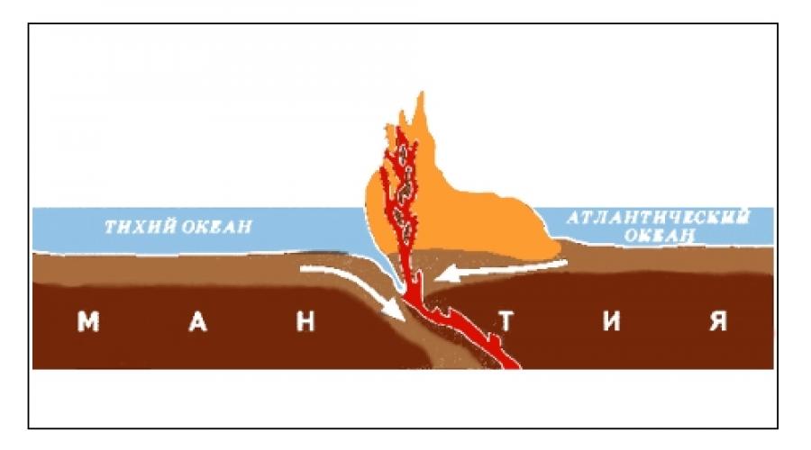
The currents of the mantle continued to cover Laurasia and Gondwana with a network of cracks and break them apart into many fragments that did not remain in a certain place, but gradually diverged in different directions. They were driven by currents within the mantle. Some researchers believe that it was these processes that caused the death of dinosaurs, but this question remains open. Gradually, between the diverging fragments - the continents - the space was filled with mantle matter, which rose from the bowels of the Earth. Cooling down, it formed the bottom of the future oceans. Over time, three oceans appeared here: Atlantic, Pacific, Indian. According to many scientists, the Pacific Ocean is the remnant of the ancient ocean of Panthalassa.
Later, new faults covered Gondwana and Laurasia. At first, the land was isolated from Gondwana, which now constitutes Australia and Antarctica. She began to drift southeast. Then she split into two unequal parts. The smaller one - Australia - rushed to the north, the larger one - Antarctica - to the south and took its place inside the Antarctic Circle. The rest of Gondwana split into several plates, the largest of which are African and South American. These plates are now diverging from each other at a rate of 2 cm per year (see Lithospheric plates).
The faults also covered Laurasia. It split into two plates - North American and Eurasian, which make up most of the continent of Eurasia. The emergence of this continent is the greatest cataclysm in the life of our planet. Unlike all other continents, which are based on one fragment of the ancient continent, Eurasia includes 3 parts: Eurasian (part of Laurasia), Arabian (Gondwana ledge) and Indo-stan (part of Gondwana) lithospheric plates. Approaching each other, they almost destroyed the ancient Tethys Ocean. Africa also participates in the formation of the appearance of Eurasia, the lithospheric plate of which, albeit slowly, is approaching the Eurasian plate. The result of this convergence are the mountains: the Pyrenees, Alps, Carpathians, Sudetes and Ore Mountains (see Lithospheric Plates).
The convergence of the Eurasian and African lithospheric plates is still taking place, this is reminded of the activity of the Vesuvius and Etna volcanoes, disturbing the tranquility of the inhabitants of Europe.
The convergence of the Arabian and Eurasian lithospheric plates led to crushing and crushing into folds of rocks that fell on their way. This was accompanied by violent volcanic eruptions. As a result of the convergence of these lithospheric plates, the Armenian Highlands and the Caucasus arose.
The convergence of the Eurasian and Hindustan lithospheric plates made the entire continent shudder from the Indian Ocean to the Arctic, while Hindustan itself, which initially broke away from Africa, suffered slightly. The result of this rapprochement was the emergence of the highest plateau in the world, Tibet, surrounded by even higher chains of mountains - the Himalayas, Pamir, Karakorum. It is not surprising that it is here, in the place of the strongest compression of the earth's crust of the Eurasian lithospheric plate, that the highest peak of the Earth is located - Everest (Chomolungma), rising to a height of 8848 m.
The "march" of the Hindustan lithospheric plate could lead to a complete split of the Eurasian plate, if there were no parts inside it that could withstand the pressure from the south. Eastern Siberia acted as a worthy "defender", but the lands located to the south of it crumpled into folds, split up and moved.
So, the struggle between continents and oceans has been going on for more than one hundred million years. The main participants in it are continental lithospheric plates. Every mountain ridge, island arc, deepest oceanic depression is the result of this struggle.
2. The structure of continents and oceans
Continents and oceans are the largest elements in the structure of the Earth's crust. When talking about the oceans, one should bear in mind the structure of the crust within the areas occupied by the oceans.
The composition of the earth's crust is continental and oceanic. This, in turn, leaves an imprint on the features of their development and structure.
The boundary between the mainland and the ocean is drawn along the foot of the continental slope. The surface of this foot is an accumulative plain with large hills, which are formed due to underwater landslides and alluvial cones.
In the structure of the oceans, areas are distinguished according to the degree of tectonic mobility, which is expressed in manifestations of seismic activity. On this basis, there are:
Seismically active areas (ocean moving belts),
· Aseismic areas (ocean basins).
The mobile belts in the oceans are represented by mid-ocean ridges. Their length is up to 20,000 km, their width is up to 1000 km, and their height reaches 2-3 km from the bottom of the oceans. In the axial part of such ridges, rift zones are almost continuously traced. They are marked by high heat flux values. Mid-ocean ridges are considered stretching areas of the earth's crust or spreading zones.
The second group of structural elements is ocean basins or thalassocratons. These are flat, slightly hilly areas of the seabed. The thickness of the sedimentary cover here is no more than 1000 m.
Another major element of the structure is the transition zone between the ocean and the mainland (continent); some geologists call it a mobile geosynclinal belt. This is the area of maximum dismemberment of the earth's surface. This includes:
1-island arcs, 2 - deep-water trenches, 3 - deep-water depressions of the marginal seas.
Island arcs are extended (up to 3000 km) mountain structures formed by a chain of volcanic structures with a modern manifestation of basaltic andesite volcanism. An example of island arcs is the Kuril-Kamchatka Ridge, the Aleutian Islands, etc. On the ocean side, island arcs are replaced by deep-water trenches, which are deep-water depressions 1500–4000 km long and 5–10 km deep. The width is 5–20 km. The bottoms of the gutters are covered with sediments, which are brought here by turbid streams. The slopes of the gutters are stepped with different angles of inclination. No precipitation was found on them.
The boundary between the island arc and the slope of the trench represents the zone of concentration of earthquake foci and is called the Wadati-Zavaritsky-Benioff zone.
Considering the features of modern ocean margins, geologists, relying on the principle of actualism, carry out a comparative historical analysis of similar structures that were formed in more ancient periods. These signs include:
Marine type of sediments with a predominance of deep-sea sediments,
Linear form of structures and bodies of sedimentary strata,
A sharp change in the thickness and material composition of sedimentary and volcanic strata in the strike cross of folded structures,
High seismicity,
· A specific set of sedimentary and magmatic formations and the presence of formations - indicators.
Of the listed signs, the latter is one of the leading. Therefore, we will define what a geological formation is. First of all, it is a material category. In the hierarchy of the earth's crust, you know the following sequence:
A geological formation is a more complex stage of development following a rock. It represents regular associations of rocks, connected by the unity of the material composition and structure, which is due to the commonality of their origin or coexistence. Geological formations are distinguished in groups of sedimentary, igneous and metamorphic rocks.
For the formation of stable associations of sedimentary rocks, the main factors are the tectonic setting and climate. We will consider examples of formations and the conditions for their formation when analyzing the development of the structural elements of the continents.
On the continents, two types of regions are distinguished.
Type I coincides with mountainous regions in which sedimentary deposits are crumpled into folds and broken by various faults. Sedimentary strata are broken by igneous rocks and metamorphosed.
Type II coincides with flat areas where deposits are almost horizontal.
The first type is called a folded region or folded belt. The second type is called a platform. These are the main elements of the continents.
Folded regions are formed at the site of geosynclinal belts or geosynclines. A geosyncline is a mobile extended area of deep deflection of the earth's crust. It is characterized by the accumulation of thick sedimentary strata, prolonged volcanism, a sharp change in the direction of tectonic movements with the formation of folded structures.
Geosynclines are subdivided into:
The continental type of the earth's crust is oceanic. Therefore, the ocean floor itself includes the ocean floor depressions located behind the continental slope. These huge depressions differ from the continents not only in the structure of the earth's crust, but also in their tectonic structures. The most extensive areas of the ocean floor are deep-water plains located at depths of 4-6 km and ...
And depressions with abrupt elevation changes measured in hundreds of meters. All these structural features of the axial strip of the median ridges should obviously be understood as a manifestation of intense block tectonics, and the axial depressions are grabens, and on either side of them the median ridge is broken into uplifted and subsided boulders by breaks. The whole set of structural features characterizing ...
The primary basalt layer of the Earth was formed. The Archean was characterized by the formation of primary large reservoirs (seas and oceans), the appearance of the first signs of life in the aquatic environment, the formation of the ancient relief of the Earth, similar to the relief of the Moon. Several folding epochs occurred in the Archean. A shallow ocean has formed with many volcanic islands. An atmosphere containing vapors has formed ...
The water in the South Passat Current is 22 ... 28 ° С, in the East Australian in winter from north to south it varies from 20 to 11 ° С, in summer - from 26 to 15 ° С. The Circumpolar Antarctic Current, or the current of the Western Winds, enters the Pacific Ocean south of Australia and New Zealand and moves in a sublatitudinal direction to the shores of South America, where its main branch deviates to the north and, passing along the coasts ...
Work No. 1, 2016-2017 academic year
The structures of the earth's crust of continents and oceans
The outer shell of the Earth is called crust... The lower boundary of the earth's crust was objectively established using seismographic studies at the beginning of the twentieth century. by the Croatian geophysicist A. Mohorovic on the basis of an abrupt increase at a certain depth of the velocity of the waves. This indicated an increase in the density of rocks and a change in their composition. The boundary is called the surface of Mohorovichich (Moho). Below this boundary, dense ultrabasic rocks of the upper mantle, depleted in silica and enriched in magnesium (peridotites, dunites, etc.), actually occur. The depth of the Moho surface determines the thickness of the earth's crust, which is thicker under the continent than under the oceans.
During the study of the earth's crust, it was also discovered its unequal structure under the continents, including their underwater margins, and oceanic depressions.
Continental (continental) crust consists of a thin discontinuous sedimentary layer; the second granite-metamorphic layer (granites, gneisses, crystalline schists, etc.) and the third, so-called basalt layer, which, most likely, consists of dense metamorphic (granulites, eclogites) and igneous (gabbro) rocks. The maximum thickness of the continental crust is 70-75 km under the high mountains - the Himalayas, Andes, etc.
Oceanic crust thinner, and there is no granite-metamorphic layer in it. A thin layer of unconsolidated sediments lies on top. Below the second, there is a basalt layer, in the upper part of which basalt pillow lavas alternate with thin interlayers of sedimentary rocks, in the lower part there is a complex of parallel basaltic dikes. The third layer consists of igneous crystalline rocks of predominantly basic composition (gabbro, etc.). The thickness of the oceanic crust is 6-10 km.
In the transition zones from the continents to the ocean floor - modern mobile belts - there are transitional subcontinental and suboceanic types of the earth's crust of medium thickness.
The bulk of the earth's crust is composed of igneous and metamorphic rocks, although their outcrops on the day's surface are small. Of the igneous rocks, the most common are intrusive rocks - granites and effusive - basalts, from metamorphic rocks - gneisses, shales, quartzites, etc.
On the surface of the Earth, due to many external factors, various precipitations accumulate, which then over several million years as a result diagenesis(compaction and physical and biochemical changes) are transformed into sedimentary rocks: clayey, detrital, chemical, etc.
Internal relief-forming processes
Mountains, plains and hills differ in height, nature of bedding of rocks, time and method of formation. Both internal and external forces of the Earth participated in their creation. All modern relief-forming factors are divided into two groups: internal ( endogenous) and external ( exogenous).
The energy basis of internal relief-forming processes is the energy coming from the depths of the earth - rotational, radioactive decay and the energy of geochemical accumulators. Rotational energy associated with the release of energy when the Earth's rotation around its axis slows down due to the influence of friction (fractions of seconds per millennium). Energy of geochemical accumulators- this is the energy of the Sun accumulated over many millennia in rocks, which is released when rocks sink into the inner layers.
Exogenous (external forces) are called so because the main source of their energy is outside the Earth - this is energy directly coming from the Sun. For the manifestation of the action of exogenous forces, the unevenness of the earth's surface must be involved, creating a potential difference and the possibility of moving particles under the influence of gravity.
Internal forces tend to create irregularities, and external ones - to align these irregularities.
Internal forces create structure(the basis) of the relief, and external forces act as a sculptor, processing "irregularities created by internal forces. Therefore, endogenous forces are sometimes called primary, and external forces are called secondary. But this does not mean that external forces are weaker than internal ones. For geological history, the results of the manifestation of these forces comparable.
We can observe the processes taking place inside the Earth in tectonic movements, earthquakes and volcanism. The entire set of horizontal and vertical movements of the lithosphere is called tectonic movements. They are accompanied by the appearance of faults and folds in the earth's crust.
For a long time, science was dominated by "platform-geosynclinal" concept the development of the relief of the Earth. Its essence lies in the identification of calm and mobile areas of the earth's crust, platforms and geosynclines. It is assumed that the evolution of the structure of the earth's crust proceeds from geosynclines to platforms. There are two major stages in the development of geosynclines.


The first (main in terms of duration) stage of immersion with a marine regime, the accumulation of a thick (up to 15-20 km) strata of sedimentary and volcanic rocks, the outpouring of lavas, metamorphism, and subsequently with folding. The second stage (shorter in duration) - folding and rupture with a general uplift (mountain building), resulting in the formation of mountains. The mountains are subsequently destroyed by exogenous forces.
In recent decades, most scientists have adhered to a different hypothesis - lithospheric plate hypotheses. Lithospheric plates- These are vast areas of the earth's crust that move along the asthenosphere at a speed of 2-5 cm / year. Distinguish between continental and oceanic plates, when they interact, the thinner edge of the oceanic plate sinks under the edge of the continental plate. As a result, mountains, deep-sea trenches, island arcs are formed (for example, the Kuril Trench and the Kuril Islands, the Atakama Trench and the Andes Mountains). When continental plates collide, mountains are formed (for example, the Himalayas when the Indo-Australian and Eurasian plates collide). Plate movements can be caused by convective movements of the mantle material. In places where this substance rises, faults are formed, and the plates begin to move. The intruding magma along the faults solidifies and builds up the edges of the diverging plates - this is how mid-ocean ridges, stretching along the bottom of all oceans and forming a single system with a length of 60,000 km. Their height reaches 3 km, and their width is the greater, the greater the speed of expansion.
The number of lithospheric plates is not constant - they join and separate into parts during the formation of rifts, large linear tectonic structures, such as deep gorges in the axial part of the mid-oceanic ridges. It is believed that in the Paleozoic, for example, the modern southern continents were one continent - Gondwana, northern - Laurasia, and even earlier there was a single supercontinent - Pangea and one ocean.
Along with slow horizontal movements in the lithosphere, vertical ones also occur. When plates collide or when the load on the surface changes, for example, due to the melting of large ice sheets, an uplift occurs (the Scandinavian Peninsula is still experiencing an uplift). Such vibrations are called glacioisostatic.
Tectonic movements of the earth's crust of the Neogene-Quaternary time are called neotectonic. These movements have manifested and are manifested with different intensities almost everywhere on Earth.
Tectonic movements are accompanied by earthquakes(jerks and rapid vibrations of the earth's surface) and volcanism(the introduction of magma into the earth's crust and its outpouring to the surface).
Earthquakes are characterized by the depth of the source (the place of displacement in the lithosphere, from which seismic waves propagate in all directions) and the strength of the earthquake, assessed by the degree of destruction caused by it in points on the Richter scale (from 1 to 12). The greatest strength of the earthquake reaches directly above the source - at the epicenter. In volcanoes, a magma chamber and a channel or fissures are distinguished along which lava rises.
Most earthquakes and active volcanoes are confined to the outskirts of lithospheric plates - the so-called seismic belts... One of them encircles the Pacific Ocean along the perimeter, the other stretches across Central Asia from the Atlantic Ocean to the Pacific.
External relief-forming processes
Exogenous forces excited by the energy of the sun's rays and gravity, on the one hand, destroy the forms created by endogenous forces, on the other, they create new forms. In this process, there are:
1) destruction of rocks (weathering - it does not create relief forms, but prepares the material);
2) removal of destroyed material, usually downslope drift (denudation); 3) redeposition (accumulation) of the material being removed.
The most important agents in the manifestation of external forces are air and water.
Distinguish physical, chemical and biogenic weathering.
Physical weathering occurs due to unequal expansion and contraction of rock particles with temperature fluctuations. It is especially intense during the transitional seasons and in areas with a continental climate, large daily temperature ranges - on the Sahara highlands or in the Siberian mountains, while whole stone rivers - kurums - are often formed. If water penetrates into cracks in rocks, and then, solidifying and expanding, enlarges these cracks, they speak of frost weathering.
Chemical weathering- This is the destruction of rocks and minerals under the influence of active substances (oxygen, carbon dioxide, salts, acids, alkalis, etc.) contained in the air, water, rocks and soils as a result of chemical reactions. For chemical weathering, on the contrary, humid and warm conditions are favorable, typical of coastal regions, humid tropics and subtropics.
Biogenic weathering is often reduced to chemical and physical effects on rocks of organisms.
Usually, several types of weathering are observed simultaneously, and when they talk about physical or chemical weathering, this does not mean that other forces are not involved in this - just the name is given according to the leading factor.
Water is the "sculptor of the face of the earth" and one of the most powerful agents of relief reconstruction. Flowing water affect the relief, destroying rocks. Temporary and permanent water flows, rivers and streams for millions of years "bite" into the earth's surface, erode it (erosion), move and re-deposit the washed away particles. If it were not for the constant uplift of the earth's crust, only 200 million years would be enough for the water to wash away all areas protruding above the sea and the entire surface of our planet would represent a single boundless ocean. The most common erosional landforms are linear erosion forms: river valleys, ravines and gullies.
To understand the processes of the formation of such forms, it is important to realize that basis of erosion(the place where the water rushes, the level at which the flow loses its energy - for rivers this is the mouth or place of confluence, or a rocky area in the channel) changes its position over time. Usually, it decreases when the river erodes the rocks along which it flows, this happens especially intensively with an increase in the water content of rivers or tectonic fluctuations.
Ravines and gullies are formed by temporary streams that occur after snow melt or heavy rains. They differ among themselves in that the ravines are constantly growing, cutting into loose rocks, narrow steep-sloping ruts, and the gullies, which have a wide bottom and have ceased their development, are occupied by meadows or forests.
Rivers create a wide variety of landforms. In river valleys, the following forms are distinguished: indigenous coast(river sediments do not participate in its structure), understand(part of the valley flooded during floods or floods), terraces(former floodplains that rose above the edge as a result of lowering the base of erosion), old women(sections of the river, separated as a result of meandering from the previous channel).
In addition to natural factors (the presence of surface slopes, easily eroded soils, heavy rainfall, etc.), the formation of erosional forms is promoted by irrational human activity - clear deforestation and plowing of slopes.
Besides water, wind is an important factor in exogenous forces. It usually has less strength than water, but working with loose material can work wonders. The forms created by the wind are called aeolian... They are predominant in dry areas, or where dry conditions were in the past ( relict aeolian forms). it dunes(crescent-shaped sand hills) and dunes(oval hills), chiseled rocks.
Tasks
Exercise 1.
Based on the available information presented in the table, assume in which mountain system the number of altitudinal zones will be the largest. Justify your answer.
Task 2.
The ship is at a point with coordinates 30 S. NS. 70 c. d. crashed, the radio operator transmitted the coordinates of his ship and asked for help. Two ships "Nadezhda" (30 S lat. 110 E) and "Vera" (20 S lat. 50 E) headed for the disaster area. Which ship will come faster to the aid of a dying ship?
Task 3.
Where are: 1) horse latitudes; 2) roaring latitudes; 3) frantic latitudes? What natural phenomena are typical for these places? Explain the origin of their names.
Task 4.
In different countries they are called differently: ushkuiniks, corsairs, filibusters. When was their golden age? Where was the main area of their concentration? In what areas did they hunt in Russia? Why exactly here? Name the most famous person in the world whose name is engraved on maps. Why is this geographic feature interesting?
Task 5.
Before setting off in 1886 on a round-the-world voyage on this corvette, its captain wrote in his diary: “ The commander's job is to name his ship… ”He managed to achieve his goal - oceanographic research, carried out during the expedition that lasted almost three years, made the corvette so famous that later it became a tradition to call scientific research vessels by its name.
What was the name of the corvette? What achievements of science and geographical discoveries became famous for the four ships that at different times bore this proud name? What do you know about the captain, the excerpt from the diary of which is given in the assignment?
Tests
1 ... According to the theory of plate tectonics, the earth's crust and upper mantle are divided into large blocks. Russia is located on the lithospheric plate
1) African 2) Indo-Australian 3) Eurasian 4) Pacific
2. Please indicate wrong statement:
1) The sun at noon in the Northern Hemisphere is in the south;
2) lichens grow thicker on the north side of the trunk;
3) the azimuth is counted from the south direction counterclockwise;
4) a device with which you can navigate is called a compass.
3. Determine the approximate height of the mountain if it is known that at its foot the air temperature was + 16 ° C, and at its top –8 ° C:
1) 1.3 km; 2) 4 km; 3) 24 km; 4) 400 m.
4. Which statement about lithospheric plates is correct?
1) The mid-ocean ridges are confined to the zone of divergence of oceanic lithospheric plates
2) The boundaries of the lithospheric plates exactly coincide with the contours of the continents
3) The structure of continental and oceanic lithospheric plates is the same
4) When lithospheric plates collide, vast plains are formed
5. What is the numerical scale of the plan, at which the distance from the bus stop to the stadium, which is 750 m, is shown as a 3 cm line.
1) 1: 25 2) 1: 250 3) 1: 2500 4) 1: 25 000 5) 1: 250 000
6 ... Which arrow on the fragment of the world map corresponds to the direction to the southeast?

7. The science of place names:
1) geodesy; 2) cartography; 3) toponymy; 4) topography.
8. Name the amazing “architects”, as a result of whose tireless activity various forms of relief dominate on the Earth. __________________________________________________________________
9. Please provide the correct statement.
1) the East European Plain has a flat surface;
2) Altai mountains are located on the Eurasia mainland;
3) Volcano Klyuchevskaya Sopka is located on the Scandinavian Peninsula;
4) Mount Kazbek - the highest peak in the Caucasus.
10. Which of the listed landforms is of glacial origin?
1) moraine ridge 2) dune 3) plateau 4) dune
11. What scientific hypothesis are the lines of Vladimir Vysotsky devoted to?
“At first there was a word of sadness and longing,
The planet was born in the throes of creativity -
Huge pieces were torn from land to nowhere
And they became islands somewhere "
1) the search for Atlantis; 2) the death of Pompeii; 3) continental drift;
4) the formation of the solar system.
12. The lines of the tropics and polar circles are the boundaries ...
1) climatic zones; 2) natural areas; 3) geographical areas;
4) belts of illumination.
13. The absolute height of the Kilimanjaro volcano is 5895 m.Calculate its relative height if it was formed on a plain that rises 500 m above sea level:
1) 5395 m; 2) 5805m; 3) 6395; 4) 11.79 m
14 ... The speed of movement of lithospheric plates relative to each other
is 1-12
1) mm / year 2) cm / month 3) cm / year 4) m / year
15 ... Place objects according to their geographic location from west to east:
1) the Sahara Desert; 2) the Atlantic Ocean; 3) the city of the Andes; 4) about. New Zealand.
1. Deep structure of the Earth
The geographic envelope interacts, on the one hand, with the deep matter of the planet, and on the other, with the upper layers of the atmosphere. The deep structure of the Earth has a significant impact on the formation of the geographic envelope. The term "structure of the Earth" usually denotes its internal, ie, deep structure, starting from the earth's crust and to the center of the planet.
The mass of the Earth is 5.8 x 10 27 g.
The average density of the Earth is 5.517 g / cm 3.
Composition of the Earth. According to modern scientific concepts, the Earth consists of the following chemical elements: iron - 34, 64%, oxygen - 29, 53%, silicon - 15, 20%, magnesium - 12, 70%, nickel - 2, 39%, sulfur - 1 , 93%, chromium - 0, 26%, manganese - 0, 22%, cobalt - 0, 13%, phosphorus - 0, 10%, potassium - 0, 07%, etc.
The most reliable data on the internal structure of the Earth are provided by observations of seismic waves, i.e., oscillatory movements of the earth's matter caused by earthquakes.
A sharp change in the speed of seismic waves (recorded on seismographs) at a depth of 70 km and 2900 km reflects an abrupt increase in the density of matter at these limits. This gives grounds to isolate the following three shells (geospheres) in the inner body of the Earth: to a depth of 70 km - the earth's crust, from 70 km to 2,900 km - the mantle, and from it to the center of the Earth - the core. In the core, the outer core and the inner core are distinguished.
The Earth was formed about 5 billion years ago from some cold gas-dust nebula. After the planet's mass reached its present value (5.98 x 10 27 g), its self-heating began. The main sources of heat were: firstly, gravitational compression, and secondly, radioactive decay. As a result of the development of these processes, the temperature inside the Earth began to rise, which led to the melting of metals. Since in the center of the Earth the matter was strongly compressed, and from the surface it was cooled by radiation, melting took place mainly at shallow depths. Thus, a molten layer was formed, from which silicate materials, as the lightest, rose upward, giving rise to the earth's crust. Metals remained at the melting level. Since their density is higher than that of undifferentiated deep matter, they gradually subsided. This led to the formation of a metal core.
The NUCLEUS is 85-90% iron. At a depth of 2,900 km (the boundary between the mantle and the core), the substance is in a superhard state due to the tremendous pressure (1,370,000 atm.). Scientists speculate that the outer core is melted and the inner core is solid. Differentiation of terrestrial matter and separation of the core is the most powerful process on Earth and the main, first internal driving mechanism for the development of our planet.
The role of the nucleus in the formation of the Earth's magnetosphere. The core has a powerful effect on the formation of the Earth's magnetosphere, which protects life from harmful ultraviolet radiation. In the electrically conductive outer liquid core of a rapidly rotating planet, complex and intense movements of matter occur, leading to the excitation of a magnetic field. The magnetic field extends into near-earth space for several earthly radii. Interacting with the solar wind, the geomagnetic field creates the Earth's magnetosphere. The upper boundary of the magnetosphere is located at an altitude of about 90 thousand km. The formation of the magnetosphere and the isolation of terrestrial nature from the plasma of the solar corona was the first and one of the most important conditions for the origin of life, the development of the biosphere and the formation of the geographic envelope.
The MANTLE is composed primarily of Mg, O, FeO and SiO2, which form magma. Magma contains water, chlorine, fluorine and other volatile substances. In the mantle, the process of differentiation of matter continuously proceeds. Substances facilitated by the removal of metals rise in the direction of the earth's crust, while the heavier ones sink. Such movements of matter in the mantle are termed "convection currents".
The concept of the asthenosphere. The upper part of the mantle (within 100-150 km) is called the asthenosphere. In the asthenosphere, the combination of temperature and pressure is such that the substance is in a molten, mobile state. In the asthenosphere, not only constant convection currents occur, but also horizontal asthenospheric currents.
The speed of horizontal asthenospheric currents reaches only a few tens of centimeters per year. However, over geological time, these currents have led to the splitting of the lithosphere into separate blocks and their horizontal movement, known as continental drift. The asthenosphere contains volcanic foci and earthquake centers. Scientists believe that geosynclines are formed above the descending currents, and the mid-oceanic ridges and rift zones above the ascending ones.
2. The concept of the earth's crust. Hypotheses explaining the origin and development of the earth's crust
The Earth's crust is a complex of surface layers of the Earth's solid body. In the scientific geographical literature, there is no unified understanding of the origin and development of the earth's crust.
There are several hypotheses (theories) explaining the mechanism of formation and development of the earth's crust. The most reasonable hypotheses are as follows:
- 1. The theory of fixism (from Lat. Fixus - motionless, unchanging) asserts that the continents have always remained in the places they currently occupy. This theory denies any movement of continents and large parts of the lithosphere (Charles Darwin, A. Wallace, etc.).
- 2. The theory of mobilism (from the Latin mobilis - mobile) proves that the blocks of the lithosphere are in constant motion. This concept has been especially established in recent years in connection with the receipt of new scientific data in the study of the bottom of the World Ocean.
- 3. The concept of continental growth at the expense of the ocean floor assumes that the original continents were formed in the form of relatively small massifs, which now constitute ancient continental platforms. Subsequently, these massifs grew due to the formation of mountains on the ocean floor, adjacent to the edges of the original land cores. The study of the ocean floor, especially in the zone of the mid-oceanic ridges, gave rise to doubts about the correctness of this concept.
- 4. The theory of geosynclines states that the increase in the size of the land occurs through the formation of mountains in the geosynclines. The geosynclinal process, as one of the main processes in the development of the earth's crust of continents, is the basis of many modern scientific explanations.
- 5. The rotational theory bases its explanation on the proposition that since the figure of the Earth does not coincide with the surface of a mathematical spheroid and is rearranged due to uneven rotation, the zonal stripes and meridional sectors on a rotating planet are inevitably tectonically unequal. They react with varying degrees of activity to tectonic stresses caused by intraterrestrial processes.
Oceanic and continental crust. There are two main types of the earth's crust: oceanic and continental. Its transitional type is also distinguished.
Oceanic crust. The thickness of the oceanic crust in the modern geological epoch ranges from 5 to 10 km. It consists of the following three layers:
- 1) the upper thin layer of marine sediments (thickness no more than 1 km);
- 2) middle basalt layer (thickness from 1.0 to 2.5 km);
- 3) the lower layer of gabbro (about 5 km thick).
Continental (continental) crust. The continental crust has a more complex structure and greater thickness than the oceanic one. Its capacity is on average 35-45 km, and in mountainous countries it increases to 70 km. It consists of the following three layers:
- 1) the lower layer (basalt), composed of basalts (thickness about 20 km);
- 2) middle layer (granite), formed mainly by granites and gneisses; forms the main thickness of the continental crust, does not extend under the oceans;
- 3) the upper layer (sedimentary) about 3 km thick.
In some areas, the thickness of precipitation reaches 10 km: for example, in the Caspian lowland. In some areas of the Earth, the sedimentary layer is absent altogether and a layer of granite comes out on the surface. Such areas are called shields (for example, Ukrainian Shield, Baltic Shield).
On the continents, as a result of the weathering of rocks, a geological formation is formed, which is called the weathering crust.
The granite layer is separated from the basalt layer by the Konrad surface. At this boundary, the speed of seismic waves increases from 6.4 to 7.6 km / sec.
The boundary between the earth's crust and the mantle (both on the continents and on the oceans) runs along the surface of Mohorovichich (the Moho line). The speed of seismic waves on it abruptly increases to 8 km / h.
In addition to the two main types of the earth's crust (oceanic and continental), there are also areas of a mixed (transitional) type.
On continental shoals or shelves, the crust has a thickness of about 25 km and is generally similar to the continental crust. However, a layer of basalt can fall out in it. In East Asia, in the area of island arcs (Kuril Islands, Aleutian Islands, Japanese Islands, etc.), the earth's crust is of a transitional type. Finally, the crust of the mid-oceanic ridges is very complex and little studied so far. There is no Moho boundary here, and the mantle material rises along faults into the crust and even to its surface.
The concept of "earth's crust" should be distinguished from the concept of "lithosphere". The concept of "lithosphere" is broader than the "crust". In the lithosphere, modern science includes not only the earth's crust, but also the uppermost mantle up to the asthenosphere, that is, to a depth of about 100 km.
The concept of isostasy. The study of the distribution of gravity showed that all parts of the earth's crust - continents, mountainous countries, plains - are balanced on the upper mantle. This balanced position of them is called isostasy (from Latin isoc - even, stasis - position). Isostatic equilibrium is achieved due to the fact that the thickness of the earth's crust is inversely proportional to its density. The heavy oceanic crust is thinner than the lighter continental crust.
Isostasy is not even equilibrium, but a striving for equilibrium, continuously disturbed and restored again. For example, after the melting of continental ice of the Pleistocene glaciation, the Baltic Shield rises by about 1 cm per year. The area of Finland is constantly increasing due to the seabed. The territory of the Netherlands, on the contrary, is decreasing. The zero line of equilibrium is currently located somewhat south of 600 N. Modern St. Petersburg is about 1.5 m higher than St. Petersburg during the time of Peter the Great. As the data of modern scientific research show, even the severity of large cities is sufficient for the isostatic fluctuation of the territory below them. Therefore, the earth's crust in the zones of large cities is very mobile. In general, the relief of the earth's crust is a mirror image of the Moho surface (the bottom of the earth's crust): elevated areas correspond to depressions in the mantle, and lower areas correspond to a higher level of its upper boundary. So, under the Pamir, the depth of the Moho surface is 65 km, and in the Caspian lowland - about 30 km.
Thermal properties of the earth's crust. Daily fluctuations in soil temperature extend to a depth of 1.0-1.5 m, and annual fluctuations in temperate latitudes in countries with a continental climate - to a depth of 20-30 m.At the depth where the influence of annual temperature fluctuations ceases due to heating of the earth's surface by the Sun , there is a layer of constant soil temperature. It is called an isothermal layer. Below the isothermal layer deep into the Earth, the temperature rises. But this rise in temperature is already caused by the internal warmth of the earth's interior. Internal heat is practically not involved in the formation of climates. However, it serves as the only energy basis for all tectonic processes.
The number of degrees by which the temperature increases for every 100 m depth is called the geothermal gradient.
The distance in meters, when descending to which the temperature rises by 10C, is called a geothermal step. The magnitude of the geothermal step depends on the relief, thermal conductivity of rocks, the proximity of volcanic foci, groundwater circulation, etc. On average, the geothermal step is 33 m.In volcanic areas, the geothermal step can be only 5 m, and in geologically quiet areas (on platforms) it can reach 100 m.
3. Structural-tectonic principle of separation of continents. The concept of continents and parts of the world
Two qualitatively different types of the earth's crust - continental and oceanic - correspond to two main levels of planetary relief - the surface of the continents and the ocean floor. The selection of continents in modern geography is carried out on the basis of the structural-tectonic principle.
Structural-tectonic principle of separation of continents.
The fundamentally qualitative difference between the continental and oceanic crust, as well as some significant differences in the structure of the upper mantle under the continents and oceans, oblige to distinguish continents not by their apparent surroundings by oceans, but by the structural-tectonic principle.
The structural-tectonic principle states that, firstly, the continent includes a continental shelf (shelf) and a continental slope; secondly, at the base of each continent there is a core or an ancient platform; third, each continental lump is isostatically balanced in the upper mantle.
From the point of view of the structural-tectonic principle, a continent is called an isostatically balanced mass of the continental crust, which has a structural core in the form of an ancient platform, to which younger folded structures adjoin.
There are six continents on Earth: Eurasia, Africa, North America, South America, Antarctica and Australia. Each continent has one platform, and only at the basis of Eurasia there are six of them: Eastern European, Siberian, Chinese, Tarim (Western China, Taklamakan desert), Arabian and Hindustan. The Arabian and Hindustan platforms are parts of ancient Gondwana that joined Eurasia. Thus, Eurasia is a heterogeneous anomalous continent.
The boundaries between the continents are quite obvious. The border between North America and South America runs along the Panama Canal. The border between Eurasia and Africa is drawn along the Suez Canal. The Bering Strait separates Eurasia from North America.
Two rows of continents. In modern geography, the following two series of continents stand out:
- 1. Equatorial continents (Africa, Australia and South America).
- 2. Northern row of continents (Eurasia and North America).
Outside of these ranks is Antarctica - the southernmost and coldest continent.
The modern arrangement of the continents reflects the long history of the development of the continental lithosphere.
The southern continents (Africa, South America, Australia and Antarctica) are parts ("fragments") of the single Paleozoic mega-continent of Gondwana. The northern continents at that time were united into another mega-continent - Laurasia. Between Laurasia and Gondwana in the Paleozoic and Mesozoic, there was a system of vast sea basins, called the Tethys Ocean. This ocean stretched from North Africa (through southern Europe, the Caucasus, Western Asia, the Himalayas to Indochina) to modern Indonesia. In the Neogene (about 20 million years ago), an alpine fold belt arose on the site of this geosyncline.
Corresponding to its large size, the supercontinent Gondwana, according to the law of isostasy, had a powerful (up to 50 km) crust, which was deeply immersed in the mantle. Convection currents were especially intense in the asthenosphere under this supercontinent; the softened material of the mantle moved very actively. This led first to the formation of a bulge in the middle of the continent, and then to its splitting into separate blocks, which, under the action of the same convection currents, began to move horizontally. It is known that the movement of a contour on the surface of a sphere is always accompanied by its rotation (Euler et al.). Therefore, parts of Gondwana not only moved, but also deployed in geographic space.
The first split of Gondwana occurred on the border of the Triassic and Jurassic (about 190-195 million years ago); split off Afro-America. Then, on the Jurassic-Cretaceous border (about 135-140 million years ago), South America separated from Africa. At the border of the Mesozoic and Cenozoic (about 65-70 million years ago), the Hindustan block collided with Asia, and Antarctica moved away from Australia. In the present geological era, the lithosphere, according to scientists, is divided into six plate-blocks that continue to move.
The collapse of Gondwana aptly explains the shape, geological similarity, and the history of the vegetation and fauna of the southern continents. The history of the split in Laurasia has not been studied as thoroughly as in Gondwana.
Regularities of the location of the continents. The modern arrangement of the continents is characterized by the following patterns:
- 1. Most of the land is located in the Northern Hemisphere. The Northern Hemisphere is continental, although here, too, land accounts for only 39%, and about 61% of the ocean.
- 2. Northern continents are located rather compactly. The southern continents are located very scattered and fragmented.
- 3. The relief of the planet is anti-Semitic. The continents are located so that each of them on the opposite side of the Earth certainly corresponds to the ocean. This can be best seen in the comparison of the Arctic Ocean and the Antarctic land. If the globe is set so that any of the continents is at one of the poles, then there will be an ocean at the other pole. There is only one minor exception: the ending of South America is antipodal to Southeast Asia. Antipodality, since it has almost no exceptions, cannot be an accidental phenomenon. This phenomenon is based on the balance of all parts of the surface of the rotating Earth.
The concept of parts of the world. In addition to the geologically determined division of land into continents, there is also the division of the earth's surface into separate parts of the world that has developed in the process of cultural and historical development of mankind. There are six parts of the world in total: Europe, Asia, Africa, America, Australia with Oceania, Antarctica. On one continent of Eurasia there are two parts of the world (Europe and Asia), and two continents of the western hemisphere (North America and South America) form one part of the world - America.
The border between Europe and Asia is very conditional and is drawn along the watershed line of the Ural ridge, the Ural River, the northern part of the Caspian Sea and the Kuma-Manych depression. In the Urals and the Caucasus, there are deep fault lines separating Europe from Asia.
Area of continents and oceans. Land area is calculated within the current coastline. The surface area of the globe is approximately 510, 2 million km2. About 361, 06 million km2 is occupied by the World Ocean, which is approximately 70.8% of the total surface of the Earth. The land area accounts for approximately 149.02 million km 2, i.e. about 29, 2% of the surface of our planet.
The area of modern continents is characterized by the following values:
Eurasia - 53.45 km2, including Asia - 43.45 million km2, Europe - 10.0 million km2;
Africa - 30, 30 million km2;
North America - 24, 25 million km2;
South America - 18, 28 million km2;
Antarctica - 13, 97 million km2;
Australia - 7, 70 million km2;
Australia with Oceania - 8, 89 km2.
Modern oceans have an area:
Pacific Ocean - 179, 68 million km2;
Atlantic Ocean - 93, 36 million km2;
Indian Ocean - 74, 92 million km2;
Arctic Ocean - 13, 10 million km2.
Between the northern and southern continents (in accordance with their different origins and development), there is a significant difference in the area and nature of the surface. The main geographical differences between the northern and southern continents boil down to the following:
- 1. Incomparable in size with other continents Eurasia, which concentrates more than 30% of the land area of our planet.
- 2. The northern continents have a significant shelf area. The shelf is especially significant in the Arctic Ocean and the Atlantic Oceans, as well as in the Yellow, Chinese and Bering Seas of the Pacific Ocean. The southern continents, with the exception of the underwater continuation of Australia in the Arafura Sea, are almost devoid of a shelf.
- 3. Most of the southern continents fall on ancient platforms. In North America and Eurasia, ancient platforms occupy a smaller part of the total area, and most of them are in the territories formed by Paleozoic and Mesozoic mountain building. In Africa, about 96% of its territory falls on platform areas and only 4% - on mountains of Paleozoic and Mesozoic age. In Asia, only 27% of the territory is occupied by ancient platforms and 77% by mountains of various ages.
- 4. The coastline of the southern continents, formed mostly by tectonic faults, is relatively straight; there are few peninsulas and mainland islands. The northern continents are characterized by an exceptionally winding coastline, an abundance of islands, peninsulas, often far reaching the ocean. Of the total area, islands and peninsulas account for about 39% in Europe, North America - 25%, Asia - 24%, Africa - 2.1%, South America - 1.1% and Australia (excluding Oceania) - 1.1% ...
- 4. Vertical dismemberment of the land
Each of the major planetary levels - the surface of the continents and the ocean floor - splits into a number of minor levels. The formation of both main and secondary levels took place in the process of long-term development of the earth's crust and continues in the present geological time. Let us dwell on the modern division of the continental crust into high-altitude steps. The steps are counted from sea level.
- 1. Depression - land areas below sea level. The largest depression on Earth is the southern part of the Caspian Lowland with a minimum elevation of -28 m. Inside Central Asia, there is an extremely dry Turfan depression with a depth of about -154 m. The deepest depression on Earth is the Dead Sea Basin; the shores of the Dead Sea lie 392 m below sea level. Depressions occupied by water, the levels of which lie above the sea level, are called cryptodepressions. Typical examples of cryptodepressions are Lake Baikal and Lake Ladoga. The Caspian Sea and the Dead Sea are not cryptodepressions, because the water level in them does not reach the level of the ocean. The area occupied by depressions (without cryptodepressions) is relatively small and amounts to about 800 thousand km2.
- 2. Lowlands (low-lying plains) - land areas lying at an altitude of 0 to 200 m above sea level. Lowlands are plentiful on every continent (with the exception of Africa) and cover a larger area than any other level of land. The total area of all low-lying plains of the globe is about 48.2 million km2.
- 3. Uplands and plateaus lie at an altitude of 200 to 500 m and differ in the prevailing relief forms: on the uplands the relief is rugged, on the plateau it is comparatively flat. The hills above the lowlands rise gradually, and the plateau - a noticeable ledge. Uplands and plateaus differ from each other and the geological structure. The area occupied by uplands and plateaus is about 33 million km2.
Mountains are located above 500 m. They can be of different origins and ages. In terms of height, the mountains are subdivided into low, medium and high.
- 4. Low mountains rise no higher than 1,000 m. Usually low mountains are either ancient destroyed mountains or foothills of modern mountain systems. Low mountains occupy about 27 million km 2.
- 5. Medium mountains have a height of 1,000 to 2,000 m. Examples of medium-altitude mountains are: Ural, Carpathians, Transbaikalia, some ranges of Eastern Siberia and many other mountainous countries. The area occupied by the middle mountains is about 24 million km 2.
- 6. High (alpine) mountains rise above 2,000 m. The term “alpine mountains” is often applied only to the mountains of the Cenozoic age, lying at an altitude of more than 3,000 m. High mountains account for about 16 million km2.
Below ocean level, the continental lowland, flooded with water, continues - the shelf, or continental shelf. Until recently, according to the same conventional count as the steps of the land, the shelf was called underwater plains with depths of up to 200 m.Now, the shelf boundary is drawn not along the formally chosen isobath, but along the line of the actual, geologically determined end of the continental surface and its transition to the continental slope ... Therefore, the shelf continues in the ocean to different depths in each sea, often exceeding 200 m and reaching 700 and even 1,500 m.
At the outer edge of the relatively flat shelf, there is a sharp break in the surface towards the continental slope and the continental foot. The shelf, slope and foot together form the underwater edge of the continents. It continues on average to a depth of 2,450 m.
The continents, including their underwater margins, occupy about 40% of the Earth's surface, while the land area is about 29.2% of the total terrestrial.
Each continent is isostatically balanced in the asthenosphere. There is a direct relationship between the area of the continents, the height of their relief and the depth of immersion in the mantle. The larger the continent's area, the greater its average height and thickness of the lithosphere. The average height of the land is 870 m.The average height of Asia is 950 m, Europe is 300 m, and Australia is 350 m.
The concept of a hypsometric (bathygraphic) curve. The generalized profile of the earth's surface is represented by a hypsometric curve. The part of it related to the ocean is called the bathygraphic curve. The curve is constructed as follows. The dimensions of the areas lying at different heights and depths are taken from hypsometric and bathygraphic maps and plotted in the coordinate axes: along the ordinate, heights are plotted from 0 upwards, and downwards - depths; along the abscissa - areas in millions of square kilometers.
5. The relief and structure of the ocean floor. Islands
The average depth of the World Ocean is 3,794 m.
The World Ocean floor consists of the following four planetary morphosculptural forms:
- 1) the underwater outskirts of the continents,
- 2) transition zones,
- 3) the ocean bed,
- 4) mid-ocean ridges.
The underwater edge of the continents consists of a shelf, a continental slope, and a continental foot. It sinks to a depth of 2,450 m. The earth's crust here is of a continental type. The total area of the underwater continental margin is about 81.5 million km2.
The continental slope plunges into the ocean relatively steeply, with an average of about 40 inclines, but sometimes they reach 400.
The continental foot is a trough at the border of the continental and oceanic crust. Morphologically, it is an accumulative plain formed by sediments carried from the continental slope.
The mid-ocean ridges are a single and continuous system that encompasses all oceans. They are huge mountain structures, reaching a width of 1-2 thousand km and rising above the ocean bed by 3-4 thousand km. Sometimes mid-ocean ridges rise above ocean level and form numerous islands (Iceland, the Azores, Seychelles, etc.). In grandeur, they significantly surpass the mountainous countries of the continents and are commensurate with the continents. For example, the Mid-Atlantic Ridge is several times larger than the largest terrestrial mountain system of the Cordilleras and the Andes. All mid-ocean ridges are characterized by increased tectonic activity.
The mid-ocean ridge system includes the following structures:
- - Mid-Atlantic Ridge (stretches from Iceland along the entire Atlantic Ocean to the island of Tristan da Cunha);
- - Mid-Indian ridge (its peaks are expressed by the Seychelles);
- - East Pacific Rise (extends south of the California Peninsula).
In terms of relief and features of tectonic activity, mid-oceanic ridges are: 1) rift and 2) non-rift.
Rift ridges (for example, the Mid-Atlantic) are characterized by the presence of a “rift” valley - a deep and narrow gorge with steep slopes (the gorge follows the ridge along its axis). The rift valley is 20-30 km wide, and the depth of the fault can be located below the ocean floor up to 7,400 m (Romanche depression). The relief of the rift ridges is complex and rugged. All ridges of this type are characterized by rift valleys, narrow mountain ranges, giant transverse faults, intermontane depressions, volcanic cones, underwater volcanoes, islands. All rift ridges are characterized by high seismic activity.
Non-rift ridges (for example, the East Pacific Rise) are characterized by the absence of a “rift” valley and have a less complex relief. Seismic activity is not typical for non-rift ridges. However, they have a common feature of all mid-ocean ridges - the presence of grandiose transverse faults.
The most important geophysical features of mid-ocean ridges are as follows:
- -increased value of the heat flux from the bowels of the Earth;
- -specific structure of the earth's crust;
- - magnetic field anomalies;
- -volcanism;
- -seismic activity.
The distribution of sediments that make up the upper layer of the earth's crust in the mid-oceanic ridges obeys the following pattern: on the ridge itself, sediments are thin or absent altogether; with distance from the ridge, the thickness of the sediments (up to several kilometers) and their age increase. If in the cleft itself the age of the lavas is about 13 thousand years, then in 60 km - already 8 million years. Rocks more than 160 million years old have not been found at the bottom of the World Ocean. These facts testify to the constant renewal of the mid-oceanic ridges.
Mechanisms of the formation of mid-oceanic ridges. The formation of mid-oceanic ridges is associated with the upper magma. The upper magma is a huge convection system. According to scientists, the formation of mid-ocean ridges causes the rise of the Earth's internal matter. Along the rift valleys, lava flows out and forms a basalt layer. Joining the old crust, new portions of lava cause horizontal displacement of lithosphere blocks and expansion of the ocean floor. The speed of horizontal movements in different parts of the Earth ranges from 1 to 12 cm per year: in the Atlantic Ocean - about 4 cm / year; in the Indian Ocean - about 6 cm / year, in the Pacific Ocean - up to 12 cm / year. These negligible values, multiplied by millions of years, give enormous distances: in the 150 million years that have passed since the split of South America and Africa, these continents have diverged by 5 thousand km. North America split from Europe 80 million years ago. And 40 million years ago, Hindustan collided with Asia and the formation of the Himalayas began.
As a result of the growth of the ocean floor in the zone of mid-oceanic ridges, there is not an increment of terrestrial matter at all, but only its overflow and transformation. The basalt crust, which grows along the mid-oceanic ridges and spreads horizontally from them, travels thousands of kilometers over millions of years, and at some continental edges sinks back into the bowels of the Earth, taking with it oceanic sediments. This process explains the different ages of rocks on the crest of ridges and in other parts of the oceans. This process also causes continental drift.
Transitional zones include deep-sea trenches, island arcs and basins of the marginal seas. In the transitional zones, areas of the continental and oceanic crust are difficult to combine.
Deep sea trenches are found in the following four regions of the Earth:
- - in the Pacific Ocean along the coasts of East Asia and Oceania: Aleutian Trench, Kuril-Kamchatka Trench, Japanese Trench, Philippine Trench, Mariana Trench (with a maximum depth of 11,022 m for the Earth), West Melanesian Trench, Tonga;
- - in the Indian Ocean - the Javan Trench;
- - in the Atlantic Ocean - the Puerto Rican Trench;
- - in the Southern Ocean - South Sandwich.
The ocean floor, which accounts for about 73% of the total area of the World Ocean, is occupied by deep-water (from 2,450 to 6,000 m) plains. In general, these deep-sea plains correspond to oceanic platforms. Between the plains there are mid-ocean ridges, as well as hills and uplifts of another genesis. These uplifts divide the ocean floor into separate basins. For example, from the North Atlantic Ridge to the west is the North American Basin, and to the east is the West European and Canary Basins. There are numerous volcanic cones on the ocean floor.
Islands. In the process of the development of the earth's crust and its interaction with the World Ocean, large and small islands were formed. The total number of islands is constantly changing. Some islands appear, others disappear. For example, delta islands are formed and eroded, ice masses that were previously taken as islands ("lands") are melting. Spits acquire an insular character and, conversely, islands join the land and turn into peninsulas. Therefore, the area of the islands is calculated only approximately. It is about 9.9 million km2. About 79% of the total island land area falls on 28 large islands. The largest island is Greenland (2.2 million km2).
V The 28 largest islands in the world include the following:
- 1. Greenland;
- 2. New Guinea;
- 3. Kalimantan (Borneo);
- 4. Madagascar;
- 5. Baffin's Land;
- 6. Sumatra;
- 7. Great Britain;
- 8. Honshu;
- 9. Victoria (Canadian Arctic Archipelago);
- 10. Ellesmere Land (Canadian Arctic Archipelago);
- 11. Sulawesi (Celebes);
- 12. South Island of New Zealand;
- 13. Java;
- 14. North Island of New Zealand;
- 15. Newfoundland;
- 16. Cuba;
- 17. Luison;
- 18. Iceland;
- 19. Mindanao;
- 20. New Earth;
- 21. Haiti;
- 22. Sakhalin;
- 23. Ireland;
- 24. Tasmania;
- 25. Banks (Canadian Arctic Archipelago);
- 26. Sri Lanka;
- 27. Hokkaido;
- 28. Devon.
Both large and small islands are located either singly or in groups. Groups of islands are called archipelagos. Archipelagos can be compact (eg Franz Josef Land, Svalbard, Greater Sunda Islands) or elongated (eg Japanese, Philippine, Greater and Lesser Antilles). Elongated archipelagos are sometimes called ridges (for example, the Kuril ridge, the Aleutian ridge). The archipelagos of small islands scattered across the Pacific Ocean are combined into the following three large groups: Melanesia, Micronesia (Caroline Islands, Mariana Islands, Marshall Islands), Polynesia.
By origin, all islands can be grouped as follows:
I. Mainland Islands:
- 1) platform islands,
- 2) islands of the continental slope,
- 3) orogenic islands,
- 4) island arcs,
- 5) coastal islands: a) skerries, b) Dalmatian, c) fjord, d) spits and arrows, e) delta.
II. Independent Islands:
- 1) volcanic islands, including a) fissure outpouring of lava, b) central outpouring of lava - shield and conical;
- 2) coral islands: a) coastal reefs, b) barrier reefs, c) atolls.
The mainland islands are genetically related to the continents, but these connections are of a different nature, which affects the nature and age of the islands, their flora and fauna.
The platform islands lie on the continental shelf and are geologically an extension of the continent. The platform islands are separated from the main land mass by shallow straits. Examples of platform islands are: British Isles, Spitsbergen, Franz Josef Land, Severnaya Zemlya, New Siberian Islands, Canadian Arctic Archipelago.
The formation of straits and the transformation of part of the continents into islands dates back to recent geological times; therefore, the nature of the island land differs little from the mainland.
The islands of the continental slope are also part of the continents, but their separation occurred earlier. These islands are separated from the adjacent continents not by a gentle trough, but by a deep tectonic fault. Moreover, the straits have an oceanic character. The flora and fauna of the islands on the continental slope is very different from the mainland and is generally insular in nature. Examples of islands on the mainland slope are: Madagascar, Greenland, etc.
Orogenic islands are an extension of the mountain folds of the continents. So, for example, Sakhalin is one of the folds of the Far Eastern mountainous country, New Zealand is a continuation of the Urals, Tasmania is the Australian Alps, the islands of the Mediterranean Sea are branches of the Alpine folds. The New Zealand archipelago is also of orogenic origin.
Island arcs line East Asia, America and Antarctica with garlands. The largest region of island arcs is located off the coast of East Asia: Aleutian ridge, Kuril ridge, Japanese ridge, Ryukyu ridge, Philippine ridge, etc. The second region of island arcs is located off the coast of America: Greater Antilles, Lesser Antilles. The third region is an island arc located between South America and Antarctica: the Tierra del Fuego archipelago, the Falkland Islands, etc. Tectonically, all island arcs are confined to modern geosynclines.
The mainland coastal islands have different origins and represent different types of coastline.
Independent islands have never been part of the continents and in most cases were formed independently of them. The largest group of independent islands is volcanic.
There are volcanic islands in all oceans. However, there are especially many of them in the zones of mid-oceanic ridges. The size and characteristics of the volcanic islands are determined by the nature of the eruption. Fissured outpourings of lava create large islands that are not inferior in size to platform ones. The largest island of volcanic origin on Earth is Iceland (103 thousand km2).
The bulk of the volcanic islands is formed by eruptions of the central type. Naturally, these islands cannot be very large. Their area depends on the nature of the lava. The main lava spreads over long distances and forms shield volcanoes (for example, the Hawaiian Islands). The eruption of acidic lava forms a sharp cone of a small area.
Coral islands are the waste products of coral polyps, diatoms, foraminifera and other marine organisms. Coral polyps are quite demanding in terms of living conditions. They can live only in warm waters with a temperature of at least 200C. Therefore, coral structures are common only in tropical latitudes and go beyond them only in one place - in the region of Bermuda, washed by the Gulf Stream.
Depending on their location in relation to modern land, coral islands are divided into the following three groups:
- 1) coastal reefs,
- 2) barrier reefs,
- 3) atolls.
Coastal reefs begin directly off the coast of the mainland or island in the low tide and border it in the form of a wide terrace. Near river mouths and near mangroves, they are interrupted due to the reduced salinity of the water.
Barrier reefs are located at some distance from the land, separated from it by a strip of water - a lagoon. The largest reef at present is the Great Barrier Reef. Its length is about 2,000 km; the width of the lagoon ranges from 35 to 150 km with a depth of 30-70 m. Coastal and barrier reefs border almost all the islands of the equatorial and tropical waters of the Pacific Ocean.
Atolls are located among the oceans. These are low islands in the form of an open ring. The diameter of the atoll ranges from 200 m to 60 km. Inside the atoll there is a lagoon up to 100 m deep. The same is the depth of the strait between the lagoon and the ocean. The outer slope of the atoll is always steep (from 9 to 450). The slopes facing the lagoon are gentle; a variety of organisms inhabit them.
The genetic relationship between the three types of coral structures is a still unsolved scientific problem. According to Charles Darwin's theory, barrier reefs and atolls are formed from coastal reefs as the islands gradually sink. In doing so, the growth of corals compensates for the sinking of its base. A lagoon appears at the top of the island, and the coastal reef turns into a ring atoll.
Types of bark. In different regions, the ratio between different rocks in the earth's crust is different, and the dependence of the composition of the crust on the nature of the relief and the internal structure of the territory is revealed. The results of geophysical studies and deep drilling made it possible to identify two main and two transitional types of the earth's crust. The main types mark such global structural elements of the crust as continents and oceans. These structures are perfectly expressed in the relief of the Earth, and they are characterized by continental and oceanic types of crust.
1 - water, 2 - sedimentary layer, 3 - interbedded sedimentary rocks and basalts, 4 - basalts and crystalline ultrabasic rocks, 5 - granite-metamorphic layer, 6 - granulite-basic layer, 7 - normal mantle, 8 - decompressed mantle.
Continental crust developed under the continents and, as already mentioned, has a different power. Within the platform areas corresponding to the continental plains, it is 35-40 km, in young mountain structures - 55-70 km. The maximum thickness of the earth's crust - 70-75 km - is established under the Himalayas and Andes. In the continental crust, two strata are distinguished: the upper, sedimentary, and lower, consolidated crust. In the consolidated crust, there are two layers of different velocities: the upper granite-metamorphic (according to the obsolete concept, this is a granite layer), composed of granites and gneisses, and the lower granulite-basic (according to outdated concepts, this is a basalt layer), composed of highly metamorphosed basic rocks of the gabbro or ultrabasic type. igneous rocks. The granite-metamorphic layer was studied from the cores of superdeep wells; granulite-basic - according to geophysical data and dredging results, which still makes its existence hypothetical.
In the lower part of the upper layer, a zone of weakened rocks is found, which is not much different from it in composition and seismic characteristics. The reason for its occurrence is the metamorphism of rocks and their decompaction due to the loss of constitutional water. It is likely that the rocks of the granulite-basic layer are all the same rocks, but even more highly metamorphosed.
Ocean crust characteristic of the World Ocean. It differs from the continental in power and composition. Its thickness ranges from 5 to 12 km, averaging 6-7 km. From top to bottom, three layers are distinguished in the oceanic crust: the upper layer of loose marine sedimentary rocks up to 1 km thick; medium, represented by interlayering of basalts, carbonate and siliceous rocks, 1-3 km thick; lower, composed of basic rocks of the gabbro type, often altered by metamorphism to amphibolites, and ultrabasic amphibolites, 3.5-5 km thick. The first two layers are drilled, the third is characterized by dredging material.
Suboceanic crust developed under the deep-sea basins of the marginal and inland seas (Black, Mediterranean, Okhotsk, etc.), and also found in some deep depressions on land (central part of the Caspian basin). The thickness of the suboceanic crust is 10-25 km, and it is increased mainly due to the sedimentary layer lying directly on the lower layer of the oceanic crust.
Subcontinental crust typical for island arcs (Aleutian, Kuril, South Antilles, etc.) and the outskirts of the continents. In structure, it is close to the continental crust, but has a lower thickness - 20-30 km. A feature of the subcontinental crust is the indistinct boundary between the layers of consolidated rocks.
Thus, different types of the earth's crust distinctly divide the Earth into oceanic and continental blocks. The high position of the continents is explained by a more powerful and less dense crust, and the submerged position of the ocean floor is explained by a thinner, but denser and heavier crust. The shelf area is underlain by the continental crust and is the submarine termination of the continents.
Structural elements of the bark
In addition to being divided into such planetary structural elements as oceans and continents, the earth's crust (and lithosphere) reveals regions that are seismic (tectonically active) and aseismic (calm). The inner regions of the continents and the ocean floor - continental and oceanic platforms - are calm. Narrow seismic zones are located between the platforms, which are marked by volcanism, earthquakes, tectonic movements - site. These zones correspond to mid-ocean ridges and junctions of island arcs or marginal mountain ranges and deep-sea trenches at the periphery of the ocean.
The following structural elements are distinguished in the oceans:
- mid-ocean ridges - mobile belts with axial rifts of the graben type;
- oceanic platforms - calm areas of abyssal basins with complicating uplifts.
On the continents, the main building blocks are:
Mountain structures (orogens: from the Greek “oros” - mountain.), Which, like mid-oceanic ridges, can show tectonic activity;
- platforms - generally tectonically calm vast territories with a thick cover of sedimentary rocks.
Mountain structures have a complex internal structure and a history of geological development. Among them, there are orogens composed of young pre-Paleogene marine sediments (Carpathians, Caucasus, Pamir), and older ones, formed from Early Mesozoic, Paleozoic and Precambrian rocks that experienced folding movements. These ancient ridges were denuded, often to the bottom, and in recent times have experienced a secondary uplift. These are the revived mountains (Tien Shan, Altai, Sayan mountains, the Baikal and Transbaikal ranges).
Mountain structures are separated and bordered by low areas - intermontane troughs and depressions, which are filled with products of the destruction of ridges. For example, the Greater Caucasus is bordered by the West Kuban, East Kuban and Tersko-Caspian foredeeps, and from the Lesser Caucasus it is separated by the Rion and Kura intermontane depressions.
But not all ancient mountain structures were involved in re-mountain building. Most of them, after leveling, slowly subsided, were flooded with the sea, and a layer of marine sediments was layered on the relics of the mountain ranges. This is how platforms were formed. The geological structure of the platforms always contains two structural-tectonic levels: the lower one, composed of metamorphosed remnants of the former mountains, which is the foundation, and the upper one, represented by sedimentary rocks.

Platforms with a Precambrian basement are considered ancient, and those with a Paleozoic and early Mesozoic basement are considered young. Young platforms are located between the ancients or border them. For example, a young West Siberian platform is located between the ancient East European and Siberian platforms, and the young Scythian and Turanian platforms begin on the southern and southeastern margins of the East European platform. Within the platforms, large structures of anticlinal and synclinal profiles are distinguished, called anteclises and syneclises.
So, the platforms are ancient denuded orogens, not affected by later (young) mountain building movements.
In contrast to the calm platform regions, there are tectonically active geosynclinal regions on Earth. The geosynclinal process can be compared to the work of a huge deep cauldron, where a new light continental crust is “cooked” from ultrabasic and basic magma and lithosphere material, which, as it emerges, builds up continents in the marginal (Pacific) and solders them in intercontinental (Mediterranean) geosynclines. This process ends with the formation of folded mountain structures, in the vaulted part of which volcanoes can still work for a long time - the site. Over time, the growth of mountains stops, volcanism dies out, the earth's crust enters a new cycle of its development: the alignment of the mountain structure begins.
Thus, where the mountain ranges are now located, there used to be geosynclines. Large structures of anticlinal and synclinal profile in geosynclinal regions are called anticlinoria and synclinoria.
The earth's crust, which has an average thickness of about 40 km and is only 1/160 of the Earth's radius. The earth's crust, together with part of the upper mantle up to the asthenospheric layer, is called the lithosphere, and the lithosphere, together with the asthenosphere, forms the tectonosphere, the upper shell of the earth is largely responsible for the processes occurring in the earth's crust. The structure of the earth's crust, the thickness of which varies practically from 0 to 70-75 km and everywhere has a clear lower boundary - the surface of Mohorovichich or "M", is fundamentally different on the continents and in the oceans.
We obtain information about the crust from direct observation of rocks on the Earth's surface, especially on the shields of ancient platforms, from the core of deep and superdeep wells, both on land and in the oceans; xenoliths in volcanic rocks; dredging of the ocean floor and seismic studies, which provide the most important information about the deep horizons of the earth's crust.
Oceanic crust has a 3-layer structure (top to bottom) (Fig. 2.7.1):
1st layer represented by sedimentary rocks, in deep-water basins not exceeding 1 km in thickness and up to 15 km near the continents.
Rice. 2.7.1. Diagrams of the structure of the earth's crust. I - continental crust, layers: 1 - sedimentary, 2
- wound-metamorphic, 3 - granulite-mafic, 4 - upper mantle peridotites. II - oceanic crust, layers: 1 - sedimentary, 2 - basaltic pillow lavas, 3 - parallel dike complexes, 4 - gabbro, 5 - upper mantle peridotites. M- border of Mohorovicic
The rocks are represented by carbonate, clayey and siliceous rocks. It is important to emphasize that nowhere in the oceans does the age of precipitation exceed 170-180 million years.
2nd layer It is composed mainly of basaltic pillow (pillow) lavas, with thin layers of sedimentary rocks. In the lower part of this layer, there is a peculiar complex of parallel basaltic dikes, which served as supply channels for pillow lavas.
3rd layer It is represented by crystalline igneous rocks, mainly of basic composition - gabbro and, less often, ultrabasic, located in the lower part of the layer, deeper than which is the M surface and the upper mantle.
It is very important to emphasize that the oceanic type crust is developed not only in the oceans and deep-sea depressions of the inland seas, but also occurs in fold belts on land in the form of fragments of ophiolite association rocks, the paragenesis (sonicity) of which (siliceous rocks - basaltic lavas - basic and ultrabasic breed) was first identified in the 20s of the twentieth century. G. Steinman in the Ligurian Alps in the northwest of Italy.

Rice. 2.7.2. The structure of the oceanic crust.
Continental crust also has a 3-membered structure, but its structure is different (from top to bottom):
1st sedimentary-volcanogenic layer has a capacity from 0 on the shields of platforms to 25 km in deep depressions, for example, in the Caspian region. The age of the sedimentary layer ranges from the Early Proterozoic to the Quaternary.
2nd layer formed by various metamorphic rocks: crystalline schists and gneisses, as well as granite intrusions. The thickness of the layer will vary from 15 to 30 km in different structures.
3rd layer, forming the lower crust, is composed of highly metamorphosed rocks, which are dominated by basic rocks. Therefore, it is called granulite-basic. It was partially penetrated by the Kola superdeep well. The lower crust has a variable thickness of 10-30 km. The dividing line between the 2nd and
The third layer of the continental crust is indistinct, and therefore sometimes 3 rather than 2 layers are distinguished in the consolidated part of the crust (below the sedimentary layer).
The M surface is expressed everywhere and quite clearly by a jump in seismic wave velocities from 7.5 - 7.7 to 7.9 - 8.2 km / s. The upper mantle in the lower part of the lithosphere is composed of ultrabasic rocks, mainly peridotites, as well as the asthenosphere, which is characterized by a reduced seismic wave velocity, which is interpreted as a reduced viscosity and, possibly, melting up to 2-3%.