Major volcanic eruptions. The most powerful volcanic eruptions in human history
Read also
There are about two hundred different volcanoes in our country. Most of them are located on the territory of Kamchatka and the Kuril Islands, and they include 8.3% of the total number of active volcanoes on the planet. Here are 10 of them that have erupted in the last 10 years.
Volcano Berga (Last eruption: 2005).
This is an active volcano located on Urup Island, in the middle of the Great Range of the Kuril Islands. It is part of the Kolokola mountain group. The absolute height is 1040 m. The Berg eruptions in 1946, 1951, 1952, 1970, 1973 and 2005 are known and recorded in history. Currently, thermal and fumarolic activity is recorded on it. The flora and fauna of the volcano are quite scarce, alder bushes grow on its slopes, and cormorants and gulls nest.
Chikurachki (Last eruption: 2008).
A complex stratovolcano with a summit crater, formed 40 to 50 thousand years ago. It is located on the northern tip of the Karpinsky Ridge. The absolute height is 1816 m. One of the most active volcanoes of the Kuril Islands. Eruptions in 1853 and 1986 were the strongest (Plinian type). Between eruptions, the volcano is in a state of weak fumarolic activity.
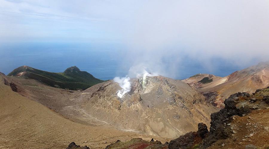
Sarychev Volcano (Last eruption: 2009).
Stratovolcano of the somma-vesuvius type on the island of Matua of the Greater Kuril Ridge; one of the most active volcanoes of the Kuril Islands. The absolute height is 1446 m. The strongest volcanic activity occurred from 12 to 15 June 2009. It manifested itself in the gathering of pyroclastic flows, pyroclastic waves, and outflow of lava flows. Pyroclastic flows reached the sea and in some places its coast receded by 400 meters. These flows covered snowfields in the southeastern part of the volcano, which caused intense snowmelt and, as a result, lahars. As a result of this eruption, the area of the island increased by 1.5 sq. km, and the surface of the volcano sank by 40 mm and moved to the north by about 30 mm. For areas up to 30 sq. km vegetation has died.
Ebeko (Last eruption: 2010).
Complex stratovolcano with several summit craters. Located in the north of the island; in the northern part of the Vernadsky Ridge. The absolute height is 1156 m. One of the most active volcanoes of the Kuril Islands. During an eruption in September 1859, thick sulfuric fumes covered the neighboring island of Shumshu, causing nausea and headaches among the inhabitants.
Plosky Tolbachik (Last eruption: 2012).
Tolbachiksky is a volcanic massif in the east of Kamchatka, in the southwestern part of the Klyuchevskaya group of volcanoes. It includes Ostry Tolbachik (3682 m) and Plosky Tolbachik (3140 m), located on the pedestal of an ancient shield volcano. A new fissure eruption began on November 27, 2012 with the opening of a fissure about 5 km long, a few kilometers south of the caldera. The lava flow of the South Center flooded the IV&S FEB RAS station located at the foot of the volcano (the former base "Leningradskaya"), as well as the building of the base of the natural park "Volcanoes of Kamchatka".
Kizimen (Last eruption: 2013).
Located on the western slope of the southern tip of the Tumrok ridge, 115 km from the village of Milkovo, 265 km from the city of Petropavlovsk-Kamchatsky. The absolute height is 2376 m. During the eruption in 2009, some geysers became more active in the valley of geysers. Before the eruption, there was an extrusive lava plug in the crater. On May 3, 2009 at 9:00 am, Kizimen became more active and the lava plug literally split into small volcanic rocks, as a result of which the ash scattered over most of the Kronotsky Biosphere Reserve.
Nameless (Last eruption: 2013).
Volcano in Kamchatka, near Klyuchevskaya Sopka, about 40 km from the village of Klyuchi, Ust-Kamchatsky region. The absolute height of this volcano is 2882 m. The most famous Bezymyanny eruption occurred in 1955-1956. The height of the eruption cloud reached a height of about 35 km. As a result of the eruption, a horseshoe-shaped crater with a diameter of 1.3 km was formed, open to the east. At the eastern foot of the volcano on an area of 500 sq. km trees and shrubs were broken and knocked down in the direction from the volcano.
Klyuchevskaya Sopka (Last eruption: 2013).
Stratovolcano in the east of Kamchatka. It is the highest active volcano on the Eurasian continent. The age of the volcano is approximately 7000 years, and its height varies from 4750 to 4850 m and more above sea level. The last eruption began on August 15, 2013. On August 26, the first lava flow was recorded on the southwestern slope of the volcano, followed by four lava flows. On October 15-20, the culminating phase of the volcanic eruption was observed with the rise of the ash column up to 10-12 km. The ash plume stretches southwest of Klyuchevskoy volcano. Ashfall took place in the villages of Lazo and Atlasovo, the thickness of the fallen ash is about two millimeters.
Karymskaya Sopka (Last eruption: 2014).
The volcano is located in Kamchatka, within the Eastern Range. Refers to stratovolcanoes. The absolute height is 1468 m. A very active volcano, more than 20 eruptions have been recorded since 1852. Near Karymskaya Sopka, in the caldera of a nearby ancient volcano, there is Karymskoye Lake. With a powerful underwater explosion in 1996, almost all living things died in the lake.
Shiveluch (Last eruption: March 2015).
Volcano on the Kamchatka Peninsula within the Eastern Range. The northernmost active volcano in Kamchatka. The absolute height is 3307 m. On June 27, 2013, early in the morning, Shiveluch threw out a column of ash up to 10 km above sea level, in the village of Klyuchi located 47 km from the volcano, an ash fall took place, the streets of the village were powdered with a layer of red ash up to a millimeter thick. On October 18, following the Klyuchevskaya Sopka volcano, Shiveluch threw out a column of ash 7600 meters high. February 7, 2014 threw a column of ash over 11,000 meters high. On May 13, 2014, the volcano threw out three columns of ash to a height of 7 to 10 km.
Incredible Facts
In mid-June of this year, it was 20 years since the catastrophic eruption of Mount Pinatubo, as a result of which a huge amount of ash was released into the atmosphere and circled the globe, which led to a drop in global temperatures by 0.5 degrees Celsius next year.
On this anniversary, we decided to highlight the largest volcanic eruptions as measured by the Volcanic Eruption Index (VEI), a classification system similar to earthquakes.
The system was developed in the 1980s, taking into account factors such as the volume of the eruption, its speed, and other quantitative variables. The scale ranges from 1 to 8, with each subsequent VEI being 10 times stronger than the previous one.
There have been no volcanic eruptions with an index of 8 in the last 10,000 years, however, human history has witnessed several powerful and destructive eruptions. Below are the 10 most powerful volcanic eruptions that have occurred in the last 4000 years.
Huaynaputina, Peru - 1600, VEI 6
 It was the largest volcanic eruption of all time in the history of South America. The explosion provoked the appearance of mudflows that reached the Pacific Ocean, which was located 120 km from the scene. Among other things, apparently, the explosion also affected the global climate. The summer of 1600 was one of the coldest in the previous 500 years. Ash from the explosion covered everything around within a radius of 50 square kilometers.
Despite the fact that the mountain is quite high (4850 meters), no one expected an eruption from it. She stands on the edge of a deep canyon, and her peak does not at all resemble the silhouette that is usually associated with possible eruptions. The cataclysm of 1600 damaged the nearby cities of Arequipa and Moquegau, which did not recover until a century later.
Krakatoa (Krakatoa), Sunda Strait, Indonesia, - 1883, VEI 6
 The most powerful explosion that occurred on August 26-27, 1883 was accompanied by loud peals for several months. The eruption of this stratovolcano, located along a volcanic island arc in the subduction zone of the Indo-Australian Platform, threw out huge amounts of rock, ash and pumice, and it was heard for thousands of kilometers.
The explosion also provoked the development of a tsunami, the maximum wave height reached 40 meters, while more than 34,000 people died. Tidal sensors located 11,000 km from the Arabian Peninsula even recorded an increase in wave height.
While the island that had been his home before the eruption of Krakatoa remained completely destroyed, new eruptions began in December 1927 and provoked the appearance of Anak Krakatoa ("Child of Krakatoa"), a cone in the center of the caldera that appeared as a result of the 1883 eruption. Anak Krakatau comes to his senses from time to time, reminding everyone of his great parent.
Volcano Santa Maria, Guatemala - 1902, VEI 6
 The Santa Maria eruption in 1902 was one of the largest eruptions of the 20th century. A strong explosion occurred after almost 500 years of silence, leaving behind a large crater, about 1.5 km in diameter, on the southwestern flank of the mountain.
The symmetrical, tree-covered volcano is part of a chain of stratovolcanoes that rises along the Pacific plain of the coast of Guatemala. From the moment of the strongest explosion, the volcano began to show its character too often. So, in 1922 there was an eruption with a force of VEI 3, and in 1929 Santa Maria "gave out" a pyroclastic flow (fast moving and flammable clouds of gas and dust) that killed more than 5,000 people.
Novarupta, Alaska Peninsula - June 1912, VEI 6
 The eruption of Novarupta - one of the chain of volcanoes in the Alaska Peninsula, part of the Pacific ring of fire - was the largest volcanic explosion of the 20th century. A powerful eruption provoked the release of 12.5 cubic kilometers of magma and ash into the air, which then settled on the ground in a radius of 7800 square kilometers.
Mount Pinatubo, Luzon, Philippines - 1991, VEI 6
 The catastrophic eruption of Pinatubo was a classic explosive eruption. The eruption spewed more than 5 cubic kilometers of waste products into the air and created a column of ash that rose 35 kilometers into the atmosphere. Then all this fell on one village, the roofs of many of whose houses even collapsed under the weight of ash.
The explosion also released several million tons of sulfur dioxide and other elements into the air, which spread around the world due to air currents and caused a global drop in temperature by 0.5 degrees Celsius next year.
Ambrym Island, Republic of Vanuatu - 50 AD, VEI 6+
 The 665 sq. km volcanic island, which is part of a tiny country in the southwestern Pacific Ocean, witnessed one of the most impressive eruptions in the history of mankind, when a huge amount of ash and ash was thrown into the atmosphere and a caldera 12 km in diameter was formed .
The volcano continues to be one of the most active in the world to this day. It has erupted about 50 times since 1774, and has proven to be the most dangerous neighbor for people living nearby. In 1894, six people died as a result of being hit by volcanic bombs, and four people drowned in lava flows. In 1979, acid rain, triggered by a volcanic eruption, burned several local residents.
Ilopango Volcano, El Salvador - 450 AD, VEI 6+
 Although this mountain is located in the center of El Salvador, just a few miles east of the capital San Salvador, it has experienced only two eruptions in its history, the first being very strong. It covered much of Central and Western El Salvador in cinders and ash, and destroyed the early Maya cities, forcing the inhabitants to flee.
Trade routes were destroyed, and the center of Maya civilization moved from the mountainous regions of El Salvador to the lowlands in the north in Guatemala. Eruption calderas are currently one of the largest lakes in El Salvador.
Mount Thera, Santorini Island, Greece - 1610 BC, VEI 7
 Geologists believe that the volcano of the Aegean islands of Thera exploded with a force equivalent to the force of several hundred atomic bombs. Although there is no record of an eruption, geologists think it was the most violent explosion ever seen by man.
The island of Santorini (part of the archipelago of volcanic islands) where the volcano is located was home to the people of the Minoan civilization, although there are some indications that the inhabitants of the island suspected the "desire" of the volcano to explode and were able to evacuate in time. But even if we assume that the inhabitants managed to escape, as a result of the eruption, their culture still suffered greatly. It is also worth noting that the volcano provoked the strongest tsunami, and the huge release of sulfur dioxide into the atmosphere caused a global decrease in temperature and climate change subsequently.
Changbaishan volcano, China-North Korea border, 1000, VEI 7
 Also known as the Baitoushan Volcano, its eruption ejected so much volcanic material that even northern Japan, 1,200 km away, felt it. The eruption created a large caldera - almost 4.5 km in diameter and about 1 km deep. Currently, the caldera is Lake Tianchi, which is popular with tourists not only for its beauty, but also because of the alleged unidentified creatures living in its depths.
The mountain last erupted in 1702 and geologists believe it is dormant. Emissions of gases were recorded in 1994, but no evidence of the resumption of activity of the volcano was observed.
Mount Tambora, Sumbawa Island, Indonesia - 1815, VEI 7
 The explosion of Mount Tambora is the largest in the history of mankind, its explosive index is 7, which is a very high figure. The volcano, which is still active, is one of the highest peaks in the Indonesian archipelago. The eruption reached its peak in April 1815, the explosion was so loud that it could be heard on the island of Sumatra, which is located at a distance of more than 1930 km. The death toll was 71,000, and clouds of heavy ash hit many islands very far from the volcano.
In fact, volcanoes have shaped the face of the Earth for millions of years. Here are the most serious volcano-related disasters in human history.
№8 . Experts believe that the largest volcanic eruption that occurred at the dawn of mankind happened in Sumatra: the volcano Toba erupted 71,000 years ago. Then about 2800 cubic meters were thrown into the atmosphere. km of ash, which could reduce the human population worldwide to just 10,000 people.
№7. Eruption El Chichon was not particularly large (5 on the VEI scale), with a maximum height of the eruptive column of 29 km. But there was a lot of sulfur in the cloud. In less than one month it circled the globe, but half a year passed before it spread to 30°N. ts, practically not spreading to the Southern Hemisphere. Samples collected from airplanes and balloons showed that the cloud particles were mostly tiny glass beads coated with sulfuric acid. Gradually sticking together, they quickly settled on the ground, and after a year the mass of the remaining cloud was reduced to about Oz from the original. The absorption of sunlight by cloud particles warmed the equatorial stratosphere by 4° in June 1982, but at ground level in the Northern Hemisphere the temperature dropped by 0.4°.
№6. Lucky , volcano in Iceland. Laki is a chain of more than 110-115 craters up to 818 m high, stretching for 25 km, centered on the Grímsvotn volcano and including the Eldgja canyon and the Katla volcano. In 1783-1784, a powerful (6 points on the eruption scale) fissure eruption occurred on Lucky and the neighboring Grimsvotn volcano, with the release of about 15 km³ of basalt lava within 8 months. The length of the lava flow that poured out of the 25-kilometer crack exceeded 130 km, and the area filled by it was 565 km². Clouds of poisonous fluorine and sulfur dioxide compounds rose into the air, killing more than 50% of Iceland's livestock; volcanic ash partially or completely covered pastures in most of the island. Huge masses of ice, melted by lava, led to large-scale floods. Famine began, resulting in the death of approximately 10 thousand people, or 20% of the country's population. This eruption is considered one of the most destructive in the last millennium and the largest lava eruption in history. Fine ash erupted by the volcano was present in the second half of 1783 over most of the territory of Eurasia. The decrease in temperature in the northern hemisphere caused by the eruption led in 1784 to crop failure and famine in Europe.
№5. eruption Vesuvius, perhaps the most famous eruption in the world. Vesuvius (Italian Vesuvio, Neap. Vesuvio) is an active volcano in southern Italy, about 15 km from Naples. Located on the coast of the Gulf of Naples in the province of Naples, Campania region. Included in the Apennine mountain system, has a height of 1281 m.

The disaster claimed the lives of 10,000 people and destroyed the cities of Pompeii and Herculaneum.
№4 . In 1883 there was a catastrophic volcanic eruption Krakatoa, which destroyed most of the island of the same name.
The eruption began in May. Until the end of August, a significant amount of rock was carried out by explosions, which led to the devastation of the "underground chamber" under Krakatoa. The last powerful explosion of the pre-climax occurred at dawn on August 27. The ash column reached a height of 30 km. On August 28, most of the island, under its own weight and the pressure of the water column, collapsed into voids below sea level, dragging along a huge mass of ocean water, the contact of which with magma caused a strong hydromagmatic explosion.
A significant part of the volcanic structure scattered within a radius of up to 500 km. Such a range of expansion was ensured by the rise of magma and rocks into the rarefied layers of the atmosphere, to a height of up to 55 km. The gas-ash column rose into the mesosphere, to a height of over 70 km. Ash fall occurred in the eastern Indian Ocean over an area of over 4 million km². The volume of material ejected by the explosion was about 18 km³. The force of the explosion (6 points on the eruption scale), according to geologists, was at least 200 thousand times greater than the force of the explosion that destroyed Hiroshima.
The roar of the explosion was clearly audible within a radius of 4,000 km. On the coast of Sumatra and Java, the noise level, according to scientists, reached 180 decibels or more.
A significant amount of volcanic ash remained in the atmosphere at altitudes up to 80 km for several years and caused intense coloration of dawns.
Tsunamis up to 30 meters high caused the death of about 36 thousand people on neighboring islands, 295 cities and villages were washed into the sea. Many of them, before the tsunami approach, were probably destroyed by an air wave that toppled the equatorial forests on the coast of the Sunda Strait and tore roofs off houses and doors from their hinges in Jakarta at a distance of 150 km from the crash site. The atmosphere of the entire Earth was perturbed by the explosion for several days. The air wave went around the Earth according to various sources from 7 to 11 times.
№3 . For a long time, people considered the Colombian volcano Ruiz if not extinct, then at least dormant. They had good reason: the last time this volcano erupted in 1595, and then for almost five centuries did not show signs of activity.
The first signs of the awakening of Ruiz became noticeable on November 12, 1985, when ash began to erupt from the crater. At 9 pm on November 13, several explosions thundered, and a full-scale eruption began. The height of the column of smoke and rock fragments thrown out by explosions reached 8 meters. Due to the outpouring of lava and the release of hot gases, the temperature increased, as a result of which the snow and ice covering the volcano melted. Late in the evening, the mudflow reached the city of Armero located 40 kilometers from the volcano and actually wiped it off the face of the earth. Several surrounding villages were also destroyed. Oil pipelines and power lines were damaged, bridges were destroyed. Communication with the affected area was interrupted due to broken telephone lines and erosion of roads.
According to official figures from the Colombian government, about 23,000 people died or went missing as a result of the eruption, and another 5,000 were seriously injured and maimed. Tens of thousands of Colombians lost their homes and property. Coffee plantations were seriously damaged by the eruption: not only the coffee trees themselves were destroyed, but also a significant part of the already harvested crop. The Colombian economy has suffered significant damage.
№2. Mont Pelee . This eruption, which occurred in 1902 on the island of Martinique, became the strongest in the 20th century. Residents of the city of Saint-Pierre, located in Martinique, located just 8 kilometers from the Mont Pele volcano, are accustomed to considering this mountain a peaceful neighbor. And, since the last eruption of this volcano, which happened in 1851, was very weak, they did not pay much attention to the tremors and rumble that began at the end of April 1902. By May, the activity of the volcano intensified, and on May 8, one of the worst natural disasters of the 20th century broke out.

Around 8 o'clock in the morning began the eruption of Mont Pele. A cloud of ash and stones was thrown into the air, and a stream of lava rushed towards the city. However, it was not the ash and lava that turned out to be the most terrible, but the hot volcanic gases that swept through Saint-Pierre at great speed, causing fires. Desperate people tried to escape on ships standing in the port, but only the steamer Roddan managed to go to sea. Unfortunately, almost all of its crew and passengers died due to burns, only the captain and engineer survived.
As a result of the volcanic eruption, the city of Saint-Pierre was almost completely destroyed, and all the people and animals that were in it died. The eruption of Mont Pele claimed the lives of more than 30 thousand people; of the inhabitants of the city, only the criminal who was in the underground prison could remain alive.
Currently, Saint-Pierre has been partially restored, and a museum of volcanology has been built at the foot of Mont Pele.
№1 Tambora
The first signs of the awakening of the volcano became noticeable as early as 1812, when the first jets of smoke appeared above the top of Tambora. Gradually, the amount of smoke increased, it became denser and darker. April 5, 1815 there was a strong explosion, and an eruption began. The noise produced by the volcano was so strong that it was heard even 1,400 kilometers from the scene. The tons of sand and volcanic dust thrown out by Tambora covered the entire area with a thick layer within a radius of one hundred kilometers. Under the weight of ash, residential buildings collapsed not only on the island of Sumbawa, but also on neighboring islands. Ashes even reached the island of Borneo, located 750 kilometers from Tambora. The amount of smoke and dust in the air was so great that within a radius of 500 kilometers from the volcano it was night for three days. According to eyewitnesses, they saw nothing further than their own hand.
This terrible eruption, which lasted about 10 days, according to the most conservative estimates, claimed the lives of 50 thousand people. There are data according to which the death toll exceeded 90 thousand. Almost the entire population of Sumbawa was destroyed, and the inhabitants of neighboring islands suffered severely both from the ejection of ash and huge stones, and from starvation, which was the result of the destruction of fields and livestock.
Due to the eruption of Tambora, a huge amount of ash and dust accumulated in the Earth's atmosphere, and this had a significant impact on the climate of the entire planet. The year 1816 went down in history as "the year without a summer". Due to unusually low temperatures on the east coast of North America and in Europe this year there were crop failures and famine. In some countries, the snow stayed for most of the summer, and in New York and the northeastern United States, the thickness of the snow cover reached a meter. The effect of this volcanic winter gives an idea of one of the consequences of a possible atomic war - nuclear winter.

10 largest and most dangerous volcanoes on Earth.
A volcano is a geological formation that arose due to the movement of tectonic plates, their collision and the formation of faults. As a result of collisions of tectonic plates, faults are formed, and magma comes to the surface of the Earth. As a rule, volcanoes are a mountain, at the tip of which there is a crater, which is the place where the lava comes out.
Volcanoes are divided into:
- operating;
- sleeping;
- extinct;
Active volcanoes are those that have erupted in the short term (approximately 12,000 years)
Dormant volcanoes are called volcanoes that have not erupted in the near historical perspective, but their eruption is practically possible.
Extinct volcanoes include those that have not erupted in the near historical future, however, the top has the shape of a crater, but such volcanoes are unlikely to erupt.
List of the 10 most dangerous volcanoes in the world:
1. (Hawaii, USA)
Located in the islands of Hawaii, it is one of the five volcanoes that make up the islands of Hawaii. It is the largest volcano in the world in terms of volume. It contains over 32 cubic kilometers of magma.
The volcano formed about 700,000 years ago.
The last volcanic eruption occurred in March 1984, and it lasted more than 24 days, causing great damage to people and the surrounding area.
2. Taal Volcano (Philippines)

The volcano is located on the island of Luzon, belonging to the Philippine Islands. The crater of the volcano rises 350 meters above the surface of Lake Taal and is located almost in the center of the lake.
The peculiarity of this volcano is that it is located in the crater of a very old extinct mega volcano, now this crater is filled with lake water.
In 1911, the most powerful eruption of this volcano occurred - then 1335 people died, within 10 minutes all life around the volcano died at a distance of 10 km.
The last eruption of this volcano was observed in 1965, which led to 200 human casualties.
3. Merapi Volcano (Java Island)
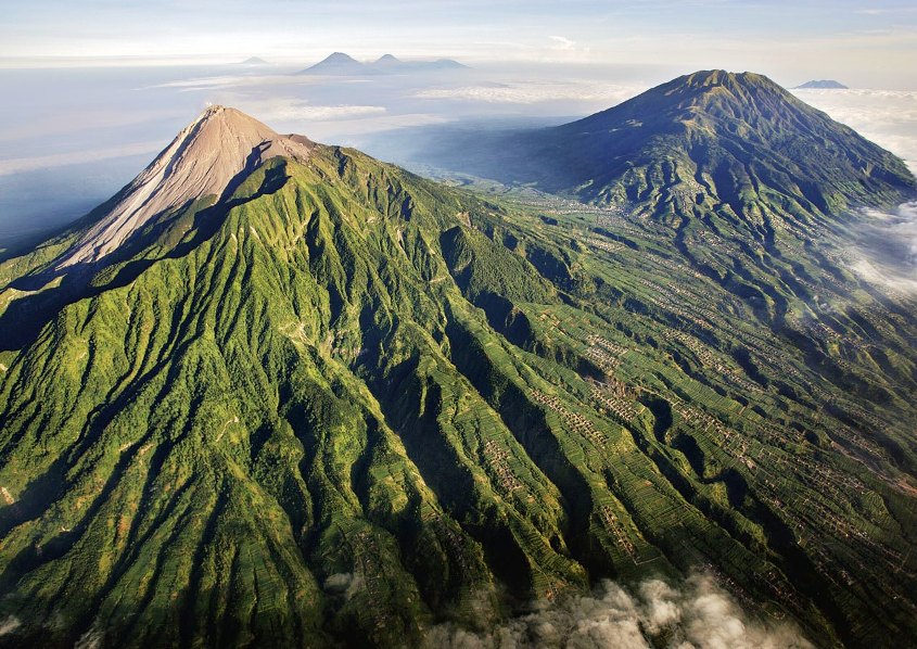
The name of the volcano in the literal sense is the Mountain of Fire. The volcano has been systematically erupting over the past 10,000 years. The volcano is located near the city of Yogyakarta, Indonesia, the population of the city is several thousand people.
It was the most active volcano among the 130 volcanoes in Indonesia. It was believed that the eruption of this volcano led to the decline of the Hindu Kingdom of Matarama. The peculiarity and horror of this volcano is the speed of magma propagation, which is more than 150 km / h. The last volcanic eruption occurred in 2006 and claimed 130 lives and made more than 300,000 people homeless.
4. Santa Maria Volcano (Guatemala)

It is one of the most active volcanoes of the 20th century.
It is located at a distance of 130 kilometers from the city of Guatemala, and is located in the so-called Pacific. Ring of Fire. The Santa Maria crater was formed after it erupted in 1902. About 6,000 people died then. The last eruption occurred in March 2011.
5. Volcano Ulawun (Papua New Guinea)

Ulawun volcano, located in the region of New Guinea, began to erupt from the beginning of the 18th century. Since then, eruptions have been recorded 22 times.
In 1980, the largest volcanic eruption occurred. The ejected ash covered an area of more than 20 square kilometers.
Now this volcano is the highest peak in the region.
The last volcanic eruption occurred in the year 2010.
6. Volcano Galeras (Colombia)

The Galeras volcano is located near the border of Ecuador in Colombia. One of the most active volcanoes in Colombia, it has been systematically erupting over the past 1000 years.
The first documented volcanic eruption occurred in 1580. This volcano is considered the most dangerous because of its sudden eruptions. Along the eastern slope of the volcano is the city of Paphos (Pasto). Paphos is a residence for 450,000 people.
In 1993, six seismologists and three tourists died during a volcanic eruption.
Since then, the volcano has erupted every year, claiming thousands of lives and making many people homeless. The last volcanic eruption occurred in January 2010.
7. Volcano Sakurajima (Japan)

Until 1914, this volcanic mountain was located on a separate island in the immediate vicinity of Kyushu. After a volcanic eruption in 1914, a lava flow connected the mountain to the Ozumi Peninsula (Japan). The volcano was named as Vesuvius of the East.
It serves as a threat to the 700,000 people of Kagoshima City.
Since the year 1955, eruptions have occurred every year.
The government even built a refugee camp for the people of Kagoshima so they could find shelter during the volcanic eruption.
The last volcanic eruption occurred on August 18, 2013.
8. Nyiragongo (DR Congo)
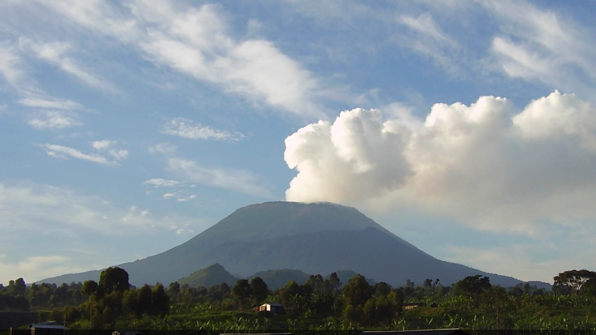
It is one of the most active, active volcanoes in the African region. The volcano is located in the Democratic Republic of the Congo. The volcano has been monitored since 1882. Since the beginning of observations, 34 eruptions have been recorded.
The crater in the mountain serves as a holder for the magma fluid. In 1977, there was a major eruption, neighboring villages were burned by hot lava flows. The average speed of the lava flow was 60 kilometers per hour. Hundreds of people died. The most recent eruption occurred in the year 2002, leaving 120,000 people homeless.

This volcano is a caldera - the formation of a pronounced rounded shape with a flat bottom.
The volcano is located in the Yellow National Park of the United States.
This volcano has not erupted for 640,000 years.
The question arises: How can it be an active volcano?
There are claims that 640,000 years ago, this super volcano erupted.
This eruption changed the terrain and covered half of the US in ash.
According to various estimates, the volcanic eruption cycle is 700,000 - 600,000 years. Scientists expect this volcano to erupt at any time.
This volcano could destroy life on Earth.
Most of the volcanoes on our planet are located in the "ring of fire", which stretches along the shores of the entire Pacific Ocean. And in total there are about 1.5 thousand volcanoes on Earth, of which 540 are active.
Here is a list of the most dangerous ones.
1. Nyiragongo, height 3470 m, Democratic Republic of the Congo
This is one of the most dangerous volcanoes in Africa. Since 1882, 34 eruptions have been recorded here. The main crater is 250 meters deep and 2 km wide, and contains a lake of actively bubbling lava. This lava is unusually fluid and its flows can reach speeds of 100 km/h. In 2002, the eruption killed 147 people and left 120,000 homeless. The last eruption to date occurred in 2016.
2. Taal, height 311 m, Philippines
This is one of the smallest active volcanoes on our planet. It has erupted 34 times since 1572. Located on the island of Luzon, on Lake Taal. The strongest eruption of this volcano in the 20th century occurred in 1911 - 1335 people died in 10 minutes and in general all living things at a distance of up to 10 km. In 1965, 200 people died. Last eruption - 1977
3. Mauna Loa, height 4169 m, Hawaii (USA)
There are many volcanoes in Hawaii, but this is the largest and most dangerous of all. Since 1832, 39 eruptions have been recorded. The last eruption occurred in 1984, the last strong eruption in 1950.
4. Vesuvius, height 1281 m, Italy
One of the most dangerous volcanoes in the world is located just 15 km east of Naples. The most famous historical eruption occurred in 79 AD. As a result of this catastrophe, two cities - Pompeii and Herculaneum - disappeared from the face of the Earth. In modern history, the last eruption of Vesuvius happened in 1944.
5. Merapi, height 2,930 m, Indonesia
This most active active volcano in Indonesia is located on the island of Java near the city of Yogyakarta. "Merapi" is translated as "mountain of fire". The volcano is young, so it puffs with enviable regularity. Large eruptions occur on average every 7 years. In 1930, about 1300 people died, in 1974 two villages were destroyed, in 2010 353 people died. Last eruption - 2011
6. St. Helens, height 2,550 m, USA
Located 154 km from Seattle and 85 km from Portland. The most famous eruption of this active volcano occurred in 1980, when 57 people died. The eruption was of a rare type - "directed explosion". The process of the volcanic eruption and the spread of the ash cloud was photographed by photographer Robert Landsburg, who died during this eruption, but kept the film. The last activity to date was recorded in 2008.
7. Etna, height 3,350 m, Italy
Mount Etna is located on the east coast of Sicily. It is the highest active volcano in Europe. During its existence, it erupted about 200 times. In 1992, one of the largest eruptions was recorded, during which the town of Zafferana barely escaped. On December 3, 2015, the central crater of the volcano threw a fountain of lava to a kilometer high. The last eruption is February 27, 2017.
8. Sakurajima, height 1117 m, Japan
The volcano is located on the Osumi Peninsula of Kyushu Island in the Japanese prefecture of Kagoshima. There is almost always a cloud of smoke above the volcano. The eruptions were recorded on August 18, 2013, in March 2009. The last eruption was recorded on July 26, 2016.
9. Galeras, height 4276 m, Colombia
Over the past 7 thousand years, at least six large eruptions and many small ones have occurred on Galeras. In 1993, during research work in the crater, six volcanologists and three tourists died (then the eruption also began). Latest recorded eruptions: January 2008, February 2009, January and August 2010
10. Popocatepetl, height 5426 m, Mexico
The name translates as "smoking hill". The volcano is located near Mexico City. It has erupted 20 times since 1519. The last eruption was recorded in 2015.
11. Unzen, height 1,500 m, Japan
The volcano is located on the Shimabara Peninsula. The eruption of Mount Unzen in 1792 is one of the five most destructive eruptions in human history in terms of the number of human casualties. The eruption caused a tsunami 55 meters high, which killed more than 15 thousand people. And in 1991, 43 people died during the eruption. No eruptions have been observed since 1996.
12. Krakatoa, height 813 m, Indonesia 
This active volcano is located between the islands of Java and Sumatra. Before the historic eruption of 1883, the volcano was much higher and was one large island. However, the most powerful eruption of 1883 destroyed the island and the volcano. Today, Krakatau is still active and small eruptions occur fairly regularly. Last activity - 2014.
13. Santa Maria, height 3,772 m, Guatemala
The first recorded eruption of this volcano occurred in October 1902, before that he "rested" for 500 years. The explosion was heard 800 km away in Costa Rica, and the ash column rose 28 km. About 6 thousand people died. Today the volcano is active. The last eruption was registered in 2011.
14. Klyuchevskaya Sopka, height 4835 m, Russia
The volcano is located in the east of Kamchatka, 60 km from the coast. It is the largest active volcano in Russia. Over the past 270 years, more than 50 eruptions have been recorded, the last in April 2016.
15. Karymskaya Sopka, height 1468 m, Russia
Also located in Kamchatka. More than 20 eruptions have been recorded since 1852. Eruptions of recent years: 2005, 2010, 2011, 2013, 2014, 2015 A very restless volcano.