Major geographical discoveries. The most famous travelers and their discoveries
The main geographical discoveries in the history of mankind were made in the 15th - 17th centuries. This period accounts for a number of important journeys made by Europeans, which led to the opening of new trade routes, lands, and also to the seizure of territories.
As historians call these events, they became possible largely due to the achievements of science and technology. It is in this historical period that reliable sailing ships have been created, navigation and coastal maps and a compass have been improved, the idea of the Earth's sphericity has been substantiated, etc. Africa, Asia Minor and the Mediterranean Sea, which made it difficult to trade with the world of the East.
The discovery and conquest of America is associated with the name of H. Columbus, who discovered the Antilles and Bahamas, and in 1492 - America itself. Amerigo Vespucci sailed to the coast of Brazil as a result of expeditions in 1499-1501.
1497-1499 is the time when Vasco da Gama was able to find a continuous sea route to India from Western Europe along the coast of South Africa. By 1488, the Portuguese navigator, as well as a number of other travelers, made geographical discoveries on the southern and western coast of Africa. The Portuguese also visited the Malacca Peninsula and Japan.
In the period between 1498 and 1502 A. Ojeda, A. Vespucci and other Portuguese and Spanish navigators explored the northern coast of South America, including its eastern (territory of modern Brazil) coast and part of the Caribbean coast of Central America.
Between 1513 and 1525, the Spaniards (V. Nunez de Balboa) managed to cross the Isthmus of Panama and reach the Pacific Ocean. In 1519-1522 Fernand Magellan made the first voyage around the Earth: he entered the Pacific Ocean, circumnavigating South America, and thus proved that the Earth has a spherical shape. The second time, in 1577-1580, it was done by Francis Drake.
The possessions of the Aztecs were conquered by Hernan Cortes in 1519-1521, the Incas - by Francis Pizarro in 1532-1535, the Maya - in 1517-1697, etc.
The geographical discoveries of the British were associated with the search for a northwestern route to Asia, as a result of which they discovered the island of Newfoundland and the coast of North America (1497-1498, J. Cabot), the island of Greenland, etc. (from 1576 to 1616 G. Hudson, W. Baffin and others). French travelers explored the coast of Canada (J. Cartier, 1534-1543), the Great Lakes and the Appalachian mountains (1609-1648, S. Champlain, etc.).
The great travelers of the world began their voyages not only from European ports. There were many Russians among the explorers. These are V. Poyarkov, E. Khabarov, S. Dezhnev and others who explored Siberia and the Far East. Among the pioneers of the Arctic are V. Barents, G. Hudson, J. Davis, W. Baffin and others. The Dutch A. Tasman and V. Janszon became famous for their travels to Australia, Tasmania and New Zealand. In the 18th century (1768), the region was re-examined by James Cook.
The geographical discoveries of the 15th - 17th centuries, as a result of which a significant part of the earth's surface was explored, helped to establish the modern contours of the continents, with the exception of parts of the coasts of America and Australia. A new era in the geographical study of the Earth was opened, which led to serious geopolitical and socio-economic consequences and was important for the further development of a number of natural sciences.
The discovery of new lands, countries, trade routes contributed to the further development of trade, industry and relations between states. This led to the beginning of the formation of the world market and the era of colonialism. The development of the Indian civilizations of the New World was artificially interrupted.
The geographical discoveries of the late 15th - mid-17th centuries, when the Europeans began to actively explore the "new" regions of the Earth, played an important role in the decomposition of feudalism and the genesis of capitalism. The discoveries of this period are usually called Great due to their exceptional significance for the destinies of Europe and the whole world.
The Age of Discoveries is divided into two periods:
The Spanish-Portuguese period (late 15th century - mid-16th century), which included the discovery of America (the first expedition of Columbus in 1492); Portuguese voyages to India and the shores of East Asia, starting with the Vasco de Gama expedition; Spanish Pacific expeditions of the 16th century. from Magellan's first circumnavigation of the world to the Villalovos expedition (1542-1543).
The period of Russian and Dutch discoveries (mid-16th - mid-17th century). These include: the discovery by the Russians of all of North Asia (from the Yermak campaign to the Popov-Dezhnev voyage in 1648); English and French discoveries in North America; Dutch Pacific expeditions and the discovery of Australia.
In the second half of the 15th century. feudalism in Western Europe was at the stage of decay. Large cities grew, trade developed. Money has become a universal medium of exchange, the need for which has sharply increased. In Europe, the demand for gold increased greatly, which intensified the desire for "India - the homeland of spices", where, according to Europeans, there was a lot of gold, silver, gems and spices. But the path to India became inaccessible for the Europeans as a result of the Turkish conquests in Asia Minor and Syria. The monopoly of Italian merchants in European trade in oriental goods pumped gold from Europe to the East. The shortage of the precious metal hampered the development of trade and commodity production in Western European countries. Portugal was the first to start looking for southern sea routes to India. Having won back its territory from the Arabs in the XIII century, continuing the wars with the Arabs in North Africa in the XIV-XV centuries, Portugal created a strong fleet. Already in the 20s and 30s of the 15th century. the Portuguese discovered the island of Madeira and the Azores, and moved far south along the west coast of Africa. The discovery in 1486 of the Cape of Good Hope on the southern tip of Africa created a real opportunity for preparing an expedition to India.
One of the most important reasons for the activity of Portugal, and then Spain in geographical discoveries, was the crisis of the feudal economic system, expressed in the fragmentation of feudal possessions and the ruin of the feudal lords. The Portuguese and Spanish nobles, with contempt for all activities except war, after the victory over the Moors were left idle and very soon found themselves in debt to the usurers. They dreamed of land holdings overseas, but even more of gold and jewelry to pay off the usurers.
Another reason for the overseas expansion was the interest of the strengthened royal power, which dreamed of increasing revenues for the treasury. The urban bourgeoisie and the church were equally interested in the new lands. The bourgeoisie strove to expand the sources of primitive accumulation; the church - to expand its influence in pagan countries. The desire for profit was covered by religious fanaticism - a familiar and convenient mask, under which the desire for power and personal gain was hidden.
Opportunities for long journeys were created by advances in science and technology, the development of shipbuilding and navigation. Since the beginning of the XVI century. the compass is in general use, which, in combination with the astrolabe, played an important role in the development of navigation. The ancient idea of the sphericity of the earth was revived. In the XV century. a caravel designed for ocean navigation was created - a high-speed vessel with spacious holds. The improvement of firearms was of great importance. Until the end of the 15th century. ahead of other countries were the Portuguese. The knowledge they received gave the sailors of other countries new information about sea tides, low tides, currents, and the direction of the winds. Mapping new lands pushed the development of cartography.
From the end of the 15th century. the Spaniards began to search for sea trade routes to India. In 1492 the Genoese navigator Christopher Columbus (1451 - 1506) arrived at the court of the Spanish kings. Columbus offered the Spanish monarchs his project - to reach the shores of India, sailing west across the Atlantic. Prior to this, Columbus proposed his plan to the kings of other countries, but was refused. France and England did not have the necessary funds and navy. The Portuguese by this time were already close to opening the way to India around Africa and did not need someone else's services. In Spain, a more favorable environment has emerged for the implementation of Columbus's plans. After the conquest of Granada in 1492 and the end of the last war with the Arabs, the economic situation of the Spanish monarchy was very difficult. The treasury was empty, the crown no longer had free land at its disposal for sale, and revenue from taxes on trade and industry was insignificant. A huge number of nobles were left without a livelihood. Moreover, the Spanish industry needed markets. All these circumstances turned out to be decisive for the adoption of the Columbus project by the Spanish court. The idea of an overseas expedition was supported by the top of the Catholic Church. A treaty was concluded between the Spanish king and Columbus, according to which the great navigator was appointed viceroy of the newly discovered lands, received the rank of admiral, the right to 1/10 of the income from new possessions and 1/8 of the profits from trade.
On August 3, 1492, a flotilla of three caravels sailed from the harbor of Paloe, heading southwest. On October 12, 1492, the ships approached the Bahamas. Later, the island of Cuba was discovered and its northern coast was explored. Having mistaken Cuba for one of the islands off the coast of Japan, Columbus continued sailing westward and discovered the island of Haiti, which had more gold than the already discovered islands. Off the coast of Haiti, Columbus lost his largest ship and was forced to leave part of the crew on the island. A fort was built here. Fortress Navidad was the first Spanish settlement in the New World.
In 1493 Columbus returned to Spain, where he was received with great honor. Columbus' discoveries worried the Portuguese. In 1494, through the mediation of the Pope, an agreement was concluded, according to which Spain was transferred the right to own lands to the west of the Azores, and Portugal to the east.
Columbus made three more trips to America, during which the Lesser Antilles, Puerto Rico, Jamaica were discovered, the coast of Central America was explored. Until the end of his days, Columbus believed that he had found the western route to India. In 1500 Columbus was accused of abuse of power and sent to Spain in shackles. However, the appearance in Spain of the famous navigator in chains caused outrage. Columbus was soon rehabilitated.
By 1502-1503. refers to the fourth voyage of Columbus to the New World with the aim of finding an outlet to the Indian Ocean and making a round-the-world trip. During this last voyage, Columbus discovered the coast of the mainland south of Cuba, surveyed the southwestern shores of the Caribbean Sea.
Two weeks after the return of Columbus, Queen Isabella, who patronized him, died. He lost support at court. Columbus died in 1506, forgotten by all in complete poverty.
The tragic fate of Columbus is largely due to the successes of the Portuguese. In 1497, Vasco da Gama's expedition was sent to explore the sea route to India around Africa. Having rounded the Cape of Good Hope, the Portuguese sailors entered the Indian Ocean and in May 1498 reached the Indian port of Calicut. Having bought a large load of spices, the expedition set off on the return journey.
The success of Vasco da Gama's expedition made a huge impression in Europe. The Portuguese were faced with tremendous opportunities for the commercial exploitation of India. Thanks to their superiority in weapons and naval technology, they managed to oust Arab merchants from the Indian Ocean and seize all maritime trade with India, and then Malacca and Indonesia. Attempts by the Arabs to oust the Portuguese from the Indian Ocean were unsuccessful.
In India, the Portuguese did not seize vast territories, but sought to seize only strongholds on the coast. Gradually, they captured all trade relations between individual areas of the Indian Ocean coast. This trade generated huge profits. Moving further east along the coast, they mastered the transit routes of the spice trade. Trade with India was declared a monopoly by the Portuguese king.
Having seized control of trade with India, the Portuguese stubbornly searched for a western route to this country. At the end of the 15th - beginning of the 16th century. As part of Spanish and Portuguese expeditions, Amerigo Vespucci traveled to the shores of America, who proved that Columbus had discovered not the coast of India, but a new continent, later called America.
Fernando Magellan, a member of the Portuguese expeditions, suggested that India could be reached by moving west and skirting the newly discovered continent from the south. The Spanish government, which at that time did not receive large revenues from the newly discovered lands, reacted with interest to the Magellan project. According to the treaty concluded by the Spanish king with Magellan, the navigator was supposed to sail to the southern tip of the American continent and open the western route to India. He complained about the titles of ruler and governor of the new lands and 1/20 of all income that would go to the treasury.
On September 20, 1519, a squadron of five ships headed west. A month later, the flotilla reached the southern tip of the American continent and for three weeks moved along the strait, which now bears the name of Magellan. On March 6, 1521, the sailors found themselves at three small islands from the Mariana group. Continuing westward, Magellan reached the Philippine Islands, where he died in a skirmish with the natives.
New discoveries have led to an exacerbation of the previous contradictions between Spain and Portugal. For a long time, experts from both countries could not accurately determine the boundaries of the Spanish and Portuguese possessions due to the lack of accurate data on the longitude of the newly discovered islands. In 1529, under a new agreement, Spain renounced its claims to the Philippine Islands. However, for a long time, no one dared to repeat the journey of Magellan, and the path across the Pacific Ocean to the shores of Asia had no practical significance.
In 1510, the conquest of America began - the colonization and development of the interior regions of the continent, the formation of a system of colonial exploitation.
In 1517-1518. the detachments of Hernan de Cordoba and Juan Grimalva faced the most ancient civilization - the Mayan state. By the time the Spaniards arrived, the territory of Yucatan was divided among several city-states. Not only superiority in weaponry, but also internal struggles between the city-states made it easier for the Spaniards to conquer the Maya. The Spaniards learned from local residents that precious metals were brought from the Aztec country. In 1519, a Spanish detachment headed by Hernan Cortes set out to conquer these lands.
The Aztec state stretched from the coast of the Gulf of Mexico to the Pacific Ocean. A large agricultural population lived here, a perfect system of artificial irrigation was created by the labor of many generations, high yields of cotton, corn, vegetables were grown. The economic basis was represented by the neighboring community. The Maya had a system of labor service. The population was used by the state in the construction of palaces, temples, etc. The craft had not yet separated from agriculture; both artisans and farmers lived in the community. A stratum of representatives of the nobility and leaders - the Caciques, who had large plots of land and used the labor of slaves, began to stand out.
Unlike the Maya, the Aztec state achieved significant centralization, gradually making the transition to the hereditary power of the supreme ruler. However, the lack of internal unity, the internecine struggle for power among the representatives of the highest military nobility and the struggle of the conquered tribes against the conquerors facilitated the victory of the Spaniards. Mexico met the expectations of the conquerors. Rich deposits of gold and silver have been found here.
The second stream of colonization came from the Isthmus of Panama to the south of the Pacific coast of America. The conquerors were attracted by the fabulously rich country of Peru. Fertile, densely populated lands stretched here. The population was engaged in agriculture, raised herds of llamas. Since ancient times, the territory of Peru has been inhabited by the Quechua Indians. In the XIV century. one of the Quechuan tribes - the Incas - conquered numerous Indian tribes. By the beginning of the XVI century. the Inca state included part of the territory of Chile and Argentina. The military nobility was formed from the tribe of conquerors. The center of the Inca power was the city of Cuzco. The basic unit of society among the Incas, as well as among the Mayans and Aztecs, was the neighboring community. From the communal lands, the fields of the nobility and elders, which were in the property, were separated. They had the right to transfer these lands by inheritance.
The conquest of the territory of Peru by the Spaniards stretched out for more than 40 years. If at the first stage the conquerors seized the precious metals accumulated in previous times, then from 1530 in Mexico and on the territory of Peru the systematic exploitation of the richest mines began. From that moment on, the character of colonization changed. The conquerors abandoned the economic development of new lands. Everything necessary for the Spanish settlers began to be brought from Europe in exchange for the gold and silver of the New World. The noble, feudal nature of colonization predetermined the fact that the gold and silver of America fell mainly into the hands of the nobility. All conquered lands became the property of the crown. Beginning in 1512, laws were passed prohibiting the enslavement of Indians. Formally, they were considered subjects of the Spanish king, paid a special tax and fulfilled labor service.
In the first half of the XVI century. in general terms, the system of government of the Spanish colonies in America has developed. Colonial trade was placed under the control of the Seville Chamber of Commerce (1503), which carried out customs inspection of all goods, collected duties, and kept emigration processes under supervision. The main industry in the Spanish colonies was mining.
The colonial system that developed in the Portuguese colonies was different from the Spanish one. Since 1500, Brazil has become the main object of colonization, where there was no sedentary agricultural population, and the small Indian tribes, which were at the stage of the tribal system, were pushed into the interior of the country. The lack of deposits of precious metals and significant human resources determined the commercial nature of the initial colonization of Brazil.
Since 1500, the economic development of the coastal regions of Brazil began. The coast was divided into 13 capitals, the owners of which had full power. But Portugal did not have a significant surplus population, so the settlement of the colonies was slow. The absence of migrant peasants and the small number of the indigenous population made it impossible for the development of feudal forms of economy. The most successfully developed areas where a plantation system arose, based on the exploitation of Negro slaves from Africa. Since the second half of the XVI century. the importation of African slaves is growing rapidly. White settlers lived mainly in the coastal zone in closed groups, engaged in trade and crafts.
In the second half of the 16th - early 17th century. Spanish sailors made a number of Pacific expeditions from Peru, during which the Solomon Islands, South Polynesia and Australia were discovered. However, Spain did not have the strength and means to develop new lands. Therefore, the Spanish government for a whole century kept secret all information about the discovery, fearing the rivalry of other powers. Only in the middle of the 17th century. the Dutch began exploring the coast of Australia.
The consequences of the great geographical discoveries. In the first period of the Great Geographical Discoveries, when the main trade routes moved from the Mediterranean Sea to the Atlantic Ocean, Portugal and Spain dominated trade. However, the main producers of manufactured goods were the Netherlands, England and France, which made it possible for the bourgeoisie of these countries to grow rich quickly, pumping gold and silver from the Pyrenean countries in exchange for manufactured goods. Gradually, they drove out competitors from the sea routes, and then from their overseas colonies. After the defeat of the Invincible Armada (1588), the Spanish-Portuguese power (in those years, both Pyrenean powers were a single state) was dealt a crushing blow. In particular, in the studies of the Pacific Ocean and the South Seas at the turn of the 16th and 17th centuries. the initiative passed to the Netherlands, and in the 40s of the XVII century. the bourgeois revolution in England brought this country to the arena of struggle for markets, domination of the seas, colonial possessions.
One of the consequences of the Great Geographical Discoveries was the strengthening of new trends in the economic policy of European absolutism, which acquired a pronounced mercantilist character. The ruling dynasties in Spain, France, England in all available ways encouraged trade, industry, shipping, colonial expansion. Mercantilism was engendered by the developing capitalism, but it also served the interests of the nobility. National industry and trade provided the means to maintain the feudal state, and therefore to preserve the social domination of the nobles.
The opening of new trade routes and previously unknown countries and continents, the establishment of stable ties between Europe and other parts of the world in a relatively short time allowed the European countries to acquire huge resources.
As a result of the Great Geographical Discoveries, a system of colonial domination and colonial exploitation emerged. Initially, the main method of exploitation of the colonies was open robbery. Subsequently, the tax system became widespread. But the main income from the exploitation of the colonies came from trade. The rise of Spain and Portugal as colonial states was relatively short-lived. The wealth received from the colonies was wasted by the feudal nobility unproductively, while the development of industry and trade was encouraged in England and France. The positions of England, France and the Netherlands in the colonial markets were strengthened. They were able to more effectively use geographical discoveries for the development of capitalism and the creation of their own colonial empires.
The most important consequence of the discovery and colonization of new lands was the "price revolution", which gave a powerful impetus to the initial accumulation of capital in Europe and accelerated the formation of the capitalist structure in the economy. This "revolution" was expressed in an unusually rapid increase during the 16th century. prices for agricultural and industrial goods. If before the XVI century. prices were mostly stable, then for 70 years - from the 30s of the XVI century. and by the end of the century - they grew 2-4 times. Contemporaries associated such price movement either with a large influx of precious metals into Europe, or with their leakage. However, the real reason for the "price revolution" was the fall in the value of precious metals as a commodity. It contributed to the enrichment of the industrial bourgeoisie that was emerging in this era and the impoverishment of the manufacturing workers. The standard of living of hired workers has declined as the rise in prices for agricultural products and consumer goods has led to a drop in real incomes of the population. The “price revolution” accelerated the enrichment of the well-to-do part of the peasantry, the formation of a rural bourgeoisie, since the real wages of agricultural workers fell, and with the fall in the purchasing power of money, the real amount of monetary quitrent or rent charged by landowners decreased, while the prices of agricultural products rose. At the same time, the feudal lords, who received a fixed monetary rent, suffered greatly. The result of the "price revolution" was a general deterioration in the economic position of the feudal lords and wage workers and the strengthening of the positions of the bourgeoisie. Thus, it hastened the formation of the capitalist economy and the fall of the feudal system.
Navigation has made it possible to establish stable economic ties between the most remote parts of the world. Colonial possessions were used as the economic periphery of European capital and served as the basis for the expansion of foreign trade, which became world trade.
The great geographical discoveries created the basis for the emergence of the international division of labor, the world economy and the market. The volume and range of trade has grown. In the struggle for mastering new markets, trading companies began to form, regulating the trade of merchants with a certain area of the world. This turned out to be insufficient for success in the competition with other countries, and gradually the merchant capital began to unite in trading corporations. The most powerful of the combined companies were the East India Companies in the Netherlands and England, which managed to monopolize the Indian market.
In the XVI century. in Antwerp there were commodity and stock exchanges - centers of world trade in goods and securities. Italian cities fell into decay, new centers of world trade rose up - Lisbon, Seville and especially Antwerp, which became a world trade and financial center.
GREAT GEOGRAPHICAL DISCOVERIES, the term adopted in the literature to denote the largest geographical discoveries made by European travelers in the period from the end of the 15th century (when the idea of an uninterrupted sea route to the countries of the East first appeared in Europe) to the middle of the 17th century (when some sea routes to these countries were have already been discovered, and with respect to others it has been established that, if they exist, they cannot have practical significance). In foreign literature, there are other dates, usually the middle of the 15th - the middle of the 16th centuries. The term "Great geographical discoveries" is conditional, but there are grounds for its use: never the most important geographical discoveries were made with such intensity and were not so important for the development of Europe and the whole world as during this period. Since the end of the 20th century, on the eve and during the celebration of the 500th anniversary of the discovery of America and the sea route to India, a sharp controversy has developed around the role of the Great Geographical Discoveries. In particular, public figures and scientists from a number of countries in Latin America, Asia and Africa refused to “celebrate the beginning of their oppression” and denied the very term “discovery”, replacing it with “a meeting of cultures” or “concealment” of one culture by another.
Preconditions for the Great Geographical Discoveries. A number of reasons contributed to the great geographical discoveries. The growth of cities and the development of commodity-money relations in Europe led to a shortage of precious metals, which made it necessary to search for new lands, where they hoped to find gold, silver, as well as spices, ivory (in southern countries), valuable furs and walrus tusks (in the north ). The development of the European economy presupposed closer trade ties with the East, which was considered the center of all wealth. In the middle of the 15th century, trade routes to the East through Asia Minor and Syria were closed as a result of the Ottoman conquests; there was an urgent need to open direct sea routes for trade without intermediaries. Religious and political reasons also played a role. After the fall of Byzantium, the Ottomans threatened all of Europe, and in their search for allies, Christians hoped to find co-religionists in the East. The legend about the Christian state of Presbyter John, known since the 12th century, was revived, which from the 15th century began to be identified with Christian Ethiopia. The Europeans sought to find this power and conclude a military alliance with it against the Muslims in order to stop the Ottoman offensive, to recapture Constantinople and, by renewing the crusades, to return the Holy Sepulcher.
Great geographical discoveries became possible thanks to the achievements of European science and technology. High-speed and maneuverable sailing ships - caravels were created; instruments and tables that made it possible to plot the desired course and determine the location of the vessel (astrolabe, compass, Regiomontana tables). Geographic maps have become more accurate. An important role was played by the assumption that the Earth had the shape of a ball, which had spread towards the end of the 15th century. At the same time, the invention of printing in Europe in the middle of the 15th century made the reference literature on navigation and descriptions of the latest discoveries relatively accessible, provoking further searches. The successful expansion was facilitated by the naval superiority of the Europeans over the peoples they faced.
During this period, the most prepared for the great geographical discoveries were Spain and Portugal, which had convenient ports, long and rich maritime traditions; their geographic location facilitated navigation in the Atlantic Ocean. Portugal, having completed the Reconquista on its territory in the middle of the 13th century, was ready for a significant maritime expansion by the beginning of the 15th century. By the end of the 15th century, with the completion of the Spanish Reconquista and the unification of the country, Spain also prepared for sea voyages, using the captured Canary Islands, which became a convenient base for further expeditions.
Traditionally, the Great Geographical Discoveries are divided into 2 periods: the end of the 15th - the middle of the 16th century - the period of the most important discoveries, the main role in which was played by Portugal and Spain; mid-16th - mid-17th century - the period of dominance of geographical discoveries in England and Holland. At the same time, Russian explorers made outstanding discoveries in Siberia and the Far East.
First period... By the beginning of the 1st period of the Great Geographical Discoveries, the Portuguese, already for several decades moving south along the western coast of Africa, mastered the riches of the occupied territories (reached the Gulf of Guinea). Enrique the Navigator played an outstanding role in organizing their voyages for 40 years (until 1460). Perhaps, the very idea of a sea route to the countries of the East, which contradicted the views of the ancient geographer Claudius Ptolemy, was connected with the turn of the coastline to the east at the entrance to the Gulf of Guinea, which was not foreseen on the maps of that time. In the 1460s and 70s, the advance of the Portuguese to the south temporarily stopped, since it took time to develop the riches of the coast of the Gulf of Guinea (gold, ivory, etc.); it resumed in the 1480s at a faster pace. In two expeditions in 1482-84 and 1484-86 (or 1487), D. Kahn moved to the south for 2500 km, reaching the coast of the Namib Desert (22 ° South latitude). In 1487-1488 B. Dias rounded the southern tip of Africa and entered the Indian Ocean.
In the 1480s, H. Columbus put forward a project for a western route to the countries of the East. In the voyage of 1492-93 under the Spanish flag, he first crossed the Atlantic Ocean in subtropical latitudes and discovered lands overseas - the Bahamas, Cuba, Haiti. 10/12/1492, when he first landed in the Bahamas, is considered the official date of the discovery of America. Later, Columbus made 3 more voyages (1493-96, 1498-1500, 1502-04), during which the discovery of the Greater Antilles was completed, many Lesser Antilles were discovered, as well as sections of the mainland coast near the mouth of the Orinoco River and from the Yucatan Peninsula to Darien Bay. Disagreements between Spain and Portugal regarding the rights to open lands were settled by the Treaty of Tordesillas in 1494. However, other countries, whose interests the treaty ignored, did not want to recognize it, in 1497 England joined the Great Geographical Discoveries: J. Cabot, seeking to reach Japan and China, discovered the island of Newfoundland (1497) and the coast of North America (1498).
Further discoveries are associated, first of all, with Portuguese expeditions in the Indian Ocean basin, Spanish and Portuguese expansion in Latin America. In the voyage of 1497-99 Vasco da Gama discovered a continuous sea route from Western Europe around South Africa to India (1498). In 150, the Portuguese P. Alvaris Cabral, on his way to India, discovered a stretch of the coast of Brazil, after which its colonization by the Portuguese began; on the same voyage, the island of Madagascar was discovered. Having established themselves under the viceroys of Almeida and Albuquerque on the east coast of Africa and the west coast of India, suppressing Egyptian resistance in the naval battle of Diu (1509), the Portuguese captured Malacca in 1511, which became a base for further advancement. In 1512 they reached the Spice Islands (Moluccas) and later China and Japan. The Spaniards were more active in the New World: A. de Ojeda and A. Vespucci (1499-1500), V. Janes Pinson (1499-1500), D. de Lepe (1499-1500), R. de Bastidas (1500-1502) et al. traced the coast of South America from Darien Bay to 16 ° north latitude. In 1509-28, the Spaniards explored the coast of the Yucatan Peninsula and the Gulf of Mexico; in 1513, J. Ponce de Leon, in search of the legendary "source of eternal youth", discovered the Florida Peninsula and the Gulf Stream. A. Alvarez de Pineda in 1519 walked along the entire northern coast of the Gulf of Mexico. But already at the beginning of the 16th century, it became obvious that the lands discovered across the ocean were not Asia, but a new, previously unknown, part of the world. But while America's wealth was not yet discovered, it was perceived as an obstacle on the way to the countries of the East. In 1513 V. Nunez de Balboa crossed the Isthmus of Panama and reached the Pacific Ocean, which he called the South Sea. In search of a strait leading to this sea, D. Diaz de Solis in 1515-16 surveyed the Gulf of La Plata. The Spanish expedition of F. Magellan managed to find the strait, whose ships then crossed the Pacific Ocean and reached the Philippines and the Moluccas, carrying out Columbus's plan - to pave the western route to the countries of the East. After the death of Magellan, part of his companions, led by JS Elcano, returned to Spain through the Indian and Atlantic oceans, making the first round-the-world voyage in history (1519-22).
At the same time, the conquest unfolded in America. After the expeditions of F. Hernandez de Cordova and J. Grihalva in 1517-18 scouted the way to Mexico, the Aztec power located in its central part was conquered by E. Cortez (1519-21). In the 1520s and 30s, the Spaniards (Cortes, P. de Alvarado, C. de Olid, and others) conquered other regions of Mexico, Guatemala and Honduras, traced the Pacific coast of Central America from the California peninsula to modern Panama. In 1527-29 A. de Saavedra sailed from Mexico to the Moluccas and China, he could not return back because of the headwinds, but discovered part of the Admiralty, Marshall and Caroline islands. A. Nunez Cavez de Vaca (1529-36), E. de Soto (1539-42), and F. Vasquez de Coronado (1540-42) surveyed the southern part of the modern United States. In the 1526-35s, the conquistadors led by F. Pizarro reached the Tahuantinsuyu Inca power and conquered its central regions. In 1535-37, D. de Almagro made a campaign to the south from Peru, the first of the Europeans to cross the Andes and reached 36 ° south latitude. In 1540-53 P. de Valdivia, trying to conquer Chile, moved south to 40 ° south latitude. In 1536-37 G. Jimenez de Quesada, in search of a country rich in gold, Eldorado discovered and conquered mountainous Colombia, where the highly developed civilization of the Chibcha Muisca was located. The lower and middle reaches of the Orinoco River were explored in 1531-32 by D. de Ordaz, and F. de Orellana in 1541-42 - across the Amazon crossed South America in its widest part. Other conquistadors, moving from the Gulf of La Plata, surveyed the course of the Parana and Uruguay rivers.
Since the 1520s, French explorers have been involved in the Great Geographical Discoveries. In search of a passage from the Atlantic Ocean to the Pacific Ocean, G. Verrazzano in 1524 walked along the eastern coast of North America from 34 to 46 ° north latitude, and in 1534-36, J. Cartier explored the Gulf and the St. Lawrence River (before the Ottawa). Having received information about the Great Lakes, he decided that we are talking about the Pacific Ocean or about the passage to it. The lakes were discovered by the French in the 1620s and 1930s (S. Champlain and others).
Second period... At the beginning of the 2nd period of the Great Geographical Discoveries, Spain and Portugal, having seized vast territories, began to develop them and yielded to the initiative of England, and then Holland. Since the already open sea routes to the countries of the East around Africa and America were controlled by Portugal and Spain (and the latter was also too long and risky), at this time the search for the Northwest Passage and the Northeast Passage was especially active. In 1553, the English expedition of H. Willoughby and R. Chancellor was sent in search of the Northeast Passage, establishing trade relations with Russia. At the end of the 16th century, Holland was actively searching for the Northeast Passage, equipping three expeditions in a row (1594, 1595, 1596-97). V. Barents played a key role in them, although he did not officially lead them. However, the Dutch could not advance further than Novaya Zemlya (where the first known polar wintering took place in 1596-97), and sailing in this direction was stopped. In search of the Northwest Route, the British M. Frobisher, J. Davis, G. Hudson, R. Bylot, W. Baffin, L. Fox and others from the 1570s to the early 1630s discovered in the circumpolar part of North America many islands, straits, bays, including Hudson Bay (1610). However, they did not manage to find either a passage to the Pacific Ocean, or special riches. In the 1630s and 40s, sailors came to the conclusion that the Northwest Passage, if it exists, has no commercial value. In general, the search for the North-East and North-West passages, although not crowned with success (they were discovered only in the 19-20 centuries), contributed to the accumulation of knowledge about the northern seas and lands; rich fishing and whaling areas were discovered. The English pirate F. Drake made his contribution to the great geographical discoveries: having made the second round-the-world voyage after Magellan in the 1577-80s, he discovered the strait separating Antarctica from Tierra del Fuego and a section of the Pacific coast of North America.
The Spaniards in the second half of the 16th - early 17th century organized three voyages from Peru across the Pacific Ocean in search of the biblical country of Ophir, as well as the Unknown Southern Land (which, as it was then believed, occupies vast spaces in the inaccessible southern latitudes). In 1568 A. Mendanha de Neira discovered the Solomon Islands, but determined their longitude by mistake, and therefore tried in vain to find them in 1595. During the 1605-07 expedition, which was also looking for them, led by P. Fernandez de Quiros, the New Hebrides archipelago was discovered, and the commander of the two ships L. Vaez de Torres first passed the strait between New Guinea and Australia, mistaking the latter for the northeastern ledge Unknown Southern Land. The discovery of Torres was classified and became known only in the 18th century. An important discovery was made by the members of the expedition M. Lopez de Legazpi, which marked the beginning of the colonization of the Philippines: in 1565, when he returned to Mexico, A. de Urdaneta found that about 40 ° north latitude, in contrast to southern latitudes, winds and currents favor the crossing of the Pacific Ocean in eastbound. Thanks to this, regular contacts between Asia and America became possible.
At the turn of the 16th and 17th centuries, the Dutch drove the Portuguese out of Indonesia. In the voyage of 1605-06, the Dutchman V. Janszon was the first to reach the shores of Australia, mistaking it for the island of New Guinea. In search of convenient routes from southern Africa to the island of Java, H. Browver in 1611 discovered an optimal route that ran south of the previous one. Using it, the Dutch from time to time reached the western coast of Australia and discovered a significant part of it in 1616-36. In 1642-43, the Dutchman A. Tasman circled Australia without approaching its shores, established that it was not part of the Unknown Southern Land, and discovered an island later named after him. During the voyage, the South and North islands (New Zealand) were also discovered. In the voyage of 1644, Tasman traced the uninterrupted line of the northern coast of Australia for 5500 km, proving the existence of a new continent. But these lands did not interest the Dutch, and further searches were stopped.
Simultaneously with the sea expeditions of the countries of Western Europe, Russian explorers at the end of the 16th century penetrated into Siberia, crossed the whole of North Asia in the first half of the 17th century and reached the Sea of Okhotsk, tracing the course of all the great Siberian rivers, and Russian sailors bypassed the entire northern coast of Asia. In 1648, the expedition of F. Popov - S. Dezhnev for the first time passed from the Arctic Ocean to the Pacific Ocean through the Bering Strait. It was proved that Asia never connects with America, but this discovery did not receive wide recognition and was later re-made by V. Bering.
The significance of the great geographical discoveries. As a result of the Great Geographical Discoveries, the Europeans' view of the world has significantly expanded. Europeans discovered two parts of the world, America and Australia, as well as the Pacific Ocean, and basically defined the contours of all inhabited continents. As a result of the first round the world trip, it was proved in practice that the Earth has the shape of a ball, it was found that all continents are washed by a single World Ocean, and many of its currents are open. It became obvious that, contrary to the opinion of ancient scientists, there is much more water on the earth's surface than land. At the same time, many of the interior regions of America, Africa and Australia, as well as the depths of the oceans, remained unexplored.
The great geographical discoveries provided extensive new material for the natural sciences, ethnography, and history. Learning about the life of societies with different religions and customs, Europeans became convinced of the many-sided nature of the world. Reflections on the golden age and the unspoiled faith of the inhabitants of America echoed the ideas of the Renaissance, the Reformation, and a social utopia. At the same time, acquiring the experience of communicating with overseas residents, the Europeans were more clearly aware of their cultural and historical identity. The information received about distant countries enriched European literature and art.
The great geographical discoveries had a profound impact on the socio-economic processes in Europe, contributed to the initial accumulation of capital. The colonies served as sources of raw materials and markets for European goods. With the movement of the main trade routes from the Mediterranean to the Atlantic, some regions fell into decay (Italy, southern Germany), while others, on the contrary, increased markedly (Spain and Portugal, later England and Holland). The large-scale import of American precious metals doubled the amount of gold in circulation in Europe and tripled the amount of silver, contributed to the rapid rise in prices for basic necessities throughout Europe, ruining some segments of the population and enriching others (see Price Revolution). The expansion of trade links, first between Europe and other parts of the world, then between America, Asia and Africa, led to the formation of the world market. An important part of international relations was the rivalry for control over trade routes, the desire of the strengthened powers to acquire their own colonies, and the struggle for their redistribution. Thanks to the wealth of the colonies, the metropolises strengthened their positions in Europe. At the same time, the rate of economic development depended on the method of using imported wealth. As a result, England and Holland began to go ahead, while Spain and Portugal lagged behind. However, the Great Geographical Discoveries also had a negative meaning for the Europeans: mass emigration to the colony led to an outflow of productive forces from Spain and Portugal. Europeans got acquainted with new agricultural crops (potatoes, corn, tomatoes, tea, coffee, cocoa, tobacco, cotton), which significantly changed their diet. Especially great was the importance of potatoes, which, partly replacing bread for the poor, significantly reduced the threat of famine in Europe in the New Time.
The colonial system that emerged during the Great Geographical Discoveries as a whole united the world, at the same time dividing it into two main groups of countries: on the one hand, the rapidly growing metropolises, on the other, colonies, the impact on which of European expansion was rather destructive. The influence of the great geographical discoveries and colonial conquests on the fate of the peoples of Asia, Africa and America was not the same. In Asia, until the 18th century, Europeans established their control only over strategically important points, but their influence gradually went far beyond these territories. The trade monopoly regime established by the Portuguese was based on inciting and maintaining political and religious contradictions, which influenced the situation in Western Asia and South Asia as a whole. The most destructive was the impact of European expansion in Africa, where the slave trade devastated entire regions, increasingly influencing the historical path of the continent's development. In Latin America, the cruelty of the conquistadors and the diseases introduced by Europeans initially led to a noticeable decrease in the local population. Subsequently, a more reasonable policy led to the emergence of Latin American society and culture, which absorbed both European and Native American features, but reworked them into a new whole.
The great geographical discoveries contributed to noticeable changes in the geography of religions. Christianity, as a result of the grandiose activities of European missionaries, spread widely in Asia, Africa, and especially in America. Where the Spaniards and the Portuguese preached, Catholicism was established, where the British and the Dutch were different Reformation currents, mainly of the Calvinist persuasion.

Lit .: Peshel O. History of the era of discoveries. 2nd ed. M., 1884; Atlas of the history of geographical discoveries and research. M., 1959; Hart G. Sea route to India. M., 1959; Light Ya. M. History of discovery and exploration of Australia and Oceania. M., 1966; Bakles J. America through the eyes of discoverers. M., 1969; First images of America: The impact of the New World on the Old / Ed. F.Chiappelli. Berk. a. o., 1976. Vol. 1-2; Chaunu R. European expansion in the later Middle Ages. Amst. a. o., 1979; Sanz C. Descubrimientos geogrâficos. Madrid, 1979; Godinho V. M. Os descobrimentose and economia mundial. Lisboa, 1981-1983. Vol. 1-4; Magidovich I. P., Magidovich V. I. Essays on the history of geographical discoveries. M., 1982-1983. T. 1-2; Albuquerque L. de. Navegadores, viajantes e aventureiros portugueses: séculos XV e XVI. Lisboa, 1987. Vol. 1-2; Gil J. Mitos y utopias del descubrimiento. Madrid, 1989. Vol. 1-3; Cortesdo J. Os descobrimentos portugueses. Lisboa, 1990; Three caravels on the horizon. M., 1991; Découvertes et explorateurs: Actes du colloque international, Bordeaux 12-14 juin 1992. P .; Bordeaux, 1994; Implicit understandings: observing, reporting and reflecting on the encounters between Europeans, and other peoples in the early modern era / Ed. S. B. Schwartz. Camb. 1994; El Tratado de Tordesillas su época. Valladolid, 1995; Pagden A. Lords of all the world: Ideologies of empire in Spain, Britain and France. L., 1995; La época de los descubrimientos y las conquistas, 1400-1570 / Ed. J. Perez. Madrid, 1998; Martinez Shaw S., Alfonso Mola M. Europa y los nuevos mundos: siglos XV-XVIII. Madrid, 1999; Parry J N. The age of reconnaissance: discovery, exploration and settlement, 1450-1650. L. 2000; Randles W.G.L. Geography, cartography and nautical science in the Renaissance: the impact of the great discoveries. Aldershot, 2000; Voyages and exploration in the North Atlantic from the Middle Ages to the XVIIth century. Reykjavik 2001; Kofman A. F. America of unfulfilled miracles. M., 2001; Ramsay R. Discoveries that never happened. SPb., 2002; Soler I. El nudo y la esfera: el navegante como artifice del mundo moderno. Barcelona, 2003.
The era of the great geographical discoveries is the most important stage in the history of mankind. This is the time when the outlines of continents, seas and oceans are becoming more accurate, technical devices are being improved, and the leading countries of that time are sending sailors in search of new rich lands. In this lesson, you will learn about the sea expeditions of Vasco da Gama, Christopher Columbus and Fernand Magellan, as well as their discovery of new lands.
Background
Among the reasons for the Great Geographical Discoveries are:
Economic
After the era of the Crusades, the Europeans developed strong trade ties with the East. In the East, Europeans bought spices, fabrics, jewelry. In the XV century. the overland caravan routes along which the Europeans traded with the eastern countries were seized by the Turks. The task of finding a sea route to India has appeared.
Technological
The compass and astrolabe (a device for measuring latitude and longitude) have been improved.
New types of ships appeared - caravel, carack and galleon. They were distinguished by their spaciousness and powerful sailing equipment.
Navigational charts - portolans were invented.
Now the Europeans could make not only traditional coastal voyages (i.e. mainly along the coast), but also go far out into the open sea.
Developments
1445 g.- the expedition, organized by Henry the Navigator, reached Cape Verde (western point of Africa). The island of Madeira, the Canary Islands, and part of the Azores were discovered.
1453 g.- Constantinople is captured by the Turks.
1471 g.- the Portuguese reached the equator for the first time.
1488 g.- the expedition of Bartolomeu Dias reached the southernmost point of Africa - the Cape of Good Hope.
1492 g.- Christopher Columbus discovered the islands of San Salvador, Haiti, Cuba in the Caribbean.
1497-1499- Vasco da Gama reached the Indian port of Calicut, circumnavigating Africa. For the first time, a way was opened to the East across the Indian Ocean.
1519 g.- Fernand Magellan goes on an expedition in which he opens the Pacific Ocean. And in 1521 it reaches the Mariana and Philippine Islands.
Participants

Rice. 2. Astrolabe ()

Rice. 3. Caravel ()
Successes have been achieved in cartography... European cartographers began to compile maps with more accurate outlines of the shores of Europe, Asia and North America. The Portuguese invented navigational charts. On them, in addition to the outlines of the coast, the settlements, obstacles encountered on the way, as well as the location of the ports were depicted. These navigation maps were called portolans.
The pioneers were Spanish and Portuguese... The idea of conquering Africa was born in Portugal. However, the knightly cavalry was helpless in the sands. Portuguese prince Heinrich the Navigator(Fig. 4) decided to try the sea route along the western coast of Africa. The expeditions organized by him discovered the island of Madeira, part of the Azores, the Canary Islands. In 1445 the Portuguese reached the western point of Africa - Cape Verde... Somewhat later, the coast of the Gulf of Guinea was discovered. A large amount of gold, ivory was found there. Hence the name - Gold Coast, Ivory Coast. At the same time, African slaves were discovered, which were traded by local leaders. Portugal became the first European country to sell live goods.

Rice. 4. Heinrich the Navigator ()
After the death of Henry the Navigator, the Portuguese reached the equator in 1471. In 1488 the expedition Bartolomeu Dias reached the southern end of Africa - Cape of Good Hope... Having circled Africa, this expedition entered the Indian Ocean. However, due to the riot of sailors, Bartolomeu Dias was forced to return. His path continued Vasco da Gama (fig. 5) which in 1497-1499 biennium... circled Africa and after an 8-month voyage arrived at the Indian port of Calicut (Fig. 6).

Rice. 5. Vasco da Gama ()

Rice. 6. Opening of the sea route to India, Vasco da Gama route ()
Simultaneously with Portugal, the search for a new sea route to India began Spain, which at that time was ruled by Isabella of Castile and Ferdinand of Aragon. Christopher Columbus(Fig. 7) proposed a new plan - to reach India, moving westward across the Atlantic Ocean. Christopher Columbus shared the opinion that the earth is spherical. August 3, 1492 Columbus on three caravels "Santa Maria", "Niña" and "Pinta" set off from Spain in search of India (Fig. 8). On October 12, 1492, a shot rang out on the Pinta caravel. This was the signal: the sailors reached the island they named San Salvador, which in translation means "holy savior." After exploring the island, they went south and discovered two more islands: Haiti (then Hispaniola) and the island of Cuba.

Rice. 7. Christopher Columbus ()

Rice. 8. Christopher Columbus route ()
Columbus' first expedition lasted 225 days and discovered Caribbean sea... During the next three expeditions, Columbus discovered the coast of Central America and the northern coast of South America. However, the Spanish crown was not satisfied with the amount of gold that entered the country. Soon they turned away from Columbus. He died in poverty in 1506, confident that he had opened a new sea route to India. The mainland discovered by Columbus was originally called West Indies(Western India). Only later was the mainland given a name America.
The rivalry between Spain and Portugal led to the first ever partition of the world. V 1494 year was concluded Tordesillas Treaty, according to which a conditional meridian was drawn along the Atlantic Ocean somewhat west of the Azores. All newly discovered lands and seas to the west of it were to belong to Spain, and to the east - to Portugal. but Fernand Magellan's first trip around the world corrected this document.
Back in 1513, the Spaniard Vasco de Balboa crossed the Isthmus of Panama and reached the shores of the Pacific Ocean. He named it then the South Sea. In the fall of 1519, Fernand Magellan (Fig. 9) set off on his journey on five caravels with a crew of 253 sailors (Fig. 10). His goal was to find a way across the Atlantic Ocean to the Moluccas (Spice Islands). After a year of travel, Magellan's team entered a narrow strait, which was later named Strait of Magellan... After passing through it, Magellan's team managed to reach the previously unknown ocean. This ocean got the name Quiet.

Rice. 9. Fernand Magellan ()

Rice. 10. The first round the world trip of Fernand Magellan ()
In March 1521, Magellan's team reached the Mariana Islands, and then landed in the Philippines, where Magellan himself died in a skirmish with local residents. His team managed to reach the Moluccas. Three years later, only one ship with 17 sailors returned home. Magellan's first trip around the world proved that the Earth has a spherical shape.
The exploration of the New World by Europeans took the form conquests - conquests... Together with the conquest, the resettlement of colonists from Europe to the New World begins.
Great geographical discoveries have changed the picture of the world. First, the Earth has been proven to be in the shape of a ball. Also, a new continent was discovered - America, as well as a new ocean - the Pacific. The outlines of many continents, seas and oceans were refined. The great geographical discoveries were the first step towards creating a world market. They displaced trade routes. So, trading cities Venice and Genoa lost their key importance in European trade... Their place was taken by ocean ports: Lisbon, London, Antwerp, Amsterdam, Seville. Due to the influx of precious metals into Europe from the New World, a price revolution took place. The prices of precious metals fell, while the prices of food and raw materials for production rose.
The great geographical discoveries marked the beginning of the colonial redistribution of the world and the domination of Europeans in Asia, Africa and America. The exploitation of slave labor and trade with the colonies allowed the European trading circles to enrich themselves, which became one of the prerequisites for the formation of capitalism. Also, the colonization of America led to the destruction of the oldest American cultures. The great geographical discoveries were one of the reasons for the food revolution in Europe. Previously unknown crops were brought in: corn, tomatoes, cocoa beans, potatoes and tobacco.
Bibliography
- Boytsov, M.A. Magellan's Way: Early Modern Times. Reading book on history. - M., 2006.
- Vedyushkin V.A., Burin S.N. Textbook on the history of modern times, grade 7. - M., 2013.
- Verlinden C., Mathis G. “Conquerors of America. Columbus, Cortez ". Rostov-on-Don: Phoenix, 1997.
- Lange P.V. Like the sun ... The life of Fernand Magellan and the first voyage around the world. - M .: Progress, 1988. ; Painter
- What discovery is Fernand Magellan famous for, and which continent was discovered by Christopher Columbus?
- Do you know any other famous sailors and territories discovered by them?
Geographical discoveries
People have traveled and made discoveries at all times, but during the history of mankind there was a period when the number of travelers and their discoveries increased dramatically - the era of the great geographical discoveries.
Great geographical discoveries - a period in the history of mankind, which began in the 15th century and lasted until the 17th century, during which new lands and sea routes were discovered. Thanks to the bold expeditions of sailors and travelers from many countries, most of the earth's surface, seas and oceans washing it were discovered and explored. The most important sea routes were laid, connecting the continents with each other.
Random nature photos 
The relevance of the topic is due to the fact that the economic development of our country should be based on a preliminary analysis of historical information, that is, it is necessary to realize the importance of the territories that were conquered by our ancestors.
The purpose of this work is to consider expeditions and geographical discoveries of domestic researchers and scientists. As part of achieving this goal, the following tasks were set:
· Briefly describe the economic and political situation of the country in a certain period of time;
· Indicate the names of Russian travelers and discoverers of the era of great geographical discoveries;
· Describe the discoveries of new lands and routes.

Places of development. Pioneers
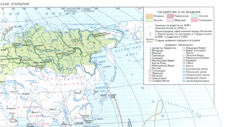
At the end of the 15th and beginning of the 16th century, the formation of the Russian state was completed, which developed along with world civilization. This was the time of the Great Geographical Discoveries (America was discovered in 1493), the beginning of the era of capitalism in European countries (the first bourgeois revolution in Europe, 1566-1609, began in the Netherlands). Great geographical discoveries - a period in human history that began in the 15th century and lasted until the 17th century, during which Europeans discovered new lands and sea routes to Africa, America, Asia and Oceania in search of new trading partners and sources of goods that were in great demand in Europe. Historians usually correlate the "Great Geographical Discoveries" with the pioneering long-distance sea voyages of Portuguese and Spanish travelers in search of alternative trade routes in "India" for gold, silver and spices. But the development of the Russian state took place in rather peculiar conditions.

The Russian people contributed to the great geographical discoveries of the 16th - first half of the 17th century. significant contribution. Russian travelers and navigators made a number of discoveries (mainly in northeast Asia) that enriched world science. The reason for the increased attention of Russians to geographical discoveries was the further development of commodity-money relations in the country and the associated process of the formation of the all-Russian market, as well as the gradual inclusion of Russia in the world market. During this period, two main directions were clearly outlined: northeastern (Siberia and the Far East) and southeastern (Central Asia, Mongolia, China), along which Russian travelers and sailors moved. The trade and diplomatic trips of the Russian people in the 16th - 17th centuries were of great educational value for contemporaries. to the countries of the East, survey of the shortest land routes for communication with the states of Central and Central Asia and with China.
In the middle of the 16th century, the Muscovy conquered the Kazan and Astrakhan Tatar khanates, thus annexing the Volga region to their possessions and opening the way to the Ural mountains. The colonization of the new eastern lands and the further advance of Russia to the east were directly organized by the wealthy merchants Stroganovs. Tsar Ivan the Terrible granted huge holdings in the Urals and tax privileges to Anikey Stroganov, who organized a large-scale resettlement of people to these lands. The Stroganovs developed agriculture, hunting, salt production, fishing and mining in the Urals, and also established trade relations with Siberian peoples. The process of developing new territories in Siberia (from the 1580s to the 1640s), the Volga region, the Wild Field (on the Dnieper, Don, Middle and Lower Volga, Yaike rivers) took place.
Great geographical discoveries contributed to the transition from the Middle Ages to modern times.
The conquest of Siberia by Ermak Timofeevich
Of great importance in the history of geographical discoveries of this era was the survey of vast areas of the north and northeast of Asia from the Ural ridge to the coast of the Arctic and Pacific oceans, i.e. all over Siberia.
The process of conquering Siberia included the gradual advancement of Russian Cossacks and servicemen to the East up to their exit to the Pacific Ocean and consolidation in Kamchatka. The routes of movement of the Cossacks were predominantly waterways. Getting acquainted with the river systems, they walked the dry path exclusively at the watershed, where, having crossed the ridge and arranging new boats, they descended along the tributaries of new rivers. Upon arrival in the area occupied by some tribe of natives, the Cossacks entered into peace negotiations with them with a proposal to obey the White Tsar and pay yasak, but these negotiations did not always lead to successful results, and then the matter was decided by arms.
The annexation of Siberia was started in 1581 by the campaign of the detachment of the Cossack ataman Ermak Timofeevich. His detachment, consisting of 840 people, carried away by the rumor about the untold riches of the Siberian Khanate, was equipped with funds from the large landowners and salt producers of the Urals Stroganovs.
On September 1, 1581, the detachment sank onto plows and climbed the tributaries of the Kama to the Tagil Pass in the Ural Mountains. With an ax in their hands, the Cossacks made their own way, cleared debris, fell trees, chopped a clearing. They did not have the time and energy to level the rocky path, as a result of which they could not drag ships along the ground using rollers. According to the participants in the campaign, they dragged the ships up the mountain “on themselves,” in other words, on their hands. At the pass, the Cossacks built an earthen fortification - Kokuy-town, where they hibernated until spring.
The first skirmish of the Cossacks with the Siberian Tatars took place in the area of the modern city of Turinsk (Sverdlovsk region), where the warriors of Prince Yepanchi fired at Yermak's plows from bows. Here Ermak, with the help of squeaks and cannons, dispersed the cavalry of Murza Yepanchi. Then the Cossacks occupied the town of Chingi-turu (Tyumen region) without a fight. A lot of treasures were taken from the site of modern Tyumen: silver, gold and precious Siberian furs.
November 8, 1582 A.D. Ataman Ermak Timofeevich occupied Kashlyk, the then capital of the Siberian Khanate. Four days later, the Khanty from the r. Demianka (Uvat district), brought furs and food supplies, mainly fish, as a gift to the conquerors. Ermak greeted them with "affection and greetings" and let them go "with honor." Local Tatars, who had previously fled from the Russians, reached for the Khanty with gifts. Ermak accepted them just as kindly, allowed them to return to their villages and promised to protect them from enemies, primarily from Kuchum. Then the Khanty from the left-bank regions began to come with furs and food - from the Konda and Tavda rivers. Ermak imposed an annual obligatory tax on everyone who came to him - yasak.
At the end of 1582, Yermak sent an embassy to Moscow, led by his faithful assistant Ivan Koltso, to inform the tsar of the defeat of Kuchum. Tsar Ivan IV gave the Cossack delegation of Ivan Ring a gracious welcome, generously gifted the envoys - among the gifts there was chain mail of excellent work - and sent them back to Ermak.
In the winter of 1584-1585, the temperature in the vicinity of Kashlyk dropped to -47 °, icy northern winds began to blow. Deep snows made hunting in the taiga forests impossible. In the hungry winter time, wolves gathered in large flocks and appeared near human dwellings. Sagittarius did not survive the Siberian winter. They perished without exception without taking part in the war with Kuchum. Semyon Bolkhovskoy himself, who was appointed the first governor of Siberia, also died. After a hungry winter, the number of Yermak's detachment dramatically decreased. To save the surviving people, Ermak tried to avoid clashes with the Tatars.
On the night of August 6, 1585, Yermak died along with a small detachment at the mouth of the Wagai. Only one Cossack managed to escape, who brought the sad news to Kashlyk. The Cossacks and servicemen who remained in Kashlyk gathered a circle on which they decided not to winter in Siberia.
At the end of September 1585, 100 servicemen arrived in Kashlyk under the command of Ivan Mansurov, sent to help Yermak. They did not find anyone in Kashlyk. When trying to return from Siberia by way of their predecessors - down the Ob and further "through the Kamen" - the servicemen were forced, due to the "freezing of the ice", to place "a hail over the Ob opposite the mouth of the river" of the Irtysh, and in it there was a "wintering season". Having withstood a siege here "from many Ostyaks", Ivan Mansurov's people returned from Siberia in the summer of 1586.
The third detachment, which arrived in the spring of 1586 and consisted of 300 people under the leadership of the governor Vasily Sukin and Ivan Myasny, brought with them the “written head of Danilo Chulkov” “for the establishment of business” on the spot. The expedition, judging by its results, was carefully prepared and equipped. To establish the power of the Russian government in Siberia, she had to found the first Siberian government prison and the Russian city of Tyumen.
Random nature photos
Study of China. The first voyages of Russian sailors
The distant China attracted close attention of the Russian people. Back in 1525, while in Rome, the Russian ambassador Dmitry Gerasimov told the writer Pavel Ioviy that it was possible to travel from Europe to China by water through the northern seas. Thus, Gerasimov expressed a bold idea of mastering the Northern Route from Europe to Asia. Thanks to Iovius, who published a special book about Muscovy and the Gerasimov embassy, this idea became widely known in Western Europe and was received with keen interest. It is possible that the organization of the Willoughby and Barents expeditions was prompted by reports from the Russian ambassador. In any case, the search for the Northern Sea Route to the east was already in the middle of the 16th century. led to the establishment of direct maritime links between Western Europe and Russia.
Back in the middle of the XVI century. The voyages of Russian polar sailors from the European part of the country to the Gulf of Ob and to the mouth of the Yenisei are mentioned. They moved along the coast of the Arctic Ocean on small keel sailing vessels - koches, well adapted to sailing in the ice of the Arctic due to the egg-shaped hull, which reduced the danger of ice compression.
The 16th century is known for the reign of the Russian Tsar Ivan IV the Terrible. I would like to pay special attention to the oprichnina policy of the then ruler. State terror agitated the population, "glory and pestilence" reigned in the country, peasants fled from the ruined landowners and "wandered between the courtyards." It can be assumed that it was the fugitive peasants who became the "discoverers" of new lands, and only later more high-status individuals made "discoveries" at the state level.
Most likely, in the 16th century, Russian travel, which resulted in geographical discoveries, experienced a period of "inception". The first attempts were made to travel to other countries in new lands. One of the most important and promising was the conquest of Siberia by Yermak. But our ancestors did not stop there, they also tried their hand at traveling on water. So far, great discoveries have not been made in this industry, but already in the 17th century, certain successes were made.
There were a sufficient number of factors stimulating the people to further develop new lands, the main of which was the lack of access to the sea.
The main travel destinations of the 17th century
"Mangazeya course". Penda's hike
Already in the first two decades of the 17th century, there was a fairly regular water communication of Western Siberian cities with Mangazeya along the Ob, the Ob Bay and the Arctic Ocean (the so-called "Mangazeya course"). The same message was maintained between Arkhangelsk and Mangazeya. According to the testimony of contemporaries, "from Arkhangelsk to Mangazeya, for all the years, many commercial and industrial people with all sorts of German (ie foreign, Western European) goods and bread go kotchas". It was extremely important to establish the fact that the Yenisei flows into the very "Frozen Sea" along which they sail from Western Europe to Arkhangelsk. This discovery belongs to the Russian merchant Kondraty Kurochkin, who was the first to survey the fairway of the lower Yenisei up to the mouth.
A serious blow to the "Mangazeya course" was inflicted by the government bans of 1619-1620. to use the sea route to Mangazeya, with the aim of preventing the penetration of foreigners there.
Moving eastward into the taiga and tundra of Eastern Siberia, the Russians discovered one of the largest rivers in Asia, the Lena. Penda's campaign (up to 1630) stands out among the northern expeditions to the Lena. Starting his journey with 40 companions from Turukhansk, he walked all over the Lower Tunguska, crossed the portage and reached the Lena. Descending along the Lena to the central regions of Yakutia, Penda then swam along the same river in the opposite direction almost to the headwaters. From here, passing the Buryat steppes, he got to the Angara (Upper Tunguska), the first of the Russians swam down the entire Angara, overcoming its famous rapids, after which he went to the Yenisei, and along the Yenisei returned to the starting point - Turu-khansk. Penda and his companions made an unprecedented circular journey of several thousand kilometers through difficult terrain.
Petlin's mission
The first reliable evidence of a trip to China is information about the embassy of the Cossack Ivan Petlin in 1618-1619. (Mission Petlin). The journey was made on the initiative of the Tobolsk governor, Prince I. S. Kurakin. The mission of 12 people was headed by the Tomsk Cossacks teacher Ivan Petlin (who spoke several languages) and A. Madov. The mission was entrusted with describing new routes to China, collecting information about it and neighboring countries, and also establishing the sources of the Ob River. In China, Petlin had to announce where the mission had come from and to find out the possibility of establishing further relations with China.
Leaving Tomsk on May 9, 1618, together with the ambassadors of the Mongolian "Altyn Tsar", the mission climbed the Tom valley, crossed Gornaya Shoria, crossed the Abakan ridge, Western Sayan and entered Tuva. Then she crossed the upper reaches of the Kemchik (Yenisei basin), crossed several ridges and came out to the mountain lake Uureg-Nuur, slightly saline. Turning to the east and descending into the steppe, three weeks after leaving Tomsk, the mission arrived at the headquarters of the Mongol Khan near the drainless lake Usap.
From here the travelers moved to the southeast, crossed the Khan-Khuhei - the northwestern spur of the Khangai ridge - and the Khangai itself - and along its southern slopes traveled about 800 km. At the bend of the Kerulen River, they turned southeast and crossed the Gobi Desert. Before reaching Kalgan, Petlin saw the Great Wall of China for the first time.
In late August, the mission reached Beijing, where it negotiated with representatives of the Ming Dynasty government.
Due to the lack of gifts, Petlin was not received by Emperor Zhu Yijun, but received his official letter addressed to the Russian Tsar with permission for the Russians to re-send embassies and trade in China; as for diplomatic relations, it was proposed to conduct them by correspondence. The diploma remained untranslated for decades, until Spafari (a Russian diplomat and scientist; known for his scholarly works and the embassy in China) began studying it, preparing for his embassy. The widespread expression of the Chinese letter refers to this particular document, which lay in the ambassadorial order, and the content of which remained a mystery.
Returning to his homeland, Ivan Petlin presented in Moscow "a drawing and painting about the Chinese region." His mission was of great importance, and the report on the trip - "Painting to the Chinese state and Lobinsky, and other states, inhabited and nomadic, and uluses, and the great Ob, and rivers and roads" - became the most valuable, most complete description of China, containing information about the land route from Europe to China through Siberia and Mongolia. Already in the first half of the 17th century, "Painting" was translated into all European languages. The information collected as a result of Petlin's trip about the routes to China, the natural resources and economies of Mongolia and China contributed to the expansion of the geographical horizons of his contemporaries.
Russian discoveries in the Pacific Ocean. Explorers of Siberia
The conquest of Siberia was accompanied by a very rapid expansion of the geographic outlook. Not even 60 years have passed since Yermak's campaign (1581-1584), when the Russians crossed the entire continent of Asia from the Ural ridge to the eastern reaches of this part of the world: in 1639, the Russians first appeared on the shores of the Pacific Ocean.
Moskvitin's hike (1639-1642)
Ataman Dmitry Kopylov, sent from Tomsk to the Lena, founded a winter hut in 1637 at the confluence of the Map and Aldan. In 1639 he sent the Cossack Ivan Moskvitin. They crossed the ridge and reached the Sea of Okhotsk at the mouth of the river. Beehives, west of present-day Okhotsk. In the coming years, people from the Moskvitin detachment explored the coast of the Sea of Okhotsk to the east to the Tauiskaya Bay, and to the south along the river. Ouds. From the mouth of the Cossacks went further east, towards the mouth of the Amur. He returned to Yakutsk in 1642.
Dezhnev's hike (1648)
For the first time, a Yakut Cossack, a native of Ustyug, Semyon Dezhnev, passed through the Bering Strait. On June 20, 1648, he left the mouth of the Kolyma to the east. In September, the explorer rounded Bolshoi Kamenny Nose - now Cape Dezhnev - where he saw the Eskimos. He saw two islands opposite the cape. This refers to the Diomede or Gvozdev islands lying in the Bering Strait, on which the Eskimos lived then, as now. Then storms began, which carried Dezhnev's boats across the sea until, after October 1, they were thrown south of the mouth of the Anadyr; it took 10 weeks to walk from the crash site to this river. In the summer of the following year, Dezhnev built a winter hut on the middle reaches of the Anadyr - later the Anadyr prison.
"Parcels" by Remezov
Semyon Ulyanovich Remezov - cartographer, historian and ethnographer, can rightfully be considered the first explorer of the Trans-Urals. Traveling on behalf of the Tobolsk authorities to collect rent in the central part of the West Siberian Plain and some other areas of the eastern slope of the Urals, i.e. being in his words "parcels", he created a scheme for the study of these territories, carried out later in an expanded form during the work of the Academic detachments of the Great Northern Expedition. At first, the description of the places visited was for Remezov a matter of secondary importance. But since 1696, when he, as part of a military detachment, spent six months (April-September) in the waterless and impassable stone steppe beyond the river. Ishim, this activity became the main one. In the winter of 1696-1697. with two assistants, he carried out a survey of the Tobol basin. He plotted the main river from the mouth to the top, photographed its large tributaries - Tura, Tavda, Iset and a number of rivers flowing into them, including the Miass and Pyshma.
R. Irtysh from the confluence of the Ob to the mouth of the river. Tara and its three tributaries. In 1701, Remezov completed the drawing up of the "Drawing Book of Siberia". She played a huge role not only in the history of Russian, but also in world cartography.
Discovery of Kamchatka by Atlasov
Information about Kamchatka was first obtained in the middle of the 17th century, through the Koryaks. But the honor of discovery and geographical description belongs to Vladimir Atlasov.
In 1696, Luka Morozko was sent from Anadyrsk to the Koryaks on the Opuka River (Opuka flows into the Berengovo Sea). It penetrated much further south, namely to the river. Tigil. At the beginning of 1697 Atlasov set out from Anadyrsk. From the mouth of the Penzhina, they walked for two weeks on reindeer along the western coast of Kamchatka, and then turned east, to the shores of the Pacific Ocean, to the Koryaks - Olyutors who sit along the river. Olutore. In February 1697 on Olyutor Atlasov divided his detachment into two parts: the first went along the eastern coast of Kamchatka to the south, and the second part went with him to the western bank, on the river. Palan (flows into the Sea of Okhotsk), from here to the mouth of the river. Tigil, and finally, on the river. Kamchatka, where he arrived on July 18, 1697. Here they first met the Kamchadals. From here Atlasov walked south along the western coast of Kamchatka and reached the river. Golygina, where the Kurils lived. From the mouth of this river, he saw the islands, meaning the northernmost of the Kuril Islands. From Golygina Atlasov across the river. Ichu returned to Anadyrsk, where he arrived on July 2, 1699. This is how Kamchatka was discovered. Atlasov made a geographical description of it.
E.P. Khabarov and I.V. Poryakova on Amur
Erofei Pavlovich Khabarov continued the work started by another explorer, V.D. Poyarkov. Khabarov was from near Veliky Ustyug (according to other sources from Solvychegodsk). Life at home was hard, and debts forced Khabarov to go to the distant regions of Siberia. In 1632 he arrived at Lena. For several years he was engaged in the fur trade, and in 1641 he settled on an empty land at the mouth of the river. Kirenga is the right tributary of the Lena. Here he started arable land, built a mill and a salt brewhouse. But the Yakut voivode P. Golovin took away from Khabarov both arable land and a salt brewhouse and handed them over to the treasury, and he himself, Khabarov, was imprisoned. Only in 1645 Khabarov was released from prison "naked as a falcon." In 1649 he arrived at the Ilimsky prison, where the Yakut voivode stayed for the winter. Here Khabarov learned about the expedition of V.D. Poyarkov and asked permission to organize his expedition to Dauria, for which he received consent.
In 1649, Khabarov with a detachment climbed up the Lena and Olekma to the mouth of the river. Tungir. In the spring of 1650 they reached the river. Urks, a tributary of the Amur, and fell into the possession of the Daurian prince Lavkaya. The cities of the Dauras turned out to be abandoned people. Each city had hundreds of houses, and each house had 50 or more people. The houses were bright, with wide windows covered with oiled paper. Rich grain reserves were stored in the pits. Prince Lavkai himself was found at the walls of the third city, the same empty. It turned out that the Daurs, having heard about the detachment, got scared and fled. From the stories of the Daurs, the Cossacks learned that on the other side of the Amur lies a country richer than Dauria and that the Daurs pay tribute to the Manchu prince Bogda. And that prince had large ships with goods sailing along the rivers, and he has an army with cannons and squeaks.
Khabarov understood that the forces of his detachment were small and he could not take possession of the region where the population was hostile. Leaving about 50 Cossacks in the town of Lavkaya, in May 1650 Khabarov returned to Yakutsk for help. A report on the campaign and a drawing of Dauria were sent to Moscow. And Khabarov began to collect a new detachment for a campaign in Dauria. In the fall of 1650, he returned to the Amur and found the abandoned Cossacks near the fortified town of Albazin. The prince of this city refused to pay yasak, and the Cossacks tried to take the city by storm. With the help of Khabarov's detachment that came to the rescue, the Daurs were defeated. The Cossacks took many prisoners and a lot of booty.