Geographical location and nature of the Urals presentation. Presentation on geography on the topic "Ural" (grade 9)
8th grade was completed by Kolegova L.V. geography teacher s. Bolshoi Bukor, Chaikovsky district, Perm region, Urals
At the junction of two parts of the world, Europe and Asia, the largest lithospheric plates, the largest river basins.
A continuation of the Ural Mountains in the north are the islands of Novaya Zemlya and Vaygach, and in the south are the Mugodzharsky Mountains
1 . This is a single mountain system created during the Hercynian folded era. The main features are:
2. The barrier position in relation to the westerly winds enhances cyclonic activity in the west and creates sharp differences between the western and eastern slopes.
3. Shift of the boundaries of landscape belts in the mountains to the south relative to their boundaries on the plains.
Stages of the origin of the Ural Mountains. Stage 1. Archean and Proterozoic era. Stage 2. Palaeozoic. (Hercynian folding) Stage 3. Mesozoic era. Stage 4. Cenozoic era. + + + +
Latitudinal profile of the Urals. Russian Plain Main (watershed) ridge 1200 1800 1600 Western foothills Eastern foothills West Siberian Plain The Ural Mountains are asymmetrical: the western slope is gentle, the eastern slope is quite steep.
Minerals The placement of minerals is related to the geological structure. In the western foothills, in a tectonic trough dominated by sedimentary rocks, there are minerals of sedimentary origin: potassium salts, table salts, limestones and marbles, refractory clays, sands, coals and sulfur pyrites. There are oil and gas reserves in the Urals. salt mining potash salt coal
In the Northern Urals there are bauxites. The main wealth of the Urals is the ores of ferrous and non-ferrous (copper, nickel) metals. igneous rocks In the eastern foothills and Trans-Urals, composed of igneous rocks, ore deposits (iron, copper and manganese ores) copper have been discovered
The Urals are also rich in precious metals (gold, platinum, silver), precious, semi-precious, and also ornamental stones. platinum gold silver
Differences in the climate of the northern and southern regions Climate change with altitude Differences in the climate of the western and eastern macroslopes. climate
Western slope. The weather is softened by warm Atlantic air. More precipitation falls. In the northern part of the Cis-Urals spruce and broad-leaved-spruce forests grow, in the south there are forest-steppe and steppe. Climate: moderate continental
Eastern slope Continental climate Zone of influence of cold Siberian air Larch and small-leaved forests dominate in the Trans-Urals
In the Urals there are the Pechora-Ilychsky biosphere and 10 more reserves (Vishersky, Denezhkin Kamen, Basegi, Visimsky, Ilmensky, etc.) and 5 national parks. Protected places Attractions
No. 6. Pechoro-Ilychsky reserve. Founded in 1930 Here you can find oddly shaped remains. No. 7. Mount Denezhkin Stone No. 10. Reserve "Denezhkin Stone" No. 8. Mount Konzhakovsky Stone No. 9. Vishera Reserve. Northern Urals
Here is the large Kaninskaya Cave (63m) - it served as a place of sacrifice for local residents from ancient times until the beginning of the 19th century. The world's northernmost Paleolithic site of a man who lived here 20,000-25,000 years ago was found in the Bear Cave. A large number of bones of extinct animals, such as the cave bear and the tiger lion, were also discovered. Northern Urals
The only mineralogical reserve in the world. They call it the richest pantry of the Ural Mountains. Ancient mines (400) have been preserved here, in which you can see “outlandish pebbles” from the tales of P.P. Bazhov Southern Urals Ilmensky Reserve The pride of the reserve is ilmenite, a black mineral with a semi-metallic sheen; in 2005 it became known that an ilmenite deposit exists in Moon. In total, 270 minerals were discovered in Ilmeny, of which 17 were discovered for the first time. There are rare and rare ones here, not found anywhere else in the world
Southern Urals Kapova Cave Cave with wall images of the Paleolithic era on the Belaya River.
Test: Complete the sentence. The Urals stretches for more than ... kilometers from the coast ... of the sea to the steppes.... The chains of the Ural Mountains form the border between the region of temperate continental and... climate, between the Volga basin and..., between the Russian Plain and..., between the ancient platform and.... 2 . In terms of height, the Urals are classified as mountains: a) low b) medium c) high; 3. According to their structure, the Ural Mountains are classified as: a) folded b) folded-block c) block. 4. Choose the correct statements. a) The share of glaciers in feeding the Ural rivers is very significant. b) The main wealth of the Urals is forest resources. c) The Urals are a natural boundary between the Russian and West Siberian plains. d) More precipitation falls on the western slopes of the Ural Mountains than on the eastern ones
5. Indicate the part of the Urals that has the greatest absolute height: a) Polar Urals; b) Subpolar Urals; c) Northern Urals; d) Middle Urals e) Southern Urals 6. Indicate the absolute height of the highest point of the Ural Mountains - Mount Narodnaya: a) 5642 m; b)8848 m; c) 1895 m; d) 2922 m. 7. Select the characteristic features of the Subpolar Urals: a) parallel arrangement of ridges; b) the highest altitudes in the Urals; c) strong earthquakes; d) distinct traces of ancient glaciations.
7. Identify the numbers that indicate in the figure: a) Mount Yamantau; b) the Pechora River; c) the Ural River d) Pechora-Ilychsky Nature Reserve; e) Pai-Khoi ridge; f) Southern Urals; g) Northern Urals; h) Subpolar Urals. i) Mount Narodnaya; j) Chusovaya River; k) Ilmensky Nature Reserve; m) Mount Konzhakovsky Stone; Answers: a2, b4, c10, d6, d15, e13, h7, i1, k8, l11, m3.
Slide 2
Story
The ancient inhabitants of the Urals were the Bashkirs, Udmurts, Komi-Permyaks, Khanty (Ostyaks), Mansi (formerly Voguls), and local Tatars. Their main occupations were farming, hunting, fishing, cattle breeding and beekeeping. Communication between indigenous peoples and Russians goes back centuries. Back in the 11th century. Novgorodians paved a waterway to the Urals and Siberia. They founded their first settlements in the Urals in the upper reaches of the Kama; they were attracted here by fur riches. The 18th century is the century of development of the mining industry of the Urals. At this time, geographer V.N. Tatishchev was studying the natural resources of the Ural Mountains and describing them. He substantiated the need to build a large industrial center in the Urals and chose a location for it. This is how Yekaterinburg was founded. Geological exploration of the Urals was actively carried out in the 19th century. A. P. Karpinsky, I. V. Mushketov, E. S. Fedorov. The mining industry of the Urals was studied and helped to improve by the famous scientist D.I. Mendeleev.
Slide 3
I. V. Mushketov
E. S. Fedorov A. P. Karpinsky
Slide 4
Geographical position
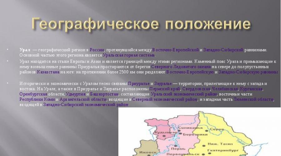
The Urals is a geographical region in Russia and Kazakhstan, stretching between the East European and West Siberian plains. The main part of this region is the Ural mountain system. The Urals are located at the junction of Europe and Asia and are the border between these regions. The stone belt of the Urals and the adjacent elevated plains of the Urals extend from the shores of the Arctic Ocean in the north to the semi-desert regions of Kazakhstan in the south: for more than 2,500 km they separate the East European and West Siberian plains.
Slide 5
The Southern Urals are the widest southern part of the Ural Mountains. The mountains of the Southern Urals represent the remnants of an old mountain system, which, along with the entire territory of the modern Chelyabinsk region, covered a significant adjacent part of modern Bashkortostan and the territories to the east of the region. Even earlier, apparently, there was an ancient ocean in this place. The highest points are mountains Yamantau (1638 m) and Iremel (1582 m).
Slide 6
The Middle Urals are the lowest part of the Urals, lying between 56° and 59° N. w. , approximately 60°E. d. Average heights are 250-500 m, in the north up to 994 m (Mount Middle Baseg). Mount Jurma is considered the southern border. There are many minerals in the Middle Urals, especially metals: (iron, copper, gold, etc.) and stones (malachite, etc.). Many of the mines have been in use for centuries and are almost exhausted.
Slide 7
The Northern Urals are part of the Ural Mountains, stretching from the Kosvinsky Kamen and the neighboring Konzhakovsky Kamen (59° N) in the south to the northern slopes of the Telposis massif, or more precisely, to the bank of the Shchuger River, which goes around it from the north. The Northern Urals are one of the most remote and inaccessible regions of the Urals. Bear's Corner is the name of one of its peaks. North of Ivdel, Vizhay and Ushma there are almost no settlements and therefore no roads. Impenetrable forests and swamps approach the mountains from the east and west. The climate here is already quite harsh. There are many snowfields in the mountains that do not have time to melt during the summer. There are also patches of permafrost, up to the latitude of Konzhakovsky Kamen. And although there are no glaciers in these areas, two small glaciers were found in the karas of Telposiz - the highest massif of the Northern Urals.
Slide 8
The Subpolar Urals is a mountain system in Russia, stretching from the sources of the Lyapin (Khulga) River in the north (65º 40' N) to Mount Telposis ("Nest of the Winds", height about 1617 m) in the south (64º N) . The area of the mountainous region alone is about 32,000 km². The main rivers of the western slope: Kosyu and Kozhim This is the highest part of the Urals, a mountain node within which the mountain system changes direction from southwestern to submeridional. It is represented by large isolated massifs. Several peaks have heights of more than 1600 m: Mount Karpinsky (1662 m), Neroika (1646 m), Kolokolnya (1649 m). Here is the highest point of the Urals - Mount Narodnaya.
Slide 9
The Polar Urals is a mountainous region in northern Eurasia, on the territory of Russia, the northernmost part of the Ural Mountains. The northern border of the region is considered to be Mount Constantine Stone, and the region is separated from the Subpolar Urals by the Khulga River. Area - about 25,000 km². The Polar Urals are located on the border of Europe and Asia, on the territory belonging to the Komi Republic and the Yamalo-Nenets Autonomous Okrug. The conventional border of the parts of the world coincides with the border of the regions and runs mainly along the main watershed of the ridge, separating the Pechora (in the west) and Ob (in the east) basins.
Slide 10
Relief
The relief of the Urals clearly distinguishes two strips of foothills (western and eastern) and a system of mountain ranges located between them, stretched parallel to each other in the submeridional direction, corresponding to the strike of the tectonic zones. There may be two or three such ridges, but in some places their number increases to six to eight. The ridges are separated from each other by extensive depressions along which rivers flow. The Urals consists of meridional ridges and ridges, separated by longitudinal and transverse valleys of the upper rivers Shchugor, Ilych, Podcherya, Pechora, Vishera and their tributaries. The total width of the mountain strip is 50-60 km, and with foothill ridges - up to 100 km. The Ural Mountains are low. Only some of their peaks exceed 1500 m. The highest point of the Urals is Mount Narodnaya (1895 m). A characteristic feature of the relief of the Urals is the presence of ancient leveling surfaces raised to different heights. Therefore, flat-topped or dome-shaped ridges and massifs predominate here, regardless of their height. Many researchers studied them in different parts of the Urals. However, to date there is no consensus on either the number or age of these surfaces. Different researchers in different parts of the Urals, and sometimes in the same territory (for example, the Southern Urals), identify from one to seven surfaces.
Slide 11
Schematic diagram of the structure of the main structural elements of the Urals
Slide 12
Slide 13
Climate
The climate of the Urals is typical mountainous; precipitation is distributed unevenly not only across regions, but also within each region. The climate is sharply continental, harsh, with long frosty winters and short cool summers. Precipitation in the most elevated areas of the western slope falls from 1000 to 1500 mm per year. The eastern slope is drier - from 600 to 800 mm. The West Siberian Plain is a territory with a harsh continental climate; in the meridional direction its continentality increases much less sharply than on the Russian Plain.
Slide 14
Soils
The soils of the foothills are similar to the zonal soils of the adjacent plains. In the north they are represented by tundra-gley loamy soils and tundra podburs on stony-crushed eluvium and colluvium of bedrock. These soils approach the foothills of the mountains on the western slope up to 65° N, and on the eastern slope only up to the Arctic Circle. To the south, taiga soils are widespread in a wide strip - gley-podzolic, podzolic and sod-podzolic in combination with marsh soils. In the Cis-Ural region south of Perm, they are replaced by gray forest soils with patches of podzolized, leached and typical chernozems gradually increasing to the south. In the Trans-Urals at these latitudes, leached chernozems with areas of meadow-chernozem and small patches of gray forest soils predominate. In the Sakmara River basin in the Cis-Urals, and in the Trans-Urals south of the Uy River, i.e. 180 - 200 km to the north, the dominance in the soil cover passes to southern chernozems, which are replaced in the southeast by southern solonetzic chernozems and dark chestnut solonetzic soils. Mountain soils of all types found in the Urals have some common features. They have a short profile and are saturated with clastic material. The most common and diverse here are mountain forest soils: podzolic, brown-taiga, acidic non-podzolized, gray forest and soddy-carbonate. Mountain chernozems are found in the Southern Urals. In the north and in the upper parts of the mountains, mountain tundra soils and mountain podburs are common. The soil cover of the mountains is interrupted by rocky outcrops, and in some places by rocky placers.
Slide 15
Vegetation cover
The Urals are quite monotonous. About 1,600 plant species take part in its formation. The poverty of the Urals in endemic species is explained by its middle position on the continent. In the far north, from foothill plains to mountain peaks, tundras are common. Plain tundras on the slopes give way to mountain tundras. Near the Arctic Circle, the tundra turns into a high-altitude belt. Forests are the most common type of vegetation. They stretch in a continuous strip along the mountain slopes of the Urals from the polar slope to the sublatitudinal section of the Sakmara River. The forests of the Urals are diverse in composition: coniferous, broad-leaved, small-leaved. Coniferous forests of Siberian spruce and Scots pine predominate. The dark coniferous forests, most characteristic of the Urals and the western slopes of the mountains, include Siberian fir and cedar. The most widespread are fir-spruce forests. There are practically no pure larch forests in the Urals. In the southern part of the taiga of the Cis-Urals (south of 58° N), an admixture of broad-leaved species appears in the composition of coniferous forests: linden, Norway maple, elm, elm. True coniferous-deciduous and broad-leaved forests are distributed only on the western slopes of the mountains of the Southern Urals. The linden forests of Bashkiria are widely known. Oak forests are also common here. Small-leaved birch and birch-aspen forests are much more widely represented in the Urals. They are distributed throughout the Urals, but there are especially many of them in the Southern and Middle Urals.
Slide 16
Slide 17
Slide 18
Slide 19
Slide 20
Slide 21
Natural resources
The natural resources of the Urals are very diverse and have a huge impact on its level of development. The Ural region has mineral resources, fuel, and non-metallic minerals. The Urals ranks first in the world in terms of reserves of certain types of mineral resources. Among the natural resources of the Urals, the most important are its mineral resources. The Urals have long been the country's largest mining and metallurgical base. And the Urals ranks first in the world in the extraction of some mineral ores. Placers of gold and deposits of platinum were found in the mountains, and precious stones were found on the eastern slope. The skill of searching for ore, smelting metal, making weapons and artistic items from it, and processing gems was passed on from generation to generation. In the Urals there are numerous deposits of high-quality iron ores (mountains Magnitnaya, Vysokaya, Blagodat, Kachkanar), copper ores (Mednogorsk, Karabash, Sibay, Gai), rare non-ferrous metals, gold, silver, platinum, the best bauxite, rock and potassium salts in the country (Solikamsk, Berezniki, Berezovskoye, Vazhenskoye, Ilyetskoye). In the Urals there is oil (Ishimbay), natural gas (Orenburg), coal, asbestos, precious and semi-precious stones. The hydropower potential of the Ural rivers (Pavlovskaya, Yumaguzinskaya, Shirokovskaya, Iriklinskaya and several small hydroelectric power stations) remains a far from fully developed resource.
Slide 22
Rivers and lakes
The rivers belong to the basins of the Arctic Ocean (on the western slope - Pechora with Usa, on the eastern slope - Tobol, Iset, Tura, Lozva, Northern Sosva, belonging to the Ob system) and the Caspian Sea (Kama with Chusovaya and Belaya; the Ural River).
Slide 23
View all slides
Slides and text of this presentation
Slide 1
Slide description:
Slide 2
Slide description:
Slide 3
Slide description:
Slide 4
Slide description:
Slide 5
Slide description:
Slide 6
Slide description:
Slide 7
Slide description:
Slide 8
Slide description:
Slide 9
Slide description:
Slide 10
Slide description:
Slide 11
Slide description: Slide description:
Among the natural resources of the Urals, the most important are its mineral resources. The Urals have long been the country's largest mining and metallurgical base. And the Urals ranks first in the world in the extraction of some mineral ores. Among the natural resources of the Urals, the most important are its mineral resources. The Urals have long been the country's largest mining and metallurgical base. And the Urals ranks first in the world in the extraction of some mineral ores. Back in the 16th century, deposits of rock salt and sandstone containing copper were known on the western outskirts of the Urals. In the 17th century, quite numerous iron deposits became known and ironworks appeared. Placers of gold and deposits of platinum were found in the mountains, and precious stones were found on the eastern slope. The skill of searching for ore, smelting metal, making weapons and artistic items from it, and processing gems was passed on from generation to generation. In the Urals there are numerous deposits of high-quality iron ores (mountains Magnitnaya, Vysokaya, Blagodat, Kachkanar), copper ores (Mednogorsk, Karabash, Sibay, Gai), rare non-ferrous metals, gold, silver, platinum, the best bauxite, rock and potassium salts in the country (Solikamsk, Berezniki, Berezovskoye, Vazhenskoye, Ilyetskoye). In the Urals there is oil (Ishimbay), natural gas (Orenburg), coal, asbestos, precious and semi-precious stones. The hydropower potential of the Ural rivers (Pavlovskaya, Yumaguzinskaya, Shirokovskaya, Iriklinskaya and several small hydroelectric power stations) remains a far from fully developed resource.
Slide 14
Slide description:
Slide 15
Slide description:
A presentation on the Ural topic is available for download below:
Slide 1
URAL Kozlova I.A. Teacher of geography and biology, Staraya Russa, Novgorod region. MAOU secondary school No. 8Slide 2
 Geographical location The territory of the Urals is located in the interfluve of the great rivers Volga-Kama and Ob-Irtysh. From west to east, the Urals are conventionally divided into three parts. The first part is the Western Urals, or the Cis-Urals, the Urals. Here the western foothills of the Ural Mountains gradually transform into the Russian Plain. The second part is the Ural Range, or Mountain Urals. The Ural range from north to south is divided into Polar, Subpolar, Northern, Middle and Southern. The third part is Trans-Urals. The eastern slope of the Ural ridge ends with a protrusion into the West Siberian Lowland.
Slide 3
 Relief In the relief of the Urals, two strips of foothills (western and eastern) and a system of mountain ranges located between them, stretched parallel to each other in the submeridional direction corresponding to the strike of the tectonic zones, are clearly distinguished. There may be two or three such ridges, but in some places their number increases to six to eight. The ridges are separated from each other by extensive depressions along which rivers flow. As a rule, ridges correspond to anticlinal folds composed of more ancient and durable rocks, and depressions correspond to synclinal folds.
Slide 4
 Relief The Ural Mountains are located in northwestern Russia. They lie between the East European and West Siberian plains. The length of the Ural ridge is more than 2000 kilometers, width - from 40 to 150 km. The highest point of the Urals is Mount Narodnaya (1895 m). The Ural Mountains were formed in the late Paleozoic during an era of intense mountain building (Hercynian folding). The formation of the Ural mountain system began in the late Devonian (about 350 million years ago) and ended in the Triassic (about 200 million years ago). In ancient sources, the Ural Mountains are called the Riphean or Hyperborean Mountains. Russian pioneers called it Stone; under the name Ural, these mountains were first mentioned in Russian sources at the end of the 17th century.
Slide 5
 Climate The climate of the Urals is typical mountainous; precipitation is distributed unevenly not only across regions, but also within each region. The West Siberian Plain is a territory with a harsh continental climate; in the meridional direction its continentality increases much less sharply than on the Russian Plain. The climate of the mountainous regions of Western Siberia is less continental than the climate of the West Siberian Plain. It is interesting that within the same zone on the plains of the Cis-Urals and Trans-Urals, the natural conditions are noticeably different. This is explained by the fact that the Ural Mountains serve as a kind of climatic barrier. To the west of them there is more precipitation, the climate is more humid and mild; to the east, that is, beyond the Urals, there is less precipitation, the climate is drier, with pronounced continental features. The climate of the Urals is varied. The mountains stretch for 2000 km in the meridional direction, and the northern part of the Urals is located in the Arctic and receives much less solar radiation than the southern part of the Urals, located south of 55 degrees north latitude.
Slide 6

Slide 7
 Northern Urals This region is wider and higher than the Middle Urals (up to 1600 m). The area is located in a mountainous zone covered with forests. The climate is more severe. The area is sparsely populated. In the Northern Urals there are Pechoro-Ilychsky and Vishera nature reserves (the fourth largest in Europe). There are a lot of berries and mushrooms in the forests, and there is good fishing in the rivers. Tourist routes pass through uninhabited areas in complete autonomy.
The Ural economic region includes: Kurgan, Orenburg, Perm, Sverdlovsk, Chelyabinsk regions, as well as the republics of Bashkortostan and Udmurtia. The basis of the region is made up of medium-high ridges and ridges, only a few peaks reach an altitude of 1500 m above sea level. The highest peak is Mount Narodnaya (1895 m). Mountain ranges stretch

parallel to each other in the meridian direction, the ridges are separated by longitudinal mountain depressions along which rivers flow. Only one main chain of mountains is almost uninterrupted by river valleys; it forms a watershed between the rivers flowing to the Russian and West Siberian plains. The Urals are strongly elongated from north to south, so the country’s most important latitudinal communications pass through it
The Ural region is located between the old industrial regions of the European part of Russia, Siberia and Kazakhstan - at the junction of the European and Asian parts of the Russian Federation. This “neighborly” position can be assessed as favorable for the functioning and development of the entire economic complex.
The territory of the district, due to its internal position between the western and eastern economic zones, which have different levels of economic development and different specializations, ensures transit connections between them.
Population of the Urals
The region is home to 20.4 million people. The average population density is 25 people/km, but in the southern and especially northern regions it decreases sharply (to 1 person/km and lower). The population of the Urals has grown somewhat in recent years due to Russian immigrants from Central Asia and Kazakhstan, but in the future it will decline, since the natural growth in the area is negative (-5). The Urals are characterized by a high level of urbanization, the concentration of the majority of the population in large cities, which is largely explained by the predominance of large enterprises in the industry of the Urals.
Natural resources
The complex geological structure of the Urals determined the exceptional wealth and diversity of its resources, and the long-term processes of destruction of the Ural mountain system exposed these riches and made them more accessible for exploitation.
The natural resources of the Urals are very diverse and have a huge impact on its level of development. The Ural region has mineral resources, fuel, and non-metallic minerals. In terms of reserves of some types of mineral resources, the Urals ranks first in the world (copper ores, asbestos, potassium salts).
The fuel resources of the Urals are represented by all main types: oil, natural gas, coal, oil shale, peat. Oil deposits are concentrated mainly in Bashkortostan, the Perm and Orenburg regions and in Udmurtia, natural gas - in the Orenburg gas condensate field, which is the largest in the European part of the country.
Deposits of iron ores and non-ferrous metal ores are concentrated mainly within the Ural Mountains. More than 2 thousand deposits and ore occurrences of iron ore are known in the Urals.
The forest resources of the region are significant. The Urals are part of the multi-forest zone of the country; in terms of forest cover, it is second only to Siberia, the Far East and the North of the European part of the country. The main part of forest resources is located in the northern part of the Ural economic region - in the Sverdlovsk and Perm regions.
Transport of the Urals
Transport plays a huge role in the functioning of the economic complex of the Urals. This is explained, on the one hand, by the region’s active participation in the territorial division of labor, and on the other, by the high level of complexity of the Ural economy, which is manifested in the fact that many sectors of the economy do not work in isolation, but in close interconnection with each other. Hence the high share of intra-district transportation
Mechanical engineering in the Urals is a large branch of its market specialization and occupies a leading place in the structure of industrial production of the Ural economic region. Currently, there are almost 150 mechanical engineering enterprises operating in the region, representing all sub-sectors of mechanical engineering. The following industries are developed here: heavy engineering (production of mining and metallurgical equipment, chemical and petrochemical equipment), energy (production of turbines, steam boilers and others), transport, agricultural engineering, tractor manufacturing. Electrical engineering, instrument making, and machine tool manufacturing are developing most rapidly.
The chemical industry, a branch of market specialization in the Urals, has a powerful raw material base, using oil, associated petroleum gases, coal, salts, sulfur pyrites, waste from ferrous and non-ferrous metallurgy, and the forestry industry. The Ural economic region is one of the leading regions in the country in the development of the chemical industry, which is represented here by all the most important industries: mineral fertilizers, synthetic resins and plastics, synthetic rubber, soda, sulfuric acid and others.
The Urals is also a major consumer of chemical industry products. Of greatest importance is the production of mineral fertilizers, among which potassium fertilizers stand out. Potash fertilizers are produced in the area where raw materials are mined
(Verkhnekamsk salt-bearing basin). The main centers are located in the Perm region (Berezniki, Solekamsk
The construction industry in the Urals relies on its own raw material base. This is one of the leading areas for the production of cement, which is produced both from natural raw materials and from ferrous metallurgy waste. The largest centers of the cement industry are Magnitogorsk, Yemanzhelinsk (Chelyabinsk region)
The Urals also plays a significant role in the production of prefabricated reinforced concrete, panel houses, bricks, gypsum, crushed stone and other products, which are supplied to many regions of the country. Construction organizations of the Ural economic region help develop oil and gas fields in Western Siberia and build many facilities in other areas
The light industry of the Ural economic region includes leather and footwear; textile enterprises have also been built, for example the Tchaikovsky Silk Fabric Factory in the Perm Region. The clothing industry is widespread. The development of light industry in the region makes it possible to solve the problem of using female labor resources in areas where heavy industry is concentrated.
|
Leave your comment, thank you! |