Classification of settlements. Locality
Read also
By type of settlement settlements are subdivided as follows: (on maps
their names are highlighted in different fonts):
Urban-type settlements (workers, resort and other settlements);
etc., not officially classified as urban-type settlements;
Settlements of rural and dacha type (stanitsa, villages, villages, kishlaks, auls), as well as
separate courtyards.
On maps, their names are distinguished with different font designs (Fig. 7.5).
Rice. 7.5. Displaying the type of settlement on topographic maps:
Dreams- town; New
- settlement; Elbow
- village
rural type
By the number of inhabitants settlements are subdivided into the following gradations:
Cities with the number of inhabitants:
1,000,000 and more
from 500,000 to 1,000,000
from 100,000 to 500,000
from 50,000 to 100,000
from 10,000 to 50,000
from 2,000 to 10,000
less than 2,000
Urban-type settlements with the number of inhabitants:
2,000 and more
less than 2000
Settlements at industrial enterprises, railway stations, marinas
etc., not officially classified as urban-type settlements, with the number of inhabitants:
1,000 and more
from 100 to 1,000
less than 100
Settlements of rural and suburban type with the number of inhabitants:
1,000 and more
from 500 to 1,000
from 100 to 500
less than 100
separate courtyards
The number of inhabitants in settlements is established according to the main cartographic
materials using the latest administrative and territorial reference books
and lists. The data of the census of settlements are necessarily involved.
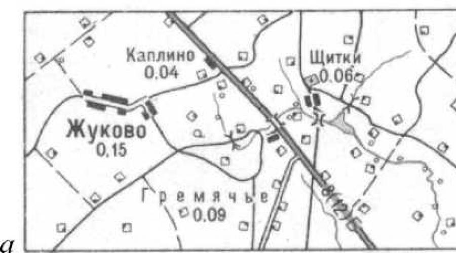
The number of inhabitants is displayed on maps in font height. On old maps under the name
the number of households is indicated by the number of settlements of the rural type, and the number of new
inhabitants in thousands with rounding (fig. 7.6):
with the number of inhabitants less than 1,000 - up to 0.01 thousand
from 1,000 to 100,000 - up to 0.1
more than 100,000 - up to thousands.
For example, if the number of inhabitants is 1 212 345, 17 145, 40, signatures are given accordingly
1212; 17,1; 0,04.

Rice. 7.6. Indication of the number of inhabitants in rural settlements:
a
- on new topographic maps in thousandths;
b
- on old maps indicating the number of yards
Political and administrative significance settlements displayed on maps
allocation of capitals of states, administrative centers and settlements in which
local authorities are located.
In addition, on these maps, underscore the name of the settlement, one
nominal names with the names of railway stations, wharves (Fig. 7.7).

Rice. 7.7. Locality Karelino,
eponymous
with the name of the train station
The nature of the layout. When depicting settlements on topographic
maps must display their layout. Cities can have regular, irregular
ny and mixed layouts.
Typical for modern cities is regular
pla
ning: rectangular, radial and combined.
Varieties of these layouts for
cauldrons are shown in Fig. 7.8.
Re2
ular layout
- quarters have the form of regular geometric shapes
and relatively straight streets.
Nere2
ular layout
- quarters can have any shape and size, on
The presence of narrow and crooked streets.
Mixed layout- part of the city has a regular layout, and the other part -
irregular.
Straight2 floor layout - all streets in the city are mutually perpendicular.
Radial layout- all streets are directed towards the city center.
Combined layout- part of the city has a radial structure, while the other
part - rectangular.


Rice. 7.8. Varieties of city layouts:
a- regular (rectangular); b- radial; v- combined
naya; 2 - irregular; d- mixed
The structure of rural settlements is:
Quarterly- represents the correct quarters, mutually separated
perpendicular streets. The built-up part of the quarters runs along the streets.
Private- represents buildings stretched out in one row with adjoining
on the one hand, household land.
Precinct- is a group of courtyards placed in disarray throughout
the area occupied by the settlement.
The nature of the location of rural-type settlements on the terrain depends on the geo
graphic landscape. They can be placed along river valleys, along ravines, along the banks
lakes and seas, at crossroads, etc. (Figure 7.9).

a -- quarterly; b- private; v- local placement;
2 - settlement in a mountain valley and near a lake

Rice. 7.9. Types of development in rural settlements:
d
- settlement along the ravine and watershed
Unsystematic building rural settlements are shown with conventional signs
individual buildings. With a large number of buildings, their selection is made, while
first of all, industrial enterprises, public buildings (school
ly, hospitals) and the largest buildings. By generalizing such a populated
point, it is necessary to preserve all extreme buildings, regardless of their size, so that you
divide the area occupied by this settlement (Fig. 7.10).

Rice. 7.10. An example of an image of a rural-type settlement with unsystematic buildings:
a b
v
Dispersed development villages of rural type are shown by conventional signs
kami of separate yards. The selection of yards is carried out in the same way as in a haphazard development.
The outer courtyards are also saved to highlight the total area occupied by the data.
settlement (Fig. 7.11).

a- on a map with a scale of 1: 25,000; b- on a map with a scale of 1: 50,000

Rice. 7.11. An example of an image of a rural-type settlement with dispersed buildings:
v
- on a map with a scale of 1: 100,000
The dispersed type of settlement is characterized by the fact that individual residential buildings
ki are located at a considerable distance from each other (more than 50 m). This type is characteristic
for Abkhazia, Central Asia.
As a rule, all settlements should be shown on topographic maps.
you. When creating maps of scales 1: 50,000 and 1: 100,000 for densely populated areas with pain
With the number of individual yards, some of the yards may not be shown. On the cards, created
located in uninhabited and sparsely populated areas, all buildings are shown, including those not
residential.
On maps with scales 1: 25,000 and 1: 50,000, fire resistant
buildings (stone
nye, brick, reinforced concrete) with orange fill, non-fire resistant
(wooden,
adobe, etc.) - filled with yellow. On maps of scale 1: 100,000 the nature of the fire
the resistance of buildings is not shown (Fig. 7.12).

Rice. 7.12. An example of an image of a rural-type settlement:
a- on a map with a scale of 1: 25,000; b
- on a map with a scale of 1: 50,000;
v
- on a map with a scale of 1: 100,000
In large cities with more than 50,000 inhabitants, oran is distinguished by the background color
chew-colored neighborhoods with dense buildings. Densely built up neighborhoods include
quarters or their parts, in which the distance between buildings, as a rule, is no more than 50 m.
In other cities with less than 50,000 inhabitants, quarters are shown with black fill
colors (fig. 7.13).

Rice. 7.13. An example of images of cities on maps at a scale of 1: 100,000:
a- a large city with more than 50,000 inhabitants; b
- small town
with a population of less than 50,000 people
The compilation of settlements is carried out in a certain sequence
(fig. 7.14):
1. First, objects are applied that are economically important or of importance
landmarks (industrial enterprises, tower-type structures, churches, memorials
nicknames).
2. An image of the outer contour, trunk and main streets is given.
3. Image of secondary streets and driveways.
4. Intra-block buildings - buildings and structures in blocks are shown.
5. Filling the land contours with conventional symbols.

Rice. 7.14. The procedure for compiling a settlement
When compiling settlements of all three scales, it is necessary to accurately preserve
definition of the outlines and position of streets, lanes, driveways, squares and quarters.
The concept of "street" includes the carriageway and sidewalks, green spaces between
them and improvement elements (lanterns, direction signs, fences, etc.).
On a map with a scale of 1: 25,000, all streets, thoroughfares and dead ends are shown. On the map ma
headquarters 1:50 000 some minor streets are not shown if their display interferes
correct display of buildings. On a map with a scale of 1: 100,000, the selection of streets and dead ends
produced depending on the size of the quarters of settlements.
Minor streets and dead ends are eliminated by combining small neighborhoods
into larger ones. At the same time, it is necessary to preserve the layout, shape and size of the quarters.
On a map with a scale of 1: 25,000 when depicting city quarters and urban settlements
type, all buildings and structures in them are shown, if the distances between them are not
less than 0.3 mm. If the distance is less than the specified value, then the structure follows until
call with selection. Outstanding buildings are applied first, then buildings,
large in size, as well as located at crossroads and on the outskirts of
settlements. Examples of generalization of the image of building blocks in cities
and villages of the dacha and rural type are shown in Fig. 7.15, 7.16.

Rice. 7.15. Generalization of the image of buildings in small towns and urban settlements
type in scale:
a - 1:10 000; b - 1:25 000; v- 1:50 000; g - 1: 100,000

Rice. 7.16. Generalization of the image of buildings in dacha and rural settlements
in scale:
a - 1:10 000; b - 1:25 000; v- 1:50 000; g - 1: 100,000
These maps also highlight parks, squares, fruit, berry and citrus orchards,
vineyards, sports grounds, as well as wastelands in the quarters of settlements.
Inscriptions of the names of settlements. All inflicted settlements must
their official name should be indicated. On a map with a scale of 1: 100,000, you can leave without
signatures of names of settlements with a population of less than 50 people, if their signatures
on this site it is impossible to place due to the large overload of the card.
1. What are the requirements for the image of settlements on a large
large-scale topographic maps?
2. How settlements are classified when they are depicted on a large scale
headquarters topographic maps?
3. How is the type of settlement transmitted on large-scale topographic
cards?
4. How are cities, urban-type settlements and rural-type settlements subdivided according to
the number of inhabitants?
5. How is the number of inhabitants represented on maps at a scale of 1: 25,000, 1: 50,000, 1: 100,000?
6. What is the difference between showing the number of inhabitants in rural-type settlements on old maps
and new ones?
7. What names of settlements are underlined in the name?
8. What layouts can cities have?
9. What is the difference between regular city planning and irregular planning?
10. What is the difference between mixed and combined city planning?
11. What types of buildings are there in rural-type settlements?
12. Give a description of the haphazard development of a rural-type settlement.
13. Give a description of the dispersed development of a rural settlement
14. How are settlements selected on maps of these scales?
15. In what sequence is the settlement compiled on the maps of these mas
headquarters?
16. How are streets, thoroughfares and dead ends selected?
17. How are outstanding buildings displayed?
18. To what scale, inclusive, is the fire resistance of the neighborhoods shown? How is she
transmitted on cards?
19. What does the orange color of quarters mean on topographic scale maps?
20. How is the selection of buildings done within the quarters of settlements?
21. How are densely built-up parts of the blocks shown?
22. How is the selection of buildings done in case of haphazard construction?
23. How is the selection of detached yards done when depicting settlements
tov with dispersed buildings?
24. What settlements on maps with a scale of 1: 100,000 can be left without
write?
7.4. Image of communication lines and their generalization
On topographic maps, roads are subdivided by mode of travel, mate
rial of coverage, conditions of traffic and throughput.
Topographic maps show:
Railways;
Monorails and cableways, funiculars and bremsbergs, tram lines
and ground sections of metro lines;
Highways, roads with improved surfaces and roads from to
covering;
Unpaved roads or improved unpaved roads, unpaved roads, field roads
and forest roads;
Caravan routes, pack and hiking trails, winter roads;
Railway structures (stations and metro stations, crossings, boards
forms, stopping points, railway stations, depots, checkpoints, semaphores and light
tophores, etc.);
Bridges, tunnels, flyovers, viaducts, embankments and cuttings;
Pipes, pedestrian bridges, paved road ramps, fascia road sections,
gati, rowing;
Mountain passes, fences and casing along the roads.
The following requirements are imposed on maps of all three scales:
1. Correctly convey the density of the road network.
2. Accurately convey the location of the roads.
3. Correctly show the class of each road and its condition.
4. Clearly show intersections of roads, road sections near bridges, crossings and in places where
difficult to detour.
5. To display in detail the road structures that characterize the equipment of the roads,
serving as landmarks.
6. The axis of the conventional road sign must exactly correspond to the axis of its image on
cartographic material.
7. The image of roads should be consistent with the image of other elements from
holding the card.
Land routes according to the mode of movement, they are subdivided into rail
and trackless
... Railways include railways, cableways, funiki
leers and bremsbergs, tram lines and ground sections of metro lines.
Railways shown on maps with subdivision by track width (wide
co-gauge with a track gauge of 1435 mm and more, in the Russian Federation - 1524 mm) and narrow-gauge with a gauge
track less than 1435 mm); by the number of tracks for one-, two- and multi-track; by type of traction - elek
triified and others, and according to the condition of the canvas - active, under construction, dismantled
ny (Figure 7.17).

Rice. 7.17. Depiction of railways and structures on large-scale topographic
maps:
a- single-track, double-track, three-track; b- electrified: single track, double track
nye, three-track; v- narrow gauge railways and tram lines; d - suspended up to
horns and funiculars; d - railway stations
In addition, monorail railways, tram lines are also shown.
(a general conventional sign with narrow-gauge railways), suspension roads, funi
coolers (railways on steep climbs, in the mountains with cable cars) and Bremsbergs, on
land plots of metro lines.
If a railway line passes through a settlement, then it is shown without
break, and if necessary, you can reduce the thickness of the sign.
All railway stations, sidings, platforms and stops are shown on the maps.
new items. If the stations are located outside settlements, then it necessarily gives
their name. On a map with a scale of 1: 25,000, semaphores and traffic lights are shown.
Roads when depicted on maps are subdivided into highways, motorways
ghee with improved surface and paved roads, on improved unpaved
roads, dirt (country) roads, field and forest roads, caravan routes
and pack trails, hiking trails (see subsection 5.3). With special conventional signs,
There are wooden roads and winter roads (Fig. 7.18).

Rice. 7.18. An example of road classification on large-scale topographic maps:
a- motorways; b- roads with improved coverage; v- roads with
coating; d - improved dirt roads; e - roads with wooden surfaces;
e- dirt roads and difficult-to-pass road sections; f- field and forest roads;
s- winter roads
Highways, roads with improved surfaces and roads from to
all are shown on the maps of scales, regardless of the density of the road
networks. Improved dirt roads are shown as well, as a rule, all, only with a
When using maps on a scale of 1: 100,000, small roads may be excluded.
Dirt (country) roads on maps at a scale of 1: 25,000 are applied, as a rule,
all. On maps of scales 1: 50,000 and 1: 100,000, roads are plotted with selection, if in this
the area has a dense network of roads. When drawing roads of lower classes, preference is given to:
1. Roads providing communication of settlements with railway stations
tions, marinas, airfields and high-class roads.
2. Roads that are a continuation of the main thoroughfares in settlements.
3. All roads that lead to water sources, through the passes to the state
borders or along borders.
4. Connecting settlements along the shortest distance.
5. Roads with the best driving conditions and a smoother
profile.
When compiling roads, the features of the mapped terrain must be taken into account.
ritories. For example, winter roads are only shown on low-volume maps.
inhabited and hard-to-reach areas, where there are no higher class roads and travel
possible only in winter.
On maps created for sparsely populated, mountainous and desert areas with a sparse network
roads, all caravan routes and pack paths are shown.
Hiking trails are shown when depicting hard-to-reach areas (mountains,
forests, bushes, swamps), where there are no other means of communication.
Generalization of the road contour is practically not done. Generalization is allowed when iso
wandering winding roads in the mountains, when all the convolutions cannot be conveyed, while it is necessary
dimo keep all major road curves.
In addition to the main roads, the maps are marked with fascinating
road sections, gati
and rowing
with a length of at least 2 mm.
Fascines- are bunches of brushwood, laid on longitudinal beds
and pressed by the poles; from above the fascines are covered with earth or sand.
Gati - solid flooring of logs, placed over brushwood or poles.
Rowing- low embankments of soil, stones, and sand.
Sometimes all these primitive structures along the roads have local names, for example
measures, pavement.
If the roads cross mountain ranges, then it is necessary to show the passes with the signature
with their elevation marks and the period of availability, for example: (GU-X), i.e. the pass is accessible
from April to October. The main passes should be distinguished by the larger size of the sign.
and signatures.
When depicting highways and highways, their technical character is signed
statistics: coverage width (for highways - the width of one lane and the number of
los), the width of the road with shoulders (for highways) and the material of the pavement, and also denotes
the boundary of the change of the coating material. The coating material is denoted by conventional abbreviations.
signed signatures:
A - asphalt concrete, asphalt
B - cobblestone
B m - bitumen-mineral mixture
B r - paving stones
G - gravel
K - chipped stone
C - cement concrete
Щ - crushed stone
Sh l - slag
When displaying improved dirt roads, only the width of the passage is signed
part of the road.
Images of highways and highways are given signatures of road numbers, as well as
allocate numbers of trans-main routes (European, Asian, etc.). Rooms
determined by the latest road maps and atlases of highways (Fig. 7.19).
At exits outside the frame of the sheet of the map of conventional road signs, their direction is signed
nie: the signature of the proper name of the nearest settlement is given and is indicated
distance in kilometers (fig. 7.19)
The procedure and rules for drawing up roads. Roads on scale data maps are always
are compiled in sequence from the highest class to the lowest. Railways and highways
are worked out at once on the entire sheet, and the rest are compiled in separate sections.
First, road structures are drawn up, the conventional signs of which interrupt
image of a road (for example, railway stations, tunnels, bridges). Then the composition
The road itself is laid, and only after that all other road structures are applied.
When depicting roads, it is necessary to ensure that the axis of the conventional road sign
exactly corresponded to the axis of its image on the cartographic material. Vectorization
roads are made strictly along the axis of the conventional road sign.
Violation of this rule is only allowed if the merger has occurred
roads with other objects. If, when constructing roads on a smaller scale,
if the road merges with the bank of a river, lake or sea, then the conventional sign of the road is shifted.
If there is a merger of two roads, then the conventional sign of the lower class road is displaced.

Rice. 7.19. Indication of road numbers and their directions on topographic maps
Turns and intersections of roads are worked out with special care on the map. Iso
The representation of roads must be consistent with the depiction of other content elements
maps (hydrography, settlements, etc.).
Questions and tasks for self-control
1. What types of roads are shown on large-scale topographic maps?
2. How are railways classified?
3. What are the requirements for the image of roads?
4. How is a railway line shown through a built-up area?
5. How are train stations displayed? What stations are subscribed to?
6. How are highways and dirt roads classified?
7. How is the selection of unpaved and field roads done on maps at a scale of 1: 100,000?
8. Taking into account what the configuration of the roads is transferred?
9. What are the characteristics of highways and highways?
10. How are the signatures of the numbers and characteristics of the roads given?
11. What road structures are shown on maps of these scales?
12. Which lower class roads are preferred for generalization?
13. When are winter roads shown?
14. What are fascines, gati, rowing?
15. What is the characteristic of roads crossing mountain ranges?
16. What signs at the exits of the main road map sheet?
17. In what order are the roads drawn?
18. In what case can the axis of the road be moved relative to its position by
original cartographic material?
7.5. Relief image and its generalization
on large-scale topographic maps
The relief on maps of all three scales is depicted contours, conventional signs
mi
cliffs, rocks, ravines, gullies, talus, etc. and elevation marks.
Image relay
epha is supplemented with signatures of absolute and relative heights of characteristic points locally
sti, labels of contour lines and indicators of the direction of the slopes (bergstrikami)
(see subsection 5.4, 5.4.1).
As a result of the fact that large-scale topographic maps are used to
detailed study and assessment of the terrain and various calculations and measurements on
them, then the most stringent requirements are imposed on the relief image:
1. It is necessary to visually convey the nature of the relief and the degree of its dissection.
2. Accurately display the location, size and shape of uneven terrain, character
its permeability, camouflage and protective properties, as well as the ability to orient
orientation on the ground.
3. Visually and correctly convey the morphological features of various types
relief (plain-erosional, hilly-moraine, mountainous, karst, volcanic,
relief of sands, etc.).
4. Accurately and clearly convey the main orographic lines and points (watersheds,
thalweg, ledges, peaks, saddles, etc.).
5. Correctly and clearly display the direction of slopes, their steepness, as well as sharp
surface disturbances (cliffs, ravines and gullies, bedrock outcrops, etc.).
6. Place the elevation marks in such a way that it is possible to quickly determine
division of the absolute heights of points of the terrain and the excess of some points over others.
When depicting the relief with horizontals, it is very important to choose the right height.
relief sections. The main section height is set depending on the nature
relief of the mapped territory. Within one sheet of the map, the main height is
cheniya does not change.
On topographic maps, according to the following you apply
section honeycomb (Table 7.4).
The first settlements began to appear in ancient times. What is a settlement? And what types of them exist today?
The locality is ...
A settlement is understood as a place of congestion of people who live in it permanently or temporarily. This is a special area with a complex of residential buildings and infrastructure facilities (roads, pipelines, utilities, cultural and domestic buildings, and so on).
Settlement is the primary link in the system of resettlement of the population of a certain territory. It can be a small village, urban-type settlement, or a large city.
A characteristic feature of any settlement is the constancy of the use of its territory by people for living. If we talk about an independent state formation, then one of its settlements has the status of a central one and is called the capital.
The main types of settlements
The main types of modern settlements are as follows:
- town;
- rural settlement;
- settlement.
A city is usually called a relatively large (in comparison with other settlements) settlement, the inhabitants of which are predominantly employed in industry and the service sector. Cities are usually the administrative, scientific, cultural and industrial centers of their countries or territories. These are a kind of "locomotives" of the socio-economic development of any region.

Modern science cannot unequivocally answer the question of which settlement can be considered a city. In the past historical epochs, this problem was solved much easier. So, in the days of Kievan Rus, any settlement surrounded by a rampart or fortified defensive wall was called a city (hail). Later, the status of a city in Europe was received by settlements that had the right to trade.
Today, the main criterion for determining a city is population. Moreover, for each state, this parameter may be different. For example, in Denmark, a city can be a settlement with a population of only 250 people. But in Japan, the number of inhabitants in it must be at least 50 thousand.
Today, urbanists classify all cities in the world into small (up to 50,000 inhabitants), medium (50,000-100,000), large (from 100 thousand to 1 million) and million-plus cities (over 1 million people).
An urban-type settlement (abbreviated as urban-type settlement) is a settlement that, in terms of population size and other parameters, occupies an intermediate position between a city and a village. The concept was introduced during the Soviet era. In the modern post-Soviet space, urban settlements have survived in almost all states, except for Latvia, Lithuania and Moldova.

Finally, rural settlements include villages, villages, as well as stanitsa, auls, farms, etc. There are no fundamental differences between the concepts of "village" and "village" in Russia. Although historically the village was called a settlement in which there was a church with a bell tower. At the moment, there are at least 150 thousand rural settlements on the territory of the Russian Federation.
Zoning of settlements
In urban planning and land use, it is customary to distinguish three main zones of settlements:
- Residential (residential buildings, boulevards, public utilities, as well as social infrastructure facilities are located here).
- Production (there are various industrial enterprises and related structures).
- Recreational (forest park zones, squares and gardens, summer cottages, reservoirs, etc. are concentrated here).
Conclusion
A settlement is understood as a territory in which people live permanently (or temporarily, seasonally). City, village, as well as urban-type settlement - these are the main types of settlements for Russia, as well as many other countries of the world.
Version: 1.4
Date of last edit: 16.02.2015
The instruction describes the basic rules for designing a page for a settlement. These rules should be followed both when adding new settlements to the site, and when editing existing ones.
general information
The site "Rodnaya Vyatka" publishes information about settlements Vyatka region indicating geographic coordinates, descriptions and other information.
All registered site visitors can add settlements to the site. To get started, you need to go through authorization on the site (click "Login" on the upper dark bar, and if you are not registered yet - "Register").
To add a settlement to the site, you need to in the custom site menu (upper dark bar) select the item "Add" / "Settlement".
To edit a previously added settlement, you need to click the "Edit" button at the top of the settlement page. If you do not have permission to edit the material and this button is not displayed, write your information in the comments.
When adding (editing) a page of a settlement, you will be prompted to fill in a number of fields and confirm the entry of information by clicking the "Save" button.
The published information must not violate the laws of the Russian Federation.
Filling in the fields
Name
The name of the settlement is indicated in Russian in the nominative case (answers the question "What?") In modern spelling (that is, without the letters "Ѣ", "Ѳ", "i", as well as "b" at the end of the word). The type of settlement is not indicated in the name, it is provided for this.
What if the title sounds differently in different sources?
The name should be indicated as the main one that occurs in the most recent documented source (list of settlements, information from the archive, census data, Rosreestr data and other sources), except for cases where an obvious error was made in the source, which the user can confirm (this should be written in "").
What if the settlement has several names, or its name has changed?
In brackets after the main one, you can specify minor title(if more than one - separated by a comma with a space). It is advisable to put in the “name” field only the most important names that have been in effect for a long time, documented, or were widespread among local residents (if you know for certain, be sure to write about this in the description of the settlement).
You should not put in the "name" field minor names with the same root name, or indicate more than one name with the same root!
Write about all the less significant, less common names of the settlement and outdated forms of the name that you know, including those in the pre-reform spelling, in the "" field.
What about the letter "E"?
Do not replace the letter "ё" with "e", since the correct reading of the name depends on it.
At the same time, there is no need to write "e" where the available sources indicate "e", and there is no complete certainty that this letter is read as "e" (no need to rely on guesswork).
It should also be remembered that in pre-revolutionary sources the letter "ё" was practically never used, and one should not replace "e" with "ё" in names taken from these sources and not confirmed by later information.
Stress
The stress and other features of the pronunciation of names should be indicated in "".
Example filling in the field ""
If the required type is not in the list, is outdated or rarely used, you should select the type “other”, and put its name in the field “” (indicate after the name in brackets).
Status
You should select from the list the current status of the settlement at the time of adding to the site.
- there is no data- this option should be indicated if it is not possible to clarify the current status of the settlement;
- residential settlement- in the village there is a population, houses; in some cases, the resident population may be absent, but the settlement is not deregistered;
- part of another settlement - the settlement was removed from the register by joining another settlement, while it is known for certain that this territory currently has a population; otherwise, it is better to indicate the status “does not exist now”, and in the description tell about the unification of settlements;
- ruins- the settlement is uninhabited, while in its place there are decaying uninhabited houses and outbuildings;
- does not exist now - non-residential settlement, deregistered; at the same time, in the description of the settlement, if information is available, it is necessary to indicate the approximate or exact time of the disappearance of the settlement.
Description of the settlement
This field contains all known information about the settlement. It is highly undesirable to leave this field blank.
The description of the settlement should be as encyclopedic as possible, that is, the information should be indicated with references to sources, indicating the degree of reliability (“according to information from such and such a book”, “according to such and such a site”, “according to the recollections of such and such a resident "," According to unverified sources "). The style of presentation should be neutral, from the third person (you should not write "I", "mine"). The information should be presented in a logical sequence, adhering to a specific plan. It is better to write insignificant information in the comments (in free form, you can write in the first person).
1) Basic information:
- variants of the name of the settlement: accent, outdated names, popular names, etc.;
- location in relation to the administrative center (center of the district, rural settlement), other large settlements and other geographical objects - rivers, lakes, hills, etc.;
- the size of the settlement, the geographical description of the territory, plans and schemes;
- population: number of residents, ethnic composition, income level of residents, etc .;
- government;
- objects of social infrastructure (schools, hospitals, libraries, etc.), their description;
- operating industrial and agricultural facilities, their description and role;
- religious objects (churches, chapels, mosques, etc.), cemeteries;
- other attractions.
2) History of the settlement
- date of foundation indicating the source of information;
- date of liquidation indicating the source of information;
- history of changes in the administrative affiliation of the settlement;
- the history of the settlement of the territory of the settlement, associations and enlargements;
- history of authorities, institutions (clubs, schools, hospitals, etc.) and enterprises (factories, plants, collective farms, state farms), basic facts and dates;
- history of the local religious community (primarily for villages), key dates and facts;
3) Residents of the village
In the description of the settlement, you can indicate its famous inhabitants. In this case, it is possible not to start a separate section, but to indicate them in the context of the description.
For large settlements, it is advisable to indicate only sufficiently significant persons. The main criterion of significance is recognition among local residents. For example, such persons may be:
- heads of administrations, chairmen of collective farms;
- participants in amateur performances, cultural workers;
- clergymen;
- employees of enterprises, marked with awards and titles;
- residents who provided information on the history of the settlement.
It is better to indicate less significant residents in the comments to the settlement in free form. For example: “in this village at such and such years my grandmother lived: full name, such and such a year of birth, was engaged in such and such”.
For small settlements, you can specify all available information about the inhabitants.
4) Interesting places, stories, legends, legends associated with the settlement
If there are any, they, of course, must also be indicated.
5) Sources of information
At the end of the material, it is necessary to indicate the sources of information from which the information was taken. These can be books, documents, maps, Internet sites. It is advisable to refer to these sources in the text of the description when indicating important facts.
Location
Location (geographic coordinates) is a required field when creating a settlement.
There are two ways to specify a location:
1. Mark the settlement with the mouse on the online map
In this case, you can switch between the available "layers" (map options):
- Google Sputnik, Yandex Sputnik, Bing Sputnik - different options for satellite imagery; in each option there are areas of the earth's surface that have a higher available resolution, so try switching between them;
- OSM - Open Street Map drawn independently by Internet users; the advantage of this map is that some areas of the terrain are very well developed; but for the Kirov region, unfortunately, the coverage is very uneven;
- Yandex Maps is a fairly detailed geographical map showing all existing and recently disappeared settlements;
- "Topo-map" is a topographic map of the Soviet period, one of the most important tools for indicating the location of settlements.
2. Enter the known coordinates in the "Latitude" and "Longitude" fields in degrees in decimal format.
Specify no more than 4 decimal places (after the dot). You can specify both a period and a comma as a separator for the integer and fractional parts.
If coordinates are known in degrees, minutes and seconds, they must be converted to decimal form. To do this, divide the number of minutes by 60, the number of seconds by 3600, and add the resulting non-integers to the number of whole degrees. You can also use online converters for translation, for example this one: http://camapka.ru/convertor.html.
An example of converting coordinates. Take 49 ° 45 "35" "(north latitude). Latitude in decimal form in this case will be: 49 + 45/60 + 35/3600 ≈ 49 + 0.75 + 0.0097 = 49.7597. For longitude we do a similar calculation.
As a result of the actions described here, a marker will be displayed on the map indicating the location of the settlement.
If the settlement is large in area, the marker should be indicated in the historical (oldest) part. If this information is not available, then the marker is placed in the center of the settlement.
If the exact position of the settlement is not known, it is necessary to put a tick under the coordinates " Location is not accurate". In this case, it is advisable, after adding the settlement, to explain in the comments the nature of the inaccuracy - either the location is generally unknown and the settlement is marked "at random", or the location is marked with a small error.
For settlements that have disappeared long ago or have not been marked on the "Topo-map" layer, it is necessary to indicate in the text or in the comments to the settlement, on the basis of which data the location is indicated (knowledge of the area, old map, memories of old-timers).
Number in SNM 1873
Number in the list of settlements in the Vyatka province 1859-73.
Number in KVR
Images
Attach photos of streets, attractions, residents to settlements; maps, diagrams, drawings and other images associated with the settlement. Whenever possible, such images should be descriptive and non-repetitive.
To add a photo, you need to click the "Browse" button, select an image on your computer, and then click the "Upload" button, and then enter a description of the image. If you need to add several images, this procedure must be repeated several times using the “Add more” button.
When uploading images, including photographs, it is imperative to indicate the author, if known, or the source from which the image was taken.
Flags
Check the "Add to bookmarks" checkbox to get quick access to the locality through your profile page. The page of the settlement will display a list of site users who have added it to bookmarks.
Editorial information
If you are not adding a new one, but are changing an existing settlement, write in the "Revision log message" field the essence of the changes that you made. This will help other contributors understand what guided you in making these changes.
Examples of pages of settlements
- the village of Yelevo (Petropavlovskoe) - example with detailed description
- village Novyaki (Novikovy) - example with a short description
Administrative-territorial, municipal-territorial structure
Lecture No. 7 dated 09/27/2011
AT division belongs to the exclusive competence of the subjects, with the exception of the names of AT units, individual settlements, the organization of the closed administrative territorial system. These issues are within the competence of the Russian Federation.
AT division - this is the division of the territory of subjects into AT units, settlements, for the orderly implementation of the functions of state administration, local government, social and political life in the interests of the inhabitants of this subject
Municipal-territorial division carried out with the aim of orderly implementation of LSG and involves the division of the territory of the subject on the territory of the MO
It is necessary to distinguish the division of the territory and the classification of settlements from the AT division, provided for the needs of urban planning
AT unit - this is the inner part of the territory of the subject within the established boundaries, which has its own name, a permanent center, characterized by unity, continuity, including one or several settlements, allocated for the purpose of a comprehensive solution of the state. and local tasks to ensure the livelihoods of the population.
Types of AT units:
Village councils.
it place of permanent residence of people, adapted for life, households. activities, recreation, housing, administrative and household. the buildings
Views:
Villages.
Pages.
Villages.
Urban-type settlements.
Districts in cities.
NPs can be urban and rural.
According to the law of the Sverdlovsk region of 07.07.2004 "On the AT device of the Sverdlovsk region" AT units are districts, inner-city districts and village councils (similarity of the municipal district with the Moscow region)
Types of NP:
Urban settlement- This is a settlement with an established industrial and social. infrastructure: in the form of a city (population over 12 thousand people); urban-type settlement (from 3 to 12 thousand people); workers' settlements (less than 3 thousand people).
In cities with a population of over 100 thousand people, inner-city districts and village councils can be created
Rural settlement- This is an NP that does not belong to the category of urban.
The subjects regulate the issues of the ratio of AT division and municipal division in different ways. There are three possible situations:
1) MSU is carried out within AT units, i.e. MO are identified with AT units.
2) provides for the separation of AT units and MO. In this case, AT units are created to solve state tasks, MO - to solve local issues and these territories are allocated, taking into account the peculiarities of the NP.
3) breeding AT and municipal-territorial units. Various degrees of versatility of MO and AT units are assumed.
Federal Law 131 does not provide for any connection between AT and the municipal-territorial structure.
Decision of the Constitutional Court of 15.05.2007- AT division, which includes the issues of education, transformation and abolition of AT units, cannot interfere with the interests of the territorial organization of LSG.
Decision of the Constitutional Court of 01.24.1997- AT units are formed by the subject and OGV can be created in them.
Decision of the Constitutional Court of 03.11.1997- AT division and MSU are not related.
Decision of the Constitutional Court of 11/30/2000- any change in the territorial bases does not lead to a refusal to implement it.
The Federal State Statistics Service draws a parallel on two classification systems:
All-Russian classifier of AT division objects.
All-Russian classifier of the territory of the Moscow region.
- The concept and composition of lands of settlements
- The concept of a settlement according to the legislation of the Russian Federation
1. The concept and composition of lands of settlements
According to paragraph 1 of Art. 83 of the Land Code of the Russian Federation, lands of settlements are lands used and intended for the building and development of settlements.The main feature is their location - these lands are separated from the lands of other categories by the boundaries of urban and rural settlements. The boundaries of settlements are displayed on the master plan of the urban district, settlement, as well as the territorial planning scheme of the municipal district. The boundaries of urban, rural settlements cannot cross the boundaries of municipalities or go beyond their boundaries, as well as cross the boundaries of land plots provided to citizens or legal entities.
The second feature of this category of land is its intended purpose - this is the building and development of urban and rural settlements.
The types of territorial zones are listed in clause 1 of Art. 85 of the RF Labor Code. These include:
residential,
public and business,
production,
engineering and transport infrastructures,
recreational,
agricultural use,
special purpose, etc.
Local self-government bodies may establish other types of territorial zones, allocated taking into account the functional zones and the peculiarities of the use of land plots and capital construction objects.
In residential areas of settlements, it is allowed to place free-standing, built-in or attached objects of social and communal-domestic purposes, health care facilities, general education, religious buildings, parking lots, garages and other objects related to the residence of citizens and do not have a negative impact on the environment.
Public and business zones of settlements are intended for the placement of health care facilities, culture, trade, public catering, social and communal services, entrepreneurial activity, objects of secondary vocational and higher vocational education, administrative, research institutions, religious buildings, parking lots road transport, business, financial and other objects related to the life support of citizens. The list of capital construction objects permitted for placement in public and business zones may include residential buildings, hotels, underground or multi-storey garages. In industrial zones, zones of engineering and transport infrastructures, communal and storage facilities, housing and communal services, transport, and wholesale trade can be located. Zones of agricultural use may include land plots occupied by agricultural land, agricultural facilities and intended for agriculture and summer cottages, gardening, personal subsidiary plots, and the development of agricultural facilities.
Recreational zones may include areas occupied by urban forests, squares, parks, city gardens, ponds, lakes, reservoirs, beaches, used and intended for recreation, tourism, physical education and sports. In settlements, zones of specially protected areas can be distinguished, which include land plots that have special environmental, scientific, historical and cultural, aesthetic, recreational, health-improving and other especially valuable value.
Special-purpose zones may include territories occupied by cemeteries, crematoria, cattle burial grounds, disposal facilities for consumption waste and other facilities, the placement of which can only be ensured by the allocation of these zones and is unacceptable in other territorial zones. The composition of various territorial zones may include land plots (territories) of general use, occupied by squares, streets, driveways, highways, embankments, squares, boulevards, water bodies, beaches and other objects that are freely used by an unlimited number of people. A single social, natural and economic territory with the lands of settlements is made up of suburban areas located outside the boundaries of settlements. In the suburban areas, agricultural production areas, recreation areas for the population, and reserve lands for the development of the city are allocated. The boundaries and legal regime of suburban areas, with the exception of suburban areas of federal cities of Moscow and St. Petersburg, are approved and changed by the laws of the constituent entities of the Russian Federation.
2. The concept of a settlement according to the legislation of the Russian Federation
The current legislation does not contain the concept of "settlement". The Federal Law "On the General Principles of Organization of Local Self-Government in the Russian Federation" dated 06.10.2003 N 131-ФЗ gives the concepts of urban and rural settlements:
An urban settlement is a city or village in which local self-government is exercised by the population directly and (or) through elected and other local self-government bodies;
Rural settlement - one or several rural settlements united by a common territory, in which local self-government is exercised by the population directly and (or) through elected and other local self-government bodies.
Thus, it follows from the text of the law that settlements are
- cities
- urban districts
- urban districts with intracity division
- villages
- villages, stanitsa, villages, hamlets, kishlaks, auls and other rural settlements.