Central Europe on the map. List of Western European countries and their capitals
Europe is part of the continent of Eurasia. This part of the world is home to 10% of the world's population. Europe owes its name to the heroine of ancient Greek mythology. Europe is washed by the seas of the Atlantic and Arctic oceans. Inland seas - Black, Mediterranean, Marmara. The eastern and southeastern border of Europe runs along the Ural Range, the Emba River and the Caspian Sea.
In ancient Greece, it was believed that Europe is a separate continent, which separates the Black and Aegean Seas from Asia, and the Mediterranean Sea from Africa. Later it was found that Europe is only part of the vast mainland. The area of the islands that make up the continent is 730 thousand square kilometers. 1/4 of the territory of Europe falls on the peninsulas - the Apennine, Balkan, Kola, Scandinavian and others.
The highest point in Europe is the summit of Mount Elbrus, which is 5642 meters above sea level. On the map of Europe with countries in Russian, it can be seen that the largest lakes in the region are Geneva, Peipsi, Onega, Ladoga and Balaton.
All European countries are divided into 4 regions - Northern, Southern, Western and Eastern. Europe includes 65 countries. 50 countries are independent states, 9 are dependent and 6 are unrecognized republics. Fourteen states are island, 19 are inland, and 32 countries have access to the oceans and seas. On the map of Europe with countries and capitals, the borders of all European states are indicated. Three states have their territories, both in Europe and Asia. These are Russia, Kazakhstan and Turkey. Spain, Portugal and France all have part of their territory in Africa. Denmark and France have their territories in America.
The European Union includes 27 countries, and the NATO bloc - 25. The Council of Europe includes 47 states. The smallest state in Europe is the Vatican, and the largest is Russia.
The collapse of the Roman Empire marked the beginning of the division of Europe into Eastern and Western. Eastern Europe is the largest region on the continent. In the Slavic countries, the Orthodox religion prevails, in the rest - Catholicism. Cyrillic and Latin scripts are used. Western Europe unites Latin-speaking states. This part of the continent is the most economically developed part in the world. The Scandinavian and Baltic states unite to form Northern Europe. South Slavic, Greek and Roman-speaking countries form Southern Europe.
Online interactive map of Europe with cities. Satellite and classic maps of Europe
Europe is a part of the world located in the northern hemisphere of the Earth (on the continent of Eurasia). The map of Europe shows that its territory is washed by the seas of the Atlantic and Arctic oceans. The area of the European part of the continent is more than 10 million square kilometers. This territory is home to about 10% of the world's population (740 million people).
Satellite map of Europe at night
Geography of Europe
In the 18th century V.N. Tatishchev proposed to accurately determine the eastern border of Europe: along the ridge of the Ural Mountains and the Yaik River to the Caspian Sea. Currently, on a satellite map of Europe, one can see that the eastern border runs along the eastern foot of the Ural Mountains, along the Mugodzhary mountains, along the Embe River, the Caspian Sea, the Kume and Manych rivers, as well as along the mouth of the Don.
Approximately ¼ of the territory of Europe falls on the peninsula; 17% of the territory is occupied by mountains such as the Alps, Pyrenees, Carpathians, Caucasus, etc. The highest point in Europe is Mont Blanc (4808 m), and the lowest is the Caspian Sea (-27 m). The largest rivers of the European part of the continent are the Volga, Danube, Dnieper, Rhine, Don and others.

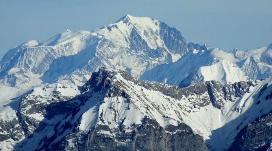
Peak Mont Blanc - the highest point in Europe
European states
The political map of Europe shows that there are about 50 states on this territory. It is worth noting that only 43 states are officially recognized by other countries; five states are located in Europe only partially, and two countries have limited or no recognition by other countries.
Europe is often divided into several parts: Western, Eastern, Southern and Northern. Western European countries include Austria, Belgium, United Kingdom, Germany, Liechtenstein, Ireland, France, Monaco, Luxembourg, Switzerland and the Netherlands.
On the territory of Eastern Europe are Belarus, Slovakia, Bulgaria, Ukraine, Moldova, Hungary, Czech Republic, Poland and Romania.

Political map of Europe
On the territory of Northern Europe are the Scandinavian countries and the Baltic countries: Denmark, Norway, Estonia, Latvia, Lithuania, Sweden, Finland and Iceland.
Southern Europe is San Marino, Portugal, Spain, Italy, Vatican, Greece, Andorra, Macedonia, Albania, Montenegro, Serbia, Bosnia and Herzegovina, Croatia, Malta and Slovenia.
Countries such as Russia, Turkey, Kazakhstan, Georgia and Azerbaijan are partly located in Europe. The unrecognized entities include the Republic of Kosovo and the Pridnestrovian Moldavian Republic.

Danube river in Budapest
European politics
In the field of politics, the following European states are the leaders: France, Germany, Great Britain and Italy. Today, 28 European states are part of the European Union - a supranational association that determines the political, trade and monetary activities of the participating countries.
Also, many European countries are part of NATO - a military alliance in which, in addition to European countries, the United States and Canada take part. Finally, 47 states are members of the Council of Europe, an organization that implements programs to protect human rights, protect the environment, etc.

Events on the Maidan in Ukraine
For 2014, the main hotbeds of instability are Ukraine, where hostilities unfolded after Russia annexed Crimea and the events on the Maidan, as well as the Balkan Peninsula, where the problems that arose after the collapse of Yugoslavia have not yet been resolved.
Foreign Europe is a part of the European continent and several islands, covering a total area of about 5 million square meters. km. It is home to about 8% of the world's population. Using a map of Foreign Europe by geography, you can determine the size of this region:
- from north to south, its territory occupies 5 thousand km;
- from east to west Europe stretches for almost 3 thousand km.
The region has a fairly diverse topography - there are flat and hilly territories, mountains and coastal coasts. Due to this geographical location, various climatic zones are represented in Europe. Abroad Europe is in a favorable geographic and economic position. It has been conventionally divided into four areas:
- western;
- eastern;
- northern;
- southern.
Each of the regions includes about a dozen countries.

Rice. 1. Overseas Europe is shown in blue on the map
Driving from one end of Europe to the other, you can visit the eternal glaciers and subtropical forests.
Countries of Foreign Europe
Foreign Europe was formed by four dozen countries. There are other countries on the European mainland, but they do not belong to Foreign Europe, but are part of the CIS.
TOP-4 articleswho read along with this
Among the countries there are republics, principalities, kingdoms. Each of them has its own natural resources.
Almost all countries have maritime borders or are located at a short distance from the sea. This opens up additional trade and economic routes. The countries of Foreign Europe on the map are mostly small. This is especially noticeable in comparison with Russia, China, the United States and Canada. However, this does not prevent them from being one of the most highly developed in the world.

Rice. 2. Countries of Foreign Europe
Almost the entire population belongs to the Indo-European group, with the exception of emigrants from other countries. Most of the population preaches Christianity. Europe is one of the most urbanized regions - which means that cities are home to about 78% of the total population.
The table below shows European countries and capitals, with an indication of the number of inhabitants and the area of the territory.
Table. Composition of Foreign Europe.
|
Country |
Capital |
Population, million people |
Area, thousand sq. km. |
|
Andorra la Vella |
|||
|
Brussels |
|||
|
Bulgaria |
|||
|
Bosnia and Herzegovina |
|||
|
Budapest |
|||
|
United Kingdom |
|||
|
Germany |
|||
|
Copenhagen |
|||
|
Ireland |
|||
|
Iceland |
Reykjavik |
||
|
Liechtenstein |
|||
|
Luxembourg |
Luxembourg |
||
|
Macedonia |
|||
|
Valletta |
|||
|
Netherlands |
Amsterdam |
||
|
Norway |
|||
|
Portugal |
Lisbon |
||
|
Bucharest |
|||
|
San marino |
San marino |
||
|
Slovakia |
Bratislava |
||
|
Slovenia |
|||
|
Finland |
Helsinki |
||
|
Montenegro |
Podgorica |
||
|
Croatia |
|||
|
Switzerland |
|||
|
Stockholm |
|||
As you can see, the geographical picture of Europe Abroad is very diverse. The countries that make up it can be divided into several groups according to their location.
- Inland, that is, without borders with the sea. This includes 12 countries. Examples - Slovakia, Hungary.
- Insular, or completely located on islands, are 4 countries. Example - Great Britain.
- Peninsular are located in whole or in part on the peninsula. For example, Italy.

Rice. 3. Iceland is one of the island states of Europe
The most highly developed economically and technically are four European countries - Italy, Great Britain, Germany, France. They are part of the G7 along with Canada, Japan and the United States.
What have we learned?
Foreign Europe is a relatively small area of the European continent, which includes 40 countries. Most of them have maritime boundaries, some are located on the islands. The geographical location of European countries is favorable in most cases. Abroad Europe has a connection with the whole world.
Test by topic
Assessment of the report
Average rating: 4.7. Total ratings received: 120.
The map of Europe shows the western part of the continent Eurasia (Europe). The map shows the Atlantic, Arctic oceans. Seas washed by Europe: North, Baltic, Mediterranean, Black, Barents, Caspian.
Here is a political map of Europe with countries, a physical map of Europe with cities (capitals of European countries), an economic map of Europe. Most of the maps of Europe are presented in Russian.
Large map of European countries in Russian
All countries and cities of Europe with their capitals are marked in Russian on a large map of European countries. Highways are indicated on a large map of Europe. The map shows the distances between major cities in Europe. The map in the upper left corner is a map of the island of Iceland. The map of Europe is made in Russian on a scale of 1: 4500000. In addition to the island of Iceland, the islands of Europe are shown on the map: Great Britain, Sardinia, Corsica, Balearic Islands, Maine, Zealand Islands.
Map of Europe with countries (Political map)
On the map of Europe with countries, on the political map, all the countries of Europe are plotted. The countries shown on the map of Europe are: Austria, Albania, Andorra, Belarus, Belgium, Bulgaria, Bosnia and Herzegovina, Vatican, Great Britain, Hungary, Germany, Greece, Denmark, Ireland, Iceland, Spain, Italy, Latvia, Lithuania, Liechtenstein, Luxembourg, Macedonia, Malta, Moldova, Monaco, Netherlands, Norway, Poland, Portugal, Russia, Romania, San Marino, Serbia, Slovakia, Slovenia, Ukraine, Finland, France, Croatia, Montenegro, Czech Republic, Switzerland, Sweden and Estonia. All designations on the map are in Russian. All European countries are marked with their borders and main cities, including capitals. The political map of Europe shows the main ports of the countries of Europe.
Map of European countries in Russian
On the map of the countries of Europe in Russian, the countries of Europe, the capitals of the countries of Europe, the oceans and seas washing Europe, the islands: Faroe, Scottish, Hebrides, Orkney, Balearic, Crete and Rhodes are shown.
Physical map of Europe with countries and cities.
On the physical map of Europe with countries and cities, the countries of Europe, the main cities of Europe, European rivers, seas and oceans with depths, mountains and hills of Europe, lowlands of Europe are indicated. The largest peaks of Europe are plotted on the physical map of Europe: Elbrus, Mont Blanc, Kazbek, Olympus. Separately highlighted maps of the Carpathians (scale 1: 8000000), map of the Alps (scale 1: 8000000), map of the Strait of Gibraltar (scale 1: 1000000). On the physical map of Europe, all designations are in Russian.
Economic map of Europe
Industrial centers are marked on the economic map of Europe. The centers of ferrous and nonferrous metallurgy in Europe, centers of mechanical engineering and metalworking in Europe, centers of the chemical and petrochemical industries in Europe, centers of the forest industry, centers for the production of building materials in Europe, centers of light and food industries are marked. On the economic map of Europe, the lands with the cultivation of various crops are highlighted. The map of Europe shows mining sites, power plants in Europe. The size of the mining icon depends on the economic importance of the deposit.
In the East and South-East (on the border with Asia) border of Europe the ridge of the Ural Mountains is considered. The extreme points of this part of the world are: in the North - Cape Nordkin 71 ° 08 'north latitude. In the south, the extreme point is considered Cape Maroki, which is located at 36 ° north latitude. In the west, the extreme point is considered to be Cape of Fate, located 9 ° 34 'east longitude, and in the east - the eastern part of the foothills of the Urals up to about Baydaratskaya lip located at 67 ° 20 'east longitude.
The western and northern coasts of Europe are washed by the North, Baltic Sea and the Bay of Biscay, and the Mediterranean, Marmara and Azov - cut deeply into from South. The seas of the Arctic Ocean - Norwegian, Barents, Kara, White - wash Europe in the far north. In the southeast there is an endless Caspian Sea-lake, formerly part of the ancient Mediterranean-Black Sea basin.
Europe is part of the world, most of which is in the Eastern Hemisphere. The Strait of Gibraltar separates it from Africa, the Bosphorus and the Dardanelles from Asia, the eastern and southeastern conventional border runs along the eastern foothills of the Urals and along the main Caucasian ridge.
Europe as a continent is characterized by the following features. Firstly, it is a large single monolith with Asia and therefore the division into Europe is more of a historical than a physical-geographical character. Secondly, it is relatively small in area - about 10.5 million square kilometers. (together with the European part of Russia and Turkey), that is, large from Canada by only 500 thousand square kilometers. Only Australia is smaller than Europe. Thirdly, a significant part of the territory of Europe consists of peninsulas - Iberian, Apennine, Balkan, Scandinavian. Fourth, the mainland of Europe is surrounded by fairly large islands (Great Britain, Spitsbergen, Novaya Zemlya, Iceland, Sicily, Sardinia, etc.), which significantly expand its territory. Fifthly, Europe is the only continent that does not occupy the tropical zones, which means that the natural diversity of climatic zones and vegetation zones is somewhat lower here.
Europe has been and remains an important macro-region in the political, economic and cultural life of the entire planet.
There are 43 independent states located within Europe. In terms of the size of the territory, they are small and rather compact. The largest states in Europe are France, Spain, Sweden, which occupy an area of 603.7; 552.0; 504.8; 449.9 thousand km2. is a Eurasian power, occupying an area of 17.1 million km2. Only twelve countries have an area from 100 to 449 thousand km2. 19 countries have an area of 20 to 100 thousand km2. The smallest area is occupied by the so-called countries - the dwarfs Vatican, Andorra, Monaco, San Marino, Liechtenstein, Luxembourg, Malta.
All European countries, with the exception of the Vatican, are members of the United Nations.
For a long time, Europe of the XX century. was divided into two parts - East and West. The first included the former so-called socialist countries (Central-Eastern or Central and Eastern Europe), and the second - capitalist (Western Europe). The events of the late 80s and early 90s radically changed the character of the modern era. The collapse of the socialist system led to the unification of the German lands into a single state (1990), the formation of independent independent states on the territory of the former Soviet Union (1991), the collapse of the Socialist Federal Republic of Yugoslavia (SFRY) in 1992, Czechoslovakia in 1993.All this should not only be political, but also of great economic importance. Central-Eastern and Eastern Europe, as well as the countries of the Adriatic-Black Sea sub-region, are gradually creating a market economy.
The new phase of detente, which began in the late 1980s and early 1990s, created a completely new situation. The idea of a common European home from the Atlantic to the Urals has become an objective reality. Conditions have been created for the existence of various forms of integration in various regions of Europe, including Central-Eastern and Eastern Europe. The first such "swallow" in the new Europe was an attempt to create an interstate association back in the early 1990s, which the neighboring states of Austria, Hungary, Italy and the former Czechoslovakia and Yugoslavia called the "Pentagonalia" (now "Octagonal"). This combination of states with different political and socio-economic status has shown that neighboring states have many common problems (environmental protection, energy use, cultural cooperation, scientific and technological progress). After the collapse of the CMEA, a geopolitical vacuum arose in Central and Eastern Europe. The countries are looking for a way out of it in regional and subregional integration. So, in February 1991, the Visegrad subregional association arose as part of Poland, Hungary and the former Czechoslovakia, which pursued the goal of accelerating the entry of these countries into the common European integration processes.
Shores of europe heavily indented by bays and straits, there are many peninsulas and islands. The largest peninsulas are Scandinavian, Jutland, Iberian, Apennine, Balkan and Crimean. They occupy about 1/4 of the total area of Europe.

The area of the European islands exceeds 700 thousand km2. These are Novaya Zemlya, Franz Josef Land archipelago, Svalbard, Iceland, Great Britain, Ireland. In the Mediterranean Sea there are such large islands as Corsica, Sicily, Sardinia.
In the waters washing the shores of the European land, transport routes cross that lead to Africa and America, and also connect the countries of Europe with each other. In the south-east is the undrained Caspian Sea - lake.
Coast of strongly indented bays and straits, there are many peninsulas and islands.The largest peninsula - Scandinavian, Jutland, Iberian, Apennine, Balkan and Crimea.They occupy about 1/4 of the total area of Europe.
European islands area exceeds 700 km2.This Novaya Zemlya archipelago of Franz Josef Land, Spitsbergen, Iceland, UK, Ireland.In the Mediterranean, there are such large islands as Corsica, Sicily, Sardinia.
In the waters around the coast of the European land transport cross paths that lead to Africa and America, as well as bind Europe together.