Andes: Amazing Mountains. The Incas - the ancient inhabitants of the mountains
Read also
The Andes, not to be confused with the Cordilleras (link to the article on the Cordilleras) - the longest (9000 km) and one of the highest (Mount Aconcagua, 6962 m) mountain systems of the Earth, bordering all of South America from the north and west; southern part of the Cordillera. In some places, the Andes reach a width of over 500 km (the greatest width - up to 750 km - in the Central Andes). The average height is about 4000 meters.
With glaciers on the limbs, active volcanoes along the ridge, chains of high snow-capped peaks, humid and dry tropical forests inside, deserts and savannahs in the lowlands and alpine tundra, the Andes is an extraordinary world of varied landscapes, extreme temperatures and diverse wildlife. Towering over the Pacific coast, this 5,000-mile long mountain range spans seven countries, from Tierra del Fuego in the harsh south to the Caribbean coast in the north. It is home to some of the tallest, saltiest, wettest, and driest landscapes on the planet. Penguins, possums, hummingbirds, llamas, cougars, foxes, condors, spectacled bears, and many other species of wild animals inhabit these unlike worlds, which are called the Andes.
Due to the considerable extent of the Andes, their individual landscape parts differ significantly from each other. By the nature of the relief and other natural differences, as a rule, three main regions are distinguished - the Northern, Central and Southern Andes.
The name of the Andes is most often explained from the Inca word anta - "copper". This etymology is supported by the presence of a "copper belt" in the Andes, stretching for almost 4 thousand km, and the ability of the ancient Incas to smelt copper. According to another etymology of the Andes - from Quechua anti - "east", which supposedly indicated the position of the mountains relative to Cuzco, the ancient capital of the Incas.
The Andes are a large interoceanic watershed; to the east of the Andes, the rivers of the Atlantic Ocean basin flow (the Amazon itself and many of its large tributaries, as well as the tributaries of the Orinoco, Paraguay, Parana, the Magdalena River and the Patagonia River, flow in the Andes), to the west - the Pacific Ocean basin (mostly short).
Given the wide variety of different mountain peaks, both in height and in the level of difficulty of climbing, the Anda are the most popular place for trekking and mountaineering among non-professionals, and the five highest peaks of the Andes look like this:
6962 meters - Aconcagua, Argentina
6,891 meters - Ojos del Salado, Chile
6792 meters - Monte Pissis, Argentina
6770 meters - Mercedario, Argentina
6768 meters - Huascaran, Peru
The highest volcano is Llullaillaco (Spanish: Llullaillaco), its 6,723 meters, located simultaneously in Argentina and Chile. But it's easier to climb Cotopaxi (Spanish: Cotopaxi), located in Ecuador and having 5897 meters.
Of the most affordable six-thousanders in terms of money and complexity, I would single out
I have always been in awe of the sky-propping mountain peaks bathed in sunlight. Mighty, monumental, unshakable Atlanteans breathing tranquility. And if I am faced with a choice between the sea, the forest and huge stone masses, I will not hesitate to prefer the latter. Better than mountains can only be mountains!
And there are few places on the planet where I have experienced such inspiration as near the majestic Andes. Part of the Cordillera mountain system, which divided the planet in half from the northernmost extremities of Canada almost to Antarctica itself, the Andes proudly bear the responsibility to keep the waters of the Pacific and Atlantic oceans from mixing in the southern hemisphere. The highest, longest, youngest mountains in the world. Rising to a height of almost 7000 meters, strewn with sleeping and waking volcanoes, this huge prehistoric creature stretches for 9000 kilometers and plunges its southern edge into rough waters, forming an intricate pattern of straits and glaciers, where ships died for centuries. The Andes keep many secrets, mysteries and dangers: somewhere the gold of the Incas is hidden, somewhere the planes died.
This is where I come back every time an airline like Iberia, Lufthansa or Turkish Airways announces a sale.
Northern Andes
In the north, the Andes rise above the tropical rainforests of Venezuela, Colombia and Ecuador, they have a difficult character: the altitude of 4500-6000 meters and changeable weather require special skills from the tourist. But you can choose an easier option: rent a car and go around the foothills of volcanoes and lakes, or take a ride on the longest cable car in the world (almost 2 kilometers) Teleferico de Merida in Venezuela.
Central Andes
In the territory of Peru and Bolivia, the Andes keep in their depths vast and fertile plateaus on which the Inca cities were once built. But for me the main treasures of these places are alpine lakes, full-flowing like Titicaca and turned into salt marshes like. You can spend some amazing days studying the customs of the people of Taquile on Titicaca, where men knit from colored wool. Or spending the night on the reed islands of the Uros under the huge and bright stars at an altitude of 3800 meters. Or sweeping with the breeze through a huge pit of salt. Or coming up with the most incredible compositions for photography in a place where there is no perspective. And, of course, enjoying the most memorable sunsets of your life.
South Andes, Carretera Austral
A long and narrow strip of land called Chile and the endless Argentine pampas stretch along the Andean ridges, the tops of which are clinging to clouds. Moreover, they cling in the literal sense: the rain clouds driven by the Pacific winds cannot overcome the mountain barrier and shed precious moisture on the southern Chilean side (northern Chile, with the world's driest desert, the Atacama, is not so lucky). The famous road built in the mid-1970s under Pinochet, the Carretera Austral, or "southern road", winds here. This is one of the most picturesque and interesting routes that I have ever traveled, it gives the opportunity for 1240 kilometers to fully enjoy the beauty of mountain peaks, turbulent rivers, azure lakes and proud pines.
It is better to travel during the summer months (December to February), as ferry crossings are closed at other times of the year and you will not be able to enjoy all the beauty of the trip. Therefore, feel free to plan a big vacation for the January holidays and then, in addition to the famous South Road, you can see the huge Perito Moreno glacier, breathe in the famous Patagonian winds and find out why Tierra del Fuego is called that. By the way, the Northern and Central Andes are friendly to travelers all year round.
Where to start
The starting point of Carretera Austral is the Chilean city of Puerto Montt. It is a cute little village imbued with a European spirit, from where tourists, admiring the old mahogany cathedral, go to the Lake District, to the Villarrica volcano or to the island of Chiloe. Here you have to decide in what way you will conquer the South Road: the most daring go hitchhiking or on bicycles, and the rest rent a car.
From Chiloe Island, you can take a ferry to the town of Chaiten and move either north or south.
Another option is to start in the south, from the village of Villa O "Higgins, which can be reached by ferry from Argentina, which runs several times a week from November to March and takes only pedestrians or cyclists on board (it costs about $ 60, or 40,000 pesos) , or entrusting itself to the care of a travel company, which will not only arrange for delivery by the ferry by bus, but will also offer to see the glaciers on the lake "on the way" (the tour will cost from $ 130).
What to take with you
- Regardless of which way of transportation you choose, you need to have a supply of food with you, you will find supermarkets only in relatively large settlements, in other settlements there are only village shops with a minimum set of products.
- Don't forget the medication and essentials you need (from plaster to toothpaste and repellents). Carretera Austral is not a place where you can take only your passport and credit card.
- Comfortable clothing and footwear are a must, as there are so many stunning and inviting places to explore!
- There is enough cash in local currency (Chilean pesos), you will not find ATMs until Coyaic, and cards are not accepted anywhere.
If you decide to hike or bike
Since the distances between settlements and campsites are long, you will need:
- tent,
- sleeping bag (even in summer the nights are cold in the mountains),
- gas-burner,
- a pot and dishes,
- and other camping equipment.
You can rent everything you need, including a bicycle, in Puerto Monte (the choice is very scarce, and the prices are very high) or in Santiago, where there are a huge number of rentals with good bicycles. To do this, you will need to present a passport and a bank card to hold the deposit (depending on the rental period from $ 250). The rental price starts at $ 30 per day or $ 120 per week.
If you decide to travel by car
You can rent a car in Puerto Monte or, as I did, in Santiago (in this case, you will need to lay a few days to drive along the magnificent highway for almost 1000 kilometers, stopping at wineries and visiting national parks).
- Prepare, in addition to your usual license, international license (some rental agencies do not issue a car without them) and, of course, a bank card with a sufficient amount in the account to block the deposit.
- Explore the sites of rental offices to choose the most suitable option. Do not watch small cars, only four-wheel drive! If possible, give up the options for cars that seem to have just come out of the passenger compartment, choose a car that has passed the baptism of fire, because small stones will inevitably fly on the gravel road.
- South of Carretera, the Austral Andes are full of many magnificent landscapes, for example, you can admire the famous Fitzroy peak and the beauty of the Torres del Paine National Park. But, since some parts of the country are occupied by impassable mountains, part of the empty will have to be done through the territory of Argentina. To do this, you will need special documents for the car. Be sure to contact the rental agency in advance - the documents for crossing the border take several days, and be prepared for the fact that you will be charged a fee of $ 200 for registration.
- Gas stations along the way are rare, so take every opportunity to replenish your gasoline supplies.
So, you've saddled a four-wheeled beast (for example, I got a red pickup with someone playing tic-tac-toe with a nail on the hood) and are ready for adventure.
By sea
At the very beginning of the journey, three ferries will be waiting for you, which will go around the inaccessible, densely forested mountain slopes by the sea (see the map below). The first ferry departs from La Arena every hour and costs about $ 15 (10,000 pesos) per car. In half an hour you will reach the peninsula, which can only be reached by sea. The second ferry departs from Ornopien (there are several shops and you can stay overnight), located at the southern end of the peninsula, twice a day - in the morning and in the afternoon. It is better to check the schedule in Puerto Monte. This ferry takes 5 hours, a ticket costs 54 $ (35,000 pesos), and this price includes the third ferry, which departs when all passengers of the second ferry have safely overcome 10 kilometers of gravel road.
By land
As a result of all the sea voyages, during which the majestic mountains, forests and waterfalls will float by, you will find yourself in the village of Kaleto Gonzalo. From here, boldly head south, stopping in scenic spots and climbing deep into the mountains. Your travel speed will average 50 km / h, so don't miss the signs for recommended hiking trails to especially beautiful and amazing natural treasures and numerous national parks.
Carretera Austral ends with a dead end in the village of Villa O "Higgins, from where you can cross to Argentina (only those who travel on foot or by bike are taken on the ferry), or return back if you are traveling by car.
Where to go
All along the South Road you will find several opportunities to cross the border with Argentina: at the village of Santa Lucia, next to the Lago las Torres park, the town of Coyachi and before reaching Cochrane. I would highly recommend the latter option, as you will not only be able to see almost the entire Carretera Austral, but also drive past the magnificent lake, which in the Chilean part is called Lago General Carrera, and in the Argentine part - Lago Buenos Aires.
Tourist infrastructure
You can spend the night in campings, which are scattered along the entire Carretera Austral, or in settlements. Almost all locals rent rooms from $ 10 to $ 55 (8000-35000 pesos) for a night for two and will be happy to feed you breakfast (and not always at an additional cost). Free campings are just cleared areas. Those equipped with a toilet, hot shower and awnings will cost from $ 5 to $ 10 per night.
For example, on January 2, I stopped in the picturesque village of Via Cerro Castillo, where the whole large family of owners gathered for dinner in the evening. Despite my limited knowledge of Spanish, I was invited to share a meal with everyone and enjoy a wonderful evening. The men prepared a traditional dish - they roasted a young lamb on the cross - a la cruz, and the women cut fresh vegetables and herbs. It was the tastiest lamb I have ever tasted in my life. And the glare of the fire on their open and benevolent faces, songs to the accordion and majestic mountains under the canopy of the starry sky were forever engraved in my memory.
Catering establishments are found only in the largest settlements: Ornopirene, Koyaki, Cochrane. Elsewhere, the best you can count on are small grocery stores. I usually tried to have a hearty breakfast and dinner where I slept (if the owners did not cook, I asked permission to use the kitchen), and during the day, pre-prepared sandwiches helped me out.
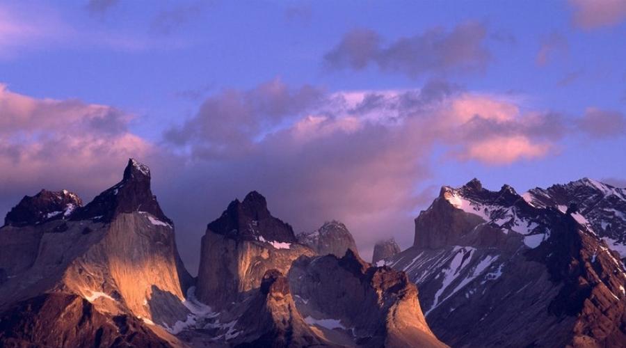
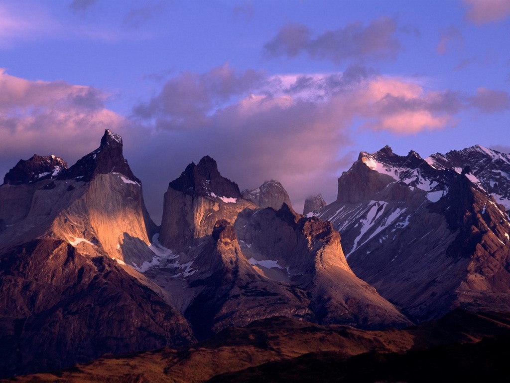
Southern Andes, Patagonia and Tierra del Fuego
On the western edge of the Patagonian steppes rise the Southern Andes. They are no longer as high as in the north, but that is why they are no less beautiful. Along the entire foothills of the mountains, there are delightful natural reserves, the main pearls of which are the giant Perito Moreno glacier, one of only two on planet Earth that does not shrink but grow, and the Torres del Paine Park, whose rugged beauty attracts travelers from all over the world. What miracles Patagonia has prepared and how to get to them is well written.
And further south, the red grass of Tierra del Fuego rustles in the wind, where, according to legend, the giants lived, and the Andes lower their tail strewn with peaks into the ocean, from which glaciers slide down in caps. Here, like the last stronghold of the mountains, Cape Horn rises from the water, landing on which is good luck. Between this lonely lighthouse outpost and Argentina, few ships and violent cold currents wander.
The Andes are many-sided and unpredictable, they fascinate and fall in love, seeing them at least once, you will come back again and again. After all, only the Andes can be better than mountains!
Many people wonder where the Andes are located: on which continent, in which climatic zones, on the territory of which states. Also, some readers would like to know about the time of origin of these great mountains, their nature and population. All this will be discussed in this article.
Geographical position
The Andes are the longest mountain system in the world. It borders the north and west of South America and extends for 9000 km. The width of the mountains is no less impressive: about 500 km on average, and the maximum is 750 km.
The Andean Cordillera, as this mountain system is also called, is a natural natural barrier separating the territory of South America from the Atlantic. This is also a major watershed: the rivers of the Atlantic Ocean basin flow from the eastern side, and the Pacific Ocean from the western side. High in the mountains originate the tributaries of the Amazon, Orinoco, Paraguay, Parana, as well as many waterways of Patagonia.
The territory of the Andes covers seven countries of South America: Venezuela, Peru, Bolivia, Chile, Colombia, Argentina, Ecuador.
Weather
Due to their enormous length, the ridges and spurs of these great mountains spread over several climatic zones.
The Northern Andes are dominated by subequatorial latitudes with a distinct alternation of rainy and drought seasons.
The tropical zone is characterized by constant values of both temperature and humidity: there are no sharp changes here. These are the conditions in the Caribbean Andes. There is also no seasonality at the equator, but the differences in climate in height are pronounced: at the foot it is humid and hot, at the peaks there is snow.

The central part is divided along slopes: precipitation from the west is an order of magnitude less than from the east. There is a zone of tropical deserts with frequent fogs and dews. The average annual temperature on the Pune and Altiplano plateaus does not exceed 10 ° C, and the conditions here are harsh: abrupt weather changes and strong gusty winds are the norm.
In the south, in the Tierra del Fuego region, a humid oceanic climate prevails. The annual rainfall exceeds 3,000 mm. They fall mainly in the form of a nasty drizzling rain that does not stop most of the days of the year.
How did they form?
Any schoolchild can show where the Andes are located on the physical map of the world. A complex chain of parallel ridges has been forming for millions of years. According to scientists, the Andes mountain system, where the subduction zone is located, has been transforming and transforming so far. The Antarctic tectonic plate and Nazca gradually go under the South American plate.
Geologists at the University of Bristol have established the approximate time for the beginning of the rise of the mountains. They used a new modern method based on the study of cosmogenic helium-3, which is formed in mineral layers under the influence of cosmic radiation.

British scientists analyzed stones at an altitude of about 2 km in the western part of the mountain range. After numerous studies, they came to the conclusion that the Andes, where these boulders are located, were about 15 million years ago at about the same level as they are now. The slopes gradually rise due to the thickening of the earth's crust at the point of contact of the lithospheric plates.
The mainland, where the Andes mountains are located, is still in continuous motion. This is imperceptible to us, however, when powerful earthquakes and volcanic eruptions occur, the planet recalls the processes taking place in its womb.
Vegetable world
The flora of these places directly depends on the altitudinal zonation. The Caribbean Andes are characterized by deciduous forests and shrubs. The eastern slopes are covered with impenetrable tropical jungle, while in the west there are deserts and dry cereal steppe regions. In the highlands of equatorial latitudes, meadows predominate.

The Andes, where the land is so different in moisture and temperature indicators, is considered the birthplace of many cultivated plants, including potatoes, coca and cinchona, which from time immemorial served as a powerful treatment for malaria.
Animal world
The fauna of the mountainous regions is similar to the adjacent plains. Among the endemics it is necessary to abolish vicunas and guanacos, spectacled bear, chinchillas, Chilean possum, Azarov fox, Magellan's dog.

The Andes Mountains, home to 88 national parks, are home to many birds. In mountainous areas, you can find condors, partridges, hummingbirds, several species of geese and ducks, flamingos and parrots.
Highest point
Aconcagua is the tallest extinct volcano in the world. This mountain peak, located in the central part of the Andes in the territory of modern Argentina, is the highest not only in its system, but on the entire continent, as well as in the Southern and Western Hemisphere.

According to one version, the name of the peak comes from the ancient Quechua language and translates as "stone guard".
In terms of mountaineering, Aconcagua is a fairly easy peak to climb, especially its northern slope. The shortest time it takes to climb the top (6962 m) was recorded in 1991 and amounted to 5 hours and 45 minutes.
The first person to climb the Stone Guard was the Swiss Mathias Zurbriggen. It happened on January 14, 1897 as part of the expedition of the Englishman Edward Fitzgerald.
The Incas - the ancient inhabitants of the mountains
The extinct Inca civilization lived in these mountainous regions many millennia ago. They gave the name to the Andes. In translation from their ancient language "anta" means "copper mountains". And this name is not accidental: the largest belt with the richest deposits of this metal is located here.
Numerous tourists climb high into the Andes, where there are cultural monuments of this mysterious civilization that have survived to this day.
The most famous cult site is the Machu Picchu complex of structures lost among endless canyons and rocks. The sacred abode of the ancient people was erected on the top of the ridge, located at an altitude of 2.5 km above sea level. And although in translation its name sounds like "old peak", the Incas called Machu Picchu "city in the clouds".

In 1532, when the Spanish came to the land belonging to the Incas, the city was mysteriously deserted. Where the inhabitants of Machu Picchu disappeared is still unknown. According to one of the legends, the city was covered with a huge cloud, which took the Indians with them.
The Andean West subcontinent occupies the entire western part of the continent. It is the longest (9 thousand km) and one of the highest mountain systems of the continental land. The width of this mountain system reaches 500 km. In general, the Andes covers an area of about 3,370,000 km². The Andes mountains face the wide front, in the north - to the Caribbean Sea. The eastern border with the countries of the East Andean runs along the foot of the Andean ridges. The unity of the physical and geographical countries of the subcontinent is due to the fact that they are located within the fold belt at the border of the lithospheric plates of the Pacific Ocean and South America.
A complex system of orotectonic zones of predominantly submeridional strike is sustained from the northern coast of the mainland to. Ranges of different ages Coastal, Western and Eastern Cordilleras stretch across the entire mountain system of the Andes. Mountain-forming, especially active in the Paleogene and Neogene, continue to this day, accompanied by volcanic processes and earthquakes.
It unites the region and the position in the west of the continent, limiting the influence of the Pacific Ocean on the inner regions of the system and creating a contrast in the natural conditions of the western and eastern macroslopes.
Alpine relief dominates in the Andes, which determines a pronounced altitudinal zonation and the formation of significant modern glaciation. The huge length from north to south causes a big difference in heat supply and in moisture of individual parts of the system: the Andes mountains are located in several climatic zones, therefore, the structure of the altitudinal zonation is also different. The orotectonic structure is also different.
Despite the mountainous nature of the subcontinent, its territory has long and rather densely populated. The peoples of the Andean countries have mastered the basins, intermontane valleys and high plains within the Andean mountain system and adapted to life in these conditions. The Andes is home to the highest mountain towns, villages and arable lands.
Within the Andes, a number of physical and geographical countries are distinguished: the Caribbean, Northern (Equatorial), Central (Tropical), Chilean-Argentine (Subtropical) and Southern (Patagonian) Andes. Tierra del Fuego is distinguished by some special features - this region is either considered as a separate country, or included in the Southern Andes.
Caribbean Andes Mountains
The Caribbean Andes Mountains are the northernmost part of the Andes Mountains and the only one where the ridges have a sub-latitudinal strike. Here the Andes mountains stretch for 800 km along the northern coast of the Caribbean Sea from the river delta. Orinoco to the Maracaibo lowlands. In the south, the region is bordered by the Orinoco plains, in the west, the ridges of the Caribbean Andes are separated from the Cordillera de Merida in the Eastern Andes by a tectonic valley occupied by one of the tributaries of the river. Apure. Unlike other parts of the Andean mountain system, the Caribbean Andes are formed within the Caribbean-Antilles fold area, which may represent the western part of the ancient Tethys Ocean and moved here as a result of the opening of the North Atlantic depression. The region is located on the border of the tropical and subequatorial zones in the zone of action of the northeastern trade winds. Its nature is significantly different from the rest of the Andes mountains. This is the territory of Venezuela.
The relief of the country, in comparison with other Andean regions, is simple in structure: these are young folded mountains, consisting of two parallel anticlinal ridges (Cordillera da Costa - Coastal Range and Sierrania del Interior - Inner Range), separated by a synclinal longitudinal depression. It contains Lake Valencia - one of the few closed lakes on the mainland.
Folded structures are broken by transverse and longitudinal faults, so the mountains are divided into blocks by tectonic and erosional valleys. Frequent earthquakes testify to the youth and incompleteness of mountain building, but there are no active ones here. The height of the Caribbean Andes does not reach 3000 meters. The highest point (2765 meters) is located in the Coastal Cordillera near Caracas, the capital of Venezuela.
The region is exposed throughout the year to tropical air masses, which come here from the northeast trade winds. Only the southern slopes of the mountains in summer fall into the zone of influence of the equatorial monsoon.
In winter, when the trade wind flow weakens slightly, and the southwestern monsoon is replaced by the winter northeastern one, a relatively dry period sets in. Since precipitation is mainly orographic, its amount on the coast and leeward slopes of the mountains is small - 300-500 mm per year. Windward slopes are obtained in the upper zones up to 1000-1200 mm. In the region, the temperature amplitudes are very small - 2-4 ° С. Caracas, located in a transverse valley at an altitude of 900-1000 meters, is called the city of "eternal spring".
The Andes Mountains are cut through by numerous deeply incised valleys of short, turbulent rivers that carry a mass of debris onto the coastal plain, especially in the summer during the rainy season. There are karst areas that are practically devoid of surface water.
The region is dominated by xerophytic vegetation. Monte formations (mesquite bush, cacti, milkweed, prickly pears, etc.) are widespread at the foot of the mountains and in the lower belt. On the low-lying coast, mangroves are common along the shores of the lagoons. On the mountain slopes above 900-1000 meters, rare mixed forests of evergreen, deciduous and coniferous trees grow. In some places they are replaced by xerophytic shrub thickets of the chaparral type. The groves of palms stand out as bright spots. Above, there are meadows, often bushy. The upper border of forests is artificially lowered, since meadows are used as pastures, and in the border part of forests in conditions that are extreme for woody vegetation, it gradually disappears and does not recover.
The coastal strip and intermontane troughs of the Caribbean Andes are oil-bearing. The entire Caribbean coast with sandy beaches, hot dry climate with stable weather conditions is a wonderful resort area. On the gentle slopes of the mountains and in the valleys, coffee, cocoa, cotton, sisal, tobacco, etc. are grown. Cattle are grazed on mountain meadows.
This part of Venezuela is quite densely populated. In the region of Caracas, the population density is over 200 people / km 2. Major cities and ports are located here. Nature has been largely modified by various human activities: flat areas and more or less gentle slopes have been plowed up, forests have been destroyed, and the coastal strip has been transformed. A network of national parks has been created here, used for landscape protection and tourism.
Northern Andes Mountains
This is the northernmost part of the Andean system proper, stretching from the Caribbean coast to 4-5 ° S. NS. The eastern border with the Orinoco plains runs along the foot of the Andes Mountains, and the southern border is drawn along transverse tectonic faults. Approximately in the same area is the border of climatic zones - tropical and equatorial with sharp differences in moisture conditions and the structure of altitudinal zonation on the slopes of the western exposure. Within the region are the western regions of Venezuela, Colombia and Ecuador. The lower belts of the western mountain slopes and coastal plains are characterized by a humid hot climate of the equatorial type. But even in areas with subequatorial climatic conditions at a certain altitude above sea level, constantly moist forests grow - gileas, therefore the Northern Andes Mountains are called Equatorial.
The Andes mountains within the region consist of several chains, separated by deep depressions. The northern part of the country has a particularly complex structure.
A narrow, low, highly dissected Coastal Cordillera stretches along the Pacific Ocean, separated from the neighboring zone (Western Cordillera) by the tectonic valley of the river. Atrato. The Western Cordillera begins at the Gulf of Darien and stretches to the borders of the region. The eastern Cordillera branches within the Northern Andes: at about 3 ° N. NS. it is divided into the Central with the Sierra Nevada de Santa Marta massif (up to 5800 meters high) in the north and the East, which, in turn, by two branches (Sierra Perija and Cordillera de Merida) covers an extensive depression with a lagoon Maracaibo. The rake-shaped valley between the Western and Central Cordilleras is occupied by the river. Which, and between Central and Eastern - p. Magdalena. The entire mountainous region is 400-450 km wide. South of 3 ° N. NS. The Western and Eastern Cordillera converge, and within Ecuador the system narrows to 100 km. There is a zone of powerful faults between the mountain ranges. The main peaks of the ridges are, as a rule, extinct and active volcanoes (Cotopaxi, Chimborazo, Sangay, etc.) covered with snow and ice. The region is also distinguished by high seismicity. The epicenters of earthquakes are usually confined to the faults of the intermontane depression.
The region is characterized by a hot, constantly humid climate. The slopes of the Andes mountains facing the Pacific Ocean receive 8,000-10,000 mm per year.
Unstable stratified, forming over warm currents near equatorial latitudes of the ocean, dominates here throughout the year. Climbing the slopes of the ridges, it gives off moisture in the form of heavy rains. The eastern slopes are influenced by the monsoon circulation, but orographic precipitation falls here also in winter, although the annual amounts are slightly less - up to 3000 mm. Even the interior regions are not dry. A short dry season in winter occurs only in the north-east of the region.
In the Northern Andes Mountains, the system of altitudinal belts is most clearly and fully expressed.
The lower belt - tierra caliente ("hot land") with constantly high temperatures (27-29 ° С) and a large amount of precipitation is occupied by gileys, which are almost indistinguishable from the Amazonian selva. Due to unfavorable conditions for humans, the belt is poorly populated. Only in some places at the foot of the mountains forests have been reduced to plantations of sugar cane and bananas. Above 1000-1500 m, the Tierra Templada ("temperate land") begins. It is cooler here (16-22 ° С), precipitation is up to 3000 mm on the windward slopes and 1000-1200 mm on the leeward slopes. This is a belt of evergreen mountain gilea or deciduous evergreen forests with the best living conditions. It is quite densely populated. Most of the population of the Northern Andes lives here, there are large cities, for example, the capital of Ecuador - Quito. More or less gentle slopes are plowed up, they grow a coffee tree, corn, tobacco, etc. The belt is called "coffee" or "eternal spring" belt. Above 2000-2800 meters, there is a tierra fria ("cold earth"). Average monthly temperatures here are 10-15 ° С. It is at these heights that orographic ones are constantly formed, therefore the high-mountainous gilea of low-growing evergreen trees (oaks, myrtle, some conifers) with an abundance of ferns, bamboos, ploons, mosses, lichens is called nephelogyleia ("foggy forest"). There are many lianas, epiphytes in it. Cool weather with constant fog and drizzling rain is unfavorable for life. A few Indian tribes live in the basins, where they grow corn, wheat, potatoes, legumes, and are engaged in cattle breeding. Tierra Elada ("frosty land") begins from a height of 3000-3500 meters. Average monthly temperatures in this zone are only 5-6 ° С, daily amplitudes are more than 10 ° С, there may be night frosts and snowfalls all year round. In the subnival zone, the vegetation of mountain meadows (paramos) is formed from grasses (bearded grass, feather grass), low-growing shrubs and high (up to 5 meters) highly pubescent Compositae with bright flowers. In the periglacial zone, stony placers are widespread, sometimes covered with mosses and lichens. The nival belt starts at an altitude of 4500-4800 meters.
Among the natural resources of the Northern Andes Mountains, there are large reserves of oil in the depressions. Especially rich are the oil and gas bearing basin of the Maracaibo depression, where there are several dozen large deposits, and the tectonic valley of the Magdalena. In the valley of the river. The Caucas mine hard coal, and placer gold and platinum on the Pacific coast. There are also known deposits of iron, nickel, molybdenum, copper ores and silver in mountainous regions. Emeralds are mined near Bogota. The region also has good agro-climatic conditions for the cultivation of tropical crops. There are many valuable tree species in the mountain gilea, including cinchona, cola, balsa with light rotting wood. Long sea voyages were once made on balsa rafts. In our time, the expedition of Thor Heyerdahl passed several thousand kilometers on such a raft across the Pacific Ocean.
The intermontane valleys and hollows of the Northern Andes Mountains at altitudes of 1000-3000 meters are densely populated and developed. Fertile soils are plowed up. In the valleys-grabens and hollows there are large cities, including the capitals of Ecuador (Quito - at an altitude of about 3000 meters) and Colombia (Bogota - at an altitude of about 2500 meters). The nature of the valleys, hollows and mountain slopes of the Tierra templa belt with favorable conditions for humans has been greatly changed. In the 60s and 70s. XX century in Ecuador and Colombia, reserves and national parks have been established to protect and study natural landscapes.
Central Andes Mountains
The central Andes mountains are the largest of the Andean physical and geographical countries. It starts south of 3 ° S. NS. The mountain system is expanding here, between the chains of the Western and Eastern Cordilleras there are high-altitude plains on the middle massif. The total width of the mountainous region reaches 800 km. The southern border is drawn at approximately 27-28 ° S. sh., where the Eastern Cordillera wedges out, and the tropical climate characteristic of the Central Andes Mountains is replaced by a subtropical one. Within the region are the mountainous parts of Peru, Bolivia, northern Chile and northwestern Argentina.
The orotectonic structure is distinguished by the presence of high mountain (3000-4500 meters) plateaus and plateaus - Pun (in Bolivia they are called Altiplano). The hard middle masses, within which these plains were formed, were divided into blocks; magma rose and lavas erupted along the cracks.
As a result, peneplain areas, accumulative plains in relief depressions and lava plateaus with volcanoes are combined here. From the west, the plains are bounded by high, young folded chains of the Western Cordillera with a lot. In the east, the Eastern Cordillera ridges rise on Mesozoic and Paleozoic folded structures, many of whose peaks above 6,000 meters are covered with caps of glaciers and snow. In the south (within Chile), along the coast, the low Coastal Cordillera rises, separated from the Western depressions. One of them is the Atacama Desert.
The climate in most of the Central Andes is characterized by aridity. The coastal part of the region is dominated by the extremely arid and cool tropical climate of the western coasts of the continents (the climate of coastal, "wet" or "cold" deserts, as it is often called). At 20 ° S NS. the average of the warmest months is 18-21 ° С, the annual amplitude is 5-6 ° С. The flow of cold air from the south travels far north over the Peruvian Current, reducing summer temperatures. There is very little precipitation. Within the Central Andes Mountains, this climatic region has the greatest extent from north to south (from 3 ° to 28 ° S) and rises high on the mountain slopes of western exposure.
The largest areas in the region are occupied by areas of high-mountain arid climate with desert and semi-desert landscapes.
The average temperatures of the summer months on the Central Andean high plains are 14-15 ° С, during the day they can rise to 20-22 ° С, and at night fall to negative values. This is due to the thinness and transparency of the mountain air. In winter, the average monthly temperatures are positive, but a large daily amplitude remains, and at night there are frosts down to -20 ° C. The large lake Titicaca has some moderating influence. Not far from it is La Paz - the capital of Bolivia - the highest capital in the world (3700 metro). The amount of precipitation on the Punes is small and increases from west to east - from 250 mm to 500-800 mm. The windward slopes of the Eastern Cordillera get up to 2000mm thanks to the influence.
The soil and vegetation cover of the Central Andes is formed according to the distribution of precipitation and temperature regime.
In coastal deserts, plants adapt to rainless conditions and receive moisture from dews and fogs. Rare xerophytic shrubs and cacti make up a sparse vegetation cover. Characteristic are peculiar bromeliads with hard gray leaves and weak roots and lichens. In some places there is no vegetation; moving sands with sandy and bumpy relief are widespread. Where the annual amount of precipitation (in the form of fogs) reaches 200-300 mm. Lomas plant formations appear, represented by ephemerals and a few perennial grasses and cacti. Lomas come to life in winter, when evaporation decreases, and dry up in summer. The inner plains are dominated by puna - a steppe with a predominance of fescue, reed grass, other poppies and individual low-growing shrubs and trees, for example, thorny puja of bromeliads and kenoas, growing in the valleys. In the western arid regions, semi-deserts with hard grasses, tola shrubs, cushion-like forms of the laret plant, and cacti are widespread. Wormwood and ephedra grow in saline areas, of which there are many. The eastern slopes are characterized by an altitudinal zonation characteristic of the humid regions of the Andes Mountains. Even where the lower mountain belt is adjacent to the dry savannas of Gran Chaco, higher, at the level of formation of orographic clouds, moist mountain gileas of the Tierra Templada belt appear, giving way to the formations of the Tierra Fria and Tierra Elada belts.
The fauna of the Central Andes Mountains is interesting and unusual, rich in endemic species.
Ungulates include guanacos and vicuñas, which are almost extinct at the present time, and the Peruvian deer. There are many rodents (whiskach, chinchilla, acodon, etc.), birds (from tiny hummingbirds in the lomas formation to giant predatory condors). Many animals, including birds, live in burrows, like the inhabitants of the highlands of Tibet.
The subtropical climate of the Pacific coast and the adjacent mountain slopes is distinguished by well-pronounced features of the Mediterranean type: dry summers and rainy winters with average monthly temperatures above zero. With distance from the ocean, the degree of continentality increases, the climate becomes drier.
On the western slopes of the Main Cordillera there is more precipitation, the eastern slopes facing the Pampian Sierras and Dry Pampa are rather dry. On the coast, seasonal temperature amplitudes are small (7-8 ° C), in the Longitudinal Valley, temperature fluctuations are greater (12-13 ° C). The mode and amount of precipitation also change from north to south. On the border with tropical climatic regions, the climate is extremely dry - 100-150 mm per year, and in the south, where the influence of the South Pacific baric maximum is weakened and the western transport of temperate latitudes increases, the annual precipitation reaches 1200 mm with a uniform regime.
The nature of the surface runoff is also different and varies both from west to east and from north to south. In the northern regions of the country, river streams are mostly periodic. In the central part, a rather dense network of rivers with two rises of water is developed - in winter, when it rains, and in summer, when snow and ice melt in the mountains. The river network is especially dense in the south of the region. The rivers here are full-flowing all year round, and the maximum flow occurs in winter. Sometimes they give rise to rivers. In the south, at the foot of the Main Cordillera, there are end lakes, dammed by lavas or moraines.
Natural vegetation in the region is poorly preserved. Under formations of the Mediterranean type, similar to maquis or chaparral, brown soils have formed, suitable for growing subtropical crops, therefore, wherever possible, the land is plowed up. Even more fertile dark-colored chernozem-like soils are developed in the Longitudinal Valley on volcanic rocks. These lands are occupied by agricultural crops.
Only on the mountain slopes, inconvenient for plowing, are the thickets of evergreen xerophytic shrubs preserved - espinal. On the Main Cordillera up the slopes, they are replaced by deciduous and mixed forests, where teak, liter, overeating, canelo, notofagus, honey palm, etc. grow. Above the forests (from a height of 2500 meters), a belt of mountain meadows begins, within which ordinary and for alpine meadows of the Old World, buttercups, saxifrage, primroses, etc. On the arid eastern slope, forests are practically absent. Semi-desert landscapes are also typical for the northern part of the region, including the north of the Longitudinal Valley. In the extreme south, hemigileia appear with a predominance of evergreen noto-phagus on brown forest soils. In the forest belt of volcanic massifs, there are many plants imported from other parts of the world. Artificial tree plantations surround villages and fields.
Land and agroclimatic resources are the main natural resources of the Chilean-Argentinean Andes. They make it possible to grow here crops that are common in the Mediterranean (grapes, citrus fruits, olives, etc.). The fields of wheat and corn are vast. Half of the country's population lives in the Longitudinal Valley, where the capital of Chile, Santiago, is located (the population density here reaches 180 people / km 2), despite the fact that this is a seismic region, where strong earthquakes are frequent. The nature here has been changed to the greatest extent. In Chile and Argentina there are national parks and nature reserves created to protect mountain and lakeside landscapes and natural flora and fauna that have been preserved so far.
South (Patagonian) Andes Mountains
This is the southern part of the Andean system, bordering on the east with.
South of 42 ° S NS. the Andes mountains are dropping. The coastal Cordillera passes to the islands of the Chilean archipelago, the longitudinal tectonic depression forms bays and straits along the coast. The territory of the Patagonian Andes, like the Chilean-Argentinean, belongs to Chile and Argentina. Mountain-building processes in the region are still continuing, as evidenced by modern active volcanism. The main (Patagonian) Cordillera is low (up to 2000-2500 meters, rarely - above 3000 meters) and is highly fragmented.
It is a chain of separate massifs, within which glacial morphosculpture is widely developed. Unusual for South America, the type of coastline is fjords of glacial-tectonic origin. There are many extinct and active volcanoes in the Patagonian Cordillera.
The region is located in temperate latitudes. In the west, the climate is maritime with abundant rainfall (up to 6000 mm per year). The eastern slopes of the mountains also receive a lot of rainfall. They penetrate here along the vast depressions separating the mountain ranges from the Pacific Ocean.
Average monthly temperatures on the coast in winter are 4-7 ° С, in summer - 10-15 ° С. In the mountains, already at an altitude of 1200 meters, the temperatures of the summer months drop to negative values. The snow line lies very low: in the south of the region it goes down to 650 meters.
The Patagonian Andes is characterized by a large area of modern glaciation - more than 20,000 km 2 (out of 33,000 km 2 - all Andes). The humid climate and low temperatures in the mountains contribute to the development of mountain-type glaciers.
The North and South glacial plateaus form continuous glacial fields overlapping intermontane depressions. Outlet glaciers on the western slopes descend in places to ocean level, producing icebergs. On the eastern slopes, glaciation is of a mountain type, and the glacial tongues end in lakes located at the foot of the mountains at an altitude of 180-200 meters above sea level. Mountain ranges and nunataks rise above the ice sheets, dismembering them into separate fields. It is believed that the severity of the enormous ice masses contributes to the general decline in the region's surface. An indirect confirmation of this is the fact that there is a similar decrease in altitude and a similar structure of the coastline in those regions of the Cordilleras of North America, which are located in the abundantly humid latitudes of the temperate belt and carry large masses of ice.
Glaciers and heavy rainfall feed many deep rivers. Their valleys cut deeply into the surface, increasing the dissection of the mountainous relief. Natural features unique to South America include the abundance of lakes, of which there are few on the mainland. In the South Andes there are many small and several large glacial lakes, formed mainly as a result of damming river flows by moraines.
The slopes of the Southern Andes are overgrown with forests.
In the north, where it is warmer, the lower parts of the slopes up to an altitude of 500-600 meters are covered with humid evergreen subtropical forests with lianas and epiphytes. Along with teak, Canelo, Perseus, Notofagus, and others, bamboo and tree ferns grow in them. Above, dominance passes to Notofagus, sometimes forming pure dark stands without undergrowth or groves with an admixture of conifers (podocarpus, Fitzroy and other species of Antarctic flora). The crooked forest of deciduous notofagus and mountain meadows, often swampy, rise even higher. To the south, the vegetation is replaced by Magellanic subantarctic forests of Notofagus with an admixture of some conifers. Similar forests grow on the eastern slopes of the Southern Andes. At the foot of the mountains, they give way to shrub thickets and steppes, characteristic of the Patagonian plateau.
The main natural resources of the Patagonian Andes are hydropower resources and forests. Natural resources are used insignificantly. This contributes to the good preservation of the natural landscapes of this part of the Andes. On the territory of Chile and Argentina, there are several national parks, where mountain, lake, glacial landscapes, fjord coast, forests of Notofagus, Fitzroy, etc., endangered species of animals (deer pudu, chinchilla, whiskasha, guanaco, Pampas cat, etc.) .).
Tierra del Fuego
It is an island physical and geographical country on the southern edge of the mainland, separated from it by a narrow winding Strait of Magellan. The archipelago consists of dozens of large and small islands with a total area of over 70 thousand km 2. The largest is about. Tierra del Fuego, or Big Island, occupies almost 2/3 of the archipelago's area. The islands belong to Chile and Argentina.
The western part of the region is a continuation of the Andes mountain range. In many features of nature - in terms of geological structure and relief, the nature of the coastline, modern glaciation, mountain vegetation, etc., this part of the archipelago is similar to the Southern Andes. In the east of the Big Island, rolling plains are an extension of the Patagonian Plateau.
The western part of the archipelago is highly dissected. Many mountain ranges up to 1000-1300 meters high are divided by intermontane valleys, often flooded with ocean waters, - fjords, straits. The highest point of the mountains (2469 meters) is located on the Big Island. Ancient and modern glacial relief dominates. There are many lakes dammed by moraines.
The climate is temperate maritime. Humidification changes from west to east.
The western part of the region receives abundant rainfall (up to 3000 mm) throughout the year, mainly in the form of drizzling rains. Rainy days a year up to 300-330. In the eastern part, washed by the cold Falkland Current, precipitation is much less (up to 500 mm).
Summers are cool, average monthly temperatures are 8-10 ° С, winters are relatively warm (1-5 ° С). They say that summer here is like in the tundra, and winter (in terms of temperatures), like in the subtropics. With the rise in the mountains, temperatures quickly decrease, and already from an altitude of 500 m, negative values prevail.
The humid climate and relatively low temperatures contribute to the development of glaciation. The snow line in the west lies at an altitude of about 500 m. The outlet glaciers reach sea level, and icebergs break away from them.
The border of the forests covering the western slopes of the mountains sometimes reaches almost to the snow line. The forests are of the same composition as in the Southern Andes. They are dominated by Notofagus, Canelo (from magnolia), and some conifers. In some places above the forest belt, and in the east and on the plains, subantarctic meadows with peat bogs, reminiscent of tundra, are widespread.
The fauna is similar to the South Andes (guanaco, Magellan's dog, rodents, including burrowing tukotuko, living in Patagonia). The southernmost islands of the archipelago are inhabited by birds, and of the mammals, only a few species of bats and one species of rodents live there. One of the islets ends with Cape Horn - the southern tip of the entire continent.
Found on Tierra del Fuego, but the main occupation of the population, which has long populated the east of the region, is sheep breeding. Despite the winter lack of food, sheep provide good incomes. The pastures are richer here than on the Patagonian plateau. In some places they degrade due to the destruction of natural vegetation. Several national parks have been created on the islands.
The Andes Mountains are a unique mountain system that stretches across almost the entire territory of South America. The Andes mountains are the longest mountain system, its length is 9 thousand km. as well as one of the highest, but still not the highest, but this is still, because the mountains are still growing. We look at the famous Andes mountains. ( 11 photo)

The Andes Mountains completely, from the north and from the west, rounded South America, located both along the coast of the Atlantic Ocean. The Andes mountains are relatively young, the history of their origin dates back to the Jurassic period. The Andes Mountains are one of the largest mountain systems formed in the last major era of the geological history of the Earth.

As a result of the collision of three lithospheric plates, Nazca, Antarctic and South American, the first two sank under the larger South American, even in the history of the formation of mountains we see a distinctive feature, usually the collision of no more than two plates serves as the origin. Surprisingly, seismic activity in the Andes continues to be traced to this day, that is, the mountains are actively growing. And moreover, their growth proceeds more intensively than all other mountain systems, which in one way or another, but increase in size.

Thus, in a year, the Andes grow by more than 10 cm, who knows, perhaps they will soon become the highest mountains in the world, but for now they occupy a dominant position. A the height of the Andes mountains is 6962 meters, the peak of the Andes mountains is the peak called Aconcagua. The average width of the mountains is 400 km, the widest point is 750 km. The Andes mountains are conventionally divided into three zones: Northern, Central and Southern Andes.

To all the other advantages of such impressive mountains, one more can be attributed, the Andes mountains are a conditional division line, they share the collection of water. The Andes are also the source of many large rivers and lakes, it is here that the famous river takes its source, which then spills over hundreds of kilometers. The Andes mountains have their own small lakes located right between the slopes, which either dry up or fill up again, depending on the season and precipitation. Andes mountains coordinates 32 ° 39'10 ″ S NS. 70 ° 00'40 ″ W d. (G) (O) (Y) 32 ° 39′10 ″ S NS. 70 ° 00'40 ″ W etc.

Due to the different climatic conditions in which the Andes are located, the mountains have a different and dissimilar structure. So in the northern part of the Andes there are a large number of volcanoes, some of them are still considered active, and the central part is characterized by the sources of many rivers, the southern part of the Andes is characterized by low peaks and large glacial massifs, stretching almost over most of this mountain system, ice begins here already from a height of 1,400 meters.

Due to its impressive size, the Andes are located in 5 climatic zones at the same time: equatorial, subequatorial, tropical, subtropical and temperate. The Andes also penetrate 7 states of South America, the Andes are located on the territory of: Venezuela, Colombia, Ecuador, Peru, Bolivia, Chile and Argentina. Moreover, each of the countries is proud of the location of one or another section of the mountains on its territory.

Moreover, the Andes mountains are also a rich reserve of various natural resources, on the territory of the Andes there are large deposits of non-ferrous metals: tin, lead, copper, zinc, etc. There is also an active mining of iron, sodium nitrate, but gold deposits are of particular importance , silver, platinum and in some places precious stones (emeralds). The Andes also store oil and gas reserves. In general, the Andes are a real natural treasure for.

Today, in the days of active tourism, when everyone can visit any corner of the planet, if desired, climbing the Andes is gaining wide popularity. In some of the countries where the Andes are located, there are specialized centers that will prepare and guide you to admire the majestic slopes of the mountains. Of course, you will not climb to a height of 6 km, but I think you don't need such an unearthly height. To enjoy all the delights of the picturesque view, 1.5 km will be enough. It cannot be said that the Andes would be distinguished by special climbing difficulties; some sections can be climbed without special climbing equipment.

Who would have thought that the components of agriculture can be grown in the mountains. Today, at low mountain heights, up to 3, 8 km. such crops as coffee, tobacco, cotton, corn, wheat, potatoes, etc. are actively cultivated and produced. Practice shows that on the moist and nutritious lands of the Andes, plants feel no worse than on the dry soil of the plains.

Throughout the history of mankind, people associate mountains with the even supernatural and powerful. Many writers have used the mountains as inspiration. The Andes Mountains are a unique creation of nature, which is already known to the whole world, and to which thousands of tourists rush. We advise you to look at this miracle of nature. Stay with us and enjoy your travels.